
Mount Kanlaon, a 2465 m stratovolcano (cone shaped volcano made up of layers of ash and lava) on northern Negros Island in the central Philippines, underwent an explosive eruption at 5.51 am local time on Tuesday 8 April 2025, producing an ash column 4 km high which drifted to the west and southwest, according to a bulletin issued by the Philippine Institute of Volcanology and Seismology. The sound of the eruption was heard about 20 km away, and pyroclastic flows were observed on the southern flanks of the volcano, and debris is reported to have set fire to vegetation close to the summit of the volcano. Ash falls were reported up to 50 km from the eruption.

No injuries have been associated with the eruption, but the Philippine Institute of Volcanology and Seismology has recommended that communities within 6 km of the volcano evacuate the area, and has placed a ban on aircraft overflying the area.
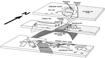
The geology of the Philippines is complex, with the majority of the islands located on the east of the Sunda Plate. To the east of this lies the Philippine Sea plate, which is being subducted beneath the Sunda Plate (a breakaway part of the Eurasian Plate); further east, in the Mariana Islands, the Pacific Plate is being subducted beneath the Philippine Sea Plate. This is not a smooth process, and the rocks of the tectonic plates frequently stick together before eventually being broken apart by the rising pressure, leading to Earthquakes in the process. Material from the subducting Philippine Plate is heated by the temperature of the Earth's interior, causing lighter minerals to melt and the resultant magma to rise through the overlying Sunda Plate, fuelling the volcanoes of the Philippines.

See also...

.jpg)
.jpg)
.gif)
.jpg)
.jpg)


%20(1)%20(1).png)


%20(1).png)


.png)