Showing posts with label Bougainville Island. Show all posts

Tuesday, 25 February 2020

Geologist shot dead in Bougainville, Papua New Guinea.

A geologist has been killed by an unknown assailant in the Bougainville Autonomous Region of Papua New Guinea. Channon Lumpoo, 27, a Thai National, was killed by a single shot from a high-powered riffle while installing equipment in the Kokoda area. He was working for Austhai Geophysical Consultants of Bangkok, who are carrying out surveying work in the area on behalf of the Philippine company SRMI.

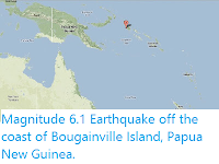
The location of Bougainville Island, Papua New Guinea. Google Maps.

This is the second killing of a geologist in the area within a few months, following the death of Papuan National Terry Win Kilya in December 2019, who was apparently thrown from a cliff while carrying out surveying work for Kalia/Toremana Joint Venture Limited.

Bougainville Island voted for independence from Papua New Guinea in a referendum in December 2019. The island's relationship with the rest of the nation has long been problematic, with a civil war being waged by separatists in the 1990s. One of the major disagreements that have fuelled tensions has been the awarding of mining rights to foreign companies on the island by the Papuan government, which are perceived as brining little benefit to local people, while stripping the island of its natural wealth and damaging the environment.

See also...

https://sciencythoughts.blogspot.com/2019/06/magnitude-50-earthquake-off-southwest.htmlhttps://sciencythoughts.blogspot.com/2017/01/magnitude-79-earthquake-beneath.html
https://sciencythoughts.blogspot.com/2014/04/magnitude-71-earthquake-off-coast-of.htmlhttps://sciencythoughts.blogspot.com/2013/09/magnitude-61-earthquake-off-coast-of.html
Follow Sciency Thoughts on Facebook.

Saturday, 8 June 2019

Magnitude 5.0 Earthquake off the southwest coast of Bougainville Island, Papau New Guinea.

The United States Geological Survey recorded a Magnitude 5.0 Earthquake at a depth of 68.2 km, to the southwest of Bougainville Island, Papua New Guinea, slightly before 9.20 pm local time (slightly before 9.20 am GMT) on Thursday 6 June 2019. There are no reports of any damage or casualties associated with this event, though it may have been felt on the island.

The approximate location of the 6 June 2019 Bougainville Earthquake. USGS.

Bougainville Island lies on the southern fringe of the Pacific Plate. To the south of the island the Solomon Sea Plate is being subducted beneath the Pacific Plate along the Bougainville Trench, passing under the island of Bougainville as it sinks into the Earth. This is not a smooth process; the rocks of the two plates constantly stick together, then break apart as the pressure builds up, causing Earthquakes in the process.

Witness accounts of Earthquakes can help geologists to understand these events, and the structures that cause them. The international non-profit organisation Earthquake Report is interested in hearing from people who may have felt this event; if you felt this quake then you can report it to Earthquake Report here.  

See also...

https://sciencythoughts.blogspot.com/2019/01/eruption-on-manam-moto-papua-new-guinea.htmlhttps://sciencythoughts.blogspot.com/2018/12/eruptions-on-manam-motu-papua-new-guinea.html
https://sciencythoughts.blogspot.com/2018/05/eruptions-on-mount-langila-new-britain.htmlhttps://sciencythoughts.blogspot.com/2018/02/magnitude-75-earthquake-kills-at-least.html
https://sciencythoughts.blogspot.com/2018/01/eruptio-on-kadovar-island-triggers.htmlhttps://sciencythoughts.blogspot.com/2017/11/reassessing-aitape-skull_22.html
Follow Sciency Thoughts on Facebook.

Thursday, 26 January 2017

Magnitude 7.9 Earthquake beneath Bougainville Island.

The United States Geological Survey recorded a Magnitude 7.9 Earthquake at a depth of 136 km,beneath central Bougainville Island, Papua New Guinea, at about 2.30 pm local time (about 4.30 am GMT) on Saturday 22 January 2017. This is a large quake, and was felt across Bourgainville, as well as northern parts of the Solomon Islands, New Britain and mainland Papua New Guinea, and some damage to buildings has been reported on Bougainville.

The approximate location of the 22 January 2017 Bougainville Earthquake. USGS.

Bougainville Island lies on the southern fringe of the Pacific Plate. To the south of the island the Solomon Sea Plate is being subducted beneath the Pacific Plate along the Bougainville Trench, passing under the island of Bougainville as it sinks into the Earth. This is not a smooth process; the rocks of the two plates constantly stick together, then break apart as the pressure builds up, causing Earthquakes in the process.

Witness accounts of Earthquakes can help geologists to understand these events, and the structures that cause them. The international non-profit organisation Earthquake Report is interested in hearing from people who may have felt this event; if you felt this quake then you can report it to Earthquake Report Here

See also...

http://sciencythoughts.blogspot.co.uk/2016/10/magnitude-69-earthquake-beneath-western.htmlhttp://sciencythoughts.blogspot.co.uk/2015/08/injuries-reported-after-eruption-on.html
http://sciencythoughts.blogspot.co.uk/2015/05/magnitude-75-earthquake-off-east-coast.htmlhttp://sciencythoughts.blogspot.co.uk/2014/08/eruptions-on-mount-tavurvur.html
http://sciencythoughts.blogspot.co.uk/2014/04/magnitude-71-earthquake-off-coast-of.htmlhttp://sciencythoughts.blogspot.co.uk/2013/11/landslides-kills-nine-in-papua-new.html
Follow Sciency Thoughts on Facebook.

Friday, 11 April 2014

Magnitude 7.1 Earthquake off the coast of Bougainville Island, Papua New Guinea.

The United States Geological Survey recorded a Magnitude 7.1 Earthquake at a depth of 50 km, to the southwest of Bougainville Island, Papua New Guinea, slightly after 6.05 pm local time (slightly after 7.05 am GMT) on Friday 11 April 2014. This is a large quake, and is likely to have been felt across Bourgainville, as well as northern parts of the Solomon Islands, though there are no reports of any damage or casualties.

The approximate location of the 11 April 2014 Bougainville Earthquake. Google Maps.

Bougainville Island lies on the southern fringe of the Pacific Plate. To the south of the island the Solomon Sea Plate is being subducted beneath the Pacific Plate along the Bougainville Trench, passing under the island of Bougainville as it sinks into the Earth. This is not a smooth process; the rocks of the two plates constantly stick together, then break apart as the pressure builds up, causing Earthquakes in the process.

See also...


Follow Sciency Thoughts on Facebook.

Wednesday, 4 September 2013

Magnitude 6.1 Earthquake off the coast of Bougainville Island, Papua New Guinea.

The United States Geological Survey recorded a Magnitude 6.1 Earthquake at a depth of 49.4 km, roughly 10 km of the southwest coast of Bougainville Island, Papua New Guinea, at 3.30 pm local time (4.30 am GMT) on Monday 2 September 2013. An Earthquake of this size has the potential to inflict substantial damage to the southern part of the Island, but there are no reports of any damage or casualties on this occasion.

The approximate location of the 2 September 2013 Bougainville Earthquake. Google Maps.

Bougainville Island lies on the southern fringe of the Pacific Plate. To the south of the island the Solomon Sea Plate is being subducted beneath the Pacific Plate along the Bougainville Trench, passing under the island of Bougainville as it sinks into the Earth. This is not a smooth process; the rocks of the two plates constantly stick together, then break apart as the pressure builds up, causing Earthquakes in the process.


Follow Sciency Thoughts on Facebook.