Showing posts with label Caribbean Plate. Show all posts

Friday, 28 February 2025

Magnitude 5.9 Earthquake to the northeast of the Dominican Republic.

The United States Geological Survey recorded a Magnitude 5.9 Earthquake at a depth of 46 km roughly 109 km to the northeast of the Dominican Republic, slightly before 1.50 am local time (slightly before 5.50 am GMT) on Tuesday 25 February 2025. There are no reports of any damage or injuries associated with this event, and nor was a tsunami warning issued but people have reported feeling it across the eastern Dominican Republic as well as on Puerto Rico.

The approximate location of the 25 February 2025 Puerto Rico Earthquake. USGS.

The Dominican Republic forms the eastern part of the island of La Hispaniola, in the Greater Antilles.  The island has a complex geological structure, with parts of it lying on three different tectonic plates, and two plate margins running east-to-west across the island. The northernmost part of the island lies on the North American Plate. This is divided from the Gonâve Microplate by the Septentrional Fault Zone, which runs through Rio San Juan, along the north coast of the Dominican Republic and Haiti, then across the Windward Passage and along the south coast of Cuba. The Gonâve Microplate is moving east relative to the North American Plate, pushed by the Mid-Cayman Spreading centre to the west of Jamaica. To the south the Gonâve Microplate is separated from the Caribbean Plate by the Enriquilo-Plantain Garden Fault Zone, which runs across Southern Haiti and the Dominican Republic. To the west the fault runs through central Jamaica. The Caribbean Plate is rotating clockwise, effectively moving east relative to the Gonâve Microplate.

Plate movements and fault zones around the Gonâve Microplate. Mike Norton/Wikimedia Commons.

See also...

Tuesday, 15 October 2024

Magnitude 6.2 Eaarthquake off the coast of Guanacaste Province, Costa Rica.

The United States Geological Survey recorded a Magnitude 6.2 Earthquake at a depth of 16.0 km, off the west ciast of Costa Rica, roughly 41 km to the west of the town of Tamarindo in Guanacaste Province, Costa Rica, slightly before 11.45 am local time (slightly before 5.45 pm GMT) on Saturday 12 October 2024. There are no reports of any damage or casualties associated with this event, but it was felt across much of northern Costa Rica and southern Nicaragua.

The approximate location of the 12 October 2024 Costa Rica Earthquake. USGS.

Costa Rica lies on the southern margin of the Caribbean Plate; to the south of the country the Cocos Plate, which underlies part of the eastern Pacific Ocean) is being subducted under the Middle American Trench, passing under Central America as it sinks into the Earth's interior. This is not a smooth process, and the plates often stick together until the pressure builds up enough to force them to shift suddenly, causing Earthquakes. As the Cocos Plate sinks deeper if is partially melted by the friction and the heat of the Earth's interior. Some of the melted material then rises up through the overlying Caribbean Plate, fuelling the volcanoes of Central America.

Diagram showing the passage of the Cocos Plate beneath Costa Rica (not to scale). Carleton College.

See also...

Wednesday, 26 June 2024

Magnitude 6.0 Earthquake off the north coast of the Paria Peninsula, Venezuela.

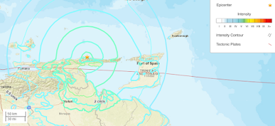
The United States Geological Survey recorded a Magnitude 6.0 Earthquake at a depth of 87.4 km, slightly  off the  north coast of the Paria Peninsula on the north coast of Venezuela, slightly before midnight on Sunday 23  June 2024 local time (slightly before 4.00 am on Monday 24 June GMT). This was a large quake, but at some depth as well as offshore, and there are no reports of any casualties or damage, though the quake was felt over a large area, with people reporting feeling it across much of northern Venezuela, and northeastern Guyana as well as on the Caribbean islands of  Trinidad, Granada, St Vincent.

The approximate location of the 24 June 2024 Paria Peninsula Earthquake. USGS.

The Paria Peninsula forms part of the southern margin of the Caribbean Plate, which is moving eastward compared to the South American Plate, upon which the rest of Venezuela sits. This is not a smooth process, the two plates constantly stick together, then break apart as the pressure builds up, causing Earthquakes in the process. 

See also...

Tuesday, 14 May 2024

Magnitude 6.4 Earthquake off the coast of the Mexico/Guatemala border.

The United States Geological Survey recorded a Magnitude 6.4 Earthquake at a depth of 75.4 km, approximately 17 km off the south coast of the border between Mexico and Guatemala, slightly before 5.40 am local time (slightly before 11.40 am GMT) on Sunday 12 May 2024. This even was felt across much of southern Guatemala, and Chiapas State, Mexico, and triggered a number of small landslides as well as minor damage to some buildings, but there are no reports of any injuries.

The approximate location of the 12 May 2024 Mexico/Guatemala Earthquake. Contour lines show rates of movement during the quake, the red line is the Middle American Trench. USGS.

Mexico is located on the southernmost part of the North American Plate. To the south, along the Middle American Trench, which lies off the southern coast off Mexico, the Cocos Plate is being subducted under the North American Plate, passing under southern Mexico as it sinks into the Earth. Guatemala is located on the southern part of the Caribbean Plate, close to its boundary with the Cocos Plate, which underlies part of the east Pacific. The Cocos Plate is being pushed northwards by expansion of the crust along the East Pacific Rise, and is subducted beneath the Caribbean Plate along the Middle American Trench. This is not a smooth process, and the plates frequently stick together then break apart as the pressure builds up, causing Earthquakes on the process. 

The position of the Cocos, Nazca and Rivera Plates. MCEER/University at Buffalo.

The Cocos Plate is thought to have formed about 23 million years ago, when the Farallon Plate, an ancient tectonic plate underlying the East Pacific, split in two, forming the Cocos Plate to the north and the Nazca Plate to the south. Then, roughly 10 million years ago, the northwesternmost part of the Cocos Plate split of to form the Rivera Plate, south of Beja California.

In a paper published in the Journal of Geophysical Research, in 2012, a team led by Igor Stubailo of the Department of Earth and Space Sciences at the University of California Los Angeles, published a model of the subduction zone beneath Mexico using data from seismic monitoring stations belonging to the Mesoamerican Seismic Experiment, the Network of Autonomously Recording Seismographs, the USArray, Mapping the Rivera Subduction Zone and the Mexican Servicio Sismologico Nacional.

The seismic monitoring stations were able to monitor not just Earthquakes in Mexico, but also Earthquakes in other parts of the world, monitoring the rate at which compression waves from these quakes moved through the rocks beneath Mexico, and how the structure of the rocks altered the movement of these waves.

Based upon the results from these monitoring stations, Stubailo et al. came to the conclusion that the Cocos Plate was split into two beneath Mexico, and that the two plates are subducting at different angles, one steep and one shallow. Since the rate at which a plate melts reflects its depth within the Earth, the steeper angled plate melts much closer to the subduction zone than the shallower angled plate, splitting the Trans-Mexican Volcanic Belt into sections above the different segments of the Cocos Plate, and causing it to apparently curve away from the subduction zone.

Top the model of the Cocos Plate beneath Mexico, split into two sections (A & B) subducting at differing angles. (C) Represents the Rivera Plate, subducting at a steeper angle than either section of the Cocos Plate. The Split between the two has been named the Orozco Fracture Zone (OFZ) which is shown extended across the Cocos Plate; in theory this might in future split the Cocos Plate into two segments (though not on any human timescale). Bottom Left, the position of the segments on a map of Mexico. Darker area is the Trans-Mexican Volcanic Belt, orange circles are volcanoes, brown triangles are seismic monitoring stations, yellow stars are major cities. Bottom Right, an alternative model showing the subducting plate twisted but not split. This did not fit the data. Stubailo et al. (2012).

See also...

Thursday, 20 July 2023

Magnitude 6.5 Earthquake off the coast of EL Salvador.

The United States Geological Survey recorded a Magnitude 6.5 Earthquake at a depth of 69.7 km, roughly 43 km offshore of the municipality of Intipucá in La Unión Department, El Salvador, slightly after 6.20 pm local time on Tuesday 18 July 2023 (slightly after 0.20 am on Wednesday 19 July, GMT). The quake was felt across much of Central America, from southern Mexico to Costa Rica, though there are no reports of any major damage or injuries.

The approximate location of the 18 July 2023 El Salvador Earthquake. USGS.

El Salvador and the other countries of Central America are located on the southern part of the Caribbean Plate, close to its boundary with the Cocos Plate, which underlies part of the east Pacific. The Cocos Plate is being pushed northwards by expansion of the crust along the East Pacific Rise, and is subducted beneath the Caribbean Plate along the Middle American Trench, which runs parallel to the south coast of Central America, passing under the peninsula as it sinks into the Earth's interior. This is not a smooth process, the plates tend to stick together, breaking apart again once the pressure from the northward movement of the Cocos Plate builds up to much, triggering Earthquakes. 

See also...

Follow Sciency Thoughts on Facebook.

Follow Sciency Thoughts on Twitter


Wednesday, 7 June 2023

Four dead following Magnitude 4.9 Earthquake in Haiti.

The United States Geological Survey recorded a Magnitude 4.9 Earthquake at a depth of 10.0 km roughly 9 km to the northeast of the commune of Les Abricots on the northern side of the Tiburon Peninsula, Haiti, slightly after 5.10 am local time (slightly after 9.10 am GMT) on Tuesday 6 June 2023. Four people are known to have died following this event, and injuring more than 25, including several children. Three of the deceased are reported to be members of the same family, killed when their house collapsed. 

The approximate location of the 6 June 2023 Haiti Earthquake. USGS.

Haiti forms the western part of the island of La Hispaniola, in the Greater Antilles. The island has a complex geological structure, with parts of it lying on three different tectonic plates, and two plate margins running east-to-west across the island. The northernmost part of the island lies on the North American Plate. This is divided from the Gonâve Microplate by the Septentrional Fault Zone, which runs through Rio San Juan, along the north coast of the Dominican Republic and the Tiburon Peninsula of Haiti, then across the Windward Passage and along the south coast of Cuba. The Gonâve Microplate is moving east relative to the North American Plate, pushed by the Mid-Cayman Spreading centre to the west of Jamaica. To the south the Gonâve Microplate is separated from the Caribbean Plate by the Enriquilo-Plantain Garden Fault Zone, which runs across Southern Haiti and the Dominican Republic. To the west the fault runs through central Jamaica. The Caribbean Plate is rotating clockwise, effectively moving east relative to the Gonâve Microplate.

Plate movements and fault zones around the Gonâve Microplate. Mike Norton/Wikimedia Commons.

See also...

Follow Sciency Thoughts on Facebook.

Follow Sciency Thoughts on Twitter.