Showing posts with label Middle American Trench. Show all posts

Tuesday, 15 October 2024

Magnitude 6.2 Eaarthquake off the coast of Guanacaste Province, Costa Rica.

The United States Geological Survey recorded a Magnitude 6.2 Earthquake at a depth of 16.0 km, off the west ciast of Costa Rica, roughly 41 km to the west of the town of Tamarindo in Guanacaste Province, Costa Rica, slightly before 11.45 am local time (slightly before 5.45 pm GMT) on Saturday 12 October 2024. There are no reports of any damage or casualties associated with this event, but it was felt across much of northern Costa Rica and southern Nicaragua.

The approximate location of the 12 October 2024 Costa Rica Earthquake. USGS.

Costa Rica lies on the southern margin of the Caribbean Plate; to the south of the country the Cocos Plate, which underlies part of the eastern Pacific Ocean) is being subducted under the Middle American Trench, passing under Central America as it sinks into the Earth's interior. This is not a smooth process, and the plates often stick together until the pressure builds up enough to force them to shift suddenly, causing Earthquakes. As the Cocos Plate sinks deeper if is partially melted by the friction and the heat of the Earth's interior. Some of the melted material then rises up through the overlying Caribbean Plate, fuelling the volcanoes of Central America.

Diagram showing the passage of the Cocos Plate beneath Costa Rica (not to scale). Carleton College.

See also...

Tuesday, 14 May 2024

Magnitude 6.4 Earthquake off the coast of the Mexico/Guatemala border.

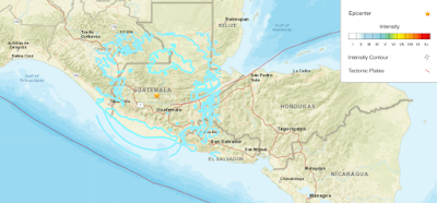
The United States Geological Survey recorded a Magnitude 6.4 Earthquake at a depth of 75.4 km, approximately 17 km off the south coast of the border between Mexico and Guatemala, slightly before 5.40 am local time (slightly before 11.40 am GMT) on Sunday 12 May 2024. This even was felt across much of southern Guatemala, and Chiapas State, Mexico, and triggered a number of small landslides as well as minor damage to some buildings, but there are no reports of any injuries.

The approximate location of the 12 May 2024 Mexico/Guatemala Earthquake. Contour lines show rates of movement during the quake, the red line is the Middle American Trench. USGS.

Mexico is located on the southernmost part of the North American Plate. To the south, along the Middle American Trench, which lies off the southern coast off Mexico, the Cocos Plate is being subducted under the North American Plate, passing under southern Mexico as it sinks into the Earth. Guatemala is located on the southern part of the Caribbean Plate, close to its boundary with the Cocos Plate, which underlies part of the east Pacific. The Cocos Plate is being pushed northwards by expansion of the crust along the East Pacific Rise, and is subducted beneath the Caribbean Plate along the Middle American Trench. This is not a smooth process, and the plates frequently stick together then break apart as the pressure builds up, causing Earthquakes on the process. 

The position of the Cocos, Nazca and Rivera Plates. MCEER/University at Buffalo.

The Cocos Plate is thought to have formed about 23 million years ago, when the Farallon Plate, an ancient tectonic plate underlying the East Pacific, split in two, forming the Cocos Plate to the north and the Nazca Plate to the south. Then, roughly 10 million years ago, the northwesternmost part of the Cocos Plate split of to form the Rivera Plate, south of Beja California.

In a paper published in the Journal of Geophysical Research, in 2012, a team led by Igor Stubailo of the Department of Earth and Space Sciences at the University of California Los Angeles, published a model of the subduction zone beneath Mexico using data from seismic monitoring stations belonging to the Mesoamerican Seismic Experiment, the Network of Autonomously Recording Seismographs, the USArray, Mapping the Rivera Subduction Zone and the Mexican Servicio Sismologico Nacional.

The seismic monitoring stations were able to monitor not just Earthquakes in Mexico, but also Earthquakes in other parts of the world, monitoring the rate at which compression waves from these quakes moved through the rocks beneath Mexico, and how the structure of the rocks altered the movement of these waves.

Based upon the results from these monitoring stations, Stubailo et al. came to the conclusion that the Cocos Plate was split into two beneath Mexico, and that the two plates are subducting at different angles, one steep and one shallow. Since the rate at which a plate melts reflects its depth within the Earth, the steeper angled plate melts much closer to the subduction zone than the shallower angled plate, splitting the Trans-Mexican Volcanic Belt into sections above the different segments of the Cocos Plate, and causing it to apparently curve away from the subduction zone.

Top the model of the Cocos Plate beneath Mexico, split into two sections (A & B) subducting at differing angles. (C) Represents the Rivera Plate, subducting at a steeper angle than either section of the Cocos Plate. The Split between the two has been named the Orozco Fracture Zone (OFZ) which is shown extended across the Cocos Plate; in theory this might in future split the Cocos Plate into two segments (though not on any human timescale). Bottom Left, the position of the segments on a map of Mexico. Darker area is the Trans-Mexican Volcanic Belt, orange circles are volcanoes, brown triangles are seismic monitoring stations, yellow stars are major cities. Bottom Right, an alternative model showing the subducting plate twisted but not split. This did not fit the data. Stubailo et al. (2012).

See also...

Thursday, 20 July 2023

Magnitude 6.5 Earthquake off the coast of EL Salvador.

The United States Geological Survey recorded a Magnitude 6.5 Earthquake at a depth of 69.7 km, roughly 43 km offshore of the municipality of Intipucá in La Unión Department, El Salvador, slightly after 6.20 pm local time on Tuesday 18 July 2023 (slightly after 0.20 am on Wednesday 19 July, GMT). The quake was felt across much of Central America, from southern Mexico to Costa Rica, though there are no reports of any major damage or injuries.

The approximate location of the 18 July 2023 El Salvador Earthquake. USGS.

El Salvador and the other countries of Central America are located on the southern part of the Caribbean Plate, close to its boundary with the Cocos Plate, which underlies part of the east Pacific. The Cocos Plate is being pushed northwards by expansion of the crust along the East Pacific Rise, and is subducted beneath the Caribbean Plate along the Middle American Trench, which runs parallel to the south coast of Central America, passing under the peninsula as it sinks into the Earth's interior. This is not a smooth process, the plates tend to stick together, breaking apart again once the pressure from the northward movement of the Cocos Plate builds up to much, triggering Earthquakes. 

See also...

Follow Sciency Thoughts on Facebook.

Follow Sciency Thoughts on Twitter


Friday, 19 May 2023

Magnitude 6.4 Earthquake beneath southern Guatemala.

The United States Geological Survey Recorded a Magnitude 6.4 Earthquake at a depth of 252 km about 2 km to the southeast of the town of Canillá, in El Quiché Department, Guatemala, slightly after 11.00 pm local time (slightly after 5.00 pm GMT) on Wednesday 17 May 2023. No injuries or damage have been reported following this event, but the Earthquake was felt across most of Guatemala, plus parts of southern Mexico and El Salvador. Such a pattern is typical of Earthquakes at great depth, where the energy tends ti be dispersed over a wide area by the time it reaches the surface.

The approximate location of the 17 May 2023 Guatemala Earthquake. USGS.

Guatemala is located on the southern part of the boundary between the North American and Caribbean Plates, close to their boundary with the Cocos Plate, which underlies part of the east Pacific. The Cocos Plate is being pushed northwards by expansion of the crust along the East Pacific Rise, and is subducted beneath the North American and Caribbean Plates along the Middle American Trench, which runs parallel to the south coast of Guatemala and neighbouring countries, passing under Central America as it sinks into the Earth's interior. This is not a smooth process, the plates tend to stick together, breaking apart again once the pressure from the northward movement of the Cocos Plate builds up to much, triggering Earthquakes.

Diagrammatic representation of the subduction of the Cocos Plate beneath the Caribbean Plate along the Middle American Trench. VCS Mining.

See also...

Follow Sciency Thoughts on Facebook.

Follow Sciency Thoughts on Twitter.


Saturday, 6 May 2023

Over 1000 people evacuated from nearby communities as Mount Fuego erupts in Guatemala.

Over 1000 people have been evacuated from five communities close to Mount Fuego, a 3768 m high stratovolcano (cone shaped volcano made up of layers of ash and lava) that forms part of La Horqueta volcanic complex in the southern part of Guatemala, after a sudden increase in volcanic activity on Thursday 4 May 2023. The volcano produced a column of ash which reached about 5800 m above sealevel (about 2000 m above the summit of the volcano) as well as several pyroclastic flows (avalanches of hot ash and gas). A number of flights had to be diverted away from the region as a precaution, and communities within 7 km of the volcano have been evacuated as a precaution.

An eruption on Mount Fuego, Guatemala, on 4 May 2023. Reuters.

Fuego has been more-or-less constantly active at some level since records in the area began (circa 1524). It forms part of La Horqueta volcanic complex, which also includes the Acatenango volcano to the north, a complex volcano with at least five separate vents, the complex siting on the site of the ancient Meseta volcano, which is thought to have collapsed following a major volcanic episode about 8500 years ago, causing a debris flow that reached the sea, 50 km away.

An ash column over Mount Fuego on 4 May 2023. Reuters.

The volcanoes of Guatemala, and Central America in general, are fed by the subduction of the Cocos Plate beneath the Caribbean Plate along the Middle American Trench, which runs roughly parallel to the southwest coast of the isthmus. As the Cocos Plate sinks into the Earth, it passes under Central America, which lies on the western margin of the Caribbean Plate. As this happens it is heated by the friction and the heat of the planet's interior, causing the sinking plate to partially melt. Some of the melted material then rises through the overlying Caribbean Plate as magma, fueling the volcanoes of Central America.

Diagrammatic representation of the subduction of the Cocos Plate beneath the Caribbean Plate along the Middle American Trench. VCS Mining.

See also...

Follow Sciency Thoughts on Facebook.

Follow Sciency Thoughts on Twitter.


Monday, 24 April 2023

Eruption on Rincón de la Vieja volcano, Costa Rica.

The Comisión Nacional de Emergencias in Costa Rica has reported a large eruption on Rincón de la Vieja, an active volcano in Guanacaste Province.in the northwest of the country, on Friday 21 April 2023. The volcano produced an ash column about 7.5 km high, and part of the northern perimeter of the volcano's caldera was breached, causing ash-laden waters from the volcano's lake to escape, and triggering a series of lahars along the courses of the Pénjamo, Azúl and Azufrada rivers. This event is not thought to have caused any injuries or damage to infrastructure, but people are being warned to keep away from the affected waterways.

An ash column over the Rincon de La Vieja volcano, Costa Rica, on 21 April 2023. Observatorio Vulcanológico y Sismológico de Costa Rica-Universidad Nacional.

Rincón de la Vieja is a complex volcano (volcano with multiple eruptive vents rather than a single crater at the top of a cone-shaped mountain) rising to 1916 m above sea-level in Guanacaste Province in the northwest of Costa Rica. It is located within the Rincón de la Vieja National Park, where along with an associated hot spring system it forms an important part of the local economy. Prior to the onset of activity in September 2014 the volcano had been inactive since September 2011, and the last major eruption occurred in 1966. A small geothermal energy project, the Las Pailas Geothermal Power Plant, runs on heat from underground rocks associated with the volcanic complex.

Rincón de la Vieja forms part of the Cordillera de Guanacaste, a range of volcanic mountains running through northern Costa Rica close to the border with Nicaragua and forming part of the Central American Arc. These volcanoes are fueled by the subduction of the Cocos Plate, which underlies part of the east Pacific Ocean, beneath the Caribbean Plate, on which Central America lies, along the Middle American Trench, which lies off the south coast of the country. As the Cocos Plate is subducted it is gradually melted by the heat and pressure of the Earth's interior, with some more volatile minerals rising through the overlying Caribbean Plate as volcanic magma.

Diagram showing the passage of the Cocos Plate beneath Costa Rica (not to scale). Carleton College.

See also...

Follow Sciency Thoughts on Facebook.

Follow Sciency Thoughts on Twitter