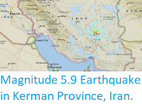
The United States Geological Survey
recorded a Magnitude 5.4 Earthquake at a depth of 10.0 km roughly 73 km to the north of the city of Bandar-e Lengeh in Hormozgān Province, Iran, slightly before 2.00 pm local time (slightly before 11.00 am
GMT) on Friday 21 October 2019. There are no reports of any damage or
casualties associated with this event, but it was felt across much of southern Iran, as well as in Bahrain and the United Arab Emirates.

The
location of the 21 October 2019 Hormozgān Province Earthquake. Contour
lines show rates of movement during the quake, the red line is a
boundary between two tectonic plates, in this case the Arabian and Eurasian plates. USGS.
Iran is situated on the southern margin of the Eurasian Plate.
Immediately to the south lies the Arabian Plate, which is being pushed
northward by the impact of Africa from the south. This has created a
zone of faulting and fold mountains along the southwest coast of the
country, known as the Zagros Thrust Belt, while to the northeast of this
the geology is dominated by three large tectonic blocks, the Central
Iran, Lut and Helmand, which move separately in response to pressure
from the south, stretching and compressing the rock layers close to the
surface and creating frequent Earthquakes, some of which can be very
large.

The movement of the Arabian Plate and extent of the Zagros Thrust Belt. Rasoul Sorkhabi/Geo ExPro.
To the northeast of this the geology is dominated by three large
tectonic blocks, the Central Iran, Lut and Helmand, which move
separately in response to pressure from the south, stretching and
compressing the rock layers close to the surface and again creating frequent
Earthquakes.
The population of Iran is particularly at risk from Earthquakes as,
unlike most other Earthquake-prone nations, very few buildings in the
country are quake-resistant. The majority of residential buildings in
Iran are made of mud-brick, a building material particularly vulnerable
to Earthquakes as the bricks often liquefy, trapping people inside and
quickly asphyxiating them with dust. This is particularly dangerous at
night when the majority of people are inside sleeping.

Section through the Zagros Fold Belt. Sarkarinejad & Azizi (2007).
Witness
accounts of Earthquakes can help geologists to understand these events,
and the structures that cause them. The international non-profit
organisation Earthquake Report is interested in hearing from people who may have felt this event; if you felt this quake then you can report it to Earthquake Report here.
See also...


Follow Sciency Thoughts on Facebook.