Showing posts with label Kerman Province. Show all posts

Friday, 18 October 2019

Mirabad-e Emam Qoli: A Sassanid-era fire temple in south-eastern Iran.

The Sassanid kingdom ruled in Iran from 224 to 651 AD, at its peak ruling an empire that included Egypt, Afghanistan, much of the Arabian Peninsula and half of Anatolia, making it a serious rival to the Late Roman Empire. The Sassanids practised a form of Zoroastrianism, a religion which has its origins in ancient Persia, and which is still practised in India today. Zoroastrianism is considered to have been a major influence on Persian culture, which is still influential in modern Iran, though most religious structures associated with the religion were lost during the Islamic invasion between 637 and 651.

In a paper published in the journal Antiquity on 18 February 2019, Leyla Fazel and Yaghoub Mohammadifar of the Archaeology Department at Bu-Ali Sina University describe the remains of a Sassinid fire temple at Mirabad-e Emam Qoli, in the eastern part of Kerman Province in south-eastern Iran, that was discovered during an archaeological survey at the Bam World Heritage Site in 2013.

The fire temple is located 12 km to the north of Mohammadabad, the capital of Rigan County, on the the southern margin of the Kavir-e Lut (Lut Desert), and thus experiences an arid desert climate, windstorms and sandstorms. 

 Map of Iran, with location of the Mirabad-e Emam Qoli fire temple. Fazel & Mohammadifar (2019).

The temple is mostly covered with debris and sand up to the rise of the arches of the doorways, The walls are covered with clay and straw. The main part of the structure is currently situated below ground level and cannot be seen from a distance. The roofing has not survived in most parts of the building. There are extensions and additions to the building on all sides, the remnants of which have formed mounds around the main structure.

The structure consists of a single building featuring the typical characteristics of Sassanid religious architecture. The main building is a rectangular structure measuring 13 m by 17.4 m. The ground plan of this area includes a cruciform central chamber, four doorways on the four sides and a vestibule around the central space. The chamber in the centre measures 4 m by 4 m. The depth of the doorways is 3.3 m on the north side, and 2.1 m on the other three sides. The vestibules are 3.25 m wide along the north side, and nearly 1.3 m wide on the other sides. The vestibules lead to the area surrounding the fire temple through doorways in each of the four sides. Remnants of a chamber measuring 3.1 m by 5.4 m along the west side and another one measuring 3.3 by 3 m on the south side are still standing. The tallest part of the structure, along the eastern side, is 1.6m high. The building is mainly made of bricks measuring  40 cm by 40 cm by 10 cm.

Evidence from aerial images suggests that the fire temple was surrounded by several other buildings. The structures that can still be distinguished are located to the south-west of the temple, and stand on a mound approximately 5m in height. The ground plan is rectangular, measuring 31 m by 41 m. This was probably a castle, caravansary or a similar type of accommodation block. Such complexes are often associated with Sassanid fire temples and would have provided pilgrims and site attendants with accommodation.

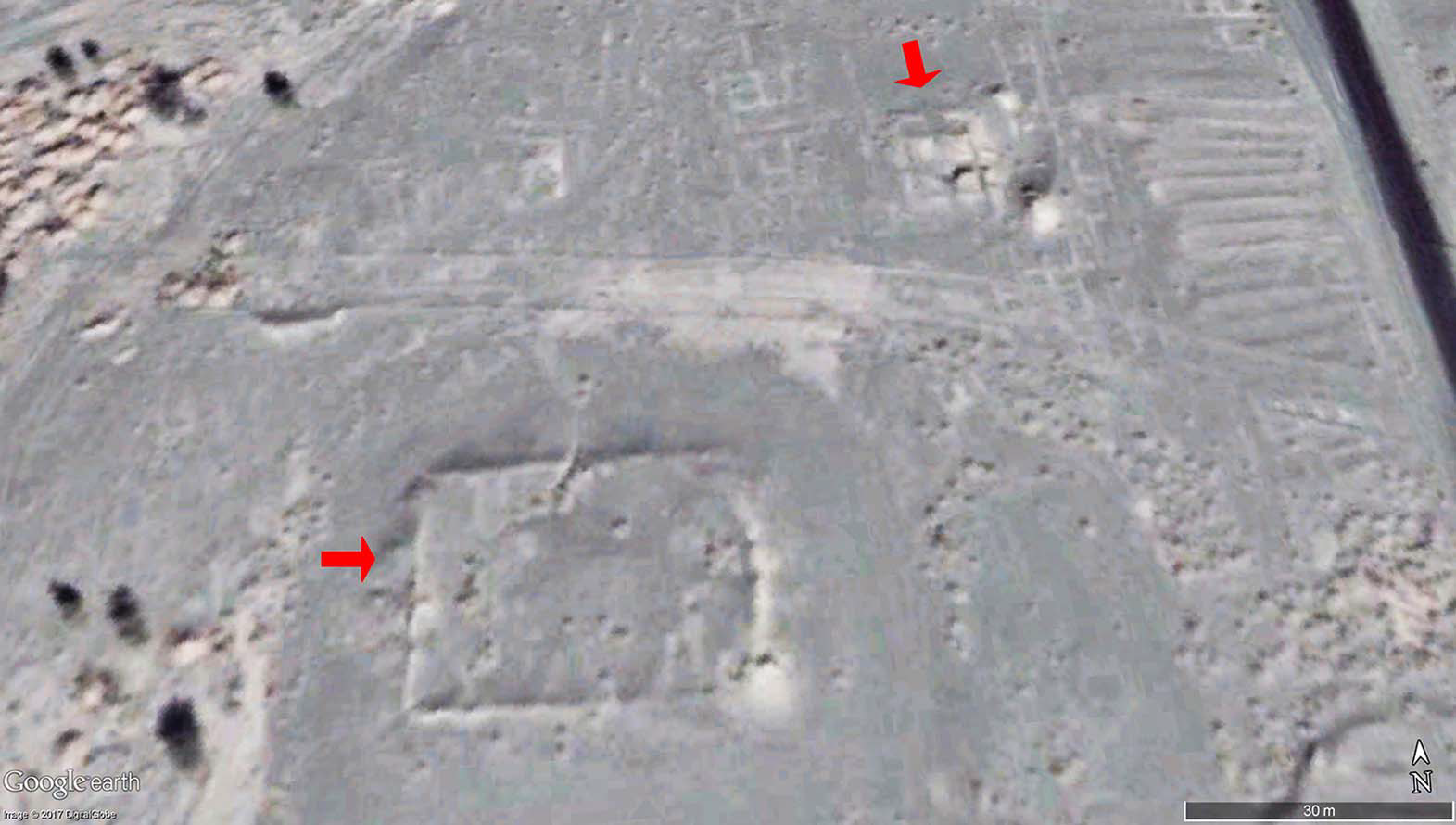
Aerial image of the fire temple (top-right arrow) and the possible castle/caravansary/accommodation block (bottom-left arrow), made using Google EarthFazel & Mohammadifar (2019).

The most significant feature of this structure is the fire altar at the centre. The upper compartment of the altar is a cube measuring 1.6 m on each side, and has at least four stepped layers. This fire altar confirms the function of the structure as a fire temple. The visible part of the fire altar is made of large baked bricks covered with a gypsum plaster. The censer is covered with debris. There is a hole in one of the corners of the fire altar, which was presumably used to feed the flames with oils or other aromatic substances.

The visible parts of the fire altar are similar to those depicted on Sassanid coins, and to the stone fire altar of Qanat Baq. The fire altar is situated slightly below the rise of the eastern arch, which suggests that the fire altar pedestal originally feature a rather tall, column-like structure. The exact form of the main altar slab and its supports is, however, unknown due to the debris that covers them.

The east side of the fire temple. Leyla Fazel in Fazel & Mohammadifar (2019).

Theplanof this fire temple is similar to that of the Konar Siyah, Tol Jangi and Khormayak fire temples in Fars, the Negar fire temple in Kerman, the Juliyan fire temple in Abdanan and the Mil-e Milgah fire temple in Kermanshah. While these all date back to the Sassanid reign, finer chronological precision is not currently possible.

See also...

https://sciencythoughts.blogspot.com/2019/05/mapping-gerasa.htmlhttps://sciencythoughts.blogspot.com/2018/08/britain-returnd-looted-sumerian.html
https://sciencythoughts.blogspot.com/2018/07/micromammals-from-byzantine.htmlhttps://sciencythoughts.blogspot.com/2017/04/gobekli-tepe-does-ancient-anatolian.html
https://sciencythoughts.blogspot.com/2015/05/philistine-and-hellenistic-remains-from.htmlhttps://sciencythoughts.blogspot.com/2014/06/does-catalhoyuk-mural-depict-volcanic.html
Follow Sciency Thoughts on Facebook.

Tuesday, 12 December 2017

Magnitude 5.9 Earthquake in Kerman Province, Iran.

The United States Geological Survey recorded a Magnitude 5.9 Earthquake at a depth of 10.0 km about 56 to the northeast of the city of Kerman, the Iranian province of the same name, slightly before 12.15 pm local time (slightly before 8.45 am GMT) on Tuesday 12 December 2017. The was felt across much of Iran, and is reported to have destroyed more than 50 houses, as well as injuring at least 43 people, though none of those injured is described as being in a life-threatening condition.

The approximate location of the 12 December 2017 Kerman Earthquake. USGS.

Iran is situated on the southern margin of the Eurasian Plate. Immediately to the south lies the Arabian Plate, which is being pushed northward by the impact of Africa from the south. This has created a zone of faulting and fold mountains along the southwest coast of the country, known as the Zagros Thrust Belt, while to the northeast of this the geology is dominated by three large tectonic blocks, the Central Iran, Lut and Helmand, which move separately in response to pressure from the south, stretching and compressing the rock layers close to the surface and creating frequent Earthquakes, some of which can be very large.

The movement of the Arabian Plate and extent of the Zagros Thrust Belt. Rasoul Sorkhabi/Geo ExPro.

To the northeast of this the geology is dominated by three large tectonic blocks, the Central Iran, Lut and Helmand, which move separately in response to pressure from the south, stretching and compressing the rock layers close to the surface and again creating frequent Earthquakes.

The population of Iran is particularly at risk from Earthquakes as, unlike most other Earthquake-prone nations, very few buildings in the country are quake-resistant. The majority of residential buildings in Iran are made of mud-brick, a building material particularly vulnerable to Earthquakes as the bricks often liquefy, trapping people inside and quickly asphyxiating them with dust. This is particularly dangerous at night when the majority of people are inside sleeping.

 Section through the Zagros Fold Belt. Sarkarinejad & Azizi (2007).

Witness accounts of Earthquakes can help geologists to understand these events, and the structures that cause them. The international non-profit organisation Earthquake Report is interested in hearing from people who may have felt this event; if you felt this quake then you can report it to Earthquake Report here.
 
See also...
 
http://sciencythoughts.blogspot.co.uk/2017/08/magnitude-52-earthquake-in-hormozgan.html
http://sciencythoughts.blogspot.co.uk/2017/11/magnitude-73-earthquake-in-kermanshah.html
 
http://sciencythoughts.blogspot.co.uk/2017/05/twenty-one-confirmed-fatalities.html
http://sciencythoughts.blogspot.co.uk/2014/04/magnitude-44-earthquake-in-khuzestan.html
http://sciencythoughts.blogspot.co.uk/2014/04/magnitude-50-earthquake-on-coast-of.html

Follow Sciency Thoughts on Facebook.
 

Saturday, 29 September 2012

A new species of Blister Beetle from southeast Iran.

Blister Beetles (Meloidae) are a widespread group of Beetles, easily distinguished by their elongate shape and bright colours, which serve as a warning to predators. The Beetles secrete Cantharidin, a toxic chemical which acts as a blistering agent, when alarmed. The adult Beetles are primarily pollen and nectar feeders, but the larval forms are carnivorous, often consuming Bees or Grasshopper eggs.

In a paper published in the journal ZooKeys on 4 September 2012, Sayeh Serri of the Insect Taxonomy Research Department at the Iranian Research Institute of Plant Protection and Zhao Pan and Marco Bologna of the Dipartimento di Biologia Ambientale at the Università Roma Tre, describe a new species of Blister Beetle from Kerman Province in southeast Iran. The new species is based upon speciemens collected in 1969 and placed in the collection of the Hayk Mirzayans Insect Museum of the Iranian Research Institute of Plant Protection, the paper being part of a wider study on the Blister Beetles of Iran.

The new species is placed in the pre-existing genus and sub-genus Mylabris (Mylabris), and given the specific name barezensis, in reference to the Jebal Barez mountain range, where the Beetles were collected. Mylabris (Mylabris) barezensis is a 10-15 mm black Beetle with sub-oval brown spots.

Mylarbris (Mylabris) barezensis. Serri et al. (2012)