Showing posts with label Halmahera Arc. Show all posts

Wednesday, 13 May 2026

Three hikers killed by eruption on Mount Dukono

Three hikers were killed in an eruption on Mount Dukono, a 1273 m high volcano on the northern part of Halmahera Island, Indonesia, on Friday 8 May 2026. The three were part of a group of 20 Indonesian and Singaporean hikers which had trekked up the volcano under the leadership of Indonesian tour guide Reza Selang. The hike was undertaken despite a prohibition on climbing the volcano which had been in place since 17 April, due to a high level of volcanic activity. However, Selang claims he was unaware of this prohibition, and was not made aware of it by local villagers he employs as assistants. Local authorities, meanwhile, claim to have posted warnings on social media and place banners at the entrance to trails leading to the volcano.

An ash column over Mount Dukuno on 8 May 2026. Jhon Frengki Manipa/Reuters.

The group ascended the volcano early in the morning, with Selang sending a drone to the volcano's summit to check for volcanic activity, before sending up a group of fourteen hikers under the leadership of Singaporean tour organiser Timothy Heng, who had booked the trip through Selang last year, while Selang remained lower down with the remainder of the group. At about 7.40 Selang sent his drone up again to check on the group, when the volcano underwent two explosive eruptions in rapid succession, the first producing only smoke, but the second ejecting large volumes of ash, rock, and other debris. 

The group on the mountain scattered and ran downhill in response to this, though Selang reports seeing one man, Singaporean Shahin Muhrez bin Abdul Hamid lying on the ground near the crater. He states that he then ascended the summit along with Heng, who had escaped the initial blast, with the two of them attempting to rescue the injured man. During this attempt both Singaporeans were hit and killed by a large rock, with only Selang escaping.

Selang and the majority of the group made it back to the base of the mountain, where they discovered another person was missing, Indonesian Angel Krishela Pradita. They then notified the local authorities, who sent out a rescue team, who later recovered the bodies of all three missing hikers. The survivors were treated for injuries at a local hospital.

Rescue workers recovering the body of one of the hikers killed on Mount Dukono on 8 May 2026. Badan Nasional Penanggulangan Bencana.

Dukono is one of Indonesia's most active volcanoes, having been erupting more-or-less continuously since 1933. Eruptions most frequently take the form of ash explosions and sulphur dioxide plumes, with lave flows also being reasonably common. The volcano also went a major eruptive phase in the mid sixteenth century, as well as shorter episodes in the eighteenth, nineteenth, and early twentieth centuries.

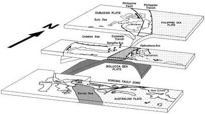
The Halmahera Islands arc a volcanic arc; formed where one tectonic plate is being subducted beneath another, with the underlying plate being melted by the heat of the Earth's interior, and lighter minerals bubbling up through the overlying plate to form volcanoes. However the Halmahera Islands are unusual in that they lie on a double subduction zone. The underlying plate, a northeaster extension of the Molucca Plate, is being overridden form the Philippine Plate from the east and the Eurasian Plate from the west. The Halmahera volcanoes are located where the Philippine Plate is overriding the Molucca Plate; to the west the Sangihe Islands lie where the Molucca Plate is being overridden by the Eurasian Plate.

Diagrammatic representation of the subduction zones beneath Halmahera (middle), plus the Philippines (top) and Sulawesi (bottom), with the Eurasian Plate to the left, the Molucca Sea Plate in the middle, and the Philippine Plate to the right.  Hall & Wilson (2000).

See also...

Thursday, 21 August 2025

Two deaths following Magnitude 5.8 Earthquake beneath Central Sulawesi, Indonesia.

The United States Geological Survey recorded a Magnitude 5.8 Earthquake at a depth of 12 km, approximately 12 km to the northwest of the town of Poso in Central Sulawesi Province, Indonesia, slightly before 6.40 am local time on Sunday 17 August 2025 (slightly before 10.40 pm on Sunday 16 August, GMT). Twenty nine people are known to have been injured during this event, two of whom subsequently died, one later on the day of the event, and one on Tuesday 19 August. The initial quake was followed by a series of aftershocks.

The approximate location of the 17 August 2025  Central Sulawesi Province Earthquake. USGS.

The tectonic situation beneath Sulawesi is complex, as it is caught in the collisional zone between the Eurasian, Pacific and Australian Plates. The north of the island is located on a breakaway section of the Eurasian Plate, called the Sangihe Plate. To the east lies the remnant Molucca Sea Plate, which is being subducted beneath both the Sangihe Plate and the more easterly Halmahera Plate, leading to Earthquakes and volcanism on Sulawesi and the islands of the Sangihe Arc in the west and the islands of the Halmahera Arc in the east.

The subduction zones beneath Sulawesi and the surrounding islands. Hall & Spakman (2015).

See also...

Sunday, 19 January 2025

Evacuations ordered after increase in activity from Mount Ibu on Halmahera Island, Indonesia.

Authorities in North Maluku Province, Indonesia, have ordered the evacuation of six villages close to Mount Ibu, a 1325 m stratovolcano on the northwest coast of Halmahera Island, following a series of eruptions in the first two weeks of 2025. Mount Ibu began its current eruptive cycle in June 2024, but January has seen a significant rise in activity, with more than a thousand eruptions have been recorded on the volcano this year, with the largest producing ash columns reaching as high as 4 km over the summit of the volcano. However, to date only one village, with a population of 517 people, has been evacuated, with about 2500 people in the remaining five villages reluctant to leave without first harvesting crops.

An eruption on Mount Ibu, Halmahera Island, on Wednesday 15 January 2024. Azzam/AFP.

The Halmahera Island chain is a volcanic arc formed where the Halmahera Plate, a northeaster extension of the Molucca Sea Plate is being subducted beneath Philippine Plate from the east and the Eurasian Plate from the west, with the underlying plate being melted by the heat of the Earth's interior, and lighter minerals bubbling up through the overlying plate to form volcanoes. The Halmahera volcanoes are located where the Philippine Plate is overriding the Molucca Sea Plate; to the west the Sangihe Islands lie where the Molucca Sea Plate is being overridden by the Eurasian Plate.

Diagrammatic representation of the subduction zones beneath Halmahera (middle), plus the Philippines (top) and Sulawesi (bottom), with the Eurasian Plate to the left, the Molucca Sea Plate in the middle, and the Philippine Plate to the right.  Hall & Wilson (2000).

See also...

Sunday, 19 May 2024

Exclusion area around Mount Ibu, Halmahera Island, extended following new eruption.

The Indonesian Center for Volcanology and Geological Hazard Mitigation has extended the exclusion zone around  Mount Ibu, a 1325 m stratovolcano on the northwest coast of Halmahera Island, following a new eruption on 18 May 2024. A two kilometre exclusion zone had already been put in place after the volcano began erupting on 28 April, but this has been increased to seven kilometres following the most recent eruption, which produced an ash column which rose to 4 km above the volcano's summit, resulting in seven villages needing to be evacuated. 

An ash column and lava fountain above Mount Ibu on the Indonesian island of Halmahera on 18 May 2024. Several lightning discharges can be seen within the ash column; ash columns can build up considerable charge variations leading to frequent electrical discharges. Indonesian Center for Volcanology and Geological Hazard Mitigation/Reuters.

The Halmahera Island chain is a volcanic arc formed where the Halmahera Plate, a northeaster extension of the Molucca Sea Plate is being subducted beneath Philippine Plate from the east and the Eurasian Plate from the west, with the underlying plate being melted by the heat of the Earth's interior, and lighter minerals bubbling up through the overlying plate to form volcanoes. The Halmahera volcanoes are located where the Philippine Plate is overriding the Molucca Sea Plate; to the west the Sangihe Islands lie where the Molucca Sea Plate is being overridden by the Eurasian Plate.

Diagrammatic representation of the subduction zones beneath Halmahera (middle), plus the Philippines (top) and Sulawesi (bottom), with the Eurasian Plate to the left, the Molucca Sea Plate in the middle, and the Philippine Plate to the right.  Hall & Wilson (2000).

See also...

Monday, 29 April 2024

Eruption on Mount Ibu, Halmahera Island, Indonesia.

The Regional Disaster Mitigation Agency for West Halmahera District has reported an eruption on Mount Ibu, a 1325 m stratovolcano on the northwest coast of Halmahera Island, Indonesia, on Sunday 28 April  2024 (a stratovolcano is a cone-shaped volcano made up of layers of ash and lava, although Mount Ibu has a truncated shape, having lost its upper part in an explosion at some point in the past). The eruption started at 0.37 am local time, and lasted approximately three minutes and 26 seconds, producing a column of dark ash which rose 3.5 km above the summit of the volcano and drifted to the west. The Regional Disaster Mitigation Agency has asked people not to go within 2 km of the volcano for the time being, and has issued dust masks to residents of 16 villages in the area. Sam Ratulangi International Airport, about 100 km from the volcano in the city of Manado, is closed to flights temporarily.

An ash column over Mount Ibu at 0.44 am local time on Sunday 28 April 2024. Abdul Fatah/Antara News Agency.

The Halmahera Island chain is a volcanic arc formed where the Halmahera Plate, a northeaster extension of the Molucca Sea Plate is being subducted beneath Philippine Plate from the east and the Eurasian Plate from the west, with the underlying plate being melted by the heat of the Earth's interior, and lighter minerals bubbling up through the overlying plate to form volcanoes. The Halmahera volcanoes are located where the Philippine Plate is overriding the Molucca Sea Plate; to the west the Sangihe Islands lie where the Molucca Sea Plate is being overridden by the Eurasian Plate.

Diagrammatic representation of the subduction zones beneath Halmahera (middle), plus the Philippines (top) and Sulawesi (bottom), with the Eurasian Plate to the left, the Molucca Sea Plate in the middle, and the Philippine Plate to the right.  Hall & Wilson (2000).

See also...