
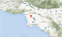
The United States Geological Survey recorded
a Magnitude 3.5 Earthquake at a depth of about 3 km beneath the Pacoima district of Los Angeles, California, slightly before 3.00 am
local time (slightly before 11.00 am GMT) on Thursday 5 November 2015. There are no reports of any damage or injuries relating to
this quake, but people have reported feeling it across much of the Los
Angeles area.

The approximate location of the 5 November 2015 Los Angeles Earthquake. Google Maps.
California
is extremely prone to Earthquakes due to the presence of the San
Andreas Fault, a tectonic plate margin that effectively bisects the
state. The west of California, including Santa Barbara and Los Angeles,
is located on the Pacific Plate, and is moving to the northwest. The
east of California, including Fresno and Bakersfield is on the North
American Plate, and is moving to the southeast. The plates do not move
smoothly past one-another, but constantly stick together then break
apart as the pressure builds up. This has led to a network of smaller
faults that criss-cross the state, so that Earthquakes can effectively
occur anywhere.

The extent of and movement on the San Andreas Fault. Geology.
Witness
accounts of Earthquakes can help geologists to understand these events,
and the structures that cause them. The international non-profit
organization Earthquake Report is interested in hearing from people who may have felt this event; if you felt this quake then you can report it to Earthquake Report here.
See also...
 Magnitude 3.4 Earthquake hits Los Angeles. The United States Geological Survey recorded
a Magnitude 3.4 Earthquake at a depth of about 12 km beneath the
Gardena district of Los Angeles, California, slightly before 10.00 pm
local time on Saturday 6...
Magnitude 3.4 Earthquake hits Los Angeles. The United States Geological Survey recorded
a Magnitude 3.4 Earthquake at a depth of about 12 km beneath the
Gardena district of Los Angeles, California, slightly before 10.00 pm
local time on Saturday 6... Magnitude 3.9 Earthquake off the coast of Long Beach, California. The United
States Geological Survey recorded a Magnitude 3.9 Earthquake at a depth
of about 1.1 km roughly 20 km off the coast of Long Beach...
Magnitude 3.9 Earthquake off the coast of Long Beach, California. The United
States Geological Survey recorded a Magnitude 3.9 Earthquake at a depth
of about 1.1 km roughly 20 km off the coast of Long Beach... Los Angeles shaken by Magnitude 4.4 Earthquake. The United States Geological Survey recorded a Magnitude 4.4 Earthquake
at a depth of 9.9 km, roughly 9 km to the northwest of Westwood, at
about 6.25 am...
Los Angeles shaken by Magnitude 4.4 Earthquake. The United States Geological Survey recorded a Magnitude 4.4 Earthquake
at a depth of 9.9 km, roughly 9 km to the northwest of Westwood, at
about 6.25 am...
Follow Sciency Thoughts on Facebook.