
The Japan Meteorological Agency recorded a Magnitude 6.1 Earthquake at a 'very shallow' depth about 50 km off the east coast of Kyūshū Island, slightly before 4.15 am Japan Standard Time on Friday 29 August 2014 (slightly before 7.15 pm on Thursday 28 August GMT). This is a large event, and closer to land would have been potentially very dangerous, but in this instance there are no reports of any damage or casualties.
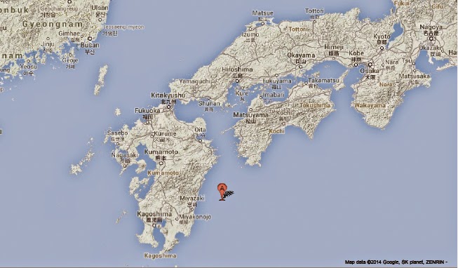
The approximate location of the 29 August 2014 Kyūshū Earthquake. Google Maps.
Japan has a complex tectonic environment with four plates underlying parts of the Islands; in addition to the Pacific in the east and the Othorsk in the North, there are the Philipine Plate to the south and the Eurasian Plate to the West. Kyūshū Island lies at the northeast end of the Ryukyu Island Arc, which sits on top of the boundary between the Eurasian and Philippine Plates. The Philippine Plate is being subducted beneath the Eurasian Plate, in the Ryukyo Trench, to the Southeast of the Islands. This is not a smooth process, with the two plates continuously sticking together then breaking apart as the presure builds up, leading to frequent Earthquakes in the region.

The movement of the Pacific and Philippine Plates beneath eastern Honshu. Laurent Jolivet/Institut des Sciences de la Terre d'Orléans/Sciences de la Terre et de l'Environnement.
See also...

On 20 December 2013 the Japan Meteorological Agency detected an increase in seismic activity beneath Aso (or Asosan) a volcanic caldera on central Kyūshū Island, Japan. This grew steadily for the next...

The Sakurajima Volcano, situated on an island in Kagoshima Bay, Kyushu, underwent a large explosive eruption on the morning of Friday 4 October 2013...

An eruption on Sakurajima Volcano, situated on an island in Kagoshima Bay, Kyushu, has coated the city...
Follow Sciency Thoughts on Facebook.