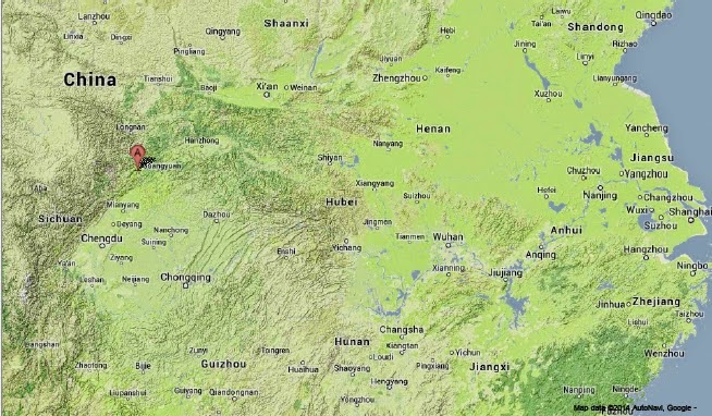
The China Earthquake Networks Center recorded a Magnitude 6.3 Earthquake in about 25 km to the northwest of Kanding in eastern Sichuan Province, slightly before 11.20 pm local time (slightly before 3.20 pm GMT) on Tuesday 25 November 2014. Five people are reported to have died as a result of the quake, with 54 more injured, six of whom ae described as being in critical conditions, and five more described as severly injured. The majority of the injuries are reported to have occured at a primary school in Tagong, close to the epicentre of the quake, where the event caused children to stampede. The Earthquke is also reported to have caused damage to around 25 000 homes. There have been several aftershocks since the original event.
Rescuers taking an injured man to hospital following the 25 November 2014 Sichuan Earthquake. Xinhua.
Much of western China and neighbouring areas of Central Asia and the
Himalayas, are prone to Earthquakes caused by the impact of the Indian
Plate into Eurasia from the south. The Indian Plate is moving northwards
at a rate of 5 cm per year, causing it to impact into Eurasia, which is
also moving northward, but only at a rate of 2 cm per year. When two
tectonic plates collide in this way and one or both are oceanic then one
will be subducted beneath the other (if one of the plates is
continental then the other will be subducted), but if both plates are
continental then subduction will not fully occur, but instead the plates
will crumple, leading to folding and uplift (and quite a lot of
Earthquakes). The collision of the Indian and Eurasian plates has lead
to the formation of the Himalayan Mountains, the Tibetan Plateau, and
the mountains of southwest China, Central Asia and the Hindu Kush.
The approximate location of the 25 November 2014 Sichuan Earthquake. Google Maps.
See also...
The United States Geological Survey
recorded a Magnitude 5.0 Earthquake at a depth of 18.5 km in Qingchuan
County in northern...
The United States Geological Survey recorded a Magnitude 4.7 Earthquake at a depth of 10.2 km, 109 km to the southwest of the...
The United States Geological Survey recorded a Magnitude 4.7 Earthquake at a depth of 28.6 km in the Liangshan Yi Autonomous...
Follow Sciency Thoughts on Facebook.


