
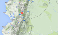
The United States Geological Survey recorded
a Magnitude 7.8 Earthquake at a depth of 19 km in coastal Esmeraldas
Province in northern Ecuador, slightly before 7.00 pm local time
(slightly after midnight GMT) on Saturday 16 April 2016. So far 272 people have been confirmed dead following the incident, the majority of them in Manabi Province, to the south of the epicenter. In addition over 2500 people have been reported injured, and many more are feared to be trapped in debris with collapsed buildings reported in six provinces. A tsunami warning was initially issued for coastal areas of Ecuador, Colombia, Costa Rica, Panama and Peru, though this was later lifted.

A collapsed building in Portoveijo in Manabi Province, Ecuador, following the 16 April 2016 Earthquake. Carlos Sacoto/AP.
Ecuador
is on the west coast of South America and the western margin of the
South American Plate, close to where the Nazca Plate, which underlies
part of the east Pacific, is being subducted along the Peru-Chile
Trench. The Nazca Plate passes under the South American Plate as it
sinks into the Earth, this is not a smooth process and the plates
repeatedly stick together then break apart as the pressure builds up,
causing Earthquakes. As the Nazca Plate sinks further it is melted by
the heat of the Earth's interior. Some of this melted material then
rises through the overlying South American Plate, fueling the volcanoes
of Ecuador and neighboring countries.

The subduction of the Nazca Plate beneath the South American Plate, and how it causes Earthquakes and volcanoes. SIO SEARCH.
Witness
accounts of Earthquakes can help geologists to understand these events,
and the structures that cause them. The international non-profit
organization Earthquake Report is interested in hearing from people who may have felt this event; if you felt this quake then you can report it to Earthquake Report here.
See also...
 Magnitude 5.4 Earthquake in Cañar Province, Ecuador. The United States Geological Survey recorded
a Magnitude 5.4 Earthquake at a depth of 104 km in northern Cañar
Province in southern Ecuador, at...
Magnitude 5.4 Earthquake in Cañar Province, Ecuador. The United States Geological Survey recorded
a Magnitude 5.4 Earthquake at a depth of 104 km in northern Cañar
Province in southern Ecuador, at... Eruptions on Cotopaxi The Instituto Geofísico-Escuela Politécnica Nacional reported
a series of eruptions on Cotopaxi, an active volcano in the Andes of
central Ecuador, about 50 km south of Quito, between Wednesday 7 and
Tuesday 13 October 2015, with ash columns rising up to 2.5 km above the
summit of the mountain and ash...
Eruptions on Cotopaxi The Instituto Geofísico-Escuela Politécnica Nacional reported
a series of eruptions on Cotopaxi, an active volcano in the Andes of
central Ecuador, about 50 km south of Quito, between Wednesday 7 and
Tuesday 13 October 2015, with ash columns rising up to 2.5 km above the
summit of the mountain and ash... Eruption on Wolf Volcano. At about 11.50 pm local time on
Sunday 24 May 2015 the Instituto Geofísico-Escuela Politécnica Nacional
recorded a sudden rise in seismic activity (Earthquakes) beneath Wolf Volcano,
which is located on the northern tip of Isabella Island in the...
Eruption on Wolf Volcano. At about 11.50 pm local time on
Sunday 24 May 2015 the Instituto Geofísico-Escuela Politécnica Nacional
recorded a sudden rise in seismic activity (Earthquakes) beneath Wolf Volcano,
which is located on the northern tip of Isabella Island in the...
Follow Sciency Thoughts on Facebook.