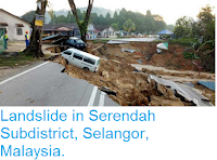
Thirteen families have been evacuated from their homes following a landslide at Tanah Rata in the Cameroon Highlands of Pahang State, Malaysia at about 3.15 pm local time on Sunday 25 December 2016. Nobody was injured in the event, though one home and a number of vehicles were damaged, and a number of trees brought down onto the Cameron Highlands-Tapah road; the other homes were evacuated as a precaution while the situation is assessed by engineers.
Damage following the 25 December 2016 Tanah Rata landslide. The Star.
The incident happened amid heavy rainfall in the area; landslides are a common problem after severe weather events,
as excess pore water pressure can overcome cohesion in soil and
sediments, allowing them to flow like liquids. Malaysia has become increasingly landslip-prone in recent years due to
extensive deforestation, which leaves soil exposed to heavy tropical
rainfall.
The approximate location of the 25 December 2016 Tanah Rata landslide. Google Maps.
Tanah Rata is situated in the Cameron Highlands at an altitude of about 1400 m, and has a cooler climate than lowland areas of Peninsula Malaysia, but still has a wet tropical climate with two distinct rainy seasons (common close to the equator, where the Sun is highest overhead around the equinoxes and lowest on the horizons around the solstices). These run from March to May and September to December, with peak rains in April, October and November. Late December is outside the peak rainy season, and is not usually considered a high risk for flooding and landslip events, however like other areas of Southeast Asia the rains have been particularly heavy this year, and have also persisted for longer, causing a string of natural disasters across the region.
See also...
Follow Sciency Thoughts on Facebook.


