Showing posts with label Bali. Show all posts

Sunday, 28 November 2021

Two tourists killed by landslide on Bali.

Two tourists have died following a landslide near the village of Kedewatan on southern Bali, Indonesia, on Thursday 25 November 2021. The pair, identified as Nuryanti, 36, and Julius Hans Wijaya, 10, both Indonesian nationals, were part of a group of Indonesian and Swedish tourists who had just taken part in a white-water rafting event, when the landslide hit. Both the victims were trapped beneath debris in soft mud; a third victim, 8-year-old Marvel Sanjaya, initially reported missing and feared to have also died, was later found safe. 

 
Rescue workers searching for victims following a landslide on Bali on 25 November 2021. Basarnas Bali/Coconuts.

The event is reported to have happened following a sudden heavy downpour. Landslides are a common problem after severe weather events, as excess pore water pressure can overcome cohesion in soil and sediments, allowing them to flow like liquids. Approximately 90% of all landslides are caused by heavy rainfall. November marks the onset of the rainy season on Bali, which lasts until April each year, driven by water laden winds from the South China Sea, associated with the Northeast Monsoon in Indonesia and Southeast Asia.

 
The winds that drive the Northeast and Southwest Monsoons in Southeast Asia. Mynewshub.

See also...


Follow Sciency Thoughts on Facebook.

Follow Sciency Thoughts on Twitter


Saturday, 25 May 2019

Flights cancelled after eruption on Mount Agung, Bali.

Flights to and from Bali have been halted following an eruption on Mount Agung, a 3000 m stratovolcano (cone shaped volcano made up of layers of ash and lava) on the eastern part of the island, on the evening of Friday 24 May 2019. The event lasted about four-and-a-half minutes, and threw incandescent rocks up to 3 km from the volcano, as well as causing ash falls in nearby communities. Volcanic ash is extremely hazardous to aircraft in a number of ways. At its most obvious it is opaque, both visually and to radar. Then it is abrasive, ash particles physically scour aircraft, damaging components and frosting windows. However the ash is most dangerous when it is sucked into jet engines, here the high temperatures can melt the tiny silica particles, forming volcanic glass which then clogs engine. When this happens the only hope the aircraft has is to dive sharply, in the hope that cold air passing through the engine during the descent will cause the glass to shatter, allowing the engine to be restarted. Obviously this is a procedure that pilots try to avoid having to perform. Despite this there has been no change to the volcano's alert status, with  the 4 km exclusion zone currently in place around the volcano thought to be sufficient.

 
Eruption on Mount Agung, Bali, on 24 May 2019. ABC News.

Mount Agung became active in September 2017, for the first time in over fifty years. This activity has caused considerable concern on the island, as when it last erupted in  1963-4, when it produced ash columns reaching 10 km above its 3 km high summit and lava flows that reached 7 km from the volcano, as well as triggering a series of lahars and pyroclastic flows that killed over 200 people, making people on the island very cautious about any future eruptions.

 The approximate location of Mount Agung. Google Maps.

The Indo-Australian Plate, which underlies the Indian Ocean to the south of Java, Bali and Lombok, is being subducted beneath the Sunda Plate, a breakaway part of the Eurasian Plate which underlies the islands and neighbouring Sumatra, along the Sunda Trench, passing under the islands, where friction between the two plates can cause Earthquakes. As the Indo-Australian Plate sinks further into the Earth it is partially melted and some of the melted material rises through the overlying Sunda Plate as magma, fuelling the volcanoes of Java and neighbouring islands.

 Subduction along the Sunda Trench beneath Java, Bali and Lombok. Earth Observatory of Singapore.

See also...

https://sciencythoughts.blogspot.com/2019/04/eruption-on-mount-agung-bali.htmlhttps://sciencythoughts.blogspot.com/2018/06/eruption-on-mount-agung-leads-to-flight.html
http://sciencythoughts.blogspot.com/2017/11/flights-to-and-from-bali-cancelled.htmlhttp://sciencythoughts.blogspot.com/2017/09/thousands-evacuated-from-area-around.html
http://sciencythoughts.blogspot.com/2017/03/magnitude-55-earthquake-beneath.htmlhttp://sciencythoughts.blogspot.com/2017/02/magnitude-46-earthquake-to-south-of.html
Follow Sciency Thoughts on Facebook.

Sunday, 21 April 2019

Eruption on Mount Agung, Bali.

Mount Agung, a 3000 m stratovolcano (cone shaped volcano made up of layers of ash and lava) on the eastern part of Bali, erupted suddenly at about 3.20 am local time on Sunday 21 April 2019, producing an ash column about 2 km high, and reports of ash falls in the Karangasem, Bangli and Klunglung districts of the island. Despite this there has been no change to the volcano's alert status, with the ash column dissipating to quickly to be considered a hazard to aviation, and the 4 km exclusion zone currently in place around the volcano thought to be sufficient, although there have been concerns about foreign tourists entering the exclusion zone to attempt to climb the mountain.

(Top) Explosions on Mount Agung at 3.22 am local time on 21 April 2019. (Middle) Ash coloum over the volcano at 3.25 am. (Bottom) Ash column at 3.30 am. Organisasi Daerah Bali/Youtube.

Mount Agung became active in September 2017, for the first time in over fifty years. This activity has caused considerable concern on the island, as when it last erupted in  1963-4, when it produced ash columns reaching 10 km above its 3 km high summit and lava flows that reached 7 km from the volcano, as well as triggering a series of lahars and pyroclastic flows that killed over 200 people, making people on the island very cautious about any future eruptions.

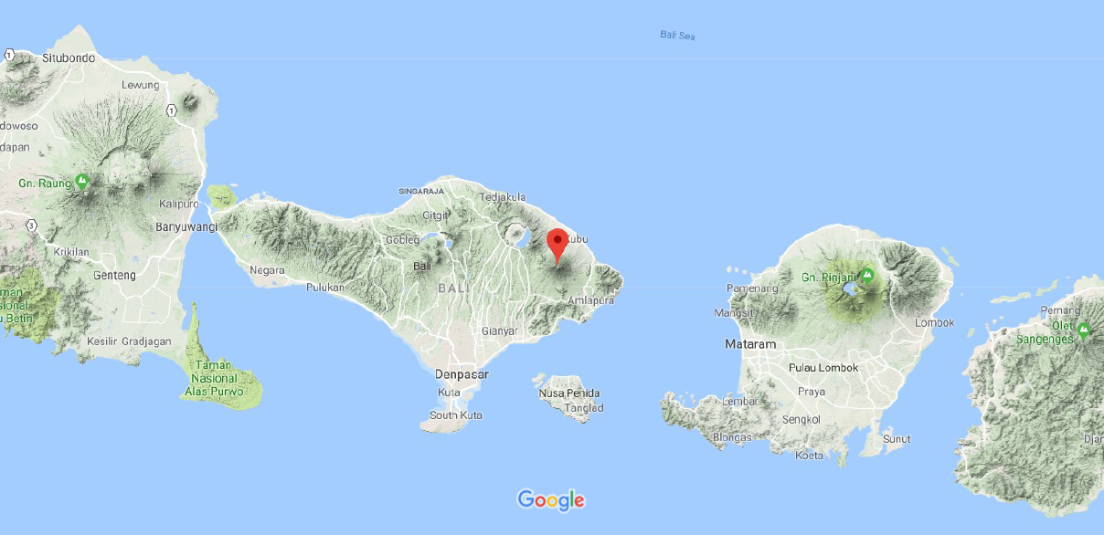
 The approximate location of Mount Agung. Google Maps.

The Indo-Australian Plate, which underlies the Indian Ocean to the south of Java, Bali and Lombok, is being subducted beneath the Sunda Plate, a breakaway part of the Eurasian Plate which underlies the islands and neighbouring Sumatra, along the Sunda Trench, passing under the islands, where friction between the two plates can cause Earthquakes. As the Indo-Australian Plate sinks further into the Earth it is partially melted and some of the melted material rises through the overlying Sunda Plate as magma, fuelling the volcanoes of Java and neighbouring islands.

 Subduction along the Sunda Trench beneath Java, Bali and Lombok. Earth Observatory of Singapore.

See also...
https://sciencythoughts.blogspot.com/2018/06/eruption-on-mount-agung-leads-to-flight.htmlhttp://sciencythoughts.blogspot.com/2017/11/flights-to-and-from-bali-cancelled.html
http://sciencythoughts.blogspot.com/2017/09/thousands-evacuated-from-area-around.htmlhttp://sciencythoughts.blogspot.com/2017/03/magnitude-55-earthquake-beneath.html
http://sciencythoughts.blogspot.com/2017/02/magnitude-46-earthquake-to-south-of.htmlhttp://sciencythoughts.blogspot.com/2017/02/landslides-kill-twelve-on-northern-bali.html
Follow Sciency Thoughts on Facebook.

Friday, 29 June 2018

Eruption on Mount Agung leads to flight cancellations to and from Bali.

Mount Agung, a 3000 m stratovolcano (cone shaped volcano made up of layers of ash and lava) on the eastern part of Bali, began erupting on Thursday 28 June 2018, producing a series of ash plumes over the next 24 hours which reached about 2.5 km above the summit of the volcano. The eruption led to the cancellation of a large number of flights to and from the island, due to the hazard presented to aircraft by volcanic ash, though flights did resume on the afternoon of Friday 29 June. Volcanic ash is extremely hazardous to aircraft in a number of ways. At its most obvious it is opaque, both visually and to radar. Then it is abrasive, ash particles physically scour aircraft, damaging components and frosting windows. However the ash is most dangerous when it is sucked into jet engines, here the high temperatures can melt the tiny silica particles, forming volcanic glass which then clogs engine. When this happens the only hope the aircraft has is to dive sharply, in the hope that cold air passing through the engine during the descent will cause the glass to shatter, allowing the engine to be restarted. Obviously this is a procedure that pilots try to avoid having to perform.

 Eruption on Mount Agung, Bali, on Thursday 28 June 2018. Johannes Christo/Reuters.

Mount Agung became active in September last year, for the first time in over fifty years. This activity has caused considerable concern on the island, as when it last erupted in  1963-4, when it produced ash columns reaching 10 km above its 3 km high summit and lava flows that reached 7 km from the volcano, as well as triggering a series of lahars and pyroclastic flows that killed over 200 people, making people on the island very cautious about any future eruptions.

The approximate location of Mount Agung. Google Maps.

The Indo-Australian Plate, which underlies the Indian Ocean to the south of Java, Bali and Lombok, is being subducted beneath the Sunda Plate, a breakaway part of the Eurasian Plate which underlies the islands and neighbouring Sumatra, along the Sunda Trench, passing under the islands, where friction between the two plates can cause Earthquakes. As the Indo-Australian Plate sinks further into the Earth it is partially melted and some of the melted material rises through the overlying Sunda Plate as magma, fuelling the volcanoes of Java and neighbouring islands.

 Subduction along the Sunda Trench beneath Java, Bali and Lombok. Earth Observatory of Singapore.

See also...

http://sciencythoughts.blogspot.com/2017/11/flights-to-and-from-bali-cancelled.htmlhttp://sciencythoughts.blogspot.com/2017/09/thousands-evacuated-from-area-around.html
http://sciencythoughts.blogspot.com/2017/03/magnitude-55-earthquake-beneath.htmlhttp://sciencythoughts.blogspot.com/2017/02/magnitude-46-earthquake-to-south-of.html
http://sciencythoughts.blogspot.com/2017/02/landslides-kill-twelve-on-northern-bali.htmlhttp://sciencythoughts.blogspot.com/2015/11/flights-cancelled-to-and-from-lombok.html
Follow Sciency Thoughts on Facebook.

Saturday, 25 November 2017

Flights to and from Bali cancelled following eruption on Mount Agung.

Several airlines have cancelled all flights to and from the island of Bali following an eruption on Mount Agung, a volcano on the eastern part of the island, on Tuesday 21 November 2017, which produced an ash column that rose 1.5 km above the 3 km summit of the mountain. Volcanic ash is extremely hazardous to aircraft in a number of ways. At its most obvious it is opaque, both visually and to radar. Then it is abrasive, ash particles physically scour aircraft, damaging components and frosting windows. However the ash is most dangerous when it is sucked into jet engines, here the high temperatures can melt the tiny silica particles, forming volcanic glass which then clogs engine. When this happens the only hope the aircraft has is to dive sharply, in the hope that cold air passing through the engine during the descent will cause the glass to shatter, allowing the engine to be restarted. Obviously this is a procedure that pilots try to avoid having to perform.

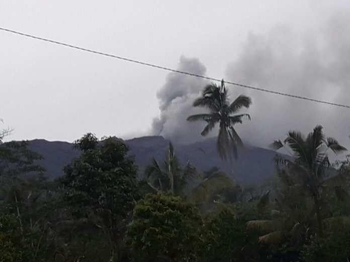
 An ash column over Mount Agung, Bali, earlier this week. Baliberkarya.

Mount Agung became active in September this year, for the first time in over fifty years. This activity has caused considerable concern on the island, as when it last erupted in  1963-4, when it produced ash columns reaching 10 km above its 3 km high summit and lava flows that reached 7 km from the volcano, as well as triggering a series of lahars and pyroclastic flows that killed over 200 people, making people on the island very cautious about any future eruptions.

The approximate location of Mount Agung. Google Maps.

The Indo-Australian Plate, which underlies the Indian Ocean to the south of Java, Bali and Lombok, is being subducted beneath the Sunda Plate, a breakaway part of the Eurasian Plate which underlies the islands and neighbouring Sumatra, along the Sunda Trench, passing under the islands, where friction between the two plates can cause Earthquakes. As the Indo-Australian Plate sinks further into the Earth it is partially melted and some of the melted material rises through the overlying Sunda Plate as magma, fuelling the volcanoes of Java and neighbouring islands.

 Subduction along the Sunda Trench beneath Java, Bali and Lombok. Earth Observatory of Singapore.

See also...

http://sciencythoughts.blogspot.co.uk/2017/09/thousands-evacuated-from-area-around.htmlhttp://sciencythoughts.blogspot.co.uk/2017/03/magnitude-55-earthquake-beneath.html
http://sciencythoughts.blogspot.co.uk/2017/02/magnitude-46-earthquake-to-south-of.htmlhttp://sciencythoughts.blogspot.co.uk/2017/02/landslides-kill-twelve-on-northern-bali.html
http://sciencythoughts.blogspot.co.uk/2015/11/flights-cancelled-to-and-from-lombok.htmlhttp://sciencythoughts.blogspot.co.uk/2012/09/large-earthquake-to-south-of-east-java.html
Follow Sciency Thoughts on Facebook.