Showing posts with label Aircraft safety. Show all posts

Sunday, 21 May 2023

Eruption on Mount Popocatépetl closes airports in Mexico City.

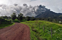
An eruption on Mount Popocatépetl led to a major ashfall affecting Mexico City in the early hours of Saturday 20 May 2023, which in turn closed the city's two airports to close. Volcanic ash is extremely hazardous to aircraft in a number of ways. At its most obvious it is opaque, both visually and to radar. Then it is abrasive, ash particles physically scour aircraft, damaging components and frosting windows. However, the ash is most dangerous when it is sucked into jet engines, here the high temperatures can melt the tiny silica particles, forming volcanic glass which then clogs engine. When this happens the only hope the aircraft has is to dive sharply, in the hope that cold air passing through the engine during the descent will cause the glass to shatter, allowing the engine to be restarted. Obviously, this is a procedure that pilots try to avoid having to perform. Communities closer to the volcano were also affected by the ashfall, with eleven schools being closed as a precaution due to poor air quality, although there are no reports of any damage or casualties.

An eruption on Mount Popocatépetl slightly before midnight on Friday 19 May 2023. Webcams de Mexico.

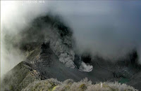
Popocatépetl has been more or less constantly erupting since the mid 1990s, but most of the time this activity remains at a low level. Major eruptions on Popocatépetl are a cause for concern as the volcano is in a densely populated area, with 30 million people living within the potential hazard zone. The last major eruption, a Plinian (or Vesuvian) event in about 800 AD, triggered a series of pyroclastic flows and lahars that scoured the basins around the volcano.

The location of Mount Popocatépetl. Google Maps.

The volcanoes of the Trans-Mexican Volcanic Belt (including Popocatépetl) are fuelled by the subduction of the Cocos Plate beneath the North American Plate along the Middle American Trench to the south of Mexico. As the subducting plate sinks into the Earth it is melted by the heat and pressure, and volatile minerals liquefy and rise through the overlying North American Plate as magma, fueling Mexico's volcanoes. 

The subduction of the Cocos Plate beneath the North American Plate in Mexico, and how it leads to volcanoes and Earthquakes. 

The Cocos Plate is thought to have formed about 23 million years ago, when the Farallon Plate, an ancient tectonic plate underlying the East Pacific, split in two, forming the Cocos Plate to the north and the Nazca Plate to the south. Then, roughly 10 million years ago, the northwesternmost part of the Cocos Plate split of to form the Rivera Plate, south of Beja California.

The position of the Cocos, Nazca and Rivera Plates. MCEER/University at Buffalo.

In a paper published in the Journal of Geophysical Research: Solid Earth, in 2011, a team led by Igor Stubailo of the Department of Earth and Space Sciences at the University of California Los Angeles, published a model of the subduction zone beneath Mexico using data from seismic monitoring stations belonging to the Mesoamerican Seismic Experiment, the Network of Autonomously Recording Seismographs, the USArray, Mapping the Rivera Subduction Zone and the Mexican Servicio Sismologico Nacional.
 
The seismic monitoring stations were able to monitor not just Earthquakes in Mexico, but also Earthquakes in other parts of the world, monitoring the rate at which compression waves from these quakes moved through the rocks beneath Mexico, and how the structure of the rocks altered the movement of these waves.

Based upon the results from these monitoring stations, Stubailo et al. came to the conclusion that the Cocos Plate was split into two beneath Mexico, and that the two plates are subducting at different angles, one steep and one shallow. Since the rate at which a plate melts reflects its depth within the Earth, the steeper angled plate melts much closer to the subduction zone than the shallower angled plate, splitting the Trans-Mexican Volcanic Belt into sections above the different segments of the Cocos Plate, and causing it to apparently curve away from the subduction zone.

Top the new model of the Cocos Plate beneath Mexico, split into two sections (A & B) subducting at differing angles. (C) Represents the Rivera Plate, subducting at a steeper angle than either section of the Cocos Plate. The Split between the two has been named the Orozco Fracture Zone (OFZ) which is shown extended across the Cocos Plate; in theory this might in future split the Cocos Plate into two segments (though not on any human timescale). Bottom Left, the position of the segments on a map of Mexico. Darker area is the Trans-Mexican Volcanic Belt, orange circles are volcanoes, brown triangles are seismic monitoring stations, yellow stars are major cities. Bottom Right, an alternative model showing the subducting plate twisted but not split. This did not fit the data. Stubailo et al. (2012).

See also...

Follow Sciency Thoughts on Facebook.

Follow Sciency Thoughts on Twitter.


Monday, 2 January 2023

Four presumed dead following helicopter crash in the Gulf of Mexico.

The US Coast Guard has called off a search for survivors, following a helicopter crash in the Gulf of Mexico. The helicopter, operated by Rotorcraft Leasing, crashed while taking off from a Walter Oil & Gas owned offshore oil platform, about 16 km to the south of the mouth of the Southwest Pass of the Mississippi River, at about 8.40 am local time on Thursday 29 December 2022. It is reported to have struck the landing pad as it took off, and subsequently to have fallen into the water.

Debris from a helicopter crash on 29 December 2022 next to a Walter Oil & Gas owned offshore oil platform 16 km off the coast of Louisiana. US Coast Guard.

Following an extensive search by helicopter and small boat, which discovered debris from the crash but no signs of the missing pilot or three passengers, the search was called off at 6.15 pm the same day. One of the passengers has been named as David Scarborough (36), from Lizana, Mississippi, who was returning to shore following a two week shift on the oil platform. Scarborough is survived by his wife, Lacy, and a two-year-old son, Sawyer; the couple were expecting a second child in April. The other victims of the crash have not yet been named.

David Scarborough (36), from Lizana, Mississippi, believed to have died in a helicopter crash in the Gulf of Mexico on 29 December 2022. Lacy Scarborough/Sun Herald.

This is the second crash by a Rotocraft Leasing helicopter attended by the US Coast Guard within two weeks; the first incident happened on 15 December when a helicopter with three people on board went down 25 km off the coast of Terrebonne Bay, while attempting to land on an oil platform. On that occasion all three people on board were able to escape into an inflatable raft, and were subsequently airlifted to hospital with back injuries. 

The US Coast Guard also airlifted two workers from offshore oil vessels in the Gulf of Mexico to hospital in December, both also with back injuries, as well as dealing with two separate oil spill incidents.

See also...

Follow Sciency Thoughts on Facebook.

Follow Sciency Thoughts on Twitter.


Wednesday, 16 October 2019

Eruption on the Metis Shoal underwater volcano.

The Tonga Meteorological Service has issued a warning to aviation following an eruption on Metis Shoal, a submarine volcano between the islands of Koa and Late, on Tuesday 15 October 2019. The volcano began erupting at about 8.30 am local time, producing a column of ash between 4500 and 5000 m high. Volcanic ash is extremely hazardous to aircraft in a number of ways. At its most obvious it is opaque, both visually and to radar. Then it is abrasive, ash particles physically scour aircraft, damaging components and frosting windows. However the ash is most dangerous when it is sucked into jet engines, here the high temperatures can melt the tiny silica particles, forming volcanic glass which then clogs engine. When this happens the only hope the aircraft has is to dive sharply, in the hope that cold air passing through the engine during the descent will cause the glass to shatter, allowing the engine to be restarted. Obviously this is a procedure that pilots try to avoid having to perform.

 An ash column over Metis Shoal, Tonga, on 15 October 2019. Samuela Folaumoetu'i/Real Tonga Airlines.

Metis Shoal is a growing submarine volcano which is (most of the time) slightly below the sea surface. However it has been producing small dome islands following eruptions since at least the 1780s, and while these have, to date, all washed away afterwards, it is likely that one day the volcano will grow into a true volcanic island.

(Top) An exposed island in Metis Shoal in December 2006. Royal New Zealand Air Force/Institute of Geological & Nuclear Sciences/Smithsonian Global Volcanism Program. (Bottom) Waves breaking over the shoal in February 1968, showing the position of an island that appeared in December 1967 then eroded away. Charles Lundquist/Smithsonian Astrophysical Observatory/Smithsonian Global Volcanism Program.

The islands of Tonga lie along the boundary between the Pacific and Australian Tectonic Plates. The Pacific Plate is being subducted beneath the Australian Plate along the Tonga Trench, which forms the boundary between these two plates, with the volcanic islands that make up the archipelago being formed as the subducting plate is melted by the heat of the planet's interior, so that lighter minerals rise up through the overlying plate as liquid magma, which fuels the volcanoes that build the islands.

 Diagram showing subduction along the Tonga Trench, and how this feeds the volcanoes of the Tonga Volcanic Arc. York University.

See also...

https://sciencythoughts.blogspot.com/2019/08/large-pumice-raft-observed-floating.htmlhttps://sciencythoughts.blogspot.com/2019/06/magnitude-59-earthquake-to-east-of-eua.html
https://sciencythoughts.blogspot.com/2018/02/cyclone-gita-reaches-new-zealand.htmlhttps://sciencythoughts.blogspot.com/2017/11/magnitude-68-earthquake-between-tonga.html
https://sciencythoughts.blogspot.com/2015/07/magnitude-62-earthquake-to-northeast-of.htmlhttps://sciencythoughts.blogspot.com/2015/01/eruption-on-hunga-haapai.html


Follow Sciency Thoughts on Facebook.

Friday, 29 June 2018

Eruption on Mount Agung leads to flight cancellations to and from Bali.

Mount Agung, a 3000 m stratovolcano (cone shaped volcano made up of layers of ash and lava) on the eastern part of Bali, began erupting on Thursday 28 June 2018, producing a series of ash plumes over the next 24 hours which reached about 2.5 km above the summit of the volcano. The eruption led to the cancellation of a large number of flights to and from the island, due to the hazard presented to aircraft by volcanic ash, though flights did resume on the afternoon of Friday 29 June. Volcanic ash is extremely hazardous to aircraft in a number of ways. At its most obvious it is opaque, both visually and to radar. Then it is abrasive, ash particles physically scour aircraft, damaging components and frosting windows. However the ash is most dangerous when it is sucked into jet engines, here the high temperatures can melt the tiny silica particles, forming volcanic glass which then clogs engine. When this happens the only hope the aircraft has is to dive sharply, in the hope that cold air passing through the engine during the descent will cause the glass to shatter, allowing the engine to be restarted. Obviously this is a procedure that pilots try to avoid having to perform.

 Eruption on Mount Agung, Bali, on Thursday 28 June 2018. Johannes Christo/Reuters.

Mount Agung became active in September last year, for the first time in over fifty years. This activity has caused considerable concern on the island, as when it last erupted in  1963-4, when it produced ash columns reaching 10 km above its 3 km high summit and lava flows that reached 7 km from the volcano, as well as triggering a series of lahars and pyroclastic flows that killed over 200 people, making people on the island very cautious about any future eruptions.

The approximate location of Mount Agung. Google Maps.

The Indo-Australian Plate, which underlies the Indian Ocean to the south of Java, Bali and Lombok, is being subducted beneath the Sunda Plate, a breakaway part of the Eurasian Plate which underlies the islands and neighbouring Sumatra, along the Sunda Trench, passing under the islands, where friction between the two plates can cause Earthquakes. As the Indo-Australian Plate sinks further into the Earth it is partially melted and some of the melted material rises through the overlying Sunda Plate as magma, fuelling the volcanoes of Java and neighbouring islands.

 Subduction along the Sunda Trench beneath Java, Bali and Lombok. Earth Observatory of Singapore.

See also...

http://sciencythoughts.blogspot.com/2017/11/flights-to-and-from-bali-cancelled.htmlhttp://sciencythoughts.blogspot.com/2017/09/thousands-evacuated-from-area-around.html
http://sciencythoughts.blogspot.com/2017/03/magnitude-55-earthquake-beneath.htmlhttp://sciencythoughts.blogspot.com/2017/02/magnitude-46-earthquake-to-south-of.html
http://sciencythoughts.blogspot.com/2017/02/landslides-kill-twelve-on-northern-bali.htmlhttp://sciencythoughts.blogspot.com/2015/11/flights-cancelled-to-and-from-lombok.html
Follow Sciency Thoughts on Facebook.

Saturday, 25 November 2017

Flights to and from Bali cancelled following eruption on Mount Agung.

Several airlines have cancelled all flights to and from the island of Bali following an eruption on Mount Agung, a volcano on the eastern part of the island, on Tuesday 21 November 2017, which produced an ash column that rose 1.5 km above the 3 km summit of the mountain. Volcanic ash is extremely hazardous to aircraft in a number of ways. At its most obvious it is opaque, both visually and to radar. Then it is abrasive, ash particles physically scour aircraft, damaging components and frosting windows. However the ash is most dangerous when it is sucked into jet engines, here the high temperatures can melt the tiny silica particles, forming volcanic glass which then clogs engine. When this happens the only hope the aircraft has is to dive sharply, in the hope that cold air passing through the engine during the descent will cause the glass to shatter, allowing the engine to be restarted. Obviously this is a procedure that pilots try to avoid having to perform.

 An ash column over Mount Agung, Bali, earlier this week. Baliberkarya.

Mount Agung became active in September this year, for the first time in over fifty years. This activity has caused considerable concern on the island, as when it last erupted in  1963-4, when it produced ash columns reaching 10 km above its 3 km high summit and lava flows that reached 7 km from the volcano, as well as triggering a series of lahars and pyroclastic flows that killed over 200 people, making people on the island very cautious about any future eruptions.

The approximate location of Mount Agung. Google Maps.

The Indo-Australian Plate, which underlies the Indian Ocean to the south of Java, Bali and Lombok, is being subducted beneath the Sunda Plate, a breakaway part of the Eurasian Plate which underlies the islands and neighbouring Sumatra, along the Sunda Trench, passing under the islands, where friction between the two plates can cause Earthquakes. As the Indo-Australian Plate sinks further into the Earth it is partially melted and some of the melted material rises through the overlying Sunda Plate as magma, fuelling the volcanoes of Java and neighbouring islands.

 Subduction along the Sunda Trench beneath Java, Bali and Lombok. Earth Observatory of Singapore.

See also...

http://sciencythoughts.blogspot.co.uk/2017/09/thousands-evacuated-from-area-around.htmlhttp://sciencythoughts.blogspot.co.uk/2017/03/magnitude-55-earthquake-beneath.html
http://sciencythoughts.blogspot.co.uk/2017/02/magnitude-46-earthquake-to-south-of.htmlhttp://sciencythoughts.blogspot.co.uk/2017/02/landslides-kill-twelve-on-northern-bali.html
http://sciencythoughts.blogspot.co.uk/2015/11/flights-cancelled-to-and-from-lombok.htmlhttp://sciencythoughts.blogspot.co.uk/2012/09/large-earthquake-to-south-of-east-java.html
Follow Sciency Thoughts on Facebook.

Wednesday, 21 September 2016

Airports closed after eruptions on Mount Turrialba.

Several airports in Costa Rica were forced to close after a pair of eruptions on Mount Turrialba, a stratovolcano (cone shaped volcano made up of layers of ash and lava) in the central part of the country, Monday 19 September 2016. The first eruption occured at about dawn, the second at about noon, this latter event producing an ash column over four kilometers high, and causing ashfalls in the city of Cartago. A third eruption occured on Tuesday 20 September.

Eruption on Mount Turrialba on Monday 19 September 2016. Red Sismológica Nacional/Universidad de Costa Rica.

Volcanic ash is extremely hazardous to aircraft in a number of ways. At its most obvious it is opaque, both visually and to radar. Then it is abrasive, ash particles physically scour aircraft, damaging components and frosting windows. However the ash is most dangerous when it is sucked into jet engines, here the high temperatures can melt the tiny silica particles, forming volcanic glass which then clogs engine. When this happens the only hope the aircraft has is to dive sharply, in the hope that cold air passing through the engine during the descent will cause the glass to shatter, allowing the engine to be restarted.

 Residents of Cartago during an ashfall event on Monday 19 September 2016. AFP.

Turrialba forms part of the Cordillera Central, a range of volcanic mountains running through central Costa Rica and forming part of the Central American Arc. These volcanoes are fueled by the subduction of the Cocos Plate, which underlies part of the east Pacific Ocean, beneath the Caribbean Plate, on which Central America lies, along the Middle American Trench, which lies off the south coast of the country. As the Cocos Plate is subducted it is gradually melted by the heat and pressure of the Earth's interior, with some more volatile minerals rising through the overlying Caribbean Plate as volcanic magma.

  Diagram showing the passage of the Cocos Plate beneath Costa Rica (not to scale). Carleton College.

See also...

http://sciencythoughts.blogspot.co.uk/2016/05/exclusion-zone-established-around-mount.htmlExclusion zone established around Mount Turriabla after a series of eruptions on Sunday 1 May 2016.                                    The Costa Rican Comisión Nacional de Emergencias has...
http://sciencythoughts.blogspot.co.uk/2016/05/eruptions-on-mount-turrialba.htmlEruptions on Mount Turrialba                         The Observatorio Vulcanológico y Sismológico de Costa Rica-Universidad Nacional reported a series of eruptions on Mount Turrialba, a stratovolcano (cone shaped volcano made up of layers of ash and lava) in the central part of...
http://sciencythoughts.blogspot.co.uk/2015/12/explosive-eruption-on-mount-turrialba.htmlExplosive eruption on Mount Turrialba. The Observatorio Vulcanológico y Sismológico de Costa Rica-Universidad Nacional reported a short explosive eruption which lasted about ten minutes, beginning slightly after 1.10 pm local time on Monday 7 December 2015...
 
Follow Sciency Thoughts on Facebook.