The Indonesian Meteorological, Climatological, and Geophysical Agency recorded a Magnitude 6.2 Earthquake at a depth of about 29 km, off the West coast of Aceh Province, Sumatra, Indonesia slightly after 6.00 pm Western Indonesian Time (slightly after 11.00 am GMT) on Tuesday 31 January 2025. There have been no reports of any damage or casualties following this event, but people have reported feeling tremors across Aceh Province and parts of North Sumatra.

The approximate location of the 31 January 2025 Aceh Province Earthquake. USGS.
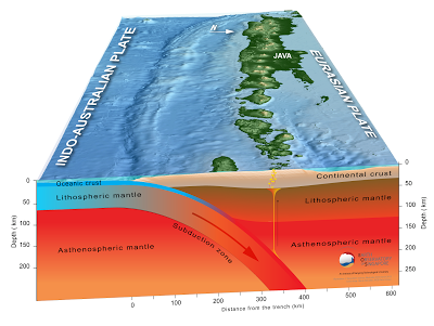
The Indo-Australian Plate, which underlies the Indian Ocean to the west of Sumatra, is being subducted beneath the Sunda Plate, a breakaway part of the Eurasian Plate which underlies Sumatra and neighbouring Java, along the Sunda Trench, passing under Sumatra, where friction between the two plates can cause Earthquakes. As the Indo-Australian Plate sinks further into the Earth it is partially melted and some of the melted material rises through the overlying Sunda Plate as magma, fueling the volcanoes of Sumatra.

The Subduction zone beneath Sumatra. NASA/Earth Observatory.
This does not happen at a 90° angle, as occurs in the subduction zones along the western margins of North and South America, but at a steeply oblique angle. This means that as well as the subduction of the Indo-Australian plate beneath the Sunda, the two plates are also moving past one-another. This causes rifting within the plates, as parts of each plate become stuck to the other, and are dragged along in the opposing plate's direction. The most obvious example of this is the Sumatran Fault, which runs the length of Sumatra, with the two halves of the island moving independently of one-another. This fault is the cause of most of the quakes on the island, and most of the island's volcanoes lie on it.

The movement of the tectonic plates around Sumatra. NASA/Earth Observatory.
See also...

.jpg)
.jpg)