Showing posts with label Bronze Age. Show all posts

Saturday, 15 June 2024

Archeologists uncover mysterious Minoan structure on the Greek island of Crete.

Archaeologists on the Greek island of Crete carrying out survey work ahead of the construction of a new airport have uncovered a mysterious structure believed to date from the Late Palaeopalatial Period of the ancient Minoan civilization, according to a press release issued by the Greek Ministry of Culture on 11 June 2024.  The excavation work was being carried out on Papoura Hill on the eastern part of the island, where it was planned to build radar station to serve the new airport, though the significance of the discovery means that serious consideration is now being given as to whether this part of the project can go ahead as planned.

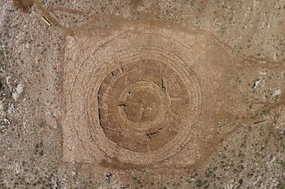
The new monumental structure discovered on Papoura Hill, Crete. Greek Ministry of Education.

The structure is believed to have been constructed between about 2000 and 1700 BC, and to have remained in use for several hundred years. It comprises a series of stone rings, which are on average 1.4 m thick, and rise a maximum of 1.7 m above the surroundings. The outer diameter of this structure is about 48 m, with what appears to have been a circular building 15 m in diameter at the centre. This building had entrances on the northwest and southwest parts of its diameter. The area surrounding the structure has produced thousands of Animal bones, suggesting that the site was used for ritual feasting.

The new Minoan structure seen from above. Greek Ministry of Culture.

No similar structure has been found at any Minoan site, despite many decades of intensive study of the culture, emphasising the uniqueness of the site. Possible similarities to structures at the Mycenaean site of Tiryns in the Peloponnese, or the elliptical Middle Minoan house at Hamezion on eastern Crete, although investigations at the site are still at an early stage.

See also...

Thursday, 30 May 2024

English museum aquires Bronze Age Hoard.

The Dorset Museum and Art Gallery in southern England has raised £17 000 needed to acquire a Bronze Age hoard discovered by a metal detectorist in 2020. The hoard, which comprises a sword, and axe head, and a bracelet, was found by metal detectorist John Belgrave during an organised event at a farm in the village of Stalbridge, near Sherborne in Dorset, during an organised event, when he became separated from the group and climbed a hill outside the planned area of the survey, where he made the discovery. The £17 000 will be divided between Belgrave and the owner of the land where the discovery was made.

Middle Bronze Age rapier, a bangle and palstave axe head. Portable Antiquities Scheme/British Museum/Surry County Council.

The sword from the Stalbridge Middle Bronze Age Hoard is a bronze rapier with a blade 535 mm in length, cast in one piece, but apparently deliberately broken into the sections, one of which is still attached to the hilt, before being buried. The hilt of the sword is made from a copper alloy, and has been cast in the form of the wooden sword hilts typical of the time. The blade is cross shaped in profile, 60 mm wide and 7.5 mm thick at the hilt. The longer of the two blade fragments is bent, and weighs 188 g, the smaller weighs 23.34 g. The hilt is 113 mm long, with an ovel pommel measuring 46.2 mm by 41.6 mm. The guard is c-shaped, with the bade of the blade still attached by four dome-headed rivets. Swords of this type have been referred to as Wandsworth-type rapiers, and are associated with the Middle Bronze Age Taunton Phase, between about 1400 and 1275 BC.

Metal detectorist John Belgrave with the sword he found in Stalbridge, Dorset, in 2020. Max Willcock/Bournemouth News & Picture Service.

The bronze axe-head is of a type called a South-western palstave, also associated with the Taunton Phase. These have a side-loop, a mid-rib, and side-flanges which would have been used to support a forked wooden handle. It is made from a copper-alloy, and is 159 mm in length with a maximum thickness of 31.5 mm. The cutting edge of the axe flares to give a rounded cutting edge, 51.7 mm wide.

A palstave axe-head found in Dorset in 2020. Portable Antiquities Scheme/British Museum/Surry County Council.

The bracelet is a copper-alloy ring-shaped bangle, of a type known as a Liss Bracelet, again associated with the Taunton Phase. It has an outer diameter of 75.6 mm, an inner diameter of 61.5 mm, a width of 16.3 mm, and a width that varies between 6.1 and 6.8mm. Its outer surface has an incised or engraved panels which with complex geometric decoration, which appears to be centred on a thickened lobe on one side. Liss Bracelets are known only from the Taunton Phase of the English Bronze Age, with most known examples coming from Hampshire, Wiltshire, Dorset, and West Sussex, though they have also been found in Norfolk and Suffolk. 

A Liss Bracelet from the Stalbridge Middle Bronze Age Hoard. Portable Antiquities Scheme/British Museum/Surry County Council.

See also...

Sunday, 12 May 2024

Bronze Age well uncovered in Oxfordshire, England.

Archaeologists from Oxford Archaeology carrying out work for Oxfordshire County Council have uncovered a Bronze Age well in the southeast of the county, according to a press release issued on 7 May 2024. The archaeologists were carrying out surveying work ahead of the construction of a new road, north of the village of Benson when the well was discovered.

A Bronze  Age well discovered near the village of Benson in Oxfordshire, England. Oxfordshire County Council.

The well is lined with wooden wattle, and is thought to date from the Late Bronze Age, with a more precise date likely to be obtained through radiocarbon dating. The structure was recorded digitally, before being carefully dismantled and removed for storage by the Oxfordshire Museum Service (left in place it would have been destroyed by the road construction work). It is hoped that testing of the materials will enable archaeologists to determine the type of wood used to construct the well, as well as the tools and techniques used to work the wood. Preserved wooden items of this age are extremely rare, and in this case have probably survived because the environment was waterlogged, and the well was filled in. Traces of Bronze Age activity have previously been found around Benson, and it is hoped that soil samples taken from within the well will provide information about the local environment during the period.

See also...

Wednesday, 28 February 2024

Bronze Age metalworks found in northern Oman.

Archaeologists from the Polish Centre of Mediterranean Archaeology at the University of Warsaw have unearthed evidence of Bronze Age metalworking during exploratory work in the Qumayrah Valley of northern Oman. The team, who have been working in Oman since 2016, spent five weeks in the area in November and December 2024, uncovering about 50 structures associated with the Bronze Age Umm an-Nar and Wadi Suq cultures, as well as a smaller amount of Iron Age and later material, according to a press release issued on 12 February 2024.

The approximate location of the Qumayrah Valley in northern Oman. Google Maps.

The oldest structures found date to the Early Bronze Age Umm an-Nar Culture, which is thought to have lasted from about 2600 BC to about 2000 BC, and include round stone towers at the Ajran 1 and QB 6 localities, and a number of tower tombs at Ajran 4. This period appears to have seen a significant economic boom in the region, leading to a rise in population, and more archaeological remains being left behind than in subsequent periods.

Reconnaissance at site QB 6, where the remains of a round tower building made of white limestone were found. Agnieszka Szymczak/Polish Centre of Mediterranean Archaeology.

This Umm an-Nar economic boom is thought to have been driven by long distance trade with India and Mesopotamia, with the main export from Oman being copper. Because of this, the Polish team have been searching for signs of copper working in the Qumayrah Valley. The discoveries made this season include a complex of sites around Wadi Salh, which include slag fields up to 220 m by 50 m and 25 cm to 50 cm thick, along with dozens of stone tools thought to have been used for crushing ore, and the remains of numerous furnaces. Several buildings thought to have been used as workshops have also been identified.

A slag field in Wadi Salh; flags mark stone tools for crushing ore. Agnieszka Szymczak/Polish Centre of Mediterranean Archaeology.

Iron Age remains are much less common in the region, but the team did find a site, QA 20, where what appears to have been an Iron Age observation tower and accompanying settlement was located at the intersection of two valleys. The settlement, thought to have dated to between 1100 BC and 600 BC, comprised a dense arrangement of adjoining houses on either side of a narrow street. Thirty three rooms have been excavated so far at this site, covering an area of about 1400 m².

Representatives of the local community, teachers and students from schools in the village of Qumayrah with members of the Omani-Polish expedition at the QA 20 site. Olga Puszkarewicz/Polish Centre of Mediterranean Archaeology.

See also...

Sunday, 18 February 2024

Understanding the orientation of graves in the Bronze Age Gumugou Cemetery of Xinjiang Province, China.

Many cultures bury their dead with a preferred orientation, and understanding how this is chosen can tell us a great deal about the beliefs of a culture. The orientation of graves has been extensively studied for ancient European and Mediterranean cultures, demonstrating that burials were often aligned with both terrestrial and celestial objects of importance by ancient peoples, but has been less well studied in other parts of the world.

In a paper published in the Journal of Archaeological Science: Reports on 17 February 2024, Jingjing Li of the Xinjiang Astronomical Observatory, Jarken Esimbek, also of the Xinjiang Astronomical Observatory, and of the University of the Chinese Academy of Sciences, and Yingxiu Ma, again of the Xinjiang Astronomical Observatory, examine the orientation of graves in the Bronze Age Gumugou Cemetery of Xinjiang Province, China.

The Gumugou Cemetery is located on the eastern fringe of the Taklimakan Desert, in the Tarim Basin, to the north of the now dry Kongque (Peacock) River and about 70 km to the west of the Lop Nor Salt Lake. The cemetery has been dated to between 3800 and 3400 years before the present, and along with a series of related sites within the region between Lop Nor and the Taklimakan Desert, is considered representative of one of the oldest known Bronze Age cultures within Xinjiang Province.

Location of the Gumugou Cemetery and other archaeology sites in the Tarim Basin, Xinjiang. Li et al. (2024).

The Gumugou Cemetery site was excavated in the winter of 1979 by an expedition from the Xinjiang Institute of Archaeology under the leadership of Binghua Wang. A total of 42 burials were discovered and excavated, all within an area of 1600 m³. The burials could be divided into two types, with six Type I burials forming an upper layer, and 36 Type II burials forming a lower layer. 

The Type I burials are quite often placed above Type II burials, and are surrounded by seven rounds of timber posts. These Type I burials apparently contained wooded coffins, which have long decayed away, leaving the (well preserved) Human remains exposed. A small amount of grave goods were present. 

Surface of Type I burials of the Gumugou site. Li et al. (2024).

Type II burials form a lower layer and each contain a single body placed within a boat-shaped coffin between two posts, one at the head of the coffin and one at the feet. These contained more numerous grave goods, including pointed felt hats, leather, woollen capes, grass woven baskets, bone and stone artifacts, wheat grains, and Ephedra twigs. While grave goods were more numerous in the Type II burials than the Type I burials, there was otherwise little to differentiate them, and they are presumed to have come from the same culture.

Part of Type II burials of Gumugou Cemetery. Binghua Wang in Li et al. (2024).

The tombs are aligned roughly along an east-west axis, with their heads to the east, which, combined with the posts surrounding the Type I burials, which resemble solar rays, was taken as evidence of sun-worship by the people who used the cemetery.

However, Wang took care to record every detail about the graves, including the azimuth of each burial (the azimuth is an orientation relative to true north, where north is 0°, east is 90°, south is 180°, etc.). Li et al. collated this data, and compared it to a calculated solar arc for sunrises at the site. A solar arc of sunrises is made up of the azimuth of the sunrise throughout the year, giving an arc (in the Northern Hemisphere) with the Summer Solstice to the north and the Winter Solstice to the south. At the Gumugou Cemetery the sunrise azimuth is 57.7° on the summer solstice and 120.8° on the winter solstice, while the graves have azimuths of between 102° and 58°.

Orientations of the grave in Gumugou cemetery. Li et al. (2024).

The region where the Gumugou Cemetery is located has an arid desert climate with temperatures reaching as high as 40°C in the summer and falling as low as -20°C in the winter, and strong winds in spring and autumn leading to dust storms which can cause potentially lethal respiratory illnesses. The graves in the cemetery contain men and women, adults and children, with no apparent connection between age and/or gender of the occupant and the type of burial, the amount of grave goods, or the orientation of the grave. 

The graves vary in orientation, but are clustered around azimuth directions of 90° and slightly north of this. If the graves were orientated in line with the orientation of the sun at the time of burial, as Li et al. suspect, then the overwhelming majority of the dead would have been buried at or around the Spring and/or Autumn Equinoxes. Since it is unlikely that people were only dying at these times of year, Li et al. instead suggest that the graves represent secondary burials, with the dead being stored elsewhere until the favoured season of funerals.

Histogram of aligned skeletons. Li et al. (2024).

See also...