Showing posts with label Glacial Deposits. Show all posts

Wednesday, 30 December 2020

Residents evacuated after landslide hits village in Viken County, Norway.

Ten people have been injured, one of them seriously, and another eleven are missing after a landslide hit the village of Gjerdrum in Viken County, southern Norway, at about 4.00 am local time on Wednesday 30 December 2020. Several houses are reported to have been buried under mud and debris in the village, with others sliding into the hole created by the landslip, and about 900 people have been evacuated amid concerns about further landslips.

 
A landslide in the village of Gjerdrum in Viken County, southern Norway, on 30 December 2020. 30 December 2020. BBC.

The landslide is thought to have been of a type known as a 'quick clay' landslip, in which an entire bedding plain of clay loses its cohesion at once, and flows like a liquid, a type of landslide largely peculiar to areas of heavy Pleistocene glaciation, such as the northern coasts of Scandinavia, Russia, Alaska and Canada. Quick clay deposits were laid down in areas where the land was pushed down beneath sealevel by the weight of glaciers, and has subsequently been uplifted after the glaciers retreated. These clays typically contain far higher salt contents than other marine clays, which can be washed out by rainfall. Significantly, they generally contain significant levels of positively charged sodium cations, which entered the clay as the sea above froze, and help to bond the negatively charged clay particles together. However, sodium particles are particularly soluble in water, and easily washed out, with the effect that once a certain level of sodium has been lost, the entire bedding plane loses its cohesion.

See also...


Follow Sciency Thoughts on Facebook.

Follow Sciency Thoughts on Twitter.


Thursday, 4 June 2020

Houses swept away by landslide in Norway.

A landslide at Kråknes in Finnmark County, northern Norway, has swept a cluster of houses into the sea. The incident happened at about 4.00 pm local rime on Wednesday 3 June 2020, when a section of land 600 m wide and 150 m deep shifted downslope abruptly, carrying with it eight houses. The land remained reasonably intact for most of the slip, but broke up as it came to the top of the beach below, destroying the structures upon it. The majority of the buildings were unoccupied at the time of the incident, as they were holiday homes only occupied at the weekends at this time of year, though one person had to be rescued by helicopter.

Landslide at Kråknes in Finnmark County, northern Norway, on 3 June 2020. Around Zeeworld/YouTube.

The landslide is thought to have been of a type known as a 'quick clay' landslip, in which an entire bedding plain of clay loses its cohesion at once, and flows like a liquid, a type of landslide largely peculiar to areas of heavy Pleistocene glaciation, such as the northern coasts of Scandinavia, Russia, Alaska and Canada. Quick clay deposits were laid down in areas where the land was pushed down beneath sealevel by the weight of glaciers, and has subsequently been uplifted after the glaciers retreated. These clays typically contain far higher salt contents than other marine clays, which can be washed out by rainfall. Significantly, they generally contain significant levels of positively charged sodium cations, which entered the clay as the sea above froze, and help to bond the negatively charged clay particles together. However, sodium particles are particularly soluble in water, and easily washed out, with the effect that once a certain level of sodium has been lost, the entire bedding plane loses its cohesion.

 The aftermath of the 3 June 2020 Kråknes landslide. The Weather Channel.

See also...

https://sciencythoughts.blogspot.com/2019/08/magnitude-30-earthquake-off-coast-of.htmlhttps://sciencythoughts.blogspot.com/2018/05/magnitude-25-earthquake-off-coast-of.html
https://sciencythoughts.blogspot.com/2017/11/magnitude-37-earthquake-off-west-coast.htmlhttps://sciencythoughts.blogspot.com/2016/08/lightning-kills-323-reindeer-in.html
https://sciencythoughts.blogspot.com/2016/05/thirteen-dead-after-helicopter-crashes.htmlhttps://sciencythoughts.blogspot.com/2015/12/magnitude-38-earthquake-off-west-coast.html
Follow Sciency Thoughts on Facebook.

Saturday, 30 December 2017

Evidence for a Carboniferous glaciation in the Ennedi-Bourkou Mountains of northern Chad.

During the Late Palaeozoic the supercontinent of Gondwana covered the Southern Polar Region, with the Pole itself moving across Africa and Australia. Evidence for an extensive Southern Polar Glaciation has been found in South Australia, Oman, Ethiopia, Brazil, Egypt, Niger, and Libya. The glaciation seen in Niger and Libya seems extremely likely to continue across the northern part of Chad, which separates the the two regions, however, the remote nature and political instability of this region has prevented exploration by geologists to date.

In a paper published in the journal Geology on 29 November 2017, Daniel Le Heron of the Department of Earth Sciences at Royal Holloway, University of London, describes the results of a study of the topography of the Ennedi-Bourkou Mountains of northern Chad, made using satellite data from Google Earth, which shows the presence of an extensive Carboniferous ice-stream system.

The Ennedi-Bourkou Mountains form the southern margin of the Al Kufrah Basin, which has striated surfaces interpreted as glacial in origin around Jabal Azbah on its eastern margin, in southern Libya. However no such structures have previously been described from the less well explored Chaddian portion of the basin. Le Heron found that the Ennedi-Bourkou Mountains show a series of sinuous belts cutting across a sandstone platform dated to the Carboniferous in the early 1960s (when nobody was looking for evidence of glaciation in the Central Sahara).

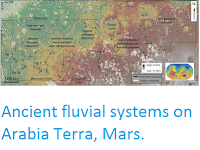
Lineament analysis of Google Earth imagery, Ennedi-Bourkou region, northern Chad, illustrating suite of curvilinear features interpreted as mega-scale glacial lineations traversing outcrop belts mapped as Devonian and Carboniferous. Sinuous belts of mega-scale glacial lineations are interpreted as paleo–ice stream pathways; neighbouring regions devoid of these are interpreted as inter-stream areas. The “Mousso” structure is a possible impact crater. Le Heron (2017).

Le Heron was able to detect five main sinuous belts, each 5-12 km in width, which, combined with the interstream areas, cover an area of about 6000 km². These belts can be traced for tens of kilometres, and run approximately north to south.


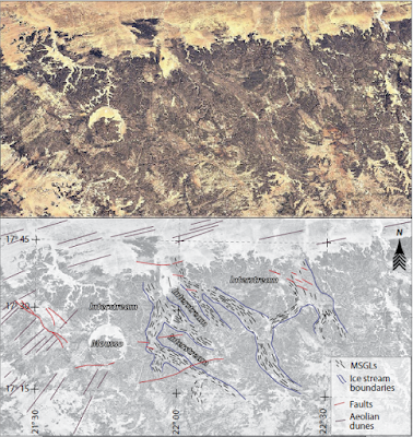
High-resolution view and interpretation of a paleo–ice stream track shown in Figure 2. Note deflection of mega-scale glacial lineations (MSGLs) around hill interpreted as a nunatak. Elevation of nunatak (1100 m) and of paleo–ice stream track to the west (850 m) allows maximum thickness of ice to be estimated (i.e. less than 250 m). La Heron (2017).<250 br="" m="">

The belts are cross-cut by more recent features, such as wadis and faults, supporting the interpretation of them as ancient structures, though it is impossible to tell whether they represent a single extended glacial event or a series of glacial cycles.

Series of snapshots from Google Earth imagery of the Ennedi-Bourkou plateaux (Chad) with accompanying interpretations. (A) Interaction of mega-scale glacial lineations (yellow lines) with dipping strata of presumed pre-glacial origin (orange lines), with interpreted glacial erosion surface indicated. Scale bar applies to immediate foreground only. (B) Low-angle perspective of interpreted palaeo–ice stream pathway shown in (A). Note interpreted inter-stream area which is devoid of mega-scale glacial lineations. (C) Mega-scale glacial lineations with evidence of fault offsets (faults in red), underscoring their antiquity (d—drumlins). (D) Development of mega-scale glacial lineations on two plateau levels. La Heron (2017).

The Chadian linear structures appear to cross cut layers of rock similar to those cross-cut by similar structures in Niger, which have been used to date the Niger structures to the Visean Stage, roughly 346.7 to 330.9 million years ago. This suggests an extensive Carboniferous ice sheet in the Sahara, draining to the north. This appears to correlate with an ancient palaeo-shoreline recorded in parts of northern Chad, and dated to about 350 million years ago. The absence of any known fluvial (river-generated) systems associated with this coastline suggests a significant ice-sheet covering the land and calving at the shore margin. 

Tentative paleogeographic reconstruction of Visean ice sheet in north-central Africa, incorporating ice flow directions in Aïr Massif of northern Niger with newly documented set of paleo–ice stream pathways in northern Chad. Speculated paleo–ice stream tracks are also shown. Coastline position for Tournasian at 350 Ma. Note close association of paleo–ice stream termini and palaeo-shoreline. La Heron (2017).

See also...

http://sciencythoughts.blogspot.co.uk/2017/10/greenhouse-warming-on-early-wet-mars.htmlhttp://sciencythoughts.blogspot.co.uk/2016/12/ontogeny-in-siphonodellid-conodonts.html
http://sciencythoughts.blogspot.co.uk/2016/10/ancient-fluvial-systems-on-arabia-terra.htmlhttp://sciencythoughts.blogspot.co.uk/2016/10/selenium-arsenic-and-molybdenum-in.html
http://sciencythoughts.blogspot.co.uk/2016/10/antennipatus-montceauensis-velvet-worm.htmlhttp://sciencythoughts.blogspot.co.uk/2016/08/saccoglossus-testa-new-species-of-acorn.html
Follow Sciency Thoughts on Facebook.

Thursday, 28 March 2013

Major landslip on Whidbey Island, Washington State.

A major landslip occurred on Whidbey Island, Washington State, at about 4.15 am local time (about 11.15 am GMT) on Wednesday 27 March 2013. Severely damaging one home and destroying a section of road that cut of twenty more. The twenty isolated homes and a further seventeen judged to be potentially unsafe by Central Whidbey Island Fire and Rescue were evacuated. No injuries have been reported, and only twelve people were reported to have been evacuated during the incident, as many properties in the area are holiday homes only inhabited seasonally.

House damaged by the 27 March landslip on Whidbey Island. Though apparently structurally sound this property has more-or-less totally lost its foundations, making it unlikely it can be saved. KING 5/Reuters.

Whidbey Island is notoriously prone to such erosional landslip events. Much of the island is made up of unconsolidated glacial deposits, held together with dried clay rather than lithified by mineral deposits. Such deposits can quickly become waterlogged following heavy rainfall (something Washington State is famed for) and lose all cohesion. The United States Geological Survey estimates that 51% of the coastline of Whidbey Island is at risk from such collapses.

Aerial photograph of part of the landslip on Whidbey Island. Associated Press.


Follow Sciency Thoughts on Facebook.