Showing posts with label Glaciation. Show all posts

Monday, 5 August 2019

Greenland loses 12.5 billion tons of ice in a single day.

The Greenland Ice Sheet is calculated to have lost a total of 12.5 billion tons of water on Wednesday 31 July 2019, the highest ice loss ever recorded in Greenland in a single day; the last time a comparable loss was recorded was in 2012, when 10 billion tons was lost in a single day, something which was at the time thought to be a once in 250 year event at the time, and comes as part of a total calculated loss of about 197 billion tons of ice in the whole of July, roughly enough to raise global sea levels by about 0.5 mm.

A lake on top of floating ice in the Ilulissat Icefjord on 30 July 2019. Sean Gallup/Getty Images.

The Greenland Ice Sheet contains a total of about 2 850 000 cubic kilometres (about 2 850 000 gigatonnes) of ice, enough to raise global sealevels by about 7.2 m should it all melt. Sea level rise is only caused by the melting of ice on land, since sea-ice is already displacing water, nevertheless, should all the ice currently locked up in glaciers on land (most of which is in Antarctica) melt, then the sealevel would rise by about 70 m, which would have a severe impact on Human civilisation. 

Sea also...

https://sciencythoughts.blogspot.com/2019/03/possible-second-large-impact-crater.htmlhttps://sciencythoughts.blogspot.com/2019/03/discovery-of-large-impact-crater.html
https://sciencythoughts.blogspot.com/2018/11/glacial-flour-creates-dust-storm-in.htmlhttps://sciencythoughts.blogspot.com/2015/05/groundwater-systems-beneath-mcmurdo-dry.html
https://sciencythoughts.blogspot.com/2014/01/the-end-of-little-ice-age.htmlhttps://sciencythoughts.blogspot.com/2013/11/massive-iceberg-breaks-away-from-pine.html
Follow Sciency Thoughts on Facebook.

Saturday, 30 December 2017

Evidence for a Carboniferous glaciation in the Ennedi-Bourkou Mountains of northern Chad.

During the Late Palaeozoic the supercontinent of Gondwana covered the Southern Polar Region, with the Pole itself moving across Africa and Australia. Evidence for an extensive Southern Polar Glaciation has been found in South Australia, Oman, Ethiopia, Brazil, Egypt, Niger, and Libya. The glaciation seen in Niger and Libya seems extremely likely to continue across the northern part of Chad, which separates the the two regions, however, the remote nature and political instability of this region has prevented exploration by geologists to date.

In a paper published in the journal Geology on 29 November 2017, Daniel Le Heron of the Department of Earth Sciences at Royal Holloway, University of London, describes the results of a study of the topography of the Ennedi-Bourkou Mountains of northern Chad, made using satellite data from Google Earth, which shows the presence of an extensive Carboniferous ice-stream system.

The Ennedi-Bourkou Mountains form the southern margin of the Al Kufrah Basin, which has striated surfaces interpreted as glacial in origin around Jabal Azbah on its eastern margin, in southern Libya. However no such structures have previously been described from the less well explored Chaddian portion of the basin. Le Heron found that the Ennedi-Bourkou Mountains show a series of sinuous belts cutting across a sandstone platform dated to the Carboniferous in the early 1960s (when nobody was looking for evidence of glaciation in the Central Sahara).
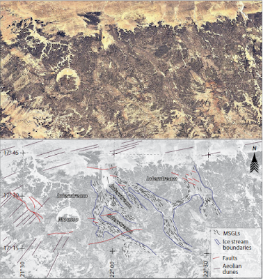
Lineament analysis of Google Earth imagery, Ennedi-Bourkou region, northern Chad, illustrating suite of curvilinear features interpreted as mega-scale glacial lineations traversing outcrop belts mapped as Devonian and Carboniferous. Sinuous belts of mega-scale glacial lineations are interpreted as paleo–ice stream pathways; neighbouring regions devoid of these are interpreted as inter-stream areas. The “Mousso” structure is a possible impact crater. Le Heron (2017).

Le Heron was able to detect five main sinuous belts, each 5-12 km in width, which, combined with the interstream areas, cover an area of about 6000 km². These belts can be traced for tens of kilometres, and run approximately north to south.


High-resolution view and interpretation of a paleo–ice stream track shown in Figure 2. Note deflection of mega-scale glacial lineations (MSGLs) around hill interpreted as a nunatak. Elevation of nunatak (1100 m) and of paleo–ice stream track to the west (850 m) allows maximum thickness of ice to be estimated (i.e. less than 250 m). La Heron (2017).<250 br="" m="">

The belts are cross-cut by more recent features, such as wadis and faults, supporting the interpretation of them as ancient structures, though it is impossible to tell whether they represent a single extended glacial event or a series of glacial cycles.

Series of snapshots from Google Earth imagery of the Ennedi-Bourkou plateaux (Chad) with accompanying interpretations. (A) Interaction of mega-scale glacial lineations (yellow lines) with dipping strata of presumed pre-glacial origin (orange lines), with interpreted glacial erosion surface indicated. Scale bar applies to immediate foreground only. (B) Low-angle perspective of interpreted palaeo–ice stream pathway shown in (A). Note interpreted inter-stream area which is devoid of mega-scale glacial lineations. (C) Mega-scale glacial lineations with evidence of fault offsets (faults in red), underscoring their antiquity (d—drumlins). (D) Development of mega-scale glacial lineations on two plateau levels. La Heron (2017).

The Chadian linear structures appear to cross cut layers of rock similar to those cross-cut by similar structures in Niger, which have been used to date the Niger structures to the Visean Stage, roughly 346.7 to 330.9 million years ago. This suggests an extensive Carboniferous ice sheet in the Sahara, draining to the north. This appears to correlate with an ancient palaeo-shoreline recorded in parts of northern Chad, and dated to about 350 million years ago. The absence of any known fluvial (river-generated) systems associated with this coastline suggests a significant ice-sheet covering the land and calving at the shore margin. 

Tentative paleogeographic reconstruction of Visean ice sheet in north-central Africa, incorporating ice flow directions in Aïr Massif of northern Niger with newly documented set of paleo–ice stream pathways in northern Chad. Speculated paleo–ice stream tracks are also shown. Coastline position for Tournasian at 350 Ma. Note close association of paleo–ice stream termini and palaeo-shoreline. La Heron (2017).

See also...

http://sciencythoughts.blogspot.co.uk/2017/10/greenhouse-warming-on-early-wet-mars.htmlhttp://sciencythoughts.blogspot.co.uk/2016/12/ontogeny-in-siphonodellid-conodonts.html
http://sciencythoughts.blogspot.co.uk/2016/10/ancient-fluvial-systems-on-arabia-terra.htmlhttp://sciencythoughts.blogspot.co.uk/2016/10/selenium-arsenic-and-molybdenum-in.html
http://sciencythoughts.blogspot.co.uk/2016/10/antennipatus-montceauensis-velvet-worm.htmlhttp://sciencythoughts.blogspot.co.uk/2016/08/saccoglossus-testa-new-species-of-acorn.html
Follow Sciency Thoughts on Facebook.

Thursday, 11 August 2016

Bubble-like caves in the Laoshan Granite of Shandong Province.

Large bodies of ice are known to have covered wide ares of Europe and North America during the Pleistocene galciations, however evidence for similar glaciation in China has been harder to find, which is puzzling as it is difficult to explain how China wouldhave excaped such a glaciation. One piece of evidence that has been used to support the idea of glaciation in northern China is the presence of a number of small cave systems in the Laoshan Granite, which outcrops around Qingdao in Shandong Province in northeast China. Granite is a volcaninc rock formed by the slow cooling of magmatic material deep beneath the ground, which enables large, visible, mineral grains to form. These larger grains are more prone to weathering by freeze-thaw conditions than the smaller mineral grains that make up extruded lavas and basalts, thus enhanced erosion of granites can be evidence of freezing conditions in the past.

In a paper published in the journal Acta Geologica Sinica in February 2016, Song Zaojun of the Shandong Provincial Key Laboratory of Depositional Mineralization & Sedimentary Minerals at the Shandong University of Science and Technology, Lui Xiqing of the Qindao Institute of Marine Geology, Tang Wenjia, Gao Luo and Li Jianping, also of the Shandong Provincial Key Laboratory of Depositional Mineralization & Sedimentary Minerals at the Shandong University of Science and Technology, and Luan Shaogang, of the Qingdao Laoshan Scenic Area Adminstrative Bureau, re-examine the caves of the Laoshan Granite, and propose an alternative hypothesis for their formation.

Song et al. note that the Laoshan Granite contains a number of small caves, with bubble-like shapes, averaging 1-2 m across, with the largest measuring 3.1 m in diameter. However they also note that the Laoshan Granite is mariolitic in nature; that is to say it contains, as well as the larger caves, smaller bubble-structures (vesicles) believed to have formed by pockets of gas evolved by the cooling magmatic rock which were unable to excape the burried granite. Such vesicles are common in granites, often cotaining larger crystals formed later from minerals disolved in water that percolated through the rocks (geodes). 

Bubble cave north of Laoshan Reservoir. Song et al. (2016).

Mairiolitic caves as large as the Laoshan Granite structures have never previously been recorded. Nevertheless Song et al. conclude that, based upon the morphology of the caves, a mariolitic origin is more likely that a glacial erosion based one.

Large cave near Tiaqinggong. Song et al. (2016).

See also...

http://sciencythoughts.blogspot.co.uk/2016/07/understanding-how-caldera-collapse.htmlUnderstanding how caldera-collapse drove the 2014-15 Bárdarbunga eruption in Iceland.                                                    Between August 2014 and February 2015 the Bárdarbunga...
http://sciencythoughts.blogspot.co.uk/2015/02/the-dangers-of-naturally-occurring.htmlThe dangers of naturally occurring asbestos in southern Nevada.                                               Asbestos refers to a number of forms of naturally occurring fibrous amphibole minerals known to be highly carcinogenic, and also linked to a number of other health problems, including cardiovascular...
http://sciencythoughts.blogspot.co.uk/2014/12/understanding-tokapal-kimberlite.htmlUnderstanding the Tokapal Kimberlite. Kimberlites are uncommon geological formations formed by the extrusion of mantle material from deep within the Earth. Despite the relatively small number of kimberlites known, they have been the subject...
Follow Sciency Thoughts on Facebook. 

Sunday, 13 December 2015

Evidence of an Ice Age at the start of the Middle Jurassic.

The Jurassic lasted approximately 65.3 million years, from about 201.3 million years ago till about 145 million years ago, and is generally considered to have been a period of exceptional greenhouse warming. It is divided into the Early, Middle and Late Jurassic, each with its own distinctive climates and faunas (as well as shorter subdivisions). The Early Jurassic ended 174.1 million years ago with the Toarcian Extinction Event, a period of exceptional warming triggered by volcanic activity in South Africa that sharply increased the amount of carbon dioxide in the atmosphere, which in turn triggered an anoxic ocean event (warmer water is less able to hold dissolved oxygen), causing many groups of marine organisms to die out. Recent evidence has suggested that this may have been followed by a period of severe cooling at the beginning of the Middle Jurassic; this has included signs of ice rafted debris in Jurassic Arctic basins and the formation of the mineral glendonite, a form of calcite which only forms in cold water, though it has not been suggested that there was significant glaciation on land (neither pole was covered by a continental land-mass in the Jurassic).

In a paper published in the journal Nature Communications on 11 December 2015, Christoph Korte of the Department of Geosciences and Natural Resource Management at the University of Copenhagen, Stephen Hesselbo of the Camborne School of Mines and Environment and Sustainability Institute at the University of Exeter, Clemens Ullmann of the Department of Geosciences and Natural Resource Management at the University of Copenhagen and the Camborne School of Mines and Environment and Sustainability Institute at the University of Exeter, Gerd Dietl of the Staatliches Museum für Naturkunde Stuttgart, Micha Ruhl of the Department of Earth Sciences at the University of Oxford, Günter Schweigert, also of the Staatliches Museum für Naturkunde Stuttgart and Nicolas Thibault, again of the Department of Geosciences and Natural Resource Management at the University of Copenhagen examine evidence for a cooling event at the start of the Middle Jurassic from oxygen isotope levels from Belemnite, Bivalves and Brachiopod shells from the Laurasian Seaway.

Oxygen has three stable isotopes, Oxygen-16, Oxygen-17 and Oxygen-18, with the heaviest, Oxygen-18 being the most abundant. As Oxygen-18 is slightly heavier at than the other isotopes water molecules containing this isotope require slightly more energy  to evaporate at the water surface, so under cooler conditions the proportion of Oxygen-18 in the water rises and under warmer conditions it falls. Many marine organisms with calcite shells store oxygen in their shells in a proportion that matches the surrounding water, enabling palaeontologists and geochemists to use this proportionality as a reliable proxy for the temperature in ancient marine deposits.

During the Jurassic the continents were joined together into a single supercontinent, Pangea. This was roughly 'C' shaped, with the interior part of the 'C' forming an equatorial ocean, the Tethys. However the Jurassic had a very warm climate, with subsequent high sea levels, and many areas of the continents were flooded. In particular an epicontinental sea (sea which lies on submerged continental crust), the Laurasian Seaway covered much of what is now Europe, connecting the tropical Tethys Ocean to the Boreal Sea around the North Pole, and allowing water to circulate between the two (in the modern world the Bering Straight is another such epicontinrntal seaway, connecting the Pacific to the Arctic across an area that is part of the North American Continental Plate, an area which was exposed during the Pleistocene glaciations).

By examining shells from the early Middle Jurassic of the Laurasian Seaway that showed little sign of alteration (recrystalization of replacement of the original calcite crystals), Korte et al. were able to detect a rise in Oxygen-18 of 2.5 parts in a thousand, equivalent to a drop in temperature of 10 degrees centigrade, over a period of about half a million years.

During this period the area that is now the North Sea, and which was then part of the Laurasian Seaway, is known to have undergone considerable uplift, driven by a rising volcanic plume from deep within the Earth, similar to the Yellowstone Plume beneath modern Wyoming (such a plume would not need to erupt as the surface to cause significant uplift, emplacing new material on the underside of the overlying tectonic plate would have the same effect), while at the same time Ammonite distributions across the Laurasian Seaway became fragmented by latitude (i.e. instead of having the same group of species across the seaway as in the Early Jurassic, different populations began to appear in the north and south). Korte et al  suggest that the rising North Sea Dome may have blocked the Laurasian Seaway, preventing currents running between the Tethys Ocean and Boreal Sea, thereby causing cooling in the Boreal Sea and possibly the formation of pack ice.

Late Early Jurassic palaeogeography. (a) Map shows the connection between the equatorial Tethys Ocean and the Boreal Sea via the Laurasian Seaway; the latter including the Viking Corridor which was several hundred kilometres wide. Red arrows mark generalized palaeocurrents. (b) Detail of Laurasian Seaway palaeogeography with the region affected by North Sea Dome as determined by the generalized outer limit of the Toarcian subcrop. Brown arrows represent the siliciclastic sediment supply/transport in relation to domal uplift. Sample locations are numbered and identified by stars (Hebrides Basin (I; Scotland), Cleveland Basin (II; England), Swabo-Franconian Basin (III; Germany) and Lusitanian (IV; Portugal)/Basque Cantabrian basins (V; Spain)). SNS, Southern North Sea Basin, W, Wessex Basin. Korte et al. (2015).

See also...
http://sciencythoughts.blogspot.co.uk/2015/03/the-reaction-of-marine-invertebrates-to.htmlThe reaction of marine invertebrates to global warming during the Early Jurassic Toarcian Extinction Event.                                                   About 183 million years ago a major eruptive episode in the Karoo-Ferrar Large Igneous Province of South Africa lead to an abrupt rise in global atmospheric...
http://sciencythoughts.blogspot.co.uk/2013/11/a-late-jurassic-lagerstatte-from.htmlA Late Jurassic lagerstätte from central Poland                                                          The term lagerstätte is used by Palaeontologists to describe a particularly rich fossil source; a site where fossils are either exceptionally numerous...
http://sciencythoughts.blogspot.co.uk/2013/09/opportunistic-bivalves-during-early.htmlOpportunistic Bivalves during the Early Jurassic Toarcian Oceanic Anoxic Event. The Toarcian Oceanic Anoxic Event is an extinction event that took place in the Early Jurassic, about 183 million years ago. It took place in four phases, thought to have been related to Milankovitch Cycles. During each phase the temperature of the global ocean is thought...
 Follow Sciency Thoughts on Facebook.