Showing posts with label Kermadec Trench. Show all posts

Saturday, 24 September 2022

Warnings issued to mariners and aviators after Home Reef Volcano, Tonga, erupts eight times in forty eight hours.

Warnings have been issued to air and sea traffic after Home Reef Volcano, an ephemeral island volcano in Tonga, erupted eight times in a 48 hour period between 18 and 20 September 2022. Aviators have been warned not to approach within three kilometres of the volcano, due to the dangers of volcanic ash to aircraft engines, and mariners have been advised not to approach the volcano and to be vigilant for rafts of floating pumice (volcanic rock with numerous large pore-spaces which can float on water), which can be damaging to boats.

Image of an eruption on Home Reef captured by the Operational Land Imager-2 instrument on the Landsat-9 satellite on 14 September 2022. NASA/Earth Observatory.

Home Reef is usually beneath the water, but the formation of temporary islands from ash effusions which are subsequently washed away has previously recorded in 1852, 1857, 1984 and 2006. The volcano began to erupt again on 10 September 2022, and by 17 September had formed an island with an area of 24 300 m², which by 23 September had grown to 32 375 m².

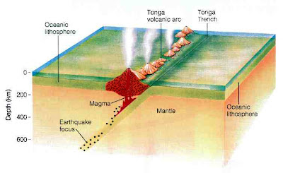
Home Reef lies on the Tonga/Kermadec Ridge, and is fed by the subduction of the Pacific Plate beneath the Australian Plate along the Kermadec/Tonga Trench. As the Pacific Plate sinks into the Earth, it is warmed by the heat from the planets interior. This leads to partial melting of the Pacific Plate, with some of the melted material rising through the overlying Australian Plate as magma, fuelling the volcanos of the Kermadec/Tonga Ridge.

Diagram showing subduction along the Tonga Trench, and how this feeds the volcanoes of the Tonga Volcanic Arc. York University.

See also... 


Follow Sciency Thoughts on Facebook.

Follow Sciency Thoughts on Twitter.


Saturday, 15 January 2022

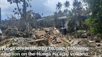
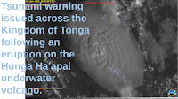
Tsunami warning issued across the Kingdom of Tonga following an eruption on the Hunga Ha'apai underwater volcano.

A tsunami warning was issued to people living in coastal areas on all the islands of the Kingdom of Tonga on Thursday 13 January 2022, following an eruption on the Hunga Ha'apai underwater volcano, which produced a column of gas and ash about 20 km high. In the event, the largest wave observed was only about 30 cm high, which reached Nuku'alofa on the north coast of the island of Tongatapu at about 12.30 pm local time. The volcano began its current eruptive cycle on 20 December 2021, prior to which it had been inactive since 2015.

 
GOES-17 satellite imigary of the 13 January 2022 Hunga Ha'apai underwater volcano eruption. University of Wisconsin Madison/Space Science and Engineering Center/CIMMS Satelite Blog.

Hunga Ha’apai lies on the Tonga/Kermadec Ridge, and is fed by the subduction of the Pacific Plate beneath the Australian Plate along the Kermadec/Tonga Trench. As the Pacific Plate sinks into the Earth, it is warmed by the heat from the planets interior. This leads to partial melting of the Pacific Plate, with some of the melted material rising through the overlying Australian Plate as magma, fuelling the volcanos of the Kermadec/Tonga Ridge.

 
Diagram showing subduction along the Tonga Trench, and how this feeds the volcanoes of the Tonga Volcanic Arc. York University.

See also...


Follow Sciency Thoughts on Facebook.

Follow Sciency Thoughts on Twitter.


Wednesday, 22 December 2021

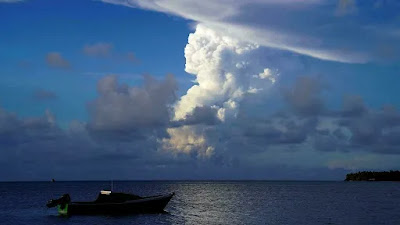
Eruption on Hunga Ha'apai volcano, Tongo.

The remote Hunga Ha'apai volcano in Tongo erupted on Monday 20 December 2021, producing an ash column 18 km high, and ash-falls across the island group. There are no reports of any casualties associated with this event, however, local authorities are warning people not to collect rainwater for drinking (a common practice in a nation where many communities do not have access to other water sources) until the ash cloud has cleared, due to the dangers of acid rain, which can cause severe health problems. Aircraft were warned to keep away from the islands during the eruption, resulting in the cancellation of at least one flight.

 
An eruption on the Hunga Ha'apai volcano, seen from Nuku'alofa on Monday 20 December 2021. Mary Lyn Fonua/AFP.

Hunga Ha’apai lies on the Tonga/Kermadec Ridge, and is fed by the subduction of the Pacific Plate beneath the Australian Plate along the Kermadec/Tonga Trench. As the Pacific Plate sinks into the Earth, it is warmed by the heat from the planets interior. This leads to partial melting of the Pacific Plate, with some of the melted material rising through the overlying Australian Plate as magma, fuelling the volcanos of the Kermadec/Tonga Ridge.
 
 
Diagram showing subduction along the Tonga Trench, and how this feeds the volcanoes of the Tonga Volcanic Arc. York University.
 
See also...


Follow Sciency Thoughts on Facebook.

Follow Sciency Thoughts on Twitter.


Monday, 27 February 2017

Persistent organic pollutants in animals in the deepest ocean trenches.

The presence of man-made chemicals is known to be a problem in a wide variety of environments, not just locations where Humans are present, but in remote areas such as the Arctic and High Himalayas. Such pollution in the world’s oceans is of particular concern, with visible concentrations of plastics on the ocean gyres and remote areas of the seafloor, and man-made chemicals, many with known ill-effect, recorded in a wide variety of marine organisms, including many species that form part of our own diet. The only areas where such pollutants have not been found are the deep ocean trenches that form in the subduction zones where one tectonic plate is pushed under another, though this is not evidence of actual absence, as these areas have not to date been sampled for such chemicals.

In a paper published in the journal Nature Ecology & Evolution on 13 February 2017, Alan Jamieson of the Oceanlab of the Institute of Biological and Environmental Sciences at the University of Aberdeen and the School of Marine Science and Technology at Newcastle University, Tamas Malkocs and Stuart Piertney of the Institute of Biological and Environmental Sciences at the University of Aberdeen, Toyonobu Fujii, also of the Oceanlab of the Institute of Biological and Environmental Sciences at the University of Aberdeen, and Zulin Zhang of Environmental and Biochemical Sciences at The James Hutton Institute, describe the results of a study that looked for two persistent organic pollutants in benthic Amphipod Crustaceans collected from the Mariana and Kermadec Trenches in the Pacific.

The Mariana Trench in the North Pacific is considered to be the deepest point in all the world’s oceans, and is a highly oligotrophic (low nutrient) environment, while the Kermadec Trench of the South Pacific is only slightly shallower and is more eutrophic (i.e. more nutrients are available). Amphipods were collected from both trenches using traps deployed by deep sea landers. Two species of Amphipods, Hirondellea dubia and Bathycallisoma schellenbergi, were collected from the Kermadec Trench at depths of between 7227 and 10 000 m, while a single species, Hirondellea gigas, was collected from the Mariana Trench at depths of between 7841 and 10 250 m.

 
Specimens of Hirondellea gigas, an Amphipod Crustacean from the Mariana Trench. Alan Jamieson.

These were tested for two persistent organic pollutants known to bioaccumulate in food chains, being absorbed by organisms close to the bottom and becoming more concentrated with each step up the chain. These were polychlorinated biphenyls (PCBs), which were used in the manufacture of electronic goods between the 1930s and 1970s, and polybrominated diphenyl ethers (PBDEs), which are used as flame retardants. Both are extremely hard to break down in natural environments, and have previously been recorded from coastal sediments, open ocean waters and the polar regions.

Both PCBs and PBDEs were present in the majority of samples from both locations. PCBs were found in Amphipods from the Mariana Trench at concentrations of 147.3-905 nanograms per gram, and in the Kermadec Trench at concentrations of 18.03-42.85 in the Kermadec, while PBDEs were present at concentrations of 5.82-28.93 in the Mariana Trench and 13.75-31.02 in the Kermadec Trench. There was no clear correlation between depth and pollutant concentration, though in both locations the highest chemical concentrations were found in Amphipods captured near the shallower end of the range, at 7841 m in the Mariana Trench and 7227 in the Kermadec Trench.

The PCB levels in the Mariana Trench were notably higher than those in the Kermadec, and indeed in comparison to samples from shallow and surface environments. Crabs from paddy fields on the Liaohe River, considered to be one of the most polluted in China, only have PCB levels about one fiftieth that seen in the Mariana Trench, while highly polluted coastal sediments from Guam, Japan and Australia had levels of 314, 240 and 160 nanograms per gram respectively.

This high concentration is remarkable, and requires explanation. Jamieson et al. consider a number of possibilities. Firstly the Mariana Trench is close to the highly polluted North Pacific Subtropical Gyre (also known as the ‘Great Pacific Garbage Patch’) a massive patch of plastic debris which partially overlies the trench. This can potentially lead to degraded plastic debris and plastic derived chemicals sinking directly into the Trench. Secondly the chemicals may be derived from carrion falls into the trench (a major source of food for benthic Amphipods) which have high levels of plastic-derived chemicals. However the consistently high PCB levels across the nutrient poor Mariana Trench make this seem unlikely. Thirdly it is possible that the species present in the Mariana Trench (Hirondellea gigas) is particularly prone to bioaccumulating PCBs due to some aspect of their physiology, though this would be surprising given the ecological similarity of the Mariana Amphipods to the Kermadec species, this also seems unlikely.

Instead Jamieson et al. suggest that high levels of PCBs may be accumulating in the Mariana Trench due to the topology of the Trench itself. The Trench is generally seen as an exceptionally deep structure, with the bottom remote from surface waters, and often depicted with a comparison to Mount Everest (which would not reach the sea surface if it sat in the Mariana Trench). However it is not as deep as part of the Mississippi River is wide, nor Manhattan Island is long, so the waters at the bottom of the Trench cannot be seen as truly separate from those at the surface. Studies made in the Japan Trench following the 2011 Fukushima Dia-ichi nuclear disaster suggested that particulate matter in the ocean sank at rates of 64–78 m per day, which would enable material derived from the North Pacific Subtropical Gyre to reach the deepest parts of the Mariana Trench in under 170 days. Such material settling on the seafloor of the ocean plains would be subject to further movement by deep ocean currents, eventually spreading more-or-less evenly across these vast areas, but chemicals sinking into the Mariana Trench would become concentrated, as the depth of the trench protects its contents from the ocean currents.

See also...

http://sciencythoughts.blogspot.co.uk/2016/12/epimeria-abyssalis-new-species-of.htmlhttp://sciencythoughts.blogspot.co.uk/2015/10/microplastics-in-deep-sea-marine.html
http://sciencythoughts.blogspot.co.uk/2015/03/methyl-mercury-levels-in-feathers-of.htmlhttp://sciencythoughts.blogspot.co.uk/2014/12/counting-floating-plastics-in-worlds.html
http://sciencythoughts.blogspot.co.uk/2014/05/marine-litter-on-european-seafloor.htmlhttp://sciencythoughts.blogspot.co.uk/2013/11/the-ten-most-polluted-places-on-earth.html
Follow Sciency Thoughts on Facebook.