Showing posts with label Tonga Trench. Show all posts

Saturday, 24 September 2022

Warnings issued to mariners and aviators after Home Reef Volcano, Tonga, erupts eight times in forty eight hours.

Warnings have been issued to air and sea traffic after Home Reef Volcano, an ephemeral island volcano in Tonga, erupted eight times in a 48 hour period between 18 and 20 September 2022. Aviators have been warned not to approach within three kilometres of the volcano, due to the dangers of volcanic ash to aircraft engines, and mariners have been advised not to approach the volcano and to be vigilant for rafts of floating pumice (volcanic rock with numerous large pore-spaces which can float on water), which can be damaging to boats.

Image of an eruption on Home Reef captured by the Operational Land Imager-2 instrument on the Landsat-9 satellite on 14 September 2022. NASA/Earth Observatory.

Home Reef is usually beneath the water, but the formation of temporary islands from ash effusions which are subsequently washed away has previously recorded in 1852, 1857, 1984 and 2006. The volcano began to erupt again on 10 September 2022, and by 17 September had formed an island with an area of 24 300 m², which by 23 September had grown to 32 375 m².

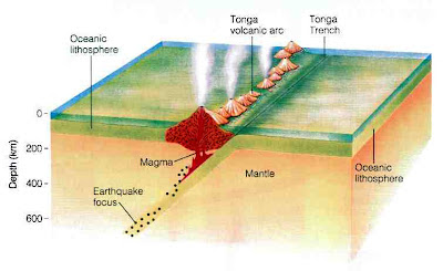
Home Reef lies on the Tonga/Kermadec Ridge, and is fed by the subduction of the Pacific Plate beneath the Australian Plate along the Kermadec/Tonga Trench. As the Pacific Plate sinks into the Earth, it is warmed by the heat from the planets interior. This leads to partial melting of the Pacific Plate, with some of the melted material rising through the overlying Australian Plate as magma, fuelling the volcanos of the Kermadec/Tonga Ridge.

Diagram showing subduction along the Tonga Trench, and how this feeds the volcanoes of the Tonga Volcanic Arc. York University.

See also... 


Follow Sciency Thoughts on Facebook.

Follow Sciency Thoughts on Twitter.


Thursday, 20 January 2022

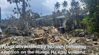
Tonga devastated by tsunami following eruption on the Hunga Ha'apai volcano

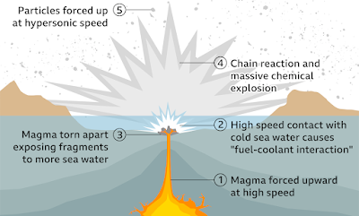
Three people, including a British citizen, have been confirmed dead and many more are missing following a tsunani that swept across the island nation of Tonga on Saturday 15 January 2022, following an eruption on the Hunga Ha'apai volcano. The volcano, which is usually underwater and is about 65 km to the north of the nation's capital, Nukuʻalofa, began erupting on 20 December 2021, producing a small island by the first week of January. However, on 15 January the centre of this island sank abruptly beneath the sea about two hours before the eruption. Vulcanologists have hypothesised that the eruption was caused by the collapse of a magma chamber, allowing seawater to come into contact with the hot magma, and triggering a phreatic explosion (rapid expansion of gas as a large volume of water turns to vapour more-or-less instantly).

 
Devastation on Tonga caused by the 15 January 2022 tsunami. Consulate of the Kingdom of Tonga.

Following the explosion a huge wave swept across the islands of Tonga, then out across the Pacific Ocean, reaching Australia and New Zealand in four hours, Japan in eight hours, California in ten hours and Alaska in eleven. Ths islands of Tonga suffered extensive damage, which destroyed much of the nation's communications infrastructure, with the extent of the destruction only becoming clear as ships from the New Zealand Navy reached the area several days later. As well as the obvious problems caused by the devastation of the nation's infrastructure, much of the area has been covered by sulphur-rich volcanic dust, which can be harmful if breathed in, and can react with fresh water to form sulphuric acid, threatening drinking water supplies. 

 
How a submarine phraetic explosion can cause a tsunami. BBC.

Hunga Ha’apai lies on the Tonga/Kermadec Ridge, and is fed by the subduction of the Pacific Plate beneath the Australian Plate along the Kermadec/Tonga Trench. As the Pacific Plate sinks into the Earth, it is warmed by the heat from the planets interior. This leads to partial melting of the Pacific Plate, with some of the melted material rising through the overlying Australian Plate as magma, fuelling the volcanos of the Kermadec/Tonga Ridge.

 
Diagram showing subduction along the Tonga Trench, and how this feeds the volcanoes of the Tonga Volcanic Arc. York University.

See also...


Follow Sciency Thoughts on Facebook.

Follow Sciency Thoughts on Twitter.


Saturday, 15 January 2022

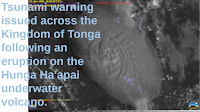
Tsunami warning issued across the Kingdom of Tonga following an eruption on the Hunga Ha'apai underwater volcano.

A tsunami warning was issued to people living in coastal areas on all the islands of the Kingdom of Tonga on Thursday 13 January 2022, following an eruption on the Hunga Ha'apai underwater volcano, which produced a column of gas and ash about 20 km high. In the event, the largest wave observed was only about 30 cm high, which reached Nuku'alofa on the north coast of the island of Tongatapu at about 12.30 pm local time. The volcano began its current eruptive cycle on 20 December 2021, prior to which it had been inactive since 2015.

 
GOES-17 satellite imigary of the 13 January 2022 Hunga Ha'apai underwater volcano eruption. University of Wisconsin Madison/Space Science and Engineering Center/CIMMS Satelite Blog.

Hunga Ha’apai lies on the Tonga/Kermadec Ridge, and is fed by the subduction of the Pacific Plate beneath the Australian Plate along the Kermadec/Tonga Trench. As the Pacific Plate sinks into the Earth, it is warmed by the heat from the planets interior. This leads to partial melting of the Pacific Plate, with some of the melted material rising through the overlying Australian Plate as magma, fuelling the volcanos of the Kermadec/Tonga Ridge.

 
Diagram showing subduction along the Tonga Trench, and how this feeds the volcanoes of the Tonga Volcanic Arc. York University.

See also...


Follow Sciency Thoughts on Facebook.

Follow Sciency Thoughts on Twitter.


Wednesday, 22 December 2021

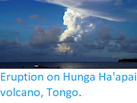
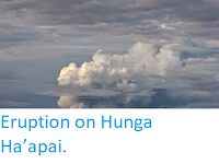
Eruption on Hunga Ha'apai volcano, Tongo.

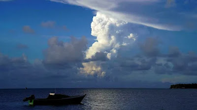
The remote Hunga Ha'apai volcano in Tongo erupted on Monday 20 December 2021, producing an ash column 18 km high, and ash-falls across the island group. There are no reports of any casualties associated with this event, however, local authorities are warning people not to collect rainwater for drinking (a common practice in a nation where many communities do not have access to other water sources) until the ash cloud has cleared, due to the dangers of acid rain, which can cause severe health problems. Aircraft were warned to keep away from the islands during the eruption, resulting in the cancellation of at least one flight.

 
An eruption on the Hunga Ha'apai volcano, seen from Nuku'alofa on Monday 20 December 2021. Mary Lyn Fonua/AFP.

Hunga Ha’apai lies on the Tonga/Kermadec Ridge, and is fed by the subduction of the Pacific Plate beneath the Australian Plate along the Kermadec/Tonga Trench. As the Pacific Plate sinks into the Earth, it is warmed by the heat from the planets interior. This leads to partial melting of the Pacific Plate, with some of the melted material rising through the overlying Australian Plate as magma, fuelling the volcanos of the Kermadec/Tonga Ridge.
 
 
Diagram showing subduction along the Tonga Trench, and how this feeds the volcanoes of the Tonga Volcanic Arc. York University.
 
See also...


Follow Sciency Thoughts on Facebook.

Follow Sciency Thoughts on Twitter.


Friday, 5 March 2021

Magnitude 8.1 Earthquake in the Kermadec Islands.

The United States Geological Survey recorded a Magnitude 8.1 Earthquake at a depth of 19.4 km, in the Kermadec Islands, to the north of New Zealand, slightly before 6.30 am local time on Fridat 5 March 2021 (slighty before 7.30 pm on Thursday 4 March, GMT). The event was felt in the islands, and triggered a tsunami warning in New Zealand, where many people were evacuated from low lying areas on North Island, although in the the event, while some notable waves were observed, no damage or flooding was recorded.

The approximate location of the 5 March 2021 Kermadec Earthquake. USGS.

The event was part of a swarm of Earthquakes that has hit the area over the past 24 hours, with two focus points observed, one in the Kermadec Islands and one off the northeast coast of North Island. Two other Earthquakes with Magnitudes in excess of 7.0 have been recorded during this series of events, one in the Kermadec Islands, and one off the coast of North Island.

 
Earthquakes around New Zealand and the Kermadec Islands on 4-5 March 2021. The event indicated in red is the most recent. USGS.

The Kermadec Islands lie along the boundary between the Pacific and Australian Tectonic Plates. The Pacific Plate is being subducted beneath the Australian Plate along the Tonga Trench, which forms the boundary between these two plates, with the volcanic islands that make up the archipelago being formed as the subducting plate is melted by the heat of the planet's interior, so that lighter minerals rise up through the overlying plate as liquid magma, which fuels the volcanoes that build the islands. This subduction is not a smooth process, with the two plates constantly sticking together until the pressure generated by their movement builds up sufficiently to break them apart, causing a sudden forward jerk we experience as an Earthquake.
 
 
Diagram showing subduction along the Tonga Trench, and how this feeds the volcanoes of the Tonga Volcanic Arc. York University.
 
Further south, New Zealand is also located on the boundary beneath the Australian and Pacific Plates. Beneath the islands the Pacific Plate is being subducted beneath the Australian Plate. This causes a great deal of friction which causes Earthquakes where the boundary between the two plates is close to the surface; this is to the east of North Island, but onshore on South Island, where it can lead to strong Earthquakes. Technically such quakes also occur where the plate margin is deeper, but these are felt less strongly as the rocks between the boundary and the surface absorb much of the energy, making strong tremors much less frequent on North Island. As the Pacific Plate sinks deeper into the Earth it is partially melted by the friction and the heat of the planet's interior. Some of the melted material then rises through the overlying Australian Plate, fuelling the volcanoes of New Zealand.
 
The subduction zone beneath New Zealand, and how if fuels Earthquakes and volcanoes. Te Ara.
 
Earthquakes along subductive margins are particularly prone to causing tsunamis, since these often occur when the overlying plate has stuck to the underlying plate, being pulled out of shape by its movement.. Eventually the pressure builds up to far and the overlying plate snaps back, causing an Earthquake and a tsunami. 
 
 
Simplified graphic showing tsunami generation along a convergent margin.NASA/JPL/CalTech.
 
Witness reports of Earthquakes can help scientists to understand these events, and the underlying geologic processes that cause them. If you have felt an Earthquake in New Zealand then you can report it to the GeoNet project, which monitors quakes in New Zealand, here. 
 
See also...


Follow Sciency Thoughts on Facebook.

Follow Sciency Thoughts on Twitter.


Wednesday, 16 September 2020

Magnitude 6.0 Earthquake to the north of Vanua Levu Island, Fiji.

The United States Geological Survey recorded a Magnitude 6.0 Earthquake at a depth of about 10 km, roughly 160 km to the north of Vanua Levu Island, Fiji, slightly after 4.10 pm local time (slighly after 4.10 am GMT) on Tuesday 15 September 2020. There are no reports of any damage or injuries relating to this quake, but it was felt on Vanua Levu.


The approximate location of the 15 September 2020 Fiji Earthquake. USGS.

The tectonic setting of Fiji is somewhat complicated. The islands form part of the border zone between the Pacific and Australian Plates, with the boundary passing to the north as a transform plate margin, along which the Pacific Plate is moving westwards, relative to Fiji. However, Fiji itself lies on an area of newly forming plate, with an are of expansion to its west, the Fiji Basin, which is pushing Fiji to the east relative to the Pacific Plate. Further to the west the Indo-Australian Plate is being subducted beneath this new microplate along the New Hebrides Trench. To the east of Fiji, a second area of seafloor spreading occurs along the Lau-Colville Ridge, and to the east of that the Pacific Plate is also being subducted, along the Tonga Trench. This means that the islands of Fiji are being subjected to tectonic stresses from several different directions. These stresses do not manifest themselves as smooth movements, but rather sharp jolts which we experience as Earthquakes, as the rocks of the various plates tend to adhere together, only breaking apart once the built-up pressures become to great, and settling into new positions.

 
Map and cross section showing the positions and movements of the tectonic plates around Fiji. Mörner & Matlack-Klein (2017).
 
Witness accounts of Earthquakes can help geologists to understand these events, and the structures that cause them. The international non-profit organisation Earthquake Report is interested in hearing from people who may have felt this event; if you felt this quake then you can report it to Earthquake Report here.

See also...


Follow Sciency Thoughts on Facebook.