On Sunday 29 July 2012, slightly after 6.00 am local time (slightly after 8.00 pm on Saturday 28 July, GMT) the Papuan islands of New Ireland and New Britain were shaken by an Earthquake 20 km east of the southern coast of New Ireland, recorded by the
United States Geological Survey as measuring 6.6 on the Richter Scale and occurring at a depth of 66.7 km, and by
Geoscience Australia as measuring 6.5 on the Richter Scale and occurring at a depth of 91 km.
This is fairly deep, and deeper Earthquakes are less likely to cause problems at the surface, as much of their energy is absorbed by the intervening rocks, but this is also a fairly large quake, so it still has the potential to cause harm. Geoscience Australia calculate that much of southern New Ireland is at risk of damage from this quake, and the United States Geological Survey estimate that there is a 30% risk of the quake causing fatalities, though neither damage nor casualties have been reported at the time of writing. No tsunami warning has been issued for this event.
The location of the 29 July 2012 Earthquake, and the areas likely to have felt the strongest shaking. Damage to buildings is a possibility within the inner circle, and the quake would have been felt within the outer circle. USGS.
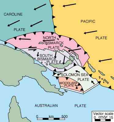
New Ireland lies on the North Bismarck Plate, one of a group of microplates caught in the collisional zone between the Pacific and Australian Plates. New Britain lies on the South Bismarck Plate, another of these microplates. The 29 July Earthquake appears to have occurred on one of a number of transform faults (faults where two tectonic blocks are moving past one-another horizontally) between these two microplates that cross eastern New Britain and southern New Ireland. This faulting is caused by an area of rifting (movement apart by two tectonic plates, with new crust being formed between them) to the north of New Britain and west of New Ireland, which is pushing the eastern part of the South Bismarck Plate southward with regard to the North Bismark Plate.