Showing posts with label Peru South America. Show all posts

Sunday, 24 July 2022

Mesolithic microliths from Gujarat State, India.

The term 'microlith' was first coined by the English archaeologist Archibald Campbell Carlyle, to describe small retouched stone blades generally thought to have been part of a larger tool, while he was working in the Vindhya Hills of central India in the 1860s. Here these items were produced from about 45 000 years ago onwards, with Pleistocene examples being referred to as 'Late Palaeolithic' and Holocene examples as 'Mesolithic'. The term was later applied to a wide range of similar small tools at sites around the world, and became the defining tool for separating Mesolithic from earlier technologies. 

The term is now used to cover a wide range of small stone tools with a wide variety of uses, with a confusing variety of descriptions. These tools appear at different times in different places, but are found on every inhabited continent by the end of the Pleistocene. The use of these tools persisted through the Neolithic and Bronze ages, and in some parts of the world into the modern era, making their use as a dating tool limited without a good understanding of local history.

In India, these tools were used by a wide range of semi-nomadic peoples engaging in hunting, gathering, fishing, and foraging, over a long time period that saw the arrival of the first Human inhabitation of the Ganga plains, the West Bengal delta, the Indian west coast and Kerala. Microlithic tools appear to have been used for a huge range of activities during this time, but there was no single microlith-producing culture or technology, but rather a vast range of peoples making and using microlithic tools over a long period of time.

The Thar Desert, which covers large areas of Rajastan and Gujarat states in India and Sindh Province in Pakistan, contains thousands of relic dunes (dunes which have no present day source of sand) with scatters of microlithic tools on their tops. These dunes typically overlook bodies of water, such as lakes or rivers, and which may be permanent or seasonal. Studies of the local geography suggest that these waterways date to the latest Pleistocene, at which time the dunes were still active. This was associated with the development of a wetter climate, with higher rainfall and increased vegetation, which in turn stabilised the dunes. This wetter climate appears to have attracted the first hunter gatherers into the area, resulting in the microliths on the dune tops.

This was not a simple change from a dry to a wetter climate, but a gradual process with bodies of water appearing and then disappearing over a period of several thousand years, which presumably resulted in different groups of people moving into and out of the area over that time. The available evidence appears to support this, with some dunes having successions of different tool-bearing and non-tool-bearing layers up to 150 cm thick. However, few of these sites have had chronologies developed, and there has been almost no work done which correlates any of this material to material elsewhere in India.

In a paper pulished in the journal Plos One on 22 June 2022, Charusmita Gadekar of the Department of Archaeology and Anthropology of the Milà iFontanals Institution for Research in HumanitiesJuan José García-Granero, also of the Department of Archaeology and Anthropology of the Milà i Fontanals Institution for Research in Humanities, and of the School of Archaeology at the University of OxfordMarco Madella of the Department of Humanities at the Universitat Pompeu Fabra, the Institució Catalana de Recerca iEstudis Avançats, and the School of Geography, Archaeology and EnvironmentalStudies, at the University of the Witwatersrand, and Pottentavida Ajithprasad of the Department of Archaeology and Ancient History at the Maharaja Sayajirao University of Baroda, examine the a lithic assemblage from Vaharvo Timbo, a dune-top archaeological site in the Patan District of Gujarat State, India.

The Vaharvo Timbo site was discovered in the 1980s, and was the subject of an excavation by the North Gujarat Archaeological Project (a collaboration between the Maharaja Sayajirao University of Baroda and the Milà i Fontanals Institution for Research in Humanities) in 2011. The site covers 52 000 m² at the top of a set of stabilised dunes in the estuary of the River Rupal. 

Two trenches were dug during the excavation, both measuring 4 x 4 m. The first of these was on the dune summit, and found a layer 135 cm deep, containing lithic tools and debitage, pieces of ochre, iron or manganese oxide nodules, Dentalium sp. (Tusk Shell) shell beads, bone points, and grinding stones, which was isotope dated to between 5600  and 5000 BC. The second trench was excavated lower on the dune slope, and uncovered a Human burial, containing a young individual and two pottery vessels in the style of the Early Harrapan Period (3300-2600 BC).

Vaharvo Timbo is located about 6 km to the south of the Loteshwar site, which was excavated by the North Gujarat Archaeological Project in 2009. The Loteshwar site produced material dated to 7168–4703 BC, which makes it one of the earliest known Holocene settlements in northwest India, including a wide range of Mesolithic stone tools, as well as traces of the consumption of Animals (principally Antelope) and Plants (principally wild grains and pulses) and charcoal.

Map of western India showing the location of notable archaeological sites in the Thar Desert. Francesc Conesa in Gadekar et al. (2022).

The relatively recent exploration of Loteshwar and Vaharvo Timbo mean that both were excavated in a controlled manner, with the precise location of each lithic item carefully recorded, and directly related to sediment structures, and biological items from which dates can be obtained, allowing direct comparison of the sites.

Gadekar et al.'s study concentrated on the early hunter-gatherer inhabitants of the Thar desert, and therefore concentrated on the material from the trench on the top of the dune, rather than the later burial. The lithic material included 5034 pieces of debitage (waste from the manufacturing of tools), 192 blades (including simple blades with parallel sides, backed blades, obliquely blunted blades, and retouched blades), 90 geometric tools (including isosceles triangles, with two equal sides, scalene triangles, without equal sides, lunates, shaped like a crescent, and trapezes, with two parallel horizontal sides and two non-parallel shorter sides), and 20 non-geometric tools (including points and double-sided scrapers). The material from which these tools were made includes chert, chalcedony, banded agate, moss agate, carnelian, bloodstone and quartz. The presence of large amounts of debitage implies that stone tools were being made at the site.

Examples of the lithic assemblage recovered from Vaharvo Timbo: (a)-(j) trapezes, (k)-(l) lunates, (m)-(p) points, (q) triangle isosceles and (r)-(z) various types of blades. Pottentavida Ajithprasad in Gadekar et al. (2022).

The microliths at Loteshwar and Vaharvo Timbo appear to have been made using similar techniques, and both at both sites the assemblage is dominated by blades. However, the Vaharvo Timbo assemblage contains a far higher proportion of retouched blades and geometric tools than that at Loteshwar. Conversely, the Loteshwar assemblage is dominated by blade flakes (flakes without uniform parallel sides like a blade), which are very rare at Vaharvo Timbo.

The Vaharvo Timbo site shows extensive evidence of tool manufacturing, as well as the exploitation of Plant and Animal resources. Ceramics are absent from the site, and, curiously, none of the tools show signs of wear, possibly implying they were being manufactured here for use elsewhere. The tools at Vaharvo Timbo appear to have been made using similar techniques to those at Loteshwar, but the range of tools is more limited. Possibly this reflects Loteshwar, which is located about 500 m from the Khari River, being a more permanent settlement, while Vaharvo Timbo was used as a base for hunting and fishing expeditions.

See also...

Follow Sciency Thoughts on Facebook.

Follow Sciency Thoughts on Twitter.


Saturday, 7 May 2016

Gryposuchus pachakamue: A Gavialoid Crocodylian from the Middle Miocene of Peru.

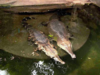
Gavialoid Crocodylians, or Gharails (Gavialoidea), are highly specialized Crocodylians with elongate, slender jaws and eyes and nostrils high on their heads. They are specialists piscavores, adapted to catching Fish rather than more generalist ambush predators like other Crocodylians. Today only a single species is extant, the Indian Gharail, Gavialis gangeticus, but the group has an extensive fossil record, and a contested evolutionary history. Generic studies have suggested that the closest relative of the living Gharail is the Indonesian False Gharial, Tomistoma schlegelii, and that the two probably diverged some time in the Eocene; this fits well with the presence of a number of fossil species assigned to the genus Gavialis in Indonesia, and suggests that the group may have originated in southern Asia at this time. However analysis of the fossil record suggests that Gavialoids diverged from other Crocodylians in the Cretaceous, with primative members of the group appearing in the Late Cretaceous in North America, Europe, and Africa. One possible key to understanding this group are the South American Gavialoids, a group which persisted at least till the Miocene, and which appear to have included advanced forms similar to modern and recent Asian species, as well as more primative members of the group.

In a paper published in the journal PLoS One on 20 April 2016, Rodolfo Salas-Gismondi of the Institut des Sciences de l’Évolution at the Université de Montpellier and the Departamento de Paleontología de Vertebrados at the Museo de Historia Natural at the Universidad Nacional Mayor de San Marcos, John Flynn of the Division of Paleontology at the American Museum of Natural History, Patrice Baby of Géosciences-Environnements Toulouse at the Université de Toulouse, the Institut de reserche pour le developpement and PeruPetro, Julia Tejada-Lara, also of the Departamento de Paleontología de Vertebrados at the Museo de Historia Natural at the Universidad Nacional Mayor de San Marcos and the Division of Paleontologyat the American Museum of Natural History and of the Department of Earth and Environmental Sciences at Columbia University and Julien Claude and Pierre-Olivier Antoine also of the Institut des Sciences de l’Évolution at the Université de Montpellier, describe a new species of Gavialoid Crocodylian from the Middle Miocene Pebas Formation of Peru.

The Pebas formation was laid down in an extensive wetland system formed by the drainage of an ancient riverway from what is now the Amazon Basin running west into the Pacific Ocean. This ancient west-flowing Pebas river system has been replaced by the modern east-flowing Amazon river system due to the formation of the Andes mountains, driven by subduction of the Nazca Plate beneath the South American Plate along the west coast of South America.

The new species is placed in the previously described South American genus Gryposuchus, and given the specific name pachakamue, Pachakamue being a Quechua god who was the first storyteller and who preserved ancient knowledge about the origin of living things in Amazonia. The species is described from an almost complete skull, slightly distorted around the right orbit abd lacking most of the temporal and occipital bones, as well as the pterygoid flanges, plus nine less complete skulls, which together give a good impresion of the head of the animal, thought the post-cranial skeleton is unknown.

Gryposuchus pachakamue. Photograph and schematic drawing of the skull in dorsal (A), ventral (B), and lateral (C) view. (D) Photograph of the right mandible and schematic drawing in dorsal view. Details of the skull (E,F). (E) In lateral view. (F) In occipital view. Abbreviations: an, angular; ar, articular; bo, basioccipital; d, dentary; d4, d22, dentary tooth positions; ec, ectopterygoid; ec.j, jugal surface for ectopterygoid; ec.mx, maxilla surface for ectopterygoid; EN, external nares; eo, exoccipital; f, frontal; fo, foramen; IF, incisive foramen; j, jugal; j.mx, maxilla surface for the jugal; l, lacrimal; ls, laterosphenoid; m22, maxillary tooth position 22; mcq, medial condyle of the quadrate; mx, maxilla; mx. j, jugal surface for maxilla; n.mx, maxilla surface for nasal; n, nasal; OR, orbit; p, parietal; pa, palatine; pf, prefrontal; pm, premaxilla; p2, premaxillary tooth position 2; po, postorbital; ppo, paraoccipital process; pt, pterygoid; ptb, pterygoid bullae; q, quadrate; qj, quadratojugal; qj.q, quadrate surface for quadratojugal;; rac, retroarticular crest; sp, splenial; sa, surangular; so, supraoccipital; sq, squamosal; SOF, suborbital fenestra; STF, supratemporal fenestra. Scale bars are 5 cm. Salas-Gismondi et al. (2016).

Gryposuchus pachakamue is a long-snouted Gavialoid with 22 mandibular (lower) teeth plus 22 maxilary and four premaxilary teeth (i.e. 26 upper teeth) on each side of the mouth. The number of premaxilary teeth is the same as in other members of the genus Gryposuchus, all of which have four on eact side, while all members of the genus Gavialis have five premaxilary teeth on each side.

A phylogenetic analysis carried out by Salas-Gismondi et al. suggests that these two advanced Gavialoid genera (Gryposuchus and Gavialis) are in fact closely related. This supports the idea of a modern Asian, origin of modern Gavialoids, some of which then migrated to South America, probably along the ancient Tethys Seaway and across a narower Atlantic to the Caribbean and then the Pebas River Basin. Earlier 'primitive' South American Gavialoids are suggested to be the results of an earlier radiation within the group, more closely related to other 'primative' forms elsewhere than to Gryposuchus.

 Time calibrated phylogenetic tree of the Gavialoidea and relevant paleogeographic distributions associated with the evolution and diversification of gavialoids in marine and freshwater settings. During the Late Paleocene-Early Eocene interval, peaks of sea surface temperature (SST) and global sea surface level (GSL) occurred together with tropical marine connections through the Tethys Ocean and Caribbean Sea. During the Neogene, distinct biomes dominated tropical South America: (A) Acre Phase, after the onset of the eastern-draining Amazon and northward-draining Orinoco river systems; and (B) Pebas Mega-Wetland System, with its drainage northward to the Caribbean Sea. Abbreviations: Olig., Oligocene; Ple., Pleistocene; Pli., Pliocene. Salas-Gismondi et al. (2016).

See also...

http://sciencythoughts.blogspot.co.uk/2015/02/dwarf-crocodile-remains-from.htmlDwarf Crocodile remains from the Oligo–Miocene of northwestern Queensland.            The Mekosuchine Crocodile Mekosuchus whitehunterensis was described from Late Oligocene deposits exposed at the White Hunter Site in the Riversleigh World Heritage Area innorthwestern Queensland. It is interpreted to have been largely terrestrial, and to have been a dwarf...
http://sciencythoughts.blogspot.co.uk/2014/03/a-new-species-of-crocodile-from-west.htmlA new species of Crocodile from West Africa.                                                                         The Slender-snouted Crocodile, Mecistops cataphractus, is found throughout West and Central Africa. It is the only species in the genus Mecistops, which apparently diverged from the related genus Osteolaemus in the Miocene. The species is...
Follow Sciency Thoughts on Facebook.