Monday, 20 July 2015

Barbatodon transylvanicus: A red-toothed Multituberculate Mammal from the Late Cretaceous of Haţeg Island.


Small, isolated islands often produce distinctive faunas, unlike anything seen on larger landmasses, and have been termed ‘cradles of evolution’ for this reason. Such island faunas are also known in the fossil record, particularly during the Cainozoic, with examples such as the Dwarf Hominids of Flores Island in Indonesia, Pygmy Elephants and Giant Hedgehogs from the Mediterranean and Pygmy Elephants from the Channel Islands of California. Further back in the fossil record distinct landmasses are harder to identify, but one well documented case is Haţeg Island in the modern Transylvanian Basin of southern Romania, where high sea-levels in the Late Cretaceous flooded much of southern Europe. Haţeg Island is estimated to have been about the same size as modern Hispaniola, and has produced a variety of unique Dinosaurs, including Dwarf Sauropods, and a Mammalian fauna dominated by the Kogaionid Multituberculates, an unusual group of Mammals found nowhere else during the Cretaceous, but being one of two Mammal groups in Europe which survived the End Cretaceous Extinction, flourishing briefly during the Palaeocene before becoming extinct as more modern Mammal Faunas invaded Europe from elsewhere (the other group being the equally extinct Adapisoriculidae, tree dwelling Placental Mammals). The lifestyle of Kogaionids, like many other Multituberculates, is somewhat obscure, as most species are known only from isolated teeth, but they are thought to have been similar to modern Rodents or Insectivores.

In a paper published in the journal PLoS One on 15 July 2015, Thierry Smith of the Directorate Earth and History of Life at the Royal Belgian Institute of Natural Sciences and Vlad Codrea of the Faculty of Biology and Geology at University Babeş-Bolyai describe a partial skull of the Kogaionid Multituberculate Barbatodon transylvanicus, previously known only from a single lower molar, from the Late Cretaceous of Haţeg Island.

The new specimen comprises a partial rostrum (snout), the left premaxillary, the left squamosal, both petrosals, and both associated dentaries, along with attached teeth, as well as a number of detached teeth. This allows conformation that Barbatodon transylvanicus is in fact a true species, and not a specimen of Kogaionon ungureanui, as has been previously suggested.

Barbatodon transylvanicus, Maastrichtian, Pui, Romania, specimen UBB P-Mt 1. Partial skull in (A) dorsal, (B) ventral, (C) left lateral, (D) right lateral views; Left squamosal and petrosal (E) and right petrosal (F) in dorsal view; Left premaxillary in (G) lateral view; Left dentary in (H) occlusal, (I) labial, (J) lingual views; Right dentary in (K) occlusal, (L) labial, (M) lingual views. Specimens covered with ammonium chloride. Smith & Codrea (2015).

The crowns of the teeth of Barbatodon transylvanicus are tinted red with iron oxide minerals. This is seen in modern Red-toothed Shrews (Soricinae and Myosoricinae) as well as a variety of Rodents, such as the Brown Rat, Rattus norvegicus, and North American Beaver, Castor canadensis, as well as in some non-Mammals, such as the Axolotl, Ambistoma spp., Piranhas, Characidae, Butterflyfish, Chaetodonidae, and even some Molluscs such as the Limpet, Patella, and the Chiton, Acanthopleura. In all cases the presence of iron minerals is thought to add strength and durability to the teeth, for example in Butterflyfish more iron minerals are associated with a higher Coral content in the diet.

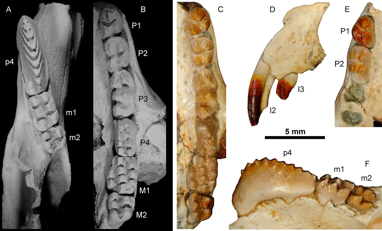
Close-up on tooth rows of Barbatodon transylvanicus. (A) Left dentary with p4-m2 and (B) left maxillary with P1-M2 in occlusal views and covered with ammonium chloride. (C) Left maxillary with P1-M2 in occlusal view; (D) premaxillary with in I2-3 in lateral view; (E) anterior part of right maxillary with P1-2 and (F) right dentary with p4-m2 in lingual view in natural colour. Smith & Codrea (2015).

Iron minerals have previously been identified in the teeth of the Paleocene Asian Taeniolabidoid Multituberculates Lambdopsalis bulla and Sphenopsalis nobilis, suggesting that this may be an ancestral trait found throughout the group, as with Red-toothed Shrews. However in Rodents the trait is thought to have arisen separately on numerous occasions (different iron minerals are found in different Rodent groups), so without further data no such assumption can be made. Tooth enamel is seldom preserved without alteration, and this is the first known example of iron minerals being preserved within the enamel of teeth from any Mesozoic animal, making it unlikely that it will ever be established how widespread this trait was in the largely-Cretaceous Multituberculates.

Reconstruction of the skull and dentary of Barbatodon transylvanicus in (N) dorsal and (O) lateral views. Grey zones indicate missing parts. Smith & Codrea (2015).

See also…

Shrews (Soricidae) are small insectivorous or omnivorous Mammals found across much of the...


Biologists studying modern mammals divide them into...

During the later part of the Cretaceous global sea levels were extremely high, and much of Europe was flooded, leaving he remaining land masses as a string of...


Follow Sciency Thoughts on Facebook.

Sunday, 19 July 2015

Landslide kills three on Pune-Mumbai Expressway in Maharashtra State, India.

Three people have been confirmed dead and another two are being treated for injuries following a landslide that struck the Pune-Mumbai Expressway close to the Adoshi Tunnel in Maharashtra State, India, at about 12.15 pm local time on Sunday 19 July 2015. Debris fell on both lanes of the expressway, with three vehicles being struck and partially buried on the Mumbai-bound side of the road. Traffic towards Pune was able to move again from about 1.30 pm local time, but the Mumbai-bound lane remains closed, with traffic being diverted to the old Mumbai-Pune Highway, and extra trains being run between the cities in an attempt to slow the buildup of congestion.

A damaged car and boulders on the Pune-Mumbai Expressway following the 19 July 2015 landslide. Times of India.

The area where the incident occurred is known to suffer a high risk of landslides, particularly during the  monsoon season when high rainfall frequently triggers such events. Landslides are a common problem after severe weather events, as excess pore water pressure can overcome cohesion in soil and sediments, allowing them to flow like liquids. Approximately 90% of all landslides are caused by heavy rainfall. To this end the slopes above the expressway had been re-enforced against such events. However local press sources are reporting that these defenses are largely iron in construction, and in places are showing signs of severe corrosion.

The approximate location of the 19 July 2015 Pune-Mumbai Expressway landslide. Google Maps.

Maharashtra State has a monsoon climate, with the rains typically arriving around the start of June and peaking in July. The area where the 19 July 2015 landslip occurred typically receives over 500 mm of rain in June and over 1300 mm in July, and the area suffers frequent landslip and flooding events. This situation is made worse by widespread deforestation and quarrying for construction materials (much of it illegal) which tends to destabilize hill slopes.

Monsoons are tropical sea breezes triggered by heating of the land during the warmer part of the year (summer). Both the land and sea are warmed by the Sun, but the land has a lower ability to absorb heat, radiating it back so that the air above landmasses becomes significantly warmer than that over the sea, causing the air above the land to rise and drawing in water from over the sea; since this has also been warmed it carries a high evaporated water content, and brings with it heavy rainfall. In the tropical dry season the situation is reversed, as the air over the land cools more rapidly with the seasons, leading to warmer air over the sea, and thus breezes moving from the shore to the sea (where air is rising more rapidly) and a drying of the climate. This situation is particularly intense in South Asia, due to the presence of the Himalayas. High mountain ranges tend to force winds hitting them upwards, which amplifies the South Asian Summer Monsoon, with higher winds leading to more upward air movement, thus drawing in further air from the sea. 

Diagrammatic representation of wind and rainfall patterns in a tropical monsoon climate. Geosciences/University of Arizona.

See also...

Five people have reportedly died following a landslide which destroyed the home in which they were staying in the village of Mohechiwadi in the Raigad District...


At least 41 people have died and between 120 and 350 are missing after a landslide destroyed the village of Malin, about 80 km north of Pune in Maharashtra State, on the morning of Wednesday 30 July 2014...

Parts of the Indian city of Mumbai are suffering from flooding after being hit by a series of freak waves on Thursday 12 June 2014. The waves occurred around high tide, and rose over four meters above expected levels, inundating low lying coastal parts of the city...


Follow Sciency Thoughts on Facebook.

Asteroid (385186) 1994 AW1 passes the Earth.

Asteroid (385186) 1994 AW1 passed by the Earth at a distance of 9 725 000 km (25.3 times the average distance between the Earth and the Moon, or 6.50% of the average distance between the Earth and the Sun), at about 2.20 pm GMT on Wednesday 15 July 2015. There was no danger of the asteroid hitting us, though had it done so it would have presented a considerable threat. (385186) 1994 AW1 has an estimated equivalent diameter of 570-1800 m (i.e. it is estimated that a spherical object with the same volume would be 570-1800  m in diameter), and an object of this size would pass through the atmosphere and directly impact the ground with a force of about 10 000-1 500 000 megatons (roughly 588 000 to 8 820 000 times the explosive energy of the Hiroshima bomb), causing devastation over a wide area and creating a crater about 8-20 kilometers across, and resulting in global climatic problems that could last for decades or even centuries.

The calculated orbit of (385186) 1994 AW1. JPL Small Body Database.

(385186) 1994 AW1 was discovered on 11 January 1994 by astronomers Kenneth Lawrence and Eleanor Helin at the Palomar Observatory in California. The designation 1994 AW1 indicates that it was the 47th asteroid (asteroid W1) discovered in the first half of January 1994 (period 1994 A), while the numeral 385186 indicates that it was the 385 186th asteroid ever discovered; asteroids are not given this numeric designation immediately, to avoid false or double sightings being given numbers, but rather wait until the existence of the body has been confirmed by multiple observations.

(385186) 1994 AW1 has a 424 day year orbital period and an eccentric orbit tilted at an angle of 24.1° to the plane of the Solar System that takes it from 1.02 AU from the Sun (i.e. 102 % of the average distance at which the Earth orbits the Sun) to 1.18 AU from the Sun (i.e. 118% of the average distance at which the Earth orbits the Sun). It is therefore classed as an Amor Group Asteroid (an asteroid which comes close to the Earth, but which is always outside the Earth's orbit). This means that close encounters between the asteroid and Earth are fairly common, with the most recent having occurred in February this year next predicted in December. As an asteroid probably larger than 150 m in diameter that occasionally comes within 0.05 AU of the Earth, (385186) 1994 AW1 Icarus is also classified as a Potentially Hazardous Asteroid (it comes no closer to the Sun than 102% of the average distance at which the Earth orbit's the Sun, but the Earth's orbit is not completely circular). (385186) 1994 AW1 is also thought to be a potential binary asteroid, i.e. it is thought likely that this body has a small moon orbiting it.

See also...

Asteroid (1566) 1949 MA Icarus passed by the Earth at a distance of 8 054 000 km (20.9 times the average distance between the Earth and the Moon, or 5.38 % of the average distance between the Earth and the...


Asteroid (429094) 2009 SG2 passed by the Earth at a distance of 13 140 000 km (44.4 times the average distance between the Earth and the Moon, or 11.4 % of the average distance between the Earth and the...


Asteroid (90416) 2003 YK118 passed by the Earth at a distance of 11 700 000 km (30.4 times the average distance between the Earth and the Moon, or 7.82 % of the average distance between the Earth and the...


Follow Sciency Thoughts on Facebook.

Carcharocles megalodon: Did the Megashark get bigger over time?


The largest Shark ever to live was Carcharocles megalodon, which reached sizes of about eighteen meters and survived from the Middle Miocene until the end of the Pliocene. This was formerly thought to be closely related to the living Great White Shark, Carcharodon carcharias, and was placed in the same genus (i.e. known as Carcharodon megalodon), but is now recognized as a member of the extinct family Otodontidae, collectively known as the Megatooth Sharks. The Megashark was a remarkably long-lived species (or morphospecies, since it is impossible to tell whether members of an extinct ‘species’ could have reproduced together, but we can tell they were the same size and shape, and presumably filled the same ecological niche), surviving for around 13.3 million years, and had a global distribution, which makes it possible to study these Sharks over both a long period of time and a wide geographical range, potentially enabling palaeobiologists to understand what, if any, evolutionary pressure the species was under while it was alive.


In a paper published in the journal Paleobiology on 4 June 2015, Catalina Pimiento of the Florida Museum of Natural History and Department of Biology at the University of Florida and Smithsonian Tropical Research Institute, and Meghan Balk of the University of New Mexico examine a large selection of Megashark teeth from museum collections in order to determine whether the species changed in size over its long fossil record. Lamniforme Sharks (‘Mackerel Sharks’ – the wider group that includes both the extinct Megasharks and living Great White Sharks) show heterodont dentition, that is to say their teeth are not all the same, and it is possible to determine which jaw a tooth came from and where on that jaw it sat through morphometric analysis (a mathematical analysis which compares the ratios of different measurements on a bone, tooth or shell). This enables direct comparison of isolated teeth from different parts of the mouth, and the calculation of the overall size of the living Shark from such teeth.

Size, as well as being the most obvious and dramatic characteristic feature of species such as the Megatooth Sharks, is an important indicator of ecological role, and therefore useful for comparing specimens assigned to the same species collected from widely different places and times. All Megatooth Sharks are thought to have been apex predators (i.e. they were the largest predators in their environments, lacking anything which might have fed on them), and the comprises a series of chronospecies (species which replace one-another over time, and which are thought to have evolved into one-another rather than dying out) which grow progressively in time, culminating in the Megashark. This is roughly what is expected from marine apex predators, as larger animals are able to tackle a wider range of prey without becoming more vulnerable to attack by predators higher up the food chain. Based upon this observation Pimiento and Balk predicted that the species Carcharocles megalodon was likely to have grown over time.

Schematic representation of the changes in tooth morphology within the megatooth lineage: cusplet loss, broadening of tooth crowns, and size increase. Pimiento & Balk (2015).

Pimiento and Balk were able to examine a large number of teeth from collections around the world online (i.e. without the need to visit widely-distributed museums personally, which could have taken years). Teeth which were heavily worn, and therefore could have been reworked (i.e. buried once, then eroded out of sediments, relocated and reburied) were excluded from the study, as were teeth which could not be dated with a reasonable level of accuracy. This meant that some areas where the Megashark was known to be present were excluded from the end results of the study, notably northern Europe and Africa, while other areas where severely under-represented, particularly the tropical Atlantic and Caribbean, and Indian Ocean.


The results were sorted into three broad time categories of approximate equal length, the Middle Miocene, Late Miocene and Pliocene, as well as the Northern and Southern Hemispheres and Atlantic, Pacific and Indian Ocean Basins.

Contrary to the predicted outcome, the species Carcharocles megalodon did not appear to grow over time, with the largest specimens from the Pliocene being approximately the same size as the largest Middle Miocene specimens. However the distribution of sizes did vary over time, with a wide distribution of tooth sizes in the Middle Miocene and a heavy skewing towards larger specimens in the Late Miocene and Pliocene. There was also a slight difference in the size of Sharks from different locations, with Sharks from the Southern Hemisphere being slightly larger in the Middle and Late Miocene, but not the Pliocene.

It is possible that the distribution of sample sizes has been affected by sampling bias, as larger Sharks teeth are more attractive to collectors than smaller teeth. In particular Pimiento and Balk note that one of the largest collections from the Southern Hemisphere, originating from the Bahia Formation in Chile, is made up largely of specimens confiscated from an illegal trade in the teeth, and that this is likely to have pushed the average size of Southern Hemisphere specimens upwards.

The early attaining of the maximum size by Carcharocles megalodon strongly suggests that the species was unable to grow any larger. The genetic and physiological underpinning of size in Sharks is not well understood, but clearly there must be a maximum size which can be reached without dramatic physiological change not possible through gradual genetic drift, and it is likely that the Megashark reached this size very early in its history.

The preference for larger specimens later in the species history may be a result of sampling bias, but may also be a result of evolutionary pressure favouring larger Sharks. This is not beyond the bounds of possibility, as many Lamniforme Sharks give birth to live young rather than laying eggs, and larger Sharks are able to give birth to larger offspring, giving these juveniles a head start in achieving larger sizes themselves; since large predatory Sharks are typically willing to eat smaller members of their own species there is a distinct advantage in an apex predator Shark reaching its maximum size quickly.

Under this scenario the species reached its maximum possible size early in its 13.3-million-year history, being simply unable to grow beyond about 18 m due to biological constraints. However the species was still subject to ecological pressures favouring larger specimens, and over time a wide size distribution was replaced with a narrower distribution, with the Megashark population dominated by larger individuals.

See also…

The deepest evolutionary split in the jawed vertebrates (Gnathostomes) is that between the Sharks (Chondrichthyes) and Bony Fish (Osteichthyes), with all terrestrial vertebrates forming a subgroup within...


The Main Devonian Field outcrops on the northwestern East European Platform in Estonia, Latvia, Lithuania, northern Belarus...


Palaeontological studies of the Arctic during the Early-to-Middle Eocene have revealed a world in which the ice-free Arctic Ocean was surrounded by lush warm-temperate rainforests, inhabited by creatures such...


Follow Sciency Thoughts on Facebook.

Saturday, 18 July 2015

Collapse kills at least six at Philippine coal mine.

Six mine workers have been confirmed dead following a collapse at the Semirara Mining and Power Corporation operated Panian Coal Mine on Semirara Island in Antique Province, the Philippines, which occurred on Friday 17 July 2015. Another three miners are still missing following the event. All of the workers were part of a team of thirteen working at a coal face at the open-pit mine, when the face collapsed in a landslide-like event. Four of the team were able to escape, but the remaining nine were buried and it is not thought likely that any have survived. The miners confirmed dead have been identified as Alexander Nudo, Arnold Omac, Ricardo Panes, Dicson Daupan, Bernie Manrique, and Jeneroso Talaro, while those still missing have been named as Danilo Bayhon, Noel Penolla, and Ian Catulay.

Damaged equipment in the aftermath of the 17 July 2015 Panian Mine collapse. Bea Zaragosa/ABS-CBN News.

The cause of the collapse is unclear at this time, but thought likely to be related to high rainfall in the days before the event. Landslides are a common problem after severe weather events, as excess pore water pressure can overcome cohesion in soil and sediments, allowing them to flow like liquids. Approximately 90% of all landslides are caused by heavy rainfall. The Department of Energy has ordered operations at the mine to be suspended until an enquiry into the deaths has been carried out.

The approximate location of the Panian Coal Mine.Google Maps.

Open pit mines cover much of the northern half of Semirara Island, and have been a focus of concern for environmental and human rights groups. The mines are a major source of revenue, as well as providing employment and fuel for generating electricity in the Philippines developing economy. However the Semirara Mining and Power Corporation has been accused of land-grabbing practices which have displaced hundreds of seaweed planters, fishermen and farmers from their traditional homes and lands, and of destroying important local ecosystems, in particular the islands mangroves which are considered part of a biodiversity hotspot. The mines also have a checkered safety history, with ten workers having been killed in a similar collapse in February 2013.

See also...

A miner has died after being buried by a mudflow at a mine in Benguet on Luzon Island in the Philippines on Sunday 22 December 2013. Rogelio Guleng (55) was working in a tunnel 782 m bellow the surface at the Philex Mining operated Padcal Mine when he was buried by a mud discharge. He was dug out...


One person is known to have died and another is missing after a landslide on a spoil heap struck a...


A soldier and a militiaman have died after being shot by unknown assailants near a camp in the Kiblawan Municipality in Davao del Sur Province on Mindanao Island in the Philippines at about 8.00 am local time...


Follow Sciency Thoughts on Facebook.

Magnitude 1.3 Earthquake off the east coast of Jersey.

The British Geological Survey recorded a Magnitude 1.3 Earthquake at a depth of 4 km, roughly 15 km to the east of the island of Jersey in the Channel Islands slightly before 2.50 am British Summertime (slightly before 3.50 am GMT) on Sunday 12 July 2015. Although large for the area, the quake was still to small to present any threat to human activity, and there were no reports of any damage or injuries relating to this event, though it was reportedly felt on the island.

The approximate location of the 12 July 2015 Jersey Earthquake. Google Maps.

The precise cause of Earthquakes around the UK can be hard to determine; the country is not close to any obvious single cause of such activity such as a plate margin, but is subject to tectonic pressures from several different sources, with most quakes probably being the result of the interplay between these forces.

Britain is being pushed to the east by the expansion of the Atlantic Ocean and to the north by the impact of Africa into Europe from the south. It is also affected by lesser areas of tectonic spreading beneath the North Sea, Rhine Valley and Bay of Biscay. Finally the country is subject to glacial rebound; until about 10 000 years ago much of the north of the country was covered by a thick layer of glacial ice (this is believed to have been thickest on the west coast of Scotland), pushing the rocks of the British lithosphere down into the underlying mantle. This ice is now gone, and the rocks are springing (slowly) back into their original position, causing the occasional Earthquake in the process. 

Simplified diagram showing principle of glacial rebound. Wikipedia.

Glacial rebound seems an unlikely cause of Earthquakes beneath the Channel Islands, an area that was never glaciated, but this is not entirely the case. The northwest of Scotland is rising up faster than any other part of the UK, but the Earth's crust onland in the UK is fairly thick, and does not bend particularly freely, whereas the crust beneath the Channel is comparatively thin and more inclined to bend under stress. Thus uplift in Scotland can cause the entire landmass of Great Britain to pivot, causing movement in the rocks beneath the Channel.

Map showing areas of the British Isles currently rising or sinking as a result of glacial rebound. Wikipedia.

Witness accounts of Earthquakes can be useful to geologists trying to understand the processes that cause them and the rocks beneath the surface. If you felt this quake (or if you were in the area but did not feel the quake, which is also useful information) then you can report it to the British Geological Survey here.

See also...

The British Geological Survey recorded a Magnitude 3.0 Earthquake at a depth of 10 km, roughly 22 km to the southwest of the island of Jersey in the Channel...


The British Geological Survey recorded a Magnitude 1.9 Earthquake at a depth of 6 km, roughly 15 km to the southwest of the island of Jersey in the Channel...


The British Geological Survey recorded a Magnitude 1.8 Earthquake at a depth of 7 km beneath the eastern part of the island of Jersey in the Channel Islands...


Follow Sciency Thoughts on Facebook.

Asteroid 2011 YC29 passes the Earth.

Asteroid 2011 YC29 passed by the Earth at a distance of 9 438 000 km (24.5 times the average distance between the Earth and the Moon, or 6.31% of the average distance between the Earth and the Sun), at about 10.10 am GMT on Wednesday 15 July 2015. There was no danger of the asteroid hitting us, though had it done so it would have presented a considerable threat. 2011 YC29 has an estimated equivalent diameter of 71-230 m (i.e. a spherical body with the same mass would be 71-230 m in diameter, and an object towards the upper end of this range would pass through the atmosphere and directly impact the ground with a force of about 400 megatons (about 23 500 times the explosive energy of the Hiroshima bomb), causing devastation over a wide area and creating a crater over 3.5 kilometers across, and resulting in global climatic problems that could last for decades or even centuries.

The calculated orbit of 2011 YC29. JPL Small Body Database.

2011 YC29 was discovered on 29 December 2011 by the University of Arizona's Mt. Lemmon Survey at the Steward Observatory on Mount Lemmon in the Catalina Mountains north of Tucson. The designation 2011 YC29 implies that it was the 728th asteroid (asteroid C29) discovered in the second half of December 2011 (period 2011Y). 

While 2011 YC29 occasionally comes near to the Earth, it does not actually cross our orbital path. It has an elliptical 498 day orbit, at an angle of 23.1° to the plane of the Solar System, that takes it from 1.04 AU from the Sun (1.04 times the average distance at which the Earth orbits the Sun), slightly outside our orbit, to 1.42 AU from the Sun, (1.42 times the distance at which the Earth orbits the Sun and slightly less than the distance at which the planet Mars orbits the Sun). As a Near Earth Object that remains strictly outside the orbit of the Earth it is classed as an Amor Family Asteroid. This means that close encounters between the asteroid and Earth are extremely common, with the last having occurred in January 2012 and the next predicted in December this year.

See also...

Asteroid 2015 JH2 passed by the Earth at a distance of 11 830 000 km (30.8 times the average distance between the Earth and the Moon, or 7.91 % of the average distance between the Earth and the Sun), slightly before 2.40 am GMT on Thursday 9 July...


Comet C/2014 Q1 (PANSTARRS) reached its perihelion (the closest point on its orbit to the Sun) on Monday 6 July 2015, when it was 0.31 AU from the Sun (i.e. 0.31 times the average distance at which the...


Asteroid 2015 MX103 passed by the Earth at a distance of 4 389 000 km (11.4 times the average distance between the Earth and the Moon, or 2.93% of the average distance between the Earth and the Sun), slightly before 4.45 pm GMT on Monday 22 June...


Follow Sciency Thoughts on Facebook.