Patagonia lies at the southern tip of the Americas, and was one of the last areas to have been settled by Humans, who did not arrive there until the end of the Pleistocene. The area has a unique environment, which would have presented challenges to the people settling there. It also has a climate particularly suitable for the preservation of archaeological remains, making it particularly interesting to archaeologists. The area has extensive rock art, but to date little of this has been accurately dated.
In a
paper published in the journal
Science Advances on 14 February 2024,
Guadalupe Romero Villanueva of the
Instituto Nacional de Antropología y Pensamiento Latinoamericano,
Marcela Sepúlveda of the Department of Social Sciences at the
Universidad de Tarapacá, José Cárcamo-Vega of the Laboratorio de Espectroscopía Vibracional at the
Universidad de Chile,
Alexander Cherkinsky of the
Center for Applied Isotope Studies at the
University of Georgia,
María Eugenia de Porras of the
Instituto Argentino de Nivología, Glaciología y Ciencias Ambientales, and
Ramiro Barberena of the
Centro de Investigación, Innovación y Creación at the
Universidad Católica de Temuco, and the
Instituto Interdisciplinario de Ciencias Básicas at the
Universidad Nacional de Cuyo, present dates for four pieces of rock art from the Cueva Huenul 1 archaeological site in Neuquén Province, in the northern part of Argentinian Patagonia, and discuss the implications of this for the early peopling of the region.
The Cueva Huenul 1 archaeological site is located a kilometre above sealevel, to the east of the Andes amid the inland deserts of northern Patagonia. The Andes present a major topographic barrier, preventing the prevailing westerly winds from carrying moisture from the Pacific to the South American Arid Diagonal, where the Cueva Huenul 1 site is located. Precipitation in the region is between 150 mm and 200 mm each year, 75% of which falls in the winter. Rainfall tends to be higher in the west, closer to the Andes, and dryer to the east. with more abundant vegetation in areas with higher rainfall.
Location of Cueva Huenul 1, other sites with rock art in northern Neuquén Province (Argentina), and palaeoecological sites from northwestern Patagonia. María Eugenia de Porras in Villanueva et al. (2024).
The Cueva Huenul 1 site is a cave with a habitable area of 620 m³, formed by the erosion of ignimbrites of the Tilhué Formation beneath an overlying basalt layer of the El Puente Formation, which have not eroded and now form the ceiling of the cave. Excavations within this cave have produced over 5500 lithic artifacts, principally flaked stone objects, and 8800 bone specimens, mostly Guanaco, Lama guanicoe. The site also has a long, and well-defined dating sequence, spanning 12 000 years, with a number of discrete phases of activity identified. The microenvironment within the cave appears to have remained stable and dry over this period, allowing for the excellent preservation of items such as Animal dung, and plant remains.

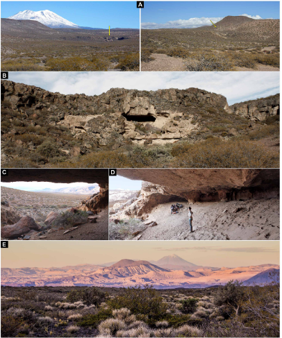
Cueva Huenul 1 environment and landscape. (A) emplacement of Cueva Huenul 1 (yellow arrow) in a volcanic landscape within the Monte desert. (B) to( D) Views of the cave’s geology and topography. (E) View from Cueva Huenul 1 of the volcanic landscape of northwestern Patagonia. Guadalupe Romero Villanueva in Villanueva et al. (2024).
Notably, the Cueva Huenul 1 site has yielded a remarkable quantity of art-related materials, including perforated shell beads, decorated Guanaco bones, and pyro- engraved gourds. Also found inside the cave was a pit-structure containing a large number of twigs from the desert shrub Senna aphylla, which have been stained with red ochre. A large amount of pigments, of various colours and in varying states of preparation.
Cueva Huenul 1 site plan and special findings. (A) excavation units at ch1. (B and C) General and detailed view of pit structure filled with vegetal remains of Senna aphylla stained with red ochre. (D) Pyro-engraved gourd. (E) Perforated shell bead. (F) decorated guanaco (Lama guanicoe) bone. (G) Pigments. each image has an individual metric scale. Guadalupe Romero Villanueva and Ramiro Barberena in Villanueva et al. (2024).
The site has a panoramic view of the surrounding landscape, although it is not visible from any other known archaeological site in the region, nor can any such site be seen from the cave. Other sites in the region include a series of smaller caves and rockshelters, most of which only appear to have been used within the last 2000 years. Some of these, such as El Ciénego and Paso de las Tropas, also have rock art, although it is less diverse in technical style and less formalised than the art at Cueva Huenul 1. The Cueva Yagui site, to the north of Cueva Huenul 1, also records a long timeline, in this case about 8 500 years, and appears to have been more intensely occupied, on the basis of stone tools, abundant ceramics, and faunal remains, with this occupation being particularly intense over the past 2000 years. Both the stratigraphic sequences and the styles of rock art suggest that Cueva Huenul 1, Cueva Yagui, and other sites appear to have been linked.
Cueva Huenul 1 hosts one of the most impressive collections of rock art in northwestern Patagonia, with central portion of the cave’s internal wall and part of the ceiling covered by 895 discrete pieces of rock art, which have been grouped into 466 identifiable motifs. Most of these motifs are geometric shapes rather than pictures, with strokes, dots, circles, and lines being common, and parallel lines, reticulates, polygons, and cruciforms also present, as well as some Human silhouettes and a face, and silhouettes of Guanaco and Choique, Rhea pennata, and some representations of dynamic group activities. A range of colours are used in the cave art, although a haematite-derived red is the most common, along with different hues of white, yellow, and black.
Examples of the rock art of Cueva Huenul 1. Each tracing has a 10cm scale bar. Guadalupe Romero Villanueva in Villanueva et al. (2024).
A large number of motifs are superimposed over earlier artworks, and there appear to be three distinct degrees of weathering, as well as distinct artistic phases. The majority of the art is presumed to be of Late Holocene origin, based upon similarities to styles of art used at other localities. However, the long history of occupation at the site combined with presence of a clear artistic sequence, raises the possibility that some art at the site may be much older.
Four artworks at the Cueva Huenul 1 site were chosen to be dated. These were all classified as 'comb-shapes' based upon a shared basic morphology of a perpendicular horizontal line with several parallel vertical lines extending downwards from it. Within this simple pattern, however, the comb motifs can be divided into simple and complex forms. Three of the motifs examined, UT3- M48, UT5- S4- M7, and UT3- M37, were of the simple type, while the fourth, UT5-S2-M19, was of the complex form. All of the comb motifs are executed in a reddish black pigment. Most are isolated from other artworks, although one (UT5-S2-M19) is part of a complex series of superimposed images from different periods.
Dated rock art paintings from Cueva Huenul 1. (A) Motif Ut3- M37. (B) Motif Ut3- M48. (C) Motif Ut5- S4- M7. Guadalupe Romero Villanueva in Villanueva et al. (2024).
By careful examination of the motifs, Villanueva et al. were able to establish that there was no potentially contaminating organic matter either on, within, or below the paint layer. Three layers were found to be present, the bedrock, the pigment layer, and an overlying layer of translucent particles forming a patina. The pigment layer was identified spectrographically as amorphous carbon; this was found not to contain any significant amount of phosphates, making it unlikely it was derived from carbonized bone.
Dated rock art motif UT5- S2- M19 from Cueva Huenul 1. (A) Original photograph and digital enhancement with DStretch of the complete rock art panel. (B) Original photograph and digital enhancement with DStretch of the dated black comb-shaped motif. (C) digital tracing of the complete rock art panel showing the dated black comb-shaped motif underlaying a series of superimpositions. Guadalupe Romero Villanueva in Villanueva et al. (2024).
Further examination of the samples by Scanning Electron Microscopy and Energy Dispersive X-Ray Analysis demonstrated the presence of plant cells within the pigment layer of all four examined motifs, as well as a composition consistent with a carbonaceous material mixed into an aluminosilicate matrix (i.e. a mixture of charcoal and clay), with the overlying layer of material rich in calcium and sulphur, probably indicating some form of salt. The precise origin of the wood used to make the charcoal was impossible to determine, although it is likely to have been one of the woody shrubs known to have been growing in the region in the Middle Holocene, such as Prosopis spp., Larrea sp., or Schinus sp..

Cross section microphotography of sample CH1-AMS1 embedded in resin showing three differentiated layers. From the bottom, the layers which can be distinguished are; the bedrock support, the black pictorial layer, and a thin layer of patina or varnish. Marcela Sepúlveda and Guadalupe Romero Villanueva in Villanueva et al. (2024).
Based upon this, Villanueva et al. conclude that the black pigment was formed by the incomplete burning of Plant matter, something which should lead a carbon¹⁴ signature. Since there are no long-lived trees in the region, material from which can give misleading date information, the charcoal can be assumed to have come from a short-lived woody C₃ shrub and/or a Cactus (which have their own Crassulacean acid metabolism resulting in a distinctive carbon isotope signature). It was possible to recover sufficient carbon from three of the motifs to be confident that the isotope signature recovered was accurate, while one sample, taken from motif UT5-S2-M19, yielded a much lower amount of carbon, raising concerns that contamination from later sources (this is the motif which is partially overlain by later artworks), leading to this data being excluded from the remainder of the study. The remaining three motifs were found to be between 7728 and 7565 years old (UT3- M48), between 6271 and 6239 years old (UT5- S4- M7), and between 5643 and 5629 years old (UT3- M37).
As well as the dates obtained for the rock art motifs, Villanueva et al. obtained 16 dates from archaeological remains at the site, in order to build up a stratigraphic sequence. This led them to conclude that there had been four stages of occupation at the site, over a period of about 18 000 years.
The first phase is calculated to have lasted approximately 4683 years, from about 17 407 to about 12 934 years before the present. During this phase the cave was occupied by Giant Sloths, with no signs of Human activity.
The second phase is calculated to have lasted approximately 1620 years, from about 11 721 to about 10 162 years before the present, and shows evidence of the first Human activity in the area, including Guanaco bones with cut marks, hearths with charcoal, and a grass bedding structure.
There is then a significant hiatus in activity, with the third phase starting about 8171 years ago and lasting for approximately 3246 years, till about 5074 years before the present. This phase includes the emergence of rock art at the site, with all three dates obtained for the comb motifs falling within this interval, as well as the ochre covered Plant remains. Assuming that the average Human generation time was about 25 years, this would suggest a cultural tradition using similar symbolism which lasted for about 130 generations.
The final phase of activity at the cave includes much more intensive activity, includuing the majority of the rock art, as well as cultural similarities to other sites in the region, and spans about 1500 years in the Late Holocene.
Climatically, the area had a sharper east-west variation in moisture during the Late Pleistocene and Early Holocene, until about 10 000 years ago, with the western Andes being wetter than today, while the eastern Andes were drier. The region to the east of the Andes, inclding the Cueva Huenul 1 site, was significantly more arid than today between about 10 400 and 9 400 years ago. From about 10 000 years ago onwards both the Andes and Eastern Patagonia became extremely arid.
The area reached peak aridity in the Middle Holocene, with widespread deserts and only patchy, fragmented areas of habitable land, which could have acted as stepping stones for the first Humans entering the environment. Large areas would have either too dry for occupation, or too unstable to be entered on more than a temporary basis. Nevertheless, Humans did enter the landscape during this time, probably relocating frequently, and needing to maintain social contact over large distances, while at the same time coming up with innovative technologies for subsistence.
By assembling a comprehensive database of radiocarbon dates for Human activity across the South American Arid Diagonal region, Villanueva et al. conclude that during the period 14 000 to 10 400 years before present the first Human population appeared and rapidly grew, expanding to occupy new niches. From about 10 800 to 7000 years ago a period of cultural stasis appeared, combined with a slowly declining population. The oldest rock art at Cueva Huenul 1 is slightly less that 8000 years old, coinciding with the later part of this period of apparent cultural stasis. The population is also thought to have remained fairly static or shrank across South America between about 9000 and about 5500 years ago.
This suggests that during the Middle Holocene northwestern Patagonia was probably home to a small and scattered population of highly mobile hunter-gatherers, coping with an extremely arid climate with occasional wetter spells. This population was static or shrinking slightly, widely scattered, and having to cope with frequent but unpredictable extreme weather conditions.
The dating of the comb motifs in the rock art of Cueva Huenul 1 gives a date for the origins of rock art in northwestern Patagonia. The repeated nature of these motifs makes it unlikely that these marks were random, with similar marks being repeated several times over a period of about 3000 years, suggesting it was linked to a system for passing information between generations.
Transmission of knowledge can become linked to particular sites, which eventually become key locations for a culture, where people meet to re-enforce cultural identities and maintain extended social networks. Villanueva et al. suggest that Cueva Huenul 1 first became such a culturally important site during the Late Pleistocene, being used regularly over a period of about 1400 years across the End Pleistocene and Early Holocene. Visits to the site continued into the Middle Holocene, though the behaviour of the visitors changed, with the appearance of activities such as marking the walls. During this phase, there is little sign of non-ritual activities, such as food-processing or tool-making. Villanueva et al. suggest that the transition of the space to a ritual centre where these profane activities were not carried out probably implies that the site was not, as previously assumed, abandoned for long periods during the Middle Holocene, but rather underwent a change of purpose connected to its new, sacred status.
Villanueva et al. suggest the emergence of sites such as Cueva Huenul 1 which helped hold widely scattered cultures together would have been key to Human survival in the arid landscape of northwestern Patagonia. The emergence or rock art was probably a way of re-enforcing knowledge transfer across generations, building upon an earlier oral tradition.
The population of many areas in South America apparently struggled to cope with conditions in the Middle Holocene, as increasing aridity fragmented the available liveable spaces, leading to a slowly dwindling population. The first rock art at Cueva Huenul 1 coincides with this period, possibly aiding social cohesion and helping people to survive a particularly harsh period, before populations began to recover between 7000 and 5000 years ago.
The dating of the rock art at Cueva Huenul 1 gives an insight into the context in which such art first appeared in Patagonia. Here, a style of art appears around 8000 years ago and persists for over 3000 years. This happened at a time when the climate was much drier and less predictable than today, at a time when Human populations were at best maintaining stasis, and were probably suffering frequent crashes. It this marginal, sparsely populated environment the rock art apparently helped to preserve collective knowledge across multiple generations.
See also...


.jpg)


%20(1)%20(1).png)


.png)
.png)