Showing posts with label Rock Art. Show all posts

Saturday, 9 August 2025

Officials from the Libyan Tourist Police and Antiquities Protection Agency protecting newly discovered rock art in the Jabal al-Hasawna mountains.

Officials from the Libyan Tourist Police and Antiquities Protection Agency are protecting a series of newly discovered rock engravings in the Jabal al-Hasawna mountains. The rock art was discovered by a Libyan citizen who notified the offices of the agency in Sabha, the nearest city. They are currently under investigation by experts from the Fezzan Antiquities Authority, the Archaeology Department at Sabha University, and the Brak Al-Shati Security Directorate, with a view to determining their historical significance, and how they can best be protected.

Newly discovered rock art in the Jabal al-Hasawna mountains of Libya. Libyan Tourist Police and Antiquities Protection Agency.

The new discoveries include artworks in a number of styles previously described from elsewhere in the Sahara, including art attributed to the Buffalo or Large Wild Fauna Period (so called because the art often features Giant Buffalo, Syncerus antiquus, and other extinct African megafauna). This artwork was created between 12 000 and 8000 BC by hunter gatherer populations living in a still green Sahara, and comprises geometric shapes and images of Animals such as Antelope, Aurochs, Buffalo, Fish, Giraffe, Hippopotamus, Ostrich, and Rhinoceros, painted onto wall panels with clay, manganese, iron oxide, and organic dyes. Examples of Buffalo Period rock art are found across Morocco, Algeria, and Tunisia, and are particularly abundant in the Fezzan Region of southwestern Libya, and around Oued Djerat in the northern part of the Tassili N'Ajjer, Algeria.

Also present is art from the Round Head Period, which was produced by Epipalaeolithic and Mesolithic hunter gatherers from about 7550 to about 5050 BC. Round Head art is painted onto or pecked into rock panel surfaces, and depicts Animals such as Antelope and Barbary Sheep alongside stylised Human figures with rounded heads, often engaged in dancing or other ritual activities. The best known examples of Round Head art come from the Tassili Plateau of southern Algeria, over a thousand kilometres to the southwest of the Jabal al-Hasawna, but examples are also known from the Tadrat Akakas of Libya, and the Djado Plateau of Niger. 

Art from the younger Bovidian, or Pastoral Period, has also been reported. This art style first appears around 6000 BC, and persist to about 700 BC (although most dates to between 5200 and 3800 BC), and contains the first examples of Animal-herding (pastoralism), and depicts Human figures with domestic Animals such as Cattle, Sheep, and Goats, as well as wild Animals such as Antelope, Barbary Sheep, Elephant, and Ostrich. Pastoral Period art contains the oldest known examples of domestic scenes, including women and children, in the Sahara, and is thought to have been made by Neolithic pastoralists migrating seasonally with their herds. The first Pastoral Period art was created while the Sahara was still green, while the latest was made in a desert environment. Over the period the wild Animals depicted in this art reflect this changing climate, as do the locations where it was placed, reflecting changing migration routes as the landscape dried. Examples of Pastoral Period art are common in southwestern Libya and the neighbouring Tassili n'Ajjer area of Algeria.

Younger Horse Period art has also been reported in the Jabal al-Hasawna. This style, dated to between 1200 BC and about 1000 AD, depicts people on Horses and in Chariots, and as well as the first people wearing cloths in Saharan rock art. This style is known from the Tassili n'Ajjer area of Algeria.

Camel Period art appears around 1000 BC and continues to the end of the first millennium BC. This style of art depicts the first Camels in the Sahara, but also domestic Animals such as Cattle and Goats. Men in Camel Period art are often armed with swords, spears, and shields. Examples of Camel Period art are known from Libya, Algeria, and Chad.

See also...

Friday, 5 July 2024

Re-dating the oldest known figurative cave art.

The rock-art left behind by prehistoric cultures has the potential to provide us with insights into the lives of these long-vanished peoples. Dating this art is notoriously difficult. In the past few decades the predominant approach has been the analysis of uranium and its decay products within flowstone layers partially covering ancient art. Flowstone is formed by the deposition of calcium carbonate onto surfaces by evaporating water; typically water that has flowed through limestone deposits then run out onto a surface such as a cave wall or cliff face before evaporating. The most obvious examples of this are stalagmites and stalactites, though many caves have an interior surfaces covered by flowstone. Where these flowstone deposits occur in caves with paintings they will often overlay the artwork, which means that if the flowstone can be dated, then a minimum age for the art can be established (as the art cannot be younger than the flowstone that overlays it).

This method has been used to date ancient art in many parts of the world, including Western Europe, Island Southeast Asia, and Russia. Notably, a hand-stencil in Spain has been dated to 64 800 years before the present, which implies that it must have been made by a Neanderthal artist, although the reliability of the data used in this study has been questioned. The oldest date we currently have for figurative cave art comes from Sulawesi, Indonesia, where an image of a Warty Pig, Sus celebensis, at Leang Tedongnge in the Maros-Pangkep karst has been given a minimum age of 45 500 years.

The methods used to date flowstone samples to date have relied upon dissolving a sample to form a solution, something which will tend to homogenise the sample, averaging the age of multiple layers overlaying a piece of art, and therefore producing a younger age estimation for the art than if the oldest of these layers could be isolated. 

In a paper published in the journal Nature on 3 July 2024, a team of scientists led by Adhi Agus Oktaviana of the School of Humanities, Languages and Social Science at Griffith University, the Pusat Riset Arkeometri of the Badan Riset dan Inovasi Nasional, the Griffith Centre for Social and Cultural Research, and the Center for Prehistory and Austronesian Studies, and Renaud Joannes-Boyau of the Geoarchaeology and Archaeometry Research Group at Southern Cross University, present the results of a study which used laser-ablation uranium-series dating to provide more accurate dates for the Leang Tedongnge image, as well as other examples of cave art in the same region. 

The laser-ablation method enables the targeting of an area 44 μm in diameter, within a laboratory environment. This enables far smaller samples to be collected than with previous methods, which typically involved grinding a sample from the rockface with a rotary tool. With the laser ablation method it is possible to take a polished thin section of rock, and target points upon that, which is both cheaper and less destructive than traditional methods, as well as far more accurate, as it enables specifically targeting the layer of rock directly overlaying the pigment.

Map of the study area. (a) The Indonesian island of Sulawesi, showing the location of the southwestern peninsula (area inside rectangle). (b) South Sulawesi, with the limestone karst area of Maros-Pangkep indicated by blue shading. The locations of cave sites with dated Late Pleistocene rock art were as follows: 1, Leang Bulu’ Sipong 4; 2, Leang Karampuang; 3, Leang Tedongnge; 4, Leang Timpuseng. Oktaviana & Joannes-Boyau et al. (2024).

At the Leang Bulu’ Sipong 4 site in the Maros-Pangkep karst, a 4.5 m wide panel on the rear wall of a cave depicts a number of Human, or Therianthrope (Human-Animal hybrid) figures, interacting with Warty Pigs and Anoas (Dwarf Buffalo), Bubalus sp.. The figures are holding some form of objects, possibly spears or ropes. The artwork may depict a hunting scene, or possibly a visual representation of a myth.

Dated rock art panel at Leang Bulu’ Sipong 4. (a) Photostitched panorama of the rock art panel. Ther, Therianthrope. (b) Tracing of the dated rock art panel showing the results of laser-ablation uranium-series dating. (c) Transect view of the rock art sample BSP4.5 after removal from the artwork, highlighting the paint layer and the three integration zones (ROIs) and associated age calculations. (d) Laser-ablation-multicollector inductively coupled plasma mass spectrometry imaging of the BSP4.5 thorium²³²/uranium²³⁸ isotopic activity ratio. Oktaviana & Joannes-Boyau et al. (2024).

The imigary at Leang Bulu’ Sipong 4 is covered by four distinct speleothems (flowstone deposits), which have previously been dated to minimum ages of 35 100 years, 43 900 years, 40 900 years, and 41 000 years. The new data obtained by Oktaviana & Joannes-Boyau et al. revises these dates to minimums of 27 600 years, 39 600 years, 39 500 years, and 48 000 years. Most of these ages are similar or older to the previously obtained ages, though one younger date was obtained, possibly because Oktaviana & Joannes-Boyau et al. were careful to avoid areas showing clear signs of post-depositional alteration. 

Since the speleothems overlie the rock art, the oldest speleothem must still be younger than the art, giving a minimum age. The art was previously dated to a minimum of 43 900 years old, but Oktaviana & Joannes-Boyau et al.'s data raises that minimum age to 48 000 years, an increase of over 4000 years, older than the previous oldest dated art at Leang Tedongnge.

At the Leang Karampuang site, again in the Maros-Pangkep karst, a ceiling panel depicts three Human or Therianthrope figures interacting with an Animal, probably another Warty Pig, although the preservation here is poor due to surface exfoliation (flakes breaking off the surface of the limestone), and extensive overlying coralloid growths (small nodes of calcite, aragonite or gypsum that form on surfaces in caves). The image executed in red, and comprises the large, Pig-like Animal, 92 x 38 cm, in side view, with an infill pattern of stripes or lines, consistent with depictions of Pigs and other Animals elsewhere in South Sulawesi. There are other Pig depictions within the Leang Karampuang cave, although it is uncertain if they are the same age as the dated example. The Pig is surrounded by three Humanoid figures. The largest of these is 42 v 27 cm and lacks legs; it has both arms extended and appears to have a rod-shaped object in its left hand.  The second figure measures 28 x 25 cm and is located directly in front of the Pig, with its head in front of the Pig's snout. The final figure, measuring 35 x 5 cm, is upside-down relative to the other figures, with its legs splayed out away from the Pig and one hand reaching towards the Pig's head. A possible fourth figure may have once been present between the first and third figures. There are also at least three hand stencils on the same panel, two which appear to be contemporary with the Pig, plus one darker one which is partially overlain by the Pig, and presumably, therefore, pre-dates it.

Oktaviana & Joannes-Boyau et al. collected samples from four coralloid growths, one overlying each of the figures, plus one from the Pig. The oldest date came from the coralloid overlying the second figure, with a minimum age of 51 200 years. The minimum dates from the first and third figures were 18 700 years and 44 000 years respectively, while the coralloid growth from the Pig yielded a minimum age of 31 900 years. Thus, if the figures and Pig do represent a single piece of artwork, as seems likely, then the whole scene can be assumed to have a minimum age of 51 200 years, making it the oldest known piece of figurative art in the world. 

Dated rock art panel at Leang Karampuang. (a) Photostitched panorama of the rock art panel. (b) Tracing of the rock art panel showing the results of laser-ablation uranium-series dating. (c) Tracing of the painted scene showing the Human-like figures (H1, H2 and H3) interacting with the pig. (d) Transect view of the coralloid speleothem, sample LK1, removed from the rock art panel, showing the paint layer and the three integration zones (ROIs), as well as the associated age calculations. (e) Laser-ablation-multicollector inductively coupled plasma mass spectrometry imaging of the LK1 thorium²³²/uranium²³⁸ isotopic activity ratio. Oktaviana & Joannes-Boyau et al. (2024).

Oktaviana & Joannes-Boyau et al.'s method shows that the Leang Bulu’ Sipong 4 art is over 4000 years older than the previously determined age, with a minimum age of 48 000 years, while the Leang Karampuang art is at least 51 200 years old. These dates significantly increase the maximum known age of figurative art. The oldest known art dates from the Middle Stone Age of southern Africa, between 75 000 and 100 000 years ago, but this comprises geometric marks carved into ochre nodules. Figurative art is presumed to have arisen within Africa, and from there to have been carried around the world by migrating Humans, but there is currently no evidence for this, and it cannot be excluded that this form of expression arose in another region and then spread back to Africa.

The South Sulawesi art also challenges to long-standing preconceptions about cave art, which have come about largely from studies based upon the extensive European rock-art record. These are that Humans and/or Human-like figures did not appear in rock art until the very end of the Pleistocene, and the other is that narrative compositions were absent from early rock art. 

Three of the oldest dated rock art panels in the world come from South Sulawesi, Leang Karampuang, at least 51 200 years old, Leang Bulu’ Sipong, at least 48 000 years old, and Leang Tedongnge, at least 45 500 years old, all include figures, and all appear to involve interactions between the figures and one-another and/or Animals which imply a narrative context. Another piece of cave art, at Leang Timpuseng, dated to at least 35 300 years before the present, depicts a Pig standing in a painted line, presumably representing a ground surface. This depiction of composed scenes presumably had some communicative function, allowing the telling of a story through a narrative interpretation of the art, probably in conjunction with oral storytelling. Thus, this cave-art can also be interpreted as evidence of the emergence of a consistent form of mythology, many thousands of years before any such evidence appears in Europe.

See also...

Thursday, 22 February 2024

The oldest known rock art in Patagonia, and what it tells us about the people who made it.

Patagonia lies at the southern tip of the Americas, and was one of the last areas to have been settled by Humans, who did not arrive there until the end of the Pleistocene. The area has a unique environment, which would have presented challenges to the people settling there. It also has a climate particularly suitable for the preservation of archaeological remains, making it particularly interesting to archaeologists. The area has extensive rock art, but to date little of this has been accurately dated.

In a paper published in the journal Science Advances on 14 February 2024, Guadalupe Romero Villanueva of the Instituto Nacional de Antropología y Pensamiento Latinoamericano, Marcela Sepúlveda of the Department of Social Sciences at the Universidad de Tarapacá, José Cárcamo-Vega of the Laboratorio de Espectroscopía Vibracional at the Universidad de Chile, Alexander Cherkinsky of the Center for Applied Isotope Studies at the University of Georgia, María Eugenia de Porras of the Instituto Argentino de Nivología, Glaciología  y  Ciencias  Ambientales, and Ramiro Barberena of the Centro de Investigación, Innovación y Creación at the Universidad Católica de Temuco, and the Instituto Interdisciplinario  de  Ciencias Básicas at the Universidad Nacional de Cuyo, present dates for four pieces of rock art from the Cueva Huenul 1 archaeological site in Neuquén Province, in the northern part of Argentinian Patagonia, and discuss the implications of this for the early peopling of the region.

The Cueva Huenul 1 archaeological site is located a kilometre above sealevel, to the east of the Andes amid the inland deserts of northern Patagonia. The Andes present a major topographic barrier, preventing the prevailing westerly winds from carrying moisture from the Pacific to the South American Arid Diagonal, where the Cueva Huenul 1 site is located. Precipitation in the region is between 150 mm and 200 mm each year, 75% of which falls in the winter. Rainfall tends to be higher in the west, closer to the Andes, and dryer to the east. with more abundant vegetation in areas with higher rainfall.

Location  of  Cueva Huenul 1,  other  sites  with  rock  art  in  northern  Neuquén  Province (Argentina),  and  palaeoecological  sites  from  northwestern  Patagonia. María Eugenia de Porras in Villanueva et al. (2024).

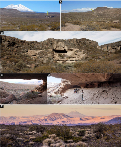
The Cueva Huenul 1 site is a cave with a habitable area of 620 m³, formed by the erosion of ignimbrites of the Tilhué Formation beneath an overlying basalt layer of the El Puente Formation, which have not eroded and now form the ceiling of the cave. Excavations within this cave have produced over 5500  lithic artifacts, principally flaked stone objects, and 8800 bone specimens, mostly Guanaco, Lama guanicoe. The site also has a long, and well-defined dating sequence, spanning 12 000 years, with a number of discrete phases of activity identified. The microenvironment within the cave appears to have remained stable and dry over this period, allowing for the excellent preservation of items such as Animal dung, and plant remains. 

Cueva Huenul 1 environment and landscape. (A) emplacement of Cueva Huenul 1 (yellow arrow) in a volcanic landscape within the Monte desert. (B) to( D) Views of the cave’s geology and topography. (E) View from Cueva Huenul 1 of the volcanic landscape of northwestern Patagonia. Guadalupe Romero Villanueva in Villanueva et al. (2024).

Notably, the Cueva Huenul 1 site has yielded a remarkable quantity of art-related materials, including  perforated  shell  beads, decorated Guanaco bones, and pyro- engraved  gourds. Also found inside the cave was a pit-structure containing a large number of twigs from the desert shrub Senna  aphylla, which have been stained with red ochre. A large amount of pigments, of various colours and in varying states of preparation.

Cueva Huenul 1 site plan and special findings. (A) excavation units at ch1. (B and C) General and detailed view of pit structure filled with vegetal remains of Senna  aphylla stained with red ochre. (D) Pyro-engraved gourd. (E) Perforated shell bead. (F) decorated guanaco (Lama guanicoe) bone. (G) Pigments. each image has an individual metric scale. Guadalupe Romero Villanueva and Ramiro Barberena in Villanueva et al. (2024).

The site has a panoramic view of the surrounding landscape, although it is not visible from any other known archaeological site in the region, nor can any such site be seen from the cave. Other sites in the region include a series of smaller caves and rockshelters, most of which only appear to have been used within the last 2000 years. Some of these, such as El Ciénego and Paso de las Tropas, also have rock art, although it is less diverse in technical style and less formalised than the art at Cueva Huenul 1. The Cueva Yagui site, to the north of Cueva Huenul 1, also records a long timeline, in this case about 8 500 years, and appears to have been more intensely occupied, on the basis of stone tools, abundant ceramics, and faunal remains, with this occupation being particularly intense over the past 2000 years. Both the stratigraphic sequences and the styles of rock art suggest that Cueva Huenul 1, Cueva Yagui, and other sites appear to have been linked.

Cueva Huenul 1 hosts one of the most impressive collections of rock art in northwestern Patagonia, with central portion of the cave’s internal wall and part of the ceiling covered by 895 discrete pieces of rock art, which have been grouped into 466 identifiable motifs. Most of these motifs are geometric shapes rather than pictures, with strokes, dots, circles, and lines being common, and parallel lines, reticulates, polygons, and cruciforms also present, as well as some Human silhouettes and a face, and silhouettes of Guanaco and Choique, Rhea pennata, and some representations of dynamic group  activities. A range of colours are used in the cave art, although a haematite-derived red is the most common, along with different hues of white, yellow, and black.

Examples of the rock art of Cueva Huenul 1. Each tracing has a 10cm scale bar. Guadalupe Romero Villanueva in Villanueva et al. (2024).

A large number of motifs are superimposed over earlier artworks, and there appear to be three distinct degrees of weathering, as well as distinct artistic phases. The majority of the art is presumed to be of Late Holocene origin, based upon similarities to styles of art used at other localities. However, the long history of occupation at the site combined with presence of a clear artistic sequence, raises the possibility that some art at the site may be much older.

Four artworks at the Cueva Huenul 1 site were chosen to be dated. These were all classified as 'comb-shapes' based upon a shared basic morphology of a perpendicular horizontal line with several parallel vertical lines extending downwards from it. Within this simple pattern, however, the comb motifs can be divided into simple and complex forms. Three of the motifs examined, UT3- M48, UT5- S4- M7, and UT3- M37, were of the simple type, while the fourth, UT5-S2-M19, was of the complex form. All of the comb motifs are executed in a reddish black pigment. Most are isolated from other artworks, although one (UT5-S2-M19) is part of a complex series of superimposed images from different periods. 

Dated rock art paintings from Cueva Huenul 1. (A) Motif Ut3- M37. (B) Motif Ut3- M48. (C) Motif Ut5- S4- M7. Guadalupe Romero Villanueva in Villanueva et al. (2024).

By careful examination of the motifs, Villanueva et al. were able to establish that there was no potentially contaminating organic matter  either  on,  within,  or  below  the  paint  layer. Three layers were found to be present, the bedrock, the pigment layer, and an overlying layer of translucent particles forming a patina. The pigment layer was identified spectrographically as amorphous carbon; this was found not to contain any significant amount of phosphates, making it unlikely it was derived from carbonized bone.

Dated rock art motif UT5- S2- M19 from Cueva Huenul 1. (A) Original photograph and digital enhancement with DStretch of the complete rock art panel. (B) Original photograph and digital enhancement with DStretch of the dated black comb-shaped motif. (C) digital tracing of the complete rock art panel showing the dated black comb-shaped motif underlaying a series of superimpositions. Guadalupe Romero Villanueva in Villanueva et al. (2024).

Further examination of the samples by Scanning Electron Microscopy and Energy Dispersive X-Ray Analysis demonstrated the presence of plant cells within the pigment layer of all four examined motifs, as well as a composition consistent with a carbonaceous material mixed into an aluminosilicate matrix (i.e. a mixture of charcoal and clay), with the overlying layer of material rich in calcium and sulphur, probably indicating some form of salt. The precise origin of the wood used to make the charcoal was impossible to determine, although it is likely to have been one of the woody shrubs known to have been growing in the region in the Middle Holocene, such as Prosopis spp., Larrea sp., or Schinus sp..

Cross section microphotography of sample CH1-AMS1 embedded in resin showing three differentiated layers. From the bottom, the layers which can be distinguished are; the bedrock support, the black pictorial layer, and a thin layer of patina or varnish. Marcela Sepúlveda and Guadalupe Romero Villanueva in Villanueva et al. (2024).

Based upon this, Villanueva et al. conclude that the black pigment was formed by the incomplete burning of Plant matter, something which should lead a carbon¹⁴ signature. Since there are no long-lived trees in the region, material from which can give misleading date information, the charcoal can be assumed to have come from a short-lived woody C₃ shrub and/or a Cactus (which have their own Crassulacean acid metabolism resulting in a distinctive carbon isotope signature). It was possible to recover sufficient carbon from three of the motifs to be confident that the isotope signature recovered was accurate, while one sample, taken from motif UT5-S2-M19, yielded a much lower amount of carbon, raising concerns that contamination from later sources (this is the motif which is partially overlain by later artworks), leading to this data being excluded from the remainder of the study. The remaining three motifs were found to be between 7728 and 7565 years old (UT3- M48), between 6271 and 6239 years old (UT5- S4- M7), and between 5643 and 5629 years old (UT3- M37).

As well as the dates obtained for the rock art motifs, Villanueva et al. obtained 16 dates from archaeological remains at the site, in order to build up a stratigraphic sequence. This led them to conclude that there had been four stages of occupation at the site, over a period of about 18 000 years. 

The first phase is calculated to have lasted approximately 4683 years, from about 17 407 to about 12 934 years before the present. During this phase the cave was occupied by Giant Sloths, with no signs of Human activity. 

The second phase is calculated to have lasted approximately 1620 years, from about 11 721 to about 10 162 years before the present, and shows evidence of the first Human activity in the area, including Guanaco bones with cut marks, hearths with charcoal, and a grass bedding structure. 

There is then a significant hiatus in activity, with the third phase starting about 8171 years ago and lasting for approximately 3246 years, till about 5074 years before the present. This phase includes the emergence of rock art at the site, with all three dates obtained for the comb motifs falling within this interval, as well as the ochre covered Plant remains. Assuming that the average Human generation time was about 25 years, this would suggest a cultural tradition using similar symbolism which lasted for about 130 generations. 

The final phase of activity at the cave includes much more intensive activity, includuing the majority of the rock art, as well as cultural similarities to other sites in the region, and spans about 1500 years in the Late Holocene.

Climatically, the area had a sharper east-west variation in moisture during the Late Pleistocene and Early Holocene, until about 10 000 years ago, with the western Andes being wetter than today, while the eastern Andes were drier. The region to the east of the Andes, inclding the Cueva Huenul 1 site, was significantly more arid than today between about 10 400 and 9 400 years ago. From about 10 000 years ago onwards both the Andes and Eastern Patagonia became extremely arid.

The area reached peak aridity in the Middle Holocene, with widespread deserts and only patchy, fragmented areas of habitable land, which could have acted as stepping stones for the first Humans entering the environment. Large areas would have either too dry for occupation, or too unstable to be entered on more than a temporary basis. Nevertheless, Humans did enter the landscape during this time, probably relocating frequently, and needing to maintain social contact over large distances, while at the same time coming up with innovative technologies for subsistence.

By assembling a comprehensive database of radiocarbon dates for Human activity across the South American Arid Diagonal region, Villanueva et al. conclude that during the period 14 000 to 10 400 years before present the first Human population appeared and rapidly grew, expanding to occupy new niches. From about 10 800 to 7000 years ago a period of cultural stasis appeared, combined with a slowly declining population. The oldest rock art at Cueva Huenul 1 is slightly less that 8000 years old, coinciding with the later part of this period of apparent cultural stasis. The population is also thought to have remained fairly static or shrank across South America between about 9000 and about 5500 years ago. 

This suggests that during the Middle Holocene northwestern Patagonia was probably home to a small and scattered population of highly mobile hunter-gatherers, coping with an extremely arid climate with occasional wetter spells. This population was static or shrinking slightly, widely scattered, and having to cope with frequent but unpredictable extreme weather conditions.

The dating of the comb motifs in the rock art of Cueva Huenul 1 gives a date for the origins of rock art in northwestern Patagonia. The repeated nature of these motifs makes it unlikely that these marks were random, with similar marks being repeated several times over a period of about 3000 years, suggesting it was linked to a system for passing information between generations.

Transmission of knowledge can become linked to particular sites, which eventually become key locations for a culture, where people meet to re-enforce cultural identities and maintain extended social networks. Villanueva et al.  suggest that Cueva Huenul 1 first became such a culturally important site during the Late Pleistocene, being used regularly over a period of about 1400 years across the End Pleistocene and Early Holocene. Visits to the site continued into the Middle Holocene, though the behaviour of the visitors changed, with the appearance of activities such as marking the walls. During this phase, there is little sign of non-ritual activities, such as food-processing or tool-making. Villanueva et al. suggest that the transition of the space to a ritual centre where these profane activities were not carried out probably implies that the site was not, as previously assumed, abandoned for long periods during the Middle Holocene, but rather underwent a change of purpose connected to its new, sacred status. 

Villanueva et al. suggest the emergence of sites such as Cueva Huenul 1 which helped hold widely scattered cultures together would have been key to Human survival in the arid landscape of northwestern Patagonia. The emergence or rock art was probably a way of re-enforcing knowledge transfer across generations, building upon an earlier oral tradition. 

The population of many areas in South America apparently struggled to cope with conditions in the Middle Holocene, as increasing aridity fragmented the available liveable spaces, leading to a slowly dwindling population. The first rock art at Cueva Huenul 1 coincides with this period, possibly aiding social cohesion and helping  people to survive a particularly harsh period, before populations began to recover between 7000 and 5000 years ago. 

The dating of the rock art at Cueva Huenul 1 gives an insight into the context in which such art first appeared in Patagonia. Here, a style of art appears around 8000 years ago and persists for over 3000 years. This happened at a time when the climate was much drier and less predictable than today, at a time when Human populations were at best maintaining stasis, and were probably suffering frequent crashes. It this marginal, sparsely populated environment the rock art apparently helped to preserve collective knowledge across multiple generations. 

See also...

Monday, 31 July 2023

Cattle in the rock art of Wadi Bajdha, Saudi Arabia.

Saudi Arabia covers an area of about 2 million km² with rock art known from every area of the country. A comprehensive survey of the rock art of Saudi Arabia begun in 1981 took over 15 years to complete, and recorded over 2000 sites with pre-Arabic and early Arabic inscriptions, as well as thousands of petroglyphs (images made by inscribing into a rock surface).

In a paper published in the Journal of Historical Archaeology and Anthropological Sciences on 3 July 2023, Majeed Khan and Faisal Al-Jabrin of the Antiquities Sector of the Saudi Ministry of Culture, describe a newly discovered rock art site at Wadi Bajdha in the Tabuk Region of Saudi Arabia, and discuss the implications of the images discovered there.

The art is located in a deep valley surrounded by mountains to the northwest of the city of Tabuk, where water collected during the rainy season. The site has historically been visited seasonally by Bedouin herders, and may have, at times, hosted permanent settlements.

The rock art is located on a vertical rock face on the side of a hill, which appears to contain images from different periods. The oldest figures on this panel appear to be a group of Cattle with short horns and flat humps. These Cows appear to be different from both the long-horned Oxen depicted at the Neolithic sites of Jubbah and Shuwaymis, and the high-humped Indian Zebu-like Cattle depicted in the Najran area of southern Saudi Arabia. Khan and Al-Jabrin suggest that this art represents the second phase of Cattle domestication in Saudi Arabia, following the Neolithic long-horned Oxen phase.

The rock art gallery at Wadi Bajdha in the Tabuk Region, in north of Saudi Arabia. Khan & Al-Jabrin (2023).

The rock art of Saudi Arabia is highly diverse, and appears to have been produced in a range of contexts with different purposes and meanings. Neolithic images appear to show Oxen as both Animals hunted as prey, and as sacred or possibly Divine Animals. Chalcolithic images have been interpreted to show Oxen as mythical creatures, deities, and sacrificial Animals. With this in mind, Khan and Al-Jabrin are careful to compare the Wadi Bajdha rock art to rock art from other locations, before drawing any conclusions about its meaning.

An open air temple, where Cows are depicted with idoliform images possibly deities or gods, located in Wadi Damm northwest of Tabuk. Believed to be evidence of Cow worship in Arabia. Khan & Al-Jabrin (2023).

Archaeological evidence and rock art depictions both suggest that Wild Cattle, Bos primigenius, were present in Arabia as both wild and domestic Animals during the Neolithic. At sites such as Shuwaymis, Jubbah, Hanakiya, large numbers of Oxen are depicted, with flat backs and exaggerated horns. These resemble European Wild Cattle, Bos primigenius, an Animal not known after the Neolithic climate shift, which occurred about 7900 years ago in northern Arabia, and led to a shift from a cool, humid climate to a hot, arid one.

Long-horned flat-back Oxen from the  Neolithic Shuwaymis site in the north of Saudi Arabia. Evidence of the presence of Wild Oxen in Arabia. Khan & Al-Jabrin (2023).

Petroglyphs of Cattle in Saudi Arabia represent at least three separate climatic phases, which each phase associated with images of different sizes, styles, and execution techniques, which has enabled the development of a chronology for such art, which links Animal type to climate shifts.

Earliest known image of Long-horned Cow, Bos primigenius, from Saudi Arabia dated to about 9000 BC. This image located at the Neolithic Jubbah, site in the north of the country. Superimposed on the Cow is a Camel figure of much later period. There is a difference of several thousand years between the two Animals; representing two climatic phases; cool and humid (Cow) and hot and dry conditions (Camel). Khan & Al-Jabrin (2023).

The style of the rock petroglyphs at Wadi Bajdha suggests that the art dates from the Chalcolithic Period, about 3500 BC. At this time people in the area had domesticated Cows and Goats, and engaged in small-scale hunting along with the hunting of Ibex. Camels did not appear in Arabia until the Bronze Age (along with Date Palms), and are absent from the Wadi Bajdha art. 

A pregnant Cow. A small baby can be seen inside the mother Cow, a firm indication of a domesticated Cow. Domesticated small horned and flat back Cattle are found on several sites in northern and southern Arabia representing the middle phase of Chalcolithic domesticated Cows, around 3500 BC. Khan & Al-Jabrin (2023).

The left corner of the Wadi Bajdha panel depicts a number of large, Chalcolithic-style Cows, as well as several Ibex, and some Horse riders with lances. These appear to have been made by artists from different periods, who took care not to overlap the art, as well as some tribal symbols. Battles between riders armed with lances was common among Bedouin tribes into the recent past.

The third phase in the art gallery represented by Camel and pre-Arabic Thamudic inscriptions in addition to Horse riders with long lances in fighting attitude drawn by the people representing the last phase of rock art in this gallery. Khan & Al-Jabrin (2023).

The Wadi Bajdha art shows apparently domesticated Cattle, including a pregnant female with a baby inside, but no images of Camels, suggesting that this art is Chalcolithic in origin. The site is likely to have has good living conditions during this interval, supporting a permanent or semi-permanent population, who presumably left as the climate continued to get hotter and drier. Many other rock art sites in Saudi Arabia show similar combinations of Human and Animal figures, and appear to have been abandoned after short periods of occupation. This suggests that the population of Saudi Arabia has been largely nomadic for much of its history, inhabited by groups who moved regularly depending on the availability of water. 

See also...

Follow Sciency Thoughts on Facebook.

Follow Sciency Thoughts on Twitter.


Saturday, 27 May 2023

Plans for Early Neolithic megastructures discovered in the northern Arabian desert.

Humans have been making physical representations of the world around them for at least 40 000 years, principally by creating images and carvings of important things within that world. Maps and plans provide two-dimensional representations of three-dimensional spaces on a reduced scale, to help their users understand and navigate those spaces, and are considered to be a special type of physical representation, resulting from a significant cognitive jump in our understanding of the world. Humans have been modifying their world in a way that implies a degree of advance planning for many thousands of years, but the earliest known plans and maps currently date from the early literate societies of Mesopotamia and Egypt, and even from this era such maps and plans are very rare. How earlier Neolithic communities planned buildings and other communal spaces is unclear. 

In a paper published in the journal PLoS One on 17 May 2023, Rémy Crassard of the Laboratoire Archéorient at Université Lyon 2, Wael Abu-Azizeh, also of the Laboratoire Archéorient at Université Lyon 2, and of the Institut Français du Proche-Orient, Olivier Barge, again of the Laboratoire Archéorientt at Université Lyon, Jacques Élie Brochier of the Maison méditerranéenne des sciences de l'homme at Aix Marseille Université, Frank Preusser of the Institute of Earth and Environmental Sciences at the University of Freiburg, Hamida Seba and Abd Errahmane Kiouche of the Laboratoire d'InfoRmatique en Image et Systèmes d'information at the Université de Lyon, Emmanuelle Régagnon and JuanAntonio Sánchez Priego, again of the Laboratoire Archéorient at Université Lyon 2, Thamer Almalki of the Heritage Commission at the Ministry of Culture of Saudi Arabia, and Mohammad Tarawneh of the Petra College for Tourism andArchaeology at Al-Hussein Bin Talal University, describe the discovery of realistic plans for desert kites, Neolithic megastructures believed to have been used as traps for wild Animals, from southeast Jordan and northern Saudi Arabia.

Other representations of kite structures have been found before, but these are somewhat rough in execution, and appear to be generic images, rather than depicting specific kites, whereas the images reported by Crassard et al. appear to be extremely detailed and accurate depictions of specific kites close to the site of the representations. These plans are presumed to have been made by the same people who made and used the kites, as the kites themselves are to large to be directly observed from the ground, and are generally understood by modern observers only once seen from the air. This reveals the degree of planning that went into these structures, and the grasp of the landscape possessed by the people who made it. The plans may have been used in developing hunting strategies involving the traps, as well as in the construction of the traps themselves, and reveal the way in which their makers were able to perceive space and plan communal activities in advance.

Desert kite are megalithic structures comprising two or walls forming a driving line which can range in size from hundreds of metres to several kilometres across, leading to an enclosure with a typical area of about 10 000 m², surrounded by up to 20 pit traps, which can be as much as 4 m deep, into which Animals were driven by the hunters. These are the earliest Human-built large scale structures known, with the oldest examples dating to about 9000 years ago in the pre-pottery Neolithic of Jordan. 

Distribution and characterization of desert kites. (A) Desert kite plan from Kazakhstan (Ustyurt Plateau). (B) Desert kite plan from Armenia (Mount Aragats). (C) Desert kite plan from Jordan (Harrat al-Shaam). (D) Desert kite plan from Saudi Arabia (Khaybar). (E) Distribution area of desert kites from western Arabia to Uzbekistan. (F) Oblique aerial picture of a desert kite in Jordan (Harrat al-Shaam, photo OB, Globalkites Project). (G) Oblique aerial picture of a desert kite in Saudi Arabia (Khaybar). (H), (I), (J) Desert kite pit-traps during and after excavation (of half the pit) in the Harrat al-Shaam region of Jordan. Crassard et al. (2023).

Hunting techniques of ancient Humans (and Hominins) have been studied by archaeologists for a long time, but most of this effort has been directed at weapons technology, with structures such as desert kites only receiving attention in the past few years. The first known desert kites were observed during aerial surveys in the 1920s, but the advent of satellite photography has revealed how widespread these structures are, with examples known from Arabia through the Middle East and Caucasus Mountains and Uzbekistan and into Central Asia, and west across the Sahara as far as Mali and Mauritania. These are believed to have been used in large-scale hunting enterprises targeting whole herds, carried out in desert areas far from permanent settlements. Their appearance, along with the appearance of the first farms in the Near East, indicates the emergence of a highly innovative approach to obtaining resources, in this case meat and other Animal resources, which goes far beyond meeting simple subsistence needs. This marks the beginning of a process by which Humans came to take control of landscapes across the planet.

Kite JKSH 04 (JD1091). Top plan and different views of the excavation of pit trap St.02. Crassard et al. (2023).

The Globalkites Project website now records over 6000 desert kites, across the Sahara, Middle East, Caucasia, and Central Asia. These are most numerous on the lava fields of s Harrat alShaam in southern Syria, eastern Jordan and northern Saudi Arabia, where in places they reach one kite per square kilometre. Investigation of this area led to the discovery of two rock engravings, which appear to show nearby desert kites depicted to scale. These are on the Jibal al-Khashabiyeh plateau at the eastern edge of the Al-Jafr Basin in south-eastern Jordan and the Jebel az-Zilliyat plateau at the northern edge of the Nefud Desert in northern Saudi Arabia, with the two sites being 267 km apart.

Map showing the distribution of known desert kites. Globalkites Project.

Jibal al-Khashabiyeh is a limestone plateau about 80 km to the east of the city of Al-Jafr, which reaches a maximum elevation of about 1 km above sealevel, and slopes to the east. The plateau is rich in chert, particularly on its upper elevations. There are eight kites known from this escarpment, built from slabs of white limestone and piles of chert. As well as the kites, eight ancient campsites have been found, apparently one per kite, of which three have been excavated by archaeologists, including one, F15, which had previously been targeted by looters, and which yielded the first stone engraving representing a kite.
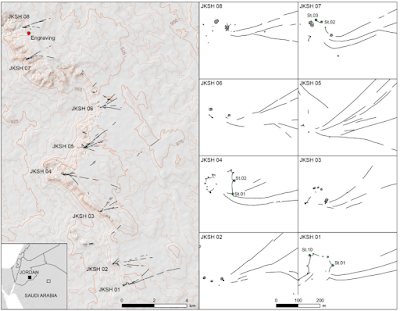
Location of fieldwork in Jordan. Location of the eight desert kites in the Jibal al-Khashabiyeh region in south-eastern Jordan (left), and detailed plans of these kites (right), with mentions (St.n) of excavated pit-traps. The red dot in the general map (left) shows the location of the engraving, found at the JKSH F15 site. The green dots in the kite plans indicate the excavated pit-traps and their numbering. Crassard et al. (2023).

Jebel az-Zilliyat lies 260 km to the east in Al-Jawf Province, Saudi Arabia, where it forms part of a complex landscape of grabens and faults. Two kites are present on top of the plateau, AB135/AB136 and AB547/AB549, separated by about 3.5 km. During a foot survey of a drainage feature on the plateau, a large engraving apparently depicting both kite enclosures, drawn to scale, was discovered. 

Location of the fieldwork in Saudi Arabia. Location of the four desert kites in the Jebel Az-Zilliyat region in northern Saudi Arabia (top), and detailed plans (bottom) of the two pairs of kites. The red dot in the general map (top) shows the location of the engraving, in the bed of Wadi az-Zilliyat. The green dots in the kite plans indicate the excavated pit-traps and their numbering. Crassard et al. (2023).

The F15 site on Jibal al-Khashabiyeh is a pre-pottery Neolithic site which has been disturbed bu recent looting. Despite this, numerous carved stones are still present, albeit for the most part disturbed and not in their original positions. Many of these conform to the 'ciger-shaped stone' form associated with the pre-pottery Mureybetian Culture, which was found across the Near East from about 10 200 to about 8000 years ago. One notable such monolith, found in June 2015, and measuring roughly 80 cm long, 32 cm wide, and 18 cm deep, and weighing 92 kg, shows a well preserved engraving of a kite.

Discovery of the engraved stone in Jibal al-Khashabiyeh, Jordan. (A) Orthomosaic view of JKSH F15 site where the kite’s engraving was found on a monolith (in red is the location of the rescue excavation in the looter’s spoil). (B) Photograph of the engraved stone at the time of discovery at the JKSH F15 site (the monolith was found lying down and was set vertically for the photograph). (C) Photogrammetric 3D model of the engraved monolith showing the different faces, including the engraved upper face (top), while the hill-shaded model (bottom) shows the interpretative drawing of the engraved plan on the stone. (D) Drawing of a projected view of the kite representation engraved on the monolith from the JKSH F15 site. Crassard et al. (2023).

The edges of the monolith appear to have been shaped with a large hammerstone, while the engraved depiction of the kite shows a mixture of carving techniques. Fine incisions have been used to delineate the borders of the kite, while a pecking tool has been used to etch out the interior area. The limestone of the monolith is soft and chalky, and could have easily been worked with a burin, scraper, or similar chert tool. The surface of the plateau is covered with high-quality chert, much of which shows signs of having been modified by Human activity. The entire interior of the kite has been carved out to a depth of 0.5-1.0 cm, producing a smooth, low relief model.

Detailed photographs of the engraved stone surface from Jibal al-Khashabiyeh, Jordan. The detailed views emphasize the various techniques used for the kite engraving found at the JKSH F15 site. The detailed photographs on the left are lettered, indicating their position on the engraved monolith, as shown on the right. Crassard et al. (2023).

The carving can clearly be seen to be a kite structure, with the driving lines depicted by two converging carved lines about 40 cm in length, leading to a star-shaped central enclosure about 26 cm in diameter, with a circumference marked bu eight cup-shaped depressions at the tips of the star-points, ranging from 2.5 to 6 cm in diameter, which represent the pit traps of the kite. Part of the right side of the enclosure is missing, either having been lost to weathering or never completed, and, given the overall symmetry of the shape, it appears likely that a ninth cup-shaped depression would have been present in this section. The driving lines are almost parallel, forming a long, straight, corridor-shaped funnel, with a sharp 90° turn and sharp convergence at the entrance to the central enclosure. This plan is common in kites seen in southeastern Jordan, and more rarely in northern Saudi Arabia, but is not known from other kite-assemblages in the region. 

Just before the turn in the driving line, a series of five chevrons can be seen running across the width of the corridor, which Crassard et al. suggest may be of symbolic significance, or represents a structure made from lighter materials which have not been preserved, such as a beater-driven hunting spot or a net, or (most likely) represent a break in the topography. 

The Jebel az-Zilliyat representation is significantly larger, and was discovered during a survey of rock are in Wadi az-Zilliyat, which cuts across Jebel az-Zilliyat, in March 2015. Two representations of kites are engraved upon a flat surface on the side of a sandstone boulder, which had fallen to the floor of the wadi from an overhanging cliff. The eastern of this pair of posts is readable, but the one on the western side is heavily eroded. The plan here was constructed entirely by pecking at the rock with some sort of hand tool. As at Jibal al-Khashabiyeh, abundant chert is available at the site, from which a suitable tool could have been made. The eastern kite has two short, widely spaced, converging driving lines, measuring 80 cm and 85 cm, respectively. These lead to star-shaped enclosed area 50-60 m across, with a cup-shaped pit 3-5.5 cm deep at the tip of each of its six points. The southernmost two of these cups are around a corner on another face of the rock. The western kite is less clearly defined, with much of the image apparently lost to rock exfoliation, It has two converging driving lines, 85 cm and 60 cm in length, and a star-shaped enclosure 40-45 cm across with at least four cup-shaped depressions. The southern part of this enclosure is missing. It is unclear if the engraving was made on the rock before or after it split from the rock face.

Location of the engraved rock in Wadi az-Zilliyat, Saudi Arabia. (A) General view of Wadi az-Zilliyat, from the northeast, the location of the engraved boulder is shown by the white circle. (B) General view of the collapsed boulders from the southeast, the white circle indicates the position of the engraving. (C) General view of the engraved rock (white circle) location among the collapsed boulders, from the east. (D) The engraved boulder as discovered during rock art survey, view from the north. Crassard et al. (2023).

It was not possible to date the engravings at either site, although a radiocarbon date of 8016 years before the present (6930 BC) was obtained from a piece of charcoal at the F15 campsite on Jibal al-Khashabiyeh. This campsite had apparently been disturbed by looters, making the context slightly difficult to interpret, but the site appears never to have been re-used after its initial occupation, so it is likely that the date will be close to the creation of the engraving and nearby kites.

The engraved boulder from Jebel az-Zilliyat, Saudi Arabia. (A) Drawing of a projected view of the kites’ representation showing picking tool traces, engraved and weathered zones. (B) Drawing of a projected view of the kites’ representation showing legible and unclear engravings, with a colored restitution of the microtopography of the boulder surface. Crassard et al. (2023).

Crassard et al. next set out to compare the designs of the depicted kites to actual kites in the region. All of the eight kites on Jibal al-Khashabiyeh are similar to the design depicted in the engraving, with four having a sharp bend at the point where the converging driving lines meet the enclosure, including the two kites closest to the engraving, JKSH 07 and JKSH 08. In both of these kites the northern driving line remains straight while the southern line curves sharply, to create the bend in the corridor that leads to the enclosure, which is the layout depicted in the engraving. All of the kites on Jibal al-Khashabiyeh have been heavily eroded by water drainage since their creation, so that the star-shaped enclosures can only be identified in three structures; at JKSH 01 eight pit-traps are preserved, and it appears likely that there were originally nine (from the shape of the enclosure and regular spacing of the pits). Kite JKSH 04 also has eight pits preserved, but in this case it is calculated that there were originally another three. At JKSH 07 only three pits remain, but it is thought likely that there were once another six. All three of these kites were excavated, revealing that the pits were stone-faced hollows 143-176 cm deep. One of the pits at JKSH 01 was found to contain five pieces of charcoal, one of which yielded a radiocarbon date of approximately 7000 years.

Detailed photographs and hill-shaded surface models of the engraved stone surface from Jebel az-Zilliyat, Saudi Arabia. The detailed views emphasize the various techniques used for the kite engraving. The detailed photographs and hill-shaded surface models on the left are lettered, indicating their position on the engraved boulder, as shown on the right. A and B are showing examples from the eastern depiction of a kite, C and D from the western one. Hill-shaded surface models are used to better render the legibility of the engravings, otherwise less visible from the photographs made on site. Crassard et al. (2023).

The engraved rock at Jebel az-Zilliyat lies within a wadi, which runs between two pairs of desert kites, AB547 and AB549 to the west, and AB135 and AB136 to the east. This eastern pair are separated from one-another by 120 m, and have south-facing openings and funnel entrances which run parallel to one-another. AB135 has a large, star-shaped enclosure, typical of kites in this region, with three driving lines, the longest of which is 3379 m. The preservation of this kite is not good, with parts of the structure having been raided for stone to make later stone-aged structures, such as tombs (stone mounds, cairns) and circular structures (pastoral or dwelling enclosures), and more recently other parts having been demolished during gas and oil exploration work.

Comparison of the kite layouts depicted on the engravings with the top-view plans of neighboring desert kites in Jibal al-Khashabiyeh, Jordan and Jebel az-Zilliyat, Saudi Arabia. (A) Comparison of the kite layout depicted on the engraved monolith (left) with the top-view plans of the four better preserved kites identified in Jibal alKhashabiyeh (right). The red dotted line is the shape of the kite engraving, used for superimposition on the desert kite maps. (B) Comparison of the kite engraving found at Jebel az-Zilliyat (left) with top-view plans of the four neighboring desert kites (right). Gray zones are destroyed or reused areas, after the period of kite use. Crassard et al. (2023).

Despite these problems, a combination of aerial observation and fieldwork has allowed Crassard et al. to build up an accurate idea of the original structure of AB135. The kite has four well preserved pit traps on its northwestern side, and two more on its southern edge, at the edge of a plateau cliff. The eastern one of these is heavily damaged, making it difficult to assess its original structure. A series of further pit traps are present on the northern side, along the structure's driving lines, but these are of a different design, of courser construction, and show a different degree of desert varnish (an orange-yellow to black coating found on exposed rock surfaces in arid environments, composed of particles of clay along with oxides of iron and manganese), suggesting that these were built as add-ons to the original structure at a later date. 

Kite DAJ137 (AB135). (A) Aerial view of pit-traps L03 (archaeological excavation), L04 and L05. (B) L03 before excavation. (C) L03 after excavation. Crassard et al. (2023).

Two of the pits at AB135 were excavated; AB135-L01, which yielded some old red altered soil unsuitable for optically stimulated luminescence or radiocarbon dating, and AB135-L03, which produced five fragments of calcitic nutlets of Arnebia sp., from a layer about 10 cm above the bottom of the pit. These fragments yielded a radiocarbon date of approximately 6760 years before the present (about 5670 BC), while a sample of sediment from the bottom of the pit yielded an optically stimulated luminescence date of approximately 7690 years before the present (about 5675 BC); this theoretically should be a date after the trap fell into disuse and began to fill with sediment, providing a minimum age for the structure. 

Kite DAJ140 (AB549). Aerial oblique view of the enclosure. Crassard et al. (2023).

Kite AB136 is better preserved than its neighbour, consisting of two driving lines, 156 m and 54 m in length, plus a 4200 m² enclosure with six pits. None of these pits contained any significant amount of sediment, preventing any useful archaeological excavation of the site.

Kite DAJ140 (AB549). Aerial view of pit-traps L01 (archaeological excavation, on the left) and L02 (on the right). Crassard et al. (2023).

The pair of kites on the western side of the wadi, AB547 and AB549, appear to have been made using the same construction techniques as the kites on the west, but are much better preserved. These appear to have shared a single pair of driving lines, these being 1549 m and 2623 m in length, while the two traps have enclosures of 5500 m² and 6300 m², respectively, and both have six pit traps. None of the pits of AB547 was considered suitable for excavation, although careful examination of the structure in the field appeared to confirm that it was structurally related to AB549, with the two structures apparently being used together. One of the pits of Kite AB549 was excavated, having 60 cm of accumulated sediment above its base, Here eleven small fragments of Arnebia sp. nutlet were found, one of which yielded a radiocarbon date of 3300 years before the present, or about 1570 BC, while sediment from near the base of the pit produced two optically stimulated luminescence dates of approximately 8040 and 7480 years before the present (about 6025 and 5465 BC). Crassard et al. note that this difference in the dates obtained using the radiocarbon and optically stimulated luminescence dating methods underlines the need to use more than one dating method where possible. In this instance they believe that the anomalous date from the Arnebia sp. nutlets ewas due to the high mobility of such small plant remains, and that the sediment dates provide a minimum age for the trap falling into disuse.

Composite ortho-mosaic illustrating the fully deployed projection view of the engraved monolith found at JKSH F15 site. An outlined drawing shows the interpretation of the whole engraving. Crassard et al. (2023).

Crassard et al. tested the similarity of the kite engravings to kite structures in the region using a computer-based graph modelling based upon satellite images of the kites. Graphs are mathematical structures, with vertices (fixed points) linked by edges (lines), making them highly suitable for comparing similar structures, and are commonly used in studies of desert kites.

Hypothetical interpretation of the chevron pattern engraved on the kite depiction on the monolith from JKSH F15 site, Jordan as a topographic symbol. The detail of the chevron pattern (bottom) is compared to the slope break seen in the topography (here at kite JKSH 04, top). Crassard et al. (2023).

The model used by Crassard et al. compared the kite images to 69 actual kites in the region, concluding that the kites showed between 26.83% and 81.43% similarity to the Jebel az-Zilliyat engraving and between 11.46% and 75.90% to the Jibal al-Khashabiyeh engraving, where 100% would represent an exact match. This suggested that the kite most similar to the Jebel az-Zilliyat engraving is AB135, which is only 2.3 km from the engraving, while the most similar kite to the Jibal al-Khashabiyeh engraving is JKSH 01, which is 16.3 km from the engraving. However, JKSH 01 is only a 75.9% match for the Jibal al-Khashabiyeh engraving, note notably greater than the kite JKSH 07, which is 73.52% similar to the engraving, and only 1.4 km away.

Reconstruction of the layout of the enclosures at the three excavated kites in Jibal al-Khashabiyeh, Jordan. The reconstruction is based on the structural remains preserved in the field to estimate missing pit-traps around the enclosure’s perimeter. Crassard et al. (2023).

The kite engravings show clear similarities to the actual kite structures, something which can be detected when both qualitative and quantitative approaches are used, and appear most likely to be direct representations of the kite structures closest to them. These carvings are realistic, and surprisingly accurate to scale, given the gigantic size of the kite structures and the difficulty in comprehending their layout without access to modern imaging methods. The engravings appear to be accurate depictions of these large structures intended to help their builders/users develop a mental map of the site.

The Jebel az-Zilliyat eastern engraving shows a very clear similarity to the adjacent AB135 kite, which includes the location of two southern pits on the edge of the escarpment, which in the engraving are represented by two cups on a separate planar surface, giving a three dimensional aspect to the representation. This Jebel az-Zilliyat engraving depicts a pair of kites rather than a single structure, and AB135 is part of a pair of kites, one of two pairs of kites which are close to this engraving. The engravings are reasonably accurate at a scale of 1:175, with compass directions on the immobile boulder matching those of the actual kites. 

The Jibal al-Khashabiyeh engraving also shows strong similarities to nearby kites, with the engraving having a similar shape and number of pit traps to these kites, clearly visible when the images are super-imposed, and supported by computer modeled graph plotting of the structures. Notably, the proportions of the corridor leading to the enclosure on the engraving are a very close match for kites JHSH 01 and JKSH 04. This model has a scale of 1:425, with the size of the pits considerably exaggerated in the model compared to the actual kites, which is a reasonable approach, given that they would have been barely perceptible at true scale. Seen in this way. the larger pits still act as useful representations of the place to which Animals should be herded.

This is the first known example of an accurate depiction of a Neolithic structure made by the people who constructed it, and therefore the oldest example of such a plan in Human history. Some older images, from the Upper Palaeolithic of Europe, have been interpreted as schematic maps of the local environment; but these cannot be said to depict a scaled model of the landscape.The oldest European maps are Bronze and Iron Age representations of agricultural land divisions, showing s field features, enclosures, and dwelling areas, as well as road networks, although it is unclear if these relate to the areas where they were found. some more distant environment, or even imaginary landscapes.

The beginning of the Neolithic coincides with the onset of the Holocene in the Near East, and is accompanied by the the building of large, often megalithic, structures, and a subsequent change in social structures which included the domestication of Animals, the appearance of settled communities, the emergence of farming, the development of social hierarchies, and the beginnings of long-distance trade. Despite this, depictions of the spaces in which all these activities took place are rare. A mural from the city of Çatalhőyűk in Anatolia, dated to about 6600 BC, may be a form of map, showing a village and a volcano, possibly a reference of an eruption on Mount Hasan Dağ. A scale model of a reed boat, from Kuwait has been dated to about 5000 BC, while model houses are also known from the Kodjadermen-Gumelniţa-Karanovo culture of the eastern Balkans, dating from about 4500 BC. However, none of these can be considered to be true plans in the way that the kite depictions appear to be. The oldest representations considered to be true plans until now have been from second and third century sites in Mesopotamia, though even these are maps of large areas which do not approach the degree of accuracy seen in the kite engravings. 

Prior depictions of the kite structures have been uncovered in Jordan, Syria, and Uzbekistan, although these are not to scale, and have not been dated accurately. While these are not plans in the sense that the new material are, typically being simple, figurative images, these do reveal information about the way in which the kites were used, for example by depicting Animals and Hunters within the kites. These images typically have much reduced driving lines, but greatly exaggerated pits, apparently to emphasize their important function. Furthermore, none of these previously observed figurative kite could be associated with a particular actual kite.

Examples of previously known kite engravings, that are not represented to scale and less realistic. (A) From cairn of Hani’ site, Syria; (B) From Khishâm-2 site, rock В 37, Syria; (C) From Wisad Pools, Jordan; (D) From Azraq Basin, Jordan; (E) From Wisad Pools, Jordan; (F) and (G) are the kite engravings described in Crassard et al.'s study, respectively from Jibal al-Khashabiyeh and Jebel az-Zilliyat, represented in this figure to be directly compared with the previously known ones. Crassard et al. (2023).

Desert kites are large structures, and building them would have required a good understanding of the topography of the region, and the ability to take into account features such as convex surfaces and breaks in slopes. Thus a plan of the a kite structure could have been used to aid the design of such a structure, as a tool for organizing hunts involving the use of a kite, for some symbolic purpose not obvious to modern observers, or any combination of these.

If the kite engravings do represent construction plans, then they would have formed part of a process that began with studying the topography of the area, and the migration patterns of Animals passing through, before formalizing the plan. It would have also required the kite-builders to have the skills to follow such a design during the construction phase. The engraved kites examined by Crassard et al. show a very accurate scale plan of the kites, but do not show all of the topological features which it would have been necessary to take into account during construction, for which reason, Crassard et al. do not believe that they served as blueprints for the construction of the kites. 

The possibility that the plans were used during the organization of hunts seems to be a much more plausible explanation. Such a model, if sufficiently accurate, could be used to plan where hunters would be placed at the outset of a hunt, and to co-ordinate subsequent movements by the hunters, even taking into account what to do in the event of Animals reacting to the hunters in different ways. Seen in this light, the plan is a visual communication device pre-dating the invention of writing, acting as an aid to communication, but probably not useful without some other interaction. Nevertheless, such a plan would be likely to facilitate the development of hunting strategies, and probably led to far smoother hunt operations than would have been possible without it. The plan involves an understanding of the design of the kite and the topography upon which it sits which was probably only available to the builders of the kite, and takes into account features hidden  by that topography, such as the pits on the cliff edge at Jebel az-Zilliyat. The chevrons on the Jibal al-Khashabiyeh  kite engraving appear to be a symbolic representation of a spatial feature, and while it is difficult to determine what that feature was, this is apparently a very early example of a cartographic practice still in use today.

The plans are not completely to scale, with the most important features, i.e. the pit traps, exaggerated in size, apparently with the intention of increasing the utility of the diagram. Thus the plans represent a compromise reached while trying to find a method of controlling information, in order to make it more possible to pass on to others. In a sense, therefore, these representations can be seen as symbolic as well as practical, with the communicative function being more important than the need for complete accuracy, despite the importance clearly placed upon making an accurate representation.

Despite this use of symbolism, Crassard et al. believe that the primary function of the engravings was utilitarian rather than symbolic purpose, either aiding in the construction or (more likely) use of the kite structures.

See also...


Follow Sciency Thoughts on Facebook.

Follow Sciency Thoughts on Twitter.