Showing posts with label Bárðarbunga Volcano. Show all posts

Saturday, 16 July 2016

Understanding how caldera-collapse drove the 2014-15 Bárdarbunga eruption in Iceland.

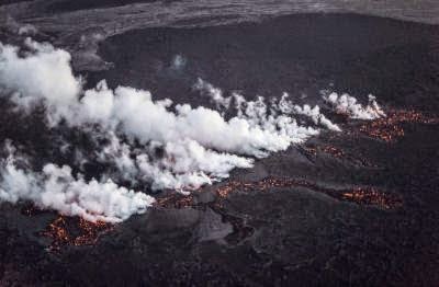
Between August 2014 and February 2015 the Bárdarbunga volcanic system in Iceland underwent the largest volcanic eruption in Iceland (or anywhere else in Europe) since the 1783–1784 eruption on Mount Laki, producing 1.4 cubic kilometers of basaltic lava, not from the main caldera, which is burried beneath the Vatnajökull Ice Cap, but rather from the Holuhruan Vent Field, which is 48 km from the caldera and is connected to it by a network of fissures. During the course of this eruption the ice sheet above the caldera subsided by 65 m, leading volcanologists to conclude that the eruption was driven by the collapse of the caldera into the underlying magma chamber, only the seventh such eruption observed sinc the advent of seismic monitoring in the early twentieth century; the earlier cadera collapse eruptions being Katmai 1912, Fernandina 1969, Tolbachik 1976, Pinatubo 1991, Miyakejima 2000, and La Reunion 2007, all of which were substantial volcanic episodes.

 Lava eruptiong from the Holuhruan Vent Field in Sepember 2014. Eggert Norddahl/Bergsveinn Norddahl/VolcanoCafe.

In a paper published in the journal Science on 15 July 2016, a team of scientists led by Magnús Gudmundsson of the Institute of Earth Sciences at the University of Iceland describe the results of a study of the 2014-15 Bárdarbunga eruption using data from seismic monitoring stations and aerial radar observations made of the caldera during the eruption.

The eruption began on 16 August 2014 with a series of small earthquakes beneath the southeastern part of the caldera, followed by the development of a new rift, which originally propagated to the southeast, reaching 7 km from the caldera within 15 hours. This rift then changed direction, migrating northeast and reachin the Holuhraun Vent Field in two weeks (the rift eventually spread to 41 km beyond the vent field). Material passing from the magma chamber through the rift reached the  Holuhraun Vent Field on 31 August 2016, leading to the onset of the visible eruptive episode.

The loss of material into the new rift system led the magma chamber to begin to deflate, placing stress on the rocks around the margin of the caldera, which were now forced to support the weight of rock and ice above the chamber. On 23 August 2016 the first of a series of small tremors on the northern part of the rim as recorded, followed by the spreading of such activity around the rim over the next few days. This in turn was followed by substantial subsidance in the central part of the caldera, as new faults developed around the rim, enablimg a plug of material above the magma chamber to subside into the chamber. This in turn forced further magma out of the chamber and into the rift system, driving further volcanism on the Holuhraun Vent Field.

 The Bárdarbunga caldera and the lateral magma flow path to the Holuhraun eruption site. (A) Aerial view of the ice-filled Bárdarbunga caldera on 24 October 2014, view from the north. (B) The effusive eruption in Holuhraun, about 40 km to the northeast of the caldera. (C) A schematic cross section through the caldera and along the lateral subterranean flow path between the magma reservoir and the surface. Gudmundsson et al. (2016).

See also...

http://sciencythoughts.blogspot.co.uk/2015/10/glacial-outburst-flood-from-grimsvotns.htmlGlacial outburst flood from Grímsvötn's Ice Lake                                                              On 27 September 2015 volcanologists from the Icelandic Meteorological Office noticed a drop in the level of ice above a subglacial lake in the Grímsvötn caldera (a lake beneath the Vatnajökull ice-cap kept liquid by heat rising from the magma chamber...
http://sciencythoughts.blogspot.co.uk/2015/10/sulphur-dioxide-emissions-from-2014-15.htmlSulphur Dioxide emissions from the 2014-15 Holuhraun Lava Field Eruption.                      In mid-August 2014 seismic monitoring stations in Iceland began to record small Earth-tremors beneath the Bárðarbunga Volcano, which rises through the Vatnajökull Glacier...
http://sciencythoughts.blogspot.co.uk/2014/11/magnitude-54-earthquake-beneath.htmlMagnitude 5.4 Earthquake beneath the Vatnajökull Glacier in Iceland.                         The Icelandic Met Office, which also monitors seismic activity, recorded a Magnitude 5.4 Earthquake at a depth of 4.1 KM beneath the Vatnajökull Glacier...
Follow Sciency Thoughts on Facebook.

Tuesday, 25 November 2014

Magnitude 5.4 Earthquake beneath the Vatnajökull Glacier in Iceland.

The Icelandic Met Office, which also monitors seismic activity, recorded a Magnitude 5.4 Earthquake at a depth of 4.1 KM beneath the Vatnajökull Glacier slightly after 9.00 am GMT on Monday 24 November 2014. This is roughly 4.1 m to the northeast of the Bárðarbunga Volcano, which lies beneath the Vatnajökull Glacier and which began an active cycle at the end of August 2014, with magma apparently rising beneath the volcano then migrating to the Holuhraun Lava field, to the north of the glacier. Magnitude 5.4 Earthquakes at shallow depths are potentially quite dangerous, but the remote location of this event makes it highly unlikely that there were any casualties or damage.

The approximate location of the 24 November 2014 Vatnajökull Glacier Earthquake. Google Maps.

 Seismic activity beneath volcanoes can be significant, as they are often caused by the arrival of fresh magma, which may indicate that a volcano is about to undergo an eruptive episode. Bárðarbunga last erupted in about 1862, and has undergone several periods of raised seismic activity since then, most recently in 1996 and 2010, so there is no reason to believe that this weeks events will automatically lead to an eruption from the volcano itself. Bárðarbunga began to undergo seismic activity (Earthquakes) on 19 August, and lava began to erupt from a fissure in the Holuhraun lava field, no the north of the Vatnajökull Glacier, late in the evening of Thursday 28 August, and has continued since then, with lava flows now covering over 37 square kilometres of land. 

Lava flows in the Holuhraun lava field. Arctic-Images/Corbis.

Iceland lies directly upon the Mid-Atlantic Ridge, a chain of (mostly) submerged volcanoes running the length of the Atlantic Ocean along which the ocean is splitting apart, with new material forming at the fringes of the North American and European Plates beneath the sea (or, in Iceland, above it). The Atlantic is spreading at an average rate of 25 mm per year, with new seafloor being produced along the rift volcanically, i.e. by basaltic magma erupting from below. The ridge itself takes the form of a chain of volcanic mountains running the length of the ocean, fed by the upwelling of magma beneath the diverging plates. In places this produces volcanic activity above the waves, in the Azores, on Iceland and on Jan Mayen Island.
The passage of the Mid-Atlantic Ridge beneath Iceland. NOAA National Geophysical Data Center.
See also...
The Icelandic Met Office recorded a Magnitude 5.4 Earthquake at a depth of 3.9 km beneath the Vatnajökull Glacier slightly before 7.10 am local time (which is...

Lava began to erupt from a fissure in the Holuhraun lava field, no the north of the Vatnajökull Glacier in central Iceland, late in the evening of Thursday 28 August, and has continued to do so for the next three days. The lava field lies to the northeast of  Bárðarbunga, a volcano...
The Icelandic Met Office recorded a Magnitude 5.0 Earthquake at a depth of 3 km beneath the Vatnajökull Glacier slightly before 8.15 am GMT on Thursday 28...
Follow Sciency Thoughts on Facebook.
 

Sunday, 7 September 2014

Magnitude 5.4 Earthquake beneath the Vatnajökull Glacier, Iceland.

The Icelandic Met Office recorded a Magnitude 5.4 Earthquake at a depth of 3.9 km beneath the Vatnajökull Glacier slightly before 7.10 am local time (which is GMT) on Sunday 7 September 2014. This was roughly 4 km to the southeast of the Bárðarbunga Volcano, which has been going through an active period for the last month. Magnitude 5.4 Earthquakes are potentially quite dangerous, but the remote location of this event makes it highly unlikely that there were any casualties or damage.

The approximate location of the 7 September 2014 Vatnajökull Earthquake. Google Maps.

Seismic activity beneath volcanoes can be significant, as they are often caused by the arrival of fresh magma, which may indicate that a volcano is about to undergo an eruptive episode. Bárðarbunga last erupted in about 1862, and has undergone several periods of raised seismic activity since then, most recently in 1996 and 2010, so there is no reason to believe that this weeks events will automatically lead to an eruption from the volcano itself. Bárðarbunga began to undergo seismic activity (Earthquakes) on 19 August, and lava began to erupt from a fissure in the Holuhraun lava field, no the north of the Vatnajökull Glacier, late in the evening of Thursday 28 August, and has continued since then. It is though likely that a magma intrusion has risen through fissures beneath the volcano and now migrated to the lava field.

Lava erupting in the Holuhraun lava field in September 2014. Armann Hoskuldsson/Extreme Iceland.

Iceland lies directly upon the Mid-Atlantic Ridge, a chain of (mostly) submerged volcanoes running the length of the Atlantic Ocean along which the ocean is splitting apart, with new material forming at the fringes of the North American and European Plates beneath the sea (or, in Iceland, above it). The Atlantic is spreading at an average rate of 25 mm per year, with new seafloor being produced along the rift volcanically, i.e. by basaltic magma erupting from below. The ridge itself takes the form of a chain of volcanic mountains running the length of the ocean, fed by the upwelling of magma beneath the diverging plates. In places this produces volcanic activity above the waves, in the Azores, on Iceland and on Jan Mayen Island.

The passage of the Mid-Atlantic Ridge beneath Iceland. NOAA National Geophysical Data Center.

See also...


Lava began to erupt from a fissure in the Holuhraun lava field, no the north of the Vatnajökull Glacier in central Iceland, late in the evening of Thursday 28 August, and has continued to do so for the next three days. The lava...


The Icelandic Met Office recorded a Magnitude 5.0 Earthquake at a depth of 3 km beneath the Vatnajökull...


Iceland has evacuated around 300 people from the area around the Bárðarbunga Volcano following a rise in...


Follow Sciency Thoughts on Facebook.

Thursday, 21 August 2014

Iceland evacuates area around Bárðarbunga Volcano.

Iceland has evacuated around 300 people from the area around the Bárðarbunga Volcano following a rise in seismic activity this week, with around 300 Earthquakes recorded close to the volcano since Tuesday 19 August 2014. The area where the volcano is located is remote and inhospitable, and has no permanent residents, but is popular with tourists in the summer. Reaching 2009 meters above sea level, Bárðarbunga is the second highest mountain in Iceland, although it is buried beneath the Vatnajökull Glacier, and not actually visible at all from the surface.

The approximate location of the Bárðarbunga Volcano. Google Maps.

Seismic activity beneath volcanoes can be significant, as they are often caused by the arrival of fresh magma, which may indicate that a volcano is about to undergo an eruptive episode. Bárðarbunga last erupted in about 1862, and has undergone several periods of raised seismic activity since then, most recently in 1996 and 2010, so there is no reason to believe that this weeks events will automatically lead to an eruption, and the evacuations are purely precautionary in nature.

Earthquakes around the Bárðarbunga Volcano in the 48 hours prior to 5.30 pm GMT on Thursday 21 August 2014. Icelandic Met Office.

Iceland lies directly upon the Mid-Atlantic Ridge, a chain of (mostly) submerged volcanoes running the length of the Atlantic Ocean along which the ocean is splitting apart, with new material forming at the fringes of the North American and European Plates beneath the sea (or, in Iceland, above it). The Atlantic is spreading at an average rate of 25 mm per year, with new seafloor being produced along the rift volcanically, i.e. by basaltic magma erupting from below. The ridge itself takes the form of a chain of volcanic mountains running the length of the ocean, fed by the upwelling of magma beneath the diverging plates. In places this produces volcanic activity above the waves, in the Azores, on Iceland and on Jan Mayen Island.

The passage of the Mid-Atlantic Ridge beneath Iceland. NOAA National Geophysical Data Center.

See also...


The United States Geological Survey recorded a Magnitude 4.8 Earthquake at a depth of 10.3 km roughly 8 km south of the...


The Icelandic Meteorological Office are reporting a series of steam explosions took place on Mount Kverkfjöll on the southeast of the Island on Thursday 15 August 2013. The explosions apparently occurred after increased glacier melting due to warm weather caused...


On Sunday 21 October 2012, at 1.25 am local time (which is GMT), the United States Geological Survey recorded a Magnitude 5.7 Earthquake at a depth of 9.9 km, roughly 21 km north of Siglufjordur...


Follow Sciency Thoughts on Facebook.