Geologic evidence suggests that the ambient climate of early Mars (Noachian; roughly 4.0–3.6 billion years ago) was significantly different than today, with compelling evidence for extensive fluvial channels and crater basin lakes, increased erosion rates, and enhanced crater degradation. Indeed, compared to younger craters, most Noachian-aged craters have (1) lowered or completely removed rims; (2) flat, infilled floors; and (3) walls and ejecta deposits modified by fluvial incision and backwasting. Morphometric studies have interpreted this set of characteristics to indicate degradation by a dual advective–diffusive process One such pair of processes involves diffusive rainsplash and advective runoff from rainfall occurring intermittently over tens of millions of years in a warm and wet Noachian climate. Although this model was not favored by Bob Craddock and Alan Howard, they noted that 'it is possible that solifluction generated the diffusional component (of crater degradation) while any surface runoff was the result of snowmelt.' This would favor a colder, potentially subfreezing Noachian climate with only transient warming. Some global climate modeling studies support ambient Noachian temperatures well below freezing, with cold-based glaciation occurring in the southern highlands. Thus, the nature of the ambient Noachian martian climate is currently debated.
In addition to their degraded morphology, numerous Noachian-aged craters on Mars have been identified as candidate sites of former lakes. In 2008 Caleb Fassett and James Head identified 210 open-basin lakes, craters fed by valley networks that contained outlet valleys indicative of lake filling and overflow. In 2015 Timothy Goudge, Kelsey Aureli, James Head, Caleb Fassett, and John Mustard identified an additional 205 candidate closed-basin lakes, similar to open-basin lakes but lacking outlet channels. Most open-basin lakes and some closed-basin lakes are fed by regionally integrated valley networks, suggesting that these palaeolake basins formed at a time similar to the peak of valley network activity around the Noachian–Hesperian boundary (i.e. about 3.6 billion years ago), and thus may have required sustained warm and wet climate conditions in order to form. In 2019 Francesco Salese, Monica Pondrelli, Alicia Neeseman, Gene Schmidt, and Gian Gabriele Ori identified 24 craters near the dichotomy boundary with floor elevations below -4 km that contained crater wall sapping valleys, terraces, and deltas that they interpreted to be sourced from groundwater upwelling; these also appear to have formed around the Noachian–Hesperian boundary.
In a paper published on the arXiv database at Cornell University on 1 March 2021, and in The Planetary Science Journal on 12 March 2021, Benjamin Boatwright and James Head of the Department of Earth, Environmental and Planetary Sciences at Brown University, report on the geology of a 54-km diameter Noachian-aged crater in the Southern Highlands that contains unusually well-preserved inverted fluvial channel networks and lacustrine deposits. Unlike previously described open-basin lakes and closed-basin lakes, this crater has neither inlet nor outlet channels and shows no evidence of sapping valleys or other associated landforms suggesting groundwater processes. On the basis of these unique characteristics, Boatwright and Head term this new type of crater a 'closed-source drainage basin', distinct from either fluvially breached or groundwater-fed crater basin lakes on Mars. Boatwright and Head compare possible water sources for the fluvial and lacustrine features within the closed-source drainage basin crater with the proposed origins of other crater basin lakes and inverted terrain features on Mars. They favor top-down melting of a cold-based glacier as the source of water in the closed-source drainage basin crater crater. This interpretation would provide observational evidence of the cold and icy early Mars climate predicted by certain models and would represent the first examples of proglacial fluvial channels and lakes found on Noachian Mars.
The 54-km crater is located in Noachian-aged highlands terrain (20.3°S, 42.6°E) about 800 km northwest of the Hellas basin rim in Terra Sabaea. In a regional study of Terra Sabaea crater floors, Rossman Irwin, James Wray, Scott Mest, and Ted Maxwell, noted that the interior of this crater, which they designated 'B', contained a dark-over-light stratigraphy consisting of a more resistant lower unit underlying a more erodible upper unit outcropping as knobs and mesas. The lower light-toned unit exhibits an unusual spectral signature consistent with iron substitution in plagioclase that sets it apart from more prevalent light-toned units in the region such as phyllosilicates and chlorides. Irwin et al. identified aluminium and iron/magnesium smectite in the walls of Crater B, but these are both morphologically and spectrally distinct from the light-toned floor. Sinuous ridges preserved in the darktoned upper unit were interpreted by Irwin et al. as inverted fluvial channels.

Visible images with sketch maps showing major geologic features in Crater B. (A) The 54-km diameter closed-source drainage basin Crater 'B' (20.3°S, 42.6°E). No inlet or outlet breaches are observed. Ridge networks (blue) begin near the crater wall base, where they are coincident with upslope-facing scarps (dashed lines) and crater wall alcoves. Ridges terminate in two palaeolake basins (cyan and green). (B) The morphology of the eastern ridge network transitions downslope from dense proximal ridges to more widely spaced medial ridges; several medial ridges then converge into a single trunk ridge. (C) The southern ridge network terminates at three separate points along the margin of basin II. One of the ridges also displays an anabranching morphology. Boatwright & Head (2021).
On the basis of this previous work, Boatwright and Head mapped the rim, walls, and interior of Crater B in detail using 5 m/pix Context Camera and 0.25-0.5 m/pix High Resolution Imaging Science Experiment (HiRISE) visible images; 100 m/pix Thermal Emission Imaging System (THEMIS) daytime infrared images; and 25 m/pix CTX stereo topography. Boatwright and Head's mapping reveals an unbreached crater rim and an ensemble of closely related geomorphic features in the crater interior that they describe as: (1) tributary, linear to sinuous ridges extending downslope from below the base of the crater wall; (2) deflated depositional basins on the crater floor; and (3) a series of crater wall alcoves and upslope-facing scarps above the ridge heads.
Tributary ridges typically about 200 m wide and 20 m high are distributed throughout the crater floor; two tributary networks are particularly well preserved in the east and south. They both follow the same general morphologic trend, extending radially from below the crater wall base, along the gently sloping floor to the lowest points of the crater; where they terminate in now-deflated depositional basins. Their proximal morphology is characterised by bifurcated clusters of narrow, subparallel ridges whose heads begin about 1 km below the upslope-facing scarps. The proximal ridge network in the east merges into a wider, flat-topped medial morphology downslope; approximately a dozen medial ridges then coalesce into four larger trunk ridges. The smaller network in the south maintains a mostly medial morphology before narrowing into smaller ridges near their termini; one ridge displays an anabranching morphology. Boatwright and Head interpret these ridges as networks of fluvial channels that have been preserved in inverted relief, in agreement with Irwin et al.

Topography of Crater B. (A) Topographic data confirms the tributary nature of the ridge networks and relative positions of the two depositional basins. White lines are ridge topographic profiles A1-A4; black lines are 50 m contours; white boxes show locations of insets (B)-(C). (B)-(C) Close-up views of upslope-facing scarps in the north and east of the crater with locations of topographic profiles marked (white lines B1-B2 and C1-C4). (D) Topographic profiles of four ridges with their respective upslope crater wall segments (top) and six well preserved scarp segments (bottom). Each profile clearly displays a slope break at the base of the crater wall where proximal ridges initiate. Each scarp segment is asymmetric (steeper side upslope) and displays a similar morphology and degree of relief above the floor of about 10-30 m. Boatwright & Head (2021).
Two depositional basins are located in the lowest parts of the crater floor. The larger basin I is outlined by outcrops of the lower light-toned floor unit. Most of the ridges that originate from below the upslope-facing scarps on the eastern crater wall terminate in basin I. Basin II is readily identified by its distinct texture of features Boatwright and Head interpret as transverse aeolian ridges that are more densely spaced than in the surrounding crater floor.
On the basis of topography and morphology, Boatwright and Head interpret by the inverted fluvial channels. The mouths of the trunk streams flowing into basin I follow a topographic contour at about 2050 m, suggesting they were controlled by an equipotential surface. Channels flowing into basin II terminate within meters of the morphological boundary of the basin in several locations, which could indicate rapid dispersal of sediment into a standing body of water.
Irwin et al. interpreted the two basins as distinct units, but Boatwright and Head's analyses indicate that the two basins consist of the same bedrock lithology with varying degrees of aeolian cover. This aeolian sediment is likely to have been reworked from the original lacustrine deposits that filled the two basins and subsequently revealed the underlying light-toned bedrock. The concentration of transverse aeolian ridges within basin II in consistent with an increased supply of fine-grained sediments potentially derived from the former lakebed. The lack of typical depositional morphologies such as fans and deltas within either basin suggests that the instantaneous sediment supply into the basins was relatively low, but enough sediment accumulated for it to be reworked or removed by subsequent aeolian activity.

Three-dimensional perspective view of crater B. Upslope-facing scarps and proximal ridge heads occur at a slope break below the crater wall base. Toward the crater interior, the positive relief of the wider medial ridges against the rugged floor is apparent. 4x vertical exaggeration. Boatwright & Head (2021).
Boatwright and Head performed order of magnitude calculations of sediment flux through the channels, assuming that the ridges represent channel belt deposits as opposed to single channel fills. Assuming only one channel was active at any given time, Boatwright and Head's calculations indicate that the paleolake basins could be filled with sediment in less than a single Earth year of constant flow. Given the more likely case of intermittent or seasonal activity, the channels were likely active over a period no greater than about 1000 years.
Subdued alcoves are seen in the steepest sections of the northern and eastern crater wall with average slopes of about 15°. Below the alcoves and approximately 1 km above the proximal ridge heads is a discontinuous scarp consisting of knobby, arcuate segments. In some cases, the margins curve upward and extend parallel to the slope, forming a convex-downward U shape. The scarps typically display a steeper upslope face and a shallower downslope face with a relief of about 10-30 m. Analogous features were noted by Joel Davis, Sanjeev Gupta, Matthew Balme, Peter Grindrod, Peter Fawdon, Zachary Dickeson, and Rebecca Williams in association with inverted fluvial channels in Barth crater, but upslope-facing scarps have not otherwise been described in degraded Noachian-aged craters. The distribution of the scarps and alcoves is often coincident with clusters of proximal ridge heads, suggesting that all three features may have formed through a common process.

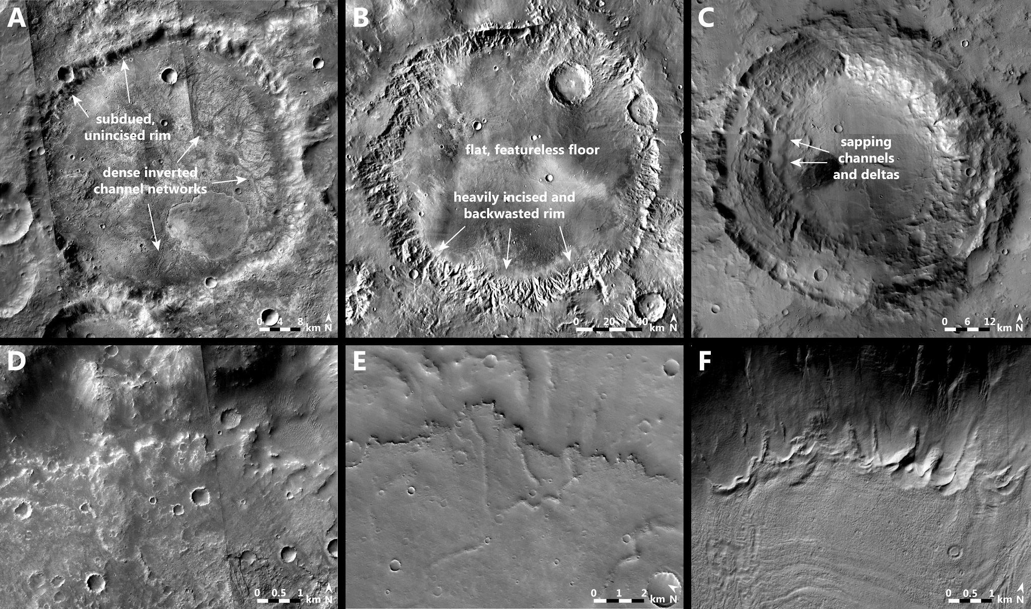
Comparison of crater B to typical degraded craters on Mars. (A) Defining features of crater B include a subdued, unincised rim and dense crater floor inverted channel networks. (B) Dawes, a 'classic' degraded crater (9.2°S, 38.0°E), has a heavily incised and backwasted rim with a flat, relatively featureless floor. (C) A typical groundwater-fed crater (27.9°N, 11.5°E) displays sapping channels and deltas. The three craters are shown at the same relative scale in order to facilitate comparison. (D) Laterally continuous segment of upslope-facing scarps in the northern floor of crater B. (E) Upslope-facing scarp identified by Davis et al. in Barth crater in Arabia Terra (7.4°N, 25.7°E). (F) Upslope-facing scarps formed by retreating cold-based glaciers in an Amazonian-aged crater in Terra Sirenum, southwest of Newton basin (42.9°S, 196.7°E). Boatwright & Head (2021).
The presence of inverted channels, the abundance of transverse aeolian ridges, and the exposures of crater floor substrate material testify to the removal of several tens of meters of sediment from the Crater B floor subsequent to the fluvial and lacustrine activity. Insight into the nature of depositional and inversion processes can be gained from analyses of the larger and more extensive inverted channels associated with regional valley networks. Davis et al. characterised large inverted fluvial channels in Arabia Terra (generally 1-2 km wide, over 10 km long). Most of these are found immediately downslope of, or deposited within, regionally integrated valley networks, or within the same watershed if not directly associated with a valley network. A global survey reached similar conclusions about the distribution of large inverted fluvial channels (more than 70 m wide), finding that all were downslope of valley networks. These types of inverted channels most likely represent the depositional counterparts to traditional valley networks forming in the Late Noachian–Early Hesperian.
In the case of inverted fluvial channels in Arabia Terra, Davis et al. noted that valley to ridge transitions are correlated with slope breaks, indicating that the ridges are likely to have formed out of alluvial channel deposits. In 2007 Caleb Fassett and James identified inverted channels in Arabia Terra in association with a Noachian–Hesperian mantling deposit. The characteristics of this mantling unit suggest that volatiles were incorporated either during or immediately following its emplacement. They suggested that the inversion process involved sublimation and volatile loss, combined with aeolian deflation of unconsolidated material, leaving behind indurated fluvial channel deposits.
Topographic data indicate that the inverted channels in Crater B initiate at a slope break at the base of the crater wall, which matches the depositional style inferred by Davis et al. The thermophysical properties of the channels from THEMIS quantitative thermal inertia data are intermediate between the high-TI, light-toned crater floor bedrock and the relatively low-TI mantling materials on the crater rim and wall. According to Rebecca Williams, Jeffrey Moersch, and Robin Fergason, this would suggest that the inverted channels are more competent than the surrounding loose sediment and were formed through induration. However, spectral identifications of primary mafic mineral phases in the inverted channels are consistent with limited post-depositional alteration, and HiRISE images of the channels show active weathering and talus slopes uncharacteristic of indurated materials, so grain armoring cannot be ruled out as an alternative.
Boatwright and Head interpret the fluvial channel deposits in Crater B to have originally contained alluvial sediment lags derived from mantling deposits within the crater. The nature of the mantling deposit is likely to have been similar to those observed in Arabia Terra, and elsewhere in Terra Sabaea, consisting of airfall deposits from climate-driven dust and volatile deposition, atmospherically transported impact ejecta, or plinian volcanic tephra. Fluvial processes concentrated sediments within the fluvial channels and transported suspended loads either into lakes or floodplains, where they were eventually removed or redistributed. Topographic inversion resulted from aeolian deflation, perhaps combined with sublimation of co-deposited volatile layers and cement, as suggested by Fassett and Head for the mantling unit in Arabia Terra. The source of the alluvial sediment remaining in the inverted channels is thus likely to have been from previous mantle emplacement and/or material shed from the adjacent crater wall.
The ridges and basins documented within the closed-source drainage basin Crater B indicate an integrated fluvial–lacustrine system that formed completely internally to the crater basin with no apparent breaches or other incoming fluvial drainage sources or outgoing drainage sinks. Fluvial channels within the crater subsequently underwent topographic inversion into ridges, most likely involving aeolian removal of loosely consolidated sediment and/or sublimation of volatiles. Boatwright and Head compare their observations in Crater B to previously presented models of crater degradation and fluvial incision on Mars to determine the most plausible water sources in the crater and the origins of the ridges, basins, alcoves, and upslope-facing scarps.
The distribution of degraded Noachian-aged craters in the southern highlands suggests that the processes responsible for their degradation were widespread. Dawes Crater has many of the hallmarks as typical of Noachian crater degradation: the crater wall has been heavily incised and backwasted by fluvial erosion, and the flat, relatively featureless floor has been infilled presumably by laterally transported sediments. By comparison, the wall and rim of Crater are much more subdued, and no fluvial incision is observed. The floor of Crater B contains a dense network of inverted fluvial channels that begin abruptly at the base of the crater wall and do not extend up to or beyond the rim. For these reasons, Boatwright and Head believe external drainage from a regionally integrated valley network or inlet channels is the least likely water source in Crater B.
Irwin et al. noted the possibility of groundwater flow into Crater B due to higher surrounding intercrater topography. Many groundwater-fed crater basin lakes elsewhere on Mars contain steep, short valleys that erode into the crater wall. Salese et al. interpreted these as groundwater sapping valleys, noting their low drainage density and approximately equal channel width downstream. Crater B shows no evidence for groundwater sapping valleys as described by Salese et al., and the higher drainage density and stream order of the inverted channels on the crater floor are atypical of groundwater sapping processes. While a few groundwater-fed lakes do display inverted fluvial morphologies, these are almost always associated with sapping valleys. Although groundwater-fed lakes appear to be less filled with sediment than other crater basin lakes, the fluvial activity resulting from groundwater sapping was still sufficient to transport sediment into fans and deltas. Crater B contains no discernible landforms of this nature. The upslope-facing scarps appear superficially similar to some features found in certain groundwater-fed crater basin lakes; however, in Crater B, the steeper sides face upslope in the opposite sense of a typical terrace that, in a groundwater-fed lacustrine environment, would be downcut on the side facing downslope. Finally, the Crater B floor elevation (+ 2 km) is inconsistent with the elevation that groundwater-fed lakes on Mars occupy, usually below –4 km. Thus, Boatwright and Head believe that groundwater sapping is an unlikely water source in Crater B.
Boatwright and Head's observations in Crater B do not match craters modified by rainfall-derived fluvial breaching or groundwater sapping. As noted by Bon Craddock and Alan Howard, '…it is possible that…any surface runoff was the result of snowmelt.' Snowmelt may refer to any kind of melting resulting from the heating of surficial water in its solid phase, and we thus investigate this option as a water source in Crater B.
Could glaciation have occurred in the highlands of Noachian Mars, forming a readily available water source for the crater floor fluvial and lacustrine features in Crater B? Such a scenario is one potential outcome of the colder climate predicted by early Mars climate modeling studies and is consistent with typical Noachian crater wall slopes. Modelbased predictions of the likely range of geothermal heat fluxes and surface temperatures in the Noachian further suggest that any glacial activity would have been cold-based, generally ruling out the formation of basal melt features such as eskers that can appear superficially similar to inverted fluvial channels. Boatwright and Head further disfavor an esker interpretation for the ridges in Crater B because (1) eskers are often observed flowing along or against gradient, while the ridges in Crater B flow strictly along gradient; and (2) eskers may have a range of ridge crest morphologies including sharp peaks, while the ridges in Crater B are almost exclusively flat-topped.
Instead, top-down (supraglacial) melting of a cold-based glacier could occur in cases where air temperatures locally exceeded 273 K (0°C). In the more recent Amazonian, cold-based glaciation in crater interiors has produced a variety of distinctive morphological features. Ice deposits on steep slopes underwent glacial flow down to the exposed base of crater walls, forming terminal and lateral moraines whose boundaries are preserved as upslope-facing scarps. In larger craters with shallower wall slopes, numerous glaciofluvial valley networks formed as a result of glacial meltwater drainage below the scarps.
Much as in the more recent Amazonian examples, glacial ice coldtrapped in the alcoves of Crater B would have undergone flow, ablation, and melting, resulting in the buildup of marginal sediments at the base of the crater wall that now comprise the upslope-facing scarps and their slope-parallel extensions. Additional top-down melting at the glacial front would then result in proglacial fluvial erosion of sediments derived either directly from glacial debris deposition or from preexisting aeolian mantles. Proglacial meltwater channels are also observed in conjunction with seasonal top-down melting processes in the Antarctic McMurdo Dry Valleys. In some cases, ridges may form between active channels as the result of stranded ice-cored ground exposed by glacial retreat; this process is distinct from the topographic inversion that Boatwright and Head interpret for the formation of the ridges in Crater B.
Boatwright and Head conclude that episodic top-down melting of a cold-based crater wall glacier within Crater B represents a plausible water source to form the observed fluvial and lacustrine features. This closed-source drainage basin' water source differs from previously considered hypotheses for the formation of other types of palaeolakes on Mars, which call on water sources external to the crater. In addition, ambient cold climates would favor the emplacement of climate-driven snow, ice and dust mantles. The loss of such volatile components by ablation could significantly assist in the topographic inversion and mantle loss processes in Crater B, as also envisioned in Arabia Terra.
Boatwright and Head describe a Noachian closed-source drainage basin, a new type of palaeolake on Mars with neither inlet nor outlet channels. An ensemble of ridges, basins, alcoves, and upslope-facing scarps found within the crater provides evidence for possible drainage sources and mechanisms leading to the formation of inverted fluvial channels and lacustrine deposits on the crater floor. Boatwright and Head find that the features within the crater are unlikely to have formed in a warm and wet early Mars climate dominated by fluvial valley network incision and crater breaching. The occurrence of inverted channels within the crater differs from descriptions of large, regionally integrated inverted channels that appear to be the depositional counterparts to traditional valley networks. The crater also does not share many of the characteristics of groundwater-fed crater basin lakes (fans, deltas, shorelines), and Boatwright and Head thus consider groundwater to be an unlikely source of water in the closed-source drainage basin crater.
Alternatively, Boatwright and Head have explored the suggestion of Bob Craddock and Alan that surface runoff and crater degradation may have been the result of snowmelt. Boatwright and Head find that the ensemble of features within the crater (e.g. lack of wall-breaching fluvial channels, the presence of alcoves and upslope-facing scarps, and the nature and location of inverted fluvial channels and lacustrine deposits on the crater floor) are all consistent with the top-down melting of a cold-based crater wall glacier, proglacial drainage in fluvial meltwater channels, and ponding of meltwater in lakes on the crater floor.
The interpretation of the features in the closed-source drainage basin crater as the result of top-down melting of a cold-based crater wall glacier in the southern highlands has significant implications for our understanding of the ambient early Mars climate. Several workers have described mechanisms for transient atmospheric heating and ice melting in an otherwise subfreezing climate, but specific geomorphic evidence for Noachian glaciofluvial activity has only occasionally been suggested. Boatwright and Head describe for the first time observational evidence of proglacial palaeolakes and inverted fluvial channels on Noachian Mars.
The proglacial fluvial and lacustrine features in this closed-source drainage basin provide the necessary criteria for recognising distinctive geomorphic features that could be formed via cold-based glacial processes elsewhere on Mars. Boatwright and Head's initial investigations of the broader region surrounding Crater B indicate that these types of features are widespread within craters of similar age, particularly along the high-standing escarpments of the Hellas basin rim. Among these additional examples, Crater B appears to represent an end member with the most well-preserved examples of proglacial fluvial and lacustrine features within a closed-source drainage basin crater. This ensemble of features can be compared to those in other nearby craters in order to place Crater B into a regional and global geologic context and to assess both ambient and changing climate conditions.
See also...


Follow Sciency Thoughts on Facebook.
Follow Sciency Thoughts on Twitter.


.png)


.png)