Showing posts with label Barren Island. Show all posts

Friday, 26 October 2018

Eruptions on Barren Island.

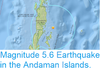
Barren Island, an uninhabited volcanic island belonging officially to India's Andaman Islands (making it India's only active volcano), began erupting on, or shortly before, 25 September 2018, when the Middle InfraRed Observation of Volcanic Activity (MIROVA) monitoring system, which uses data from the Moderate-Resolution Imaging Spectroradiometer (MODIS) system on the Terra (EOS AM) and Aqua (EOS PM) satellites detected a thermal anomaly on the northwest flank of the cone, interpretted as a recent lava flow. Since then images from the Sentinal Satetellite system have shown lava flows reaching the sea on the island, and a visit to the volcano by a boat from tour company Andaman Aquaholics has directly witnessed this flow.

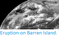
Eruption on Barren Island on 23 October 2018, as imaged by the Sentinal Satellite system. European Space Agency.

Barren Island is about 100 km to the east of the main Andaman Island group and about 450 km west of the coast of southern Myanmar. The island is about 3 km in diameter and rises 354 m above sea level. It is the only active volcano in the region, though it forms part of a group with a number of dormant volcanoes including Narcondam Island and Alcock and Sewell seamounts.

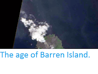
 Lava flow on Barren Island on 20 October 2018. Andaman Aquaholics.

The volcanoes sit on the Burma (or Burmese) Plate, a small tectonic plate underlying the Andaman Islands, part of the eastern Indian Ocean and the western part of Sumatra. To the west of the Andaman Islands this plate is being subducted beneath the Indian Plate, but to the east the situation is more complex. The Burma Plate is being pushed northward relative to the Eurasia and the Sunda Plate (which underlies eastern Sumatra, Java, southern Southeast Asia, most of Borneo and the western Philippines) by the northward movement of the Indian Plate, but there is an area of seafloor spreading beneath the Andaman Sea (separating the Andaman Islands from Southeast Asia), which in turn causes stresses within the Burma Plate, leading to a zone of faulting upon which the volcanic islands and seamounts are situated.

(Left) The movement of the Burma and surrounding plates. Sheth et al. (2011) (Right) Tectonic stresses within and around the Burma Plate. Renjith (2013).

See also...

https://sciencythoughts.blogspot.com/2018/02/magnitude-56-earthquake-in-andaman.htmlhttps://sciencythoughts.blogspot.com/2017/02/ongoing-eruptions-on-barren-island.html
http://sciencythoughts.blogspot.co.uk/2015/06/eruption-on-barren-island.htmlhttp://sciencythoughts.blogspot.co.uk/2014/04/the-age-of-barren-island.html
http://sciencythoughts.blogspot.co.uk/2013/10/eruptions-on-barren-island.html
Follow Sciency Thoughts on Facebook.

Saturday, 18 February 2017

Ongoing eruptions on Barren Island.

A group of scientists from India's National Institute of Oceanography has reported observing eruptions on Barren Island Volcano in the Andaman Islands. The scientists visited the island on 23 and 26 January 2017 onboard the Research Vessel Sindhu Sankalp, in order to collect marine sediment samples. They witnessed a series of small strombolian-type eruptive episodes, each lasting about 5-10 minutes, with ash and lava being thrown from the crater of the volcano and clouds of smoke around its summit. Marine sediments collected near the island were found to contain black pyroclastic sediments associated with recent eruptions. The scientists did not land on the island itself as it was deemed unsafe.

Eruption on Barren Island in January 2017. National Institute of Oceanography.

Barren Island is an uninhabited volcanic island belonging officially to India's Andaman Islands (making it India's only active volcano), though it is about 100 km to the east of the main Andaman Island group and about 450 km west of the coast of southern Myanmar. The island is about 3 km in diameter and rises 354 m above sea level. It is the only active volcano in the region, though it forms part of a group with a number of dormant volcanoes including Narcondam Island and Alcock and Sewell seamounts.

 The approximate location of Barren Island. Google Maps.

The volcanoes sit on the Burma (or Burmese) Plate, a small tectonic plate underlying the Andaman Islands, part of the eastern Indian Ocean and the western part of Sumatra. To the west of the Andaman Islands this plate is being subducted beneath the Indian Plate, but to the east the situation is more complex. The Burma Plate is being pushed northward relative to the Eurasia and the Sunda Plate (which underlies eastern Sumatra, Java, southern Southeast Asia, most of Borneo and the western Philippines) by the northward movement of the Indian Plate, but there is an area of seafloor spreading beneath the Andaman Sea (separating the Andaman Islands from Southeast Asia), which in turn causes stresses within the Burma Plate, leading to a zone of faulting upon which the volcanic islands and seamounts are situated.

 (Left) The movement of the Burma and surrounding plates. Sheth et al. (2011) (Right) Tectonic stresses within and around the Burma Plate. Renjith (2013).

See also...


http://sciencythoughts.blogspot.co.uk/2014/04/the-age-of-barren-island.html
http://sciencythoughts.blogspot.co.uk/2015/06/eruption-on-barren-island.html


http://sciencythoughts.blogspot.co.uk/2013/10/eruptions-on-barren-island.html

Follow Sciency Thoughts on Facebook.

Sunday, 7 June 2015

Eruption on Barren Island.

The Darwin Volcanic Ash Advisory Center issued a warning to aviation after an ash column was spotted over Barren Island, an active volcano in the Andaman Islands, by the Japan Meteorological Agency's MTSAT-2 satellite on Saturday 6 June 2015. The ash column rose about 3 km above the volcano and drifted about 35 km to the east. Observations in infra-red also spotted a hotspot on the island, which may indicate hot lava on or close to the surface.

MSAT infra-red image of East Asia. Barren Island is on the left of the image, west of the northern Malay Peninsula and to the south of Myanmar. Japan Meteorological Agency.

Barren Island is an uninhabited volcanic island belonging officially to India's Andaman Islands (making it India's only active volcano), though it is about 100 km to the east of the main Andaman Island group and about 450 km west of the coast of southern Myanmar. The island is about 3 km in diameter and rises 354 m above sea level. It is the only active volcano in the region, though it forms part of a group with a number of dormant volcanoes including Narcondam Island and Alcock and Sewell seamounts.

The approximate location of Barren Island. Google Maps.

The volcanoes sit on the Burma (or Burmese) Plate, a small tectonic plate underlying the Andaman Islands, part of the eastern Indian Ocean and the western part of Sumatra. To the west of the Andaman Islands this plate is being subducted beneath the Indian Plate, but to the east the situation is more complex. The Burma Plate is being pushed northward relative to the Eurasia and the Sunda Plate (which underlies eastern Sumatra, Java, southern Southeast Asia, most of Borneo and the western Philippines) by the northward movement of the Indian Plate, but there is an area of seafloor spreading beneath the Andaman Sea (separating the Andaman Islands from Southeast Asia), which in turn causes stresses within the Burma Plate, leading to a zone of faulting upon which the volcanic islands and seamounts are situated.

(Left) The movement of the Burma and surrounding plates. Sheth et al. (2011). (Right) Tectonic stresses within and around the Burma Plate. Renjith (2013).

See also...

Barren Island is an uninhabited volcanic island belonging officially to India's Andaman Islands (making it India's only active volcano), though it is about 100 km to the east of the main Andaman Island group and about 450 km west of the coast of southern Myanmar. The island is about 3 km in diameter and rises 354 m above sea level. It is the only active volcano in the region...

NASA's MODIS (Moderate Resolution Imaging Spectroradiometer) system, mounted on the Terra (EOS AM) and Aqua (EOS PM) satellites, detected a hotspot developing over the Baren Island Volcano in the Andaman Islands over the period 10-16 October...


Follow Sciency Thoughts on Facebook.

Thursday, 3 April 2014

The age of Barren Island.

Barren Island is an uninhabited volcanic island belonging officially to India's Andaman Islands (making it India's only active volcano), though it is about 100 km to the east of the main Andaman Island group and about 450 km west of the coast of southern Myanmar. The island is about 3 km in diameter and rises 354 m above sea level. It is the only active volcano in the region, though it forms part of a group with a number of dormant volcanoes including Narcondam Island and Alcock and Sewell seamounts.

Satelite image of an eruption on the Barren Island volcano captured by NASA's Earth Observing 1 satellite on 25 September 2010. Earth Observatory.

The volcanoes sit on the Burma (or Burmese) Plate, a small tectonic plate underlying the Andaman Islands, part of the eastern Indian Ocean and the western part of Sumatra. To the west of the Andaman Islands this plate is being subducted beneath the Indian Plate, but to the east the situation is more complex. The Burma Plate is being pushed northward relative to the Eurasia and the Sunda Plate (which underlies eastern Sumatra, Java, southern Southeast Asia, most of Borneo and the western Philippines) by the northward movement of the Indian Plate, but there is an area of seafloor spreading beneath the Andaman Sea (separating the Andaman Islands from Southeast Asia), which in turn causes stresses within the Burma Plate, leading to a zone of faulting upon which the volcanic islands and seamounts are situated.

In 1991 Barren Island began erupting after 159 years of dormancy. As an active volcano in the Anderman Sea it presents a direct potential threat to settlements in the Anderman and Nicobar Islands, and potentially the nations of Southeast Asia, as well as a tsunami risk to nations around the Indian Ocean, and a threat to aviation, making an understanding of the eruptive history of the volcano a priority for Indian vulcanologists. Previous studies have revealed a series of seven ash and tephra (volcanic material) layers on the island, the oldest of which dates back to 70 000 years ago, although the island and its volcano are thought to be somewhat older.

In a paper published in the journal Currant Science on 10 April 2013, Jyotiranjan Ray of the Physical Research Laboratory, Kanchan Pande of the Department of Earth Sciences at the Indian Institute of Technology Bombay and Neeraj Awasthi, also of the Physical Research Laboratory, describe the results of an Argon-Argon isotope study of minerals from tephra close to Barren Island.

Argon-Argon dating relies on determining the ratio of radioactive Argon⁴⁰ to non-radioactive Argon³⁹ within minerals from igneous or metamorphic rock (in this case volcanic ash) to determine how long ago the mineral cooled sufficiently to crystalize. The ratio of Argon⁴⁰ to Argon³⁹ is constant in the atmosphere, and this ratio will be preserved in a mineral at the time of crystallization. No further Argon³⁹ will enter the mineral from this point, but Argon⁴⁰ is produced by the decay of radioactive Potassium⁴⁰, and increases in the mineral at a steady rate, providing a clock which can be used to date the mineral.

Ray et al. studied plagioclase grains (plagioclase is a common mineral in volcanic rocks) from two tephra layers, previously dated to no more than 61 000 years old. They obtained dates of around 1.8 million years for the minerals. They infer that the minerals were formed within the volcano at around this time, and ejected around 61 000 years ago (this is not unusual for volcanos). From this they conclude that active volcanism has been occurring on the Barren Island volcano for at least 1.8 million years (though the island itself is not necessarily this old.

Backscattered X-ray images of two typical lithic clasts. Mineral grains (phenocrysts) and vesicular matrix are marked. Plag, Plagioclase; T-Mt, Titaniferous magnetite; Ol, Olivine; Cpx, Clino-pyroxene. Ray et al. (2013).


See also...


Follow Sciency Thoughts on Facebook.

Sunday, 20 October 2013

Eruptions on Barren Island.

NASA's MODIS (Moderate Resolution Imaging Spectroradiometer) system, mounted on the Terra (EOS AM) and Aqua (EOS PM) satellites, detected a hotspot developing over the Baren Island Volcano in the Andaman Islands over the period 10-16 October 2013. On 15 October an image taken at visual wavelengths by the Terra Satellite appeared to show a volcanic plume over the island, and the Indian Navy confirmed that a surveillance plane had spotted smoke and lava on the island. On 17 October the Darwin Volcanic Ash Advisory Center issued a warning to aviation of an ash column rising 3.6 km above the island and drifting to the northwest.

A previous eruption on Barren Island. Wikimapia.

Barren Island is an uninhabited volcanic island belonging officially to India's Andaman Islands (making it India's only active volcano), though it is about 100 km to the east of the main Andaman Island group and about 450 km west of the coast of southern Myanmar. The island is about 3 km in diameter and rises 354 m above sea level. It is the only active volcano in the region, though it forms part of a group with a number of dormant volcanoes including Narcondam Island and Alcock and Sewell seamounts.

The approximate location of Barren Island. Google Maps.

The volcanoes sit on the Burma (or Burmese) Plate, a small tectonic plate underlying the Andaman Islands, part of the eastern Indian Ocean and the western part of Sumatra. To the west of the Andaman Islands this plate is being subducted beneath the Indian Plate, but to the east the situation is more complex. The Burma Plate is being pushed northward relative to the Eurasia and the Sunda Plate (which underlies eastern Sumatra, Java, southern Southeast Asia, most of Borneo and the western Philippines) by the northward movement of the Indian Plate, but there is an area of seafloor spreading beneath the Andaman Sea (separating the Andaman Islands from Southeast Asia), which in turn causes stresses within the Burma Plate, leading to a zone of faulting upon which the volcanic islands and seamounts are situated.

The movement of the Burma and surrounding plates. Sheth et al. (2011).

Tectonic stresses within and around the Burma Plate. Renjith (2013).


Follow Sciency Thoughts on Facebook.