Showing posts with label Burma Plate. Show all posts

Saturday, 27 November 2021

Magnitude 6.2 Earthquake in the India-Myanmar border region.

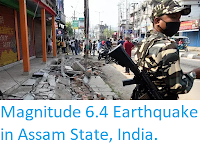
The Indian National Centre for Seismology recorded a Magnitude 6.1 Earthquake at a depth of 27 km, in the India-Myanmar border region, about 140 km to the southeast of the city of Aizawl in Mizoram State, India, at about 5.15 am local time on Friday 26 November 2021 (slightly after 11.45 pm on Thursday 25 November, GMT). Earthquakes this large and at this shallow a depth are considered to be extremely dangerous, as much energy is being dissipated close to the surface, where it can potentially do the most harm, although on this occasion there are no reports of any damage or casualties. The Earthquake was felt across northern Myanmar, Bangladesh, northeast India, and Bhutan.

 
The approximate location of the 26 November 2021 India-Myanmar border region Earthquake. USGS.

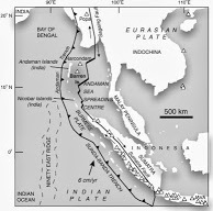
Earthquake activity in northeast India is influenced by the uplift of the Tibetan Plateau, due to the impact of India into Eurasia to the south. The Indian Plate is moving northwards at a rate of 5 cm per year, causing it to impact into Eurasia, which is also moving northward, but only at a rate of 2 cm per year. The collision of the Indian and Eurasian plates has led to the formation of the Himalayan Mountains, the Tibetan Plateau, and the mountains of southwest China, Central Asia and the Hindu Kush.

 
Block diagram showing how the impact of the Indian Plate into Eurasia is causing uplift on the Tibetan Plateau. Jayne Doucette/Woods Hole Oceanographic Institution.

The India-Myanmar border region is an area particularly prone to Earthquakes; much of Myanmar lies on the Burma Plate, a small tectonic plate caught between  the Eurasian Plate to the northeast, the Indian Plate to the west and southwest and the Sunda Plate to the southeast. As these larger plates move together the Burma Plate is being squeezed and fractured, with a major fault line, the Kabaw Fault, having formed across much of the north of the country, along which the Burma Plate is slowly splitting. Most Earthquakes in the region are caused by movement on this fault.

 
The movement of the Burma and surrounding plates. Sheth et al. (2011).

Witness accounts of quakes can help geologists to understand these events and the rock structures that cause them. If you felt this quake you can report it to the Indian National Centre for Seismology here.

See also...


Follow Sciency Thoughts on Facebook.

Follow Sciency Thoughts on Twitter


Sunday, 1 September 2019

Magnitude 5.5 Earthquake in the Sagaing Region of Myanmar.

The United States Geological Survey recorded a Magnitude 5.5 Earthquake at a depth of 10.0 km in Sagaing Region, Myanmar, about 26 km to the northwest of the city of Shwebo, slightly before 9.40 pm local time (slightly before 3.10 am GMT) on Saturday 31 August 2019. There are no reports of any injuries following this event, though some damage to buildings has occurred. People have reported felling the quake across northern Myanmar, as well as in parts of northeastern India, and Yunnan Province, China.
 
Damage to a pagoda in YayU following an Earthquake in the Sagaing Region of Myanmar on 31 August 2019. Yarza Dhamma Htantapin/Eleven Media.
 
Myanmar is an area fairly prone to Earthquakes; much of the country lies on the Burma Plate, a small tectonic plate caught between  the Eurasian Plate to the northeast, the Indian Plate to the west and southwest and the Sunda Plate to the southeast. As these larger plates move together the Burma Plate is being squeezed and fractured, with a major fault line, the Kabaw Fault, having formed across much of the north of the country, along which the Burma Plate is slowly splitting. Most Earthquakes in the region are caused by movement on this fault.
   
The movement of the Burma and surrounding plates. Sheth et al. (2011).

Witness accounts of Earthquakes can help geologists to understand these events, and the structures that cause them. The international non-profit organisation Earthquake Report is interested in hearing from people who may have felt this event; if you felt this quake then you can report it to Earthquake Report here.
 
See also...
 
https://sciencythoughts.blogspot.com/2019/08/landslide-kills-at-least-61-in-mon.htmlhttps://sciencythoughts.blogspot.com/2019/07/landslide-kills-at-least-nineteen-at.html
https://sciencythoughts.blogspot.com/2019/05/magnitude-51-earthquake-in-sagaing.htmlhttps://sciencythoughts.blogspot.com/2019/04/collapse-at-myanmar-ruby-mine-kills-two.html
https://sciencythoughts.blogspot.com/2019/04/mudslide-at-myanmar-jade-mine-kills.htmlhttps://sciencythoughts.blogspot.com/2018/11/magnitude-52-earthquake-in-chine-state.html
Follow Sciency Thoughts on Facebook.

Wednesday, 22 May 2019

Magnitude 5.6 Earthquake to the north of Great Andaman Island.

The United States Geological Survey recorded a Magnitude 5.6 Earthquake at a depth of 10.0 km a little over 30 km to the north of Great Andaman Island, slightly before 3.10 am local time (slightly before 0.40 am GMT) on Wednesday 22 May 2018. There are no reports of any damage or injuries associated with this event, though people have reported feeling in in Port Blair, the capitol of the Andaman and Nicobar Islands, which is around 250 km to the south of the Earthquake's epicentre.
 
The approximate location of the 22 May 2019 Nicobar Islands Earthquake. USGS.
 
The Nicobar Islands sit on the Burma (or Burmese) Plate, a small tectonic plate which underlies part of the eastern Indian Ocean and the western part of Sumatra. To the west of the Nicobar Islands this plate is being subducted beneath the Indian Plate, but to the east the situation is more complex. The Burma Plate is being pushed northward relative to the Eurasia and the Sunda Plate (which underlies eastern Sumatra, Java, southern Southeast Asia, most of Borneo and the western Philippines) by the northward movement of the Indian Plate. There is also an area of seafloor spreading beneath the Andaman Sea (separating the Andaman and Nicobar Islands from Southeast Asia), which in turn causes stresses within the Burma Plate, leading to a zone of faulting upon which the Andaman and Nicobar Islands are situated.
 
(Left) The movement of the Burma and surrounding plates. Sheth et al. (2011.(Right) Tectonic stresses within and around the Burma Plate. Renjith (2013).

Witness accounts of Earthquakes can help geologists to understand these events, and the structures that cause them. The international non-profit organisation Earthquake Report is interested in hearing from people who may have felt this event; if you felt this quake then you can report it to Earthquake Report here.
 
See also...
 
http://sciencythoughts.blogspot.com/2019/05/magnitude-43-earthquake-to-east-of.htmlhttps://sciencythoughts.blogspot.com/2018/10/eruptions-on-barren-island.html
https://sciencythoughts.blogspot.com/2018/02/magnitude-56-earthquake-in-andaman.htmlhttps://sciencythoughts.blogspot.com/2017/02/ongoing-eruptions-on-barren-island.html
http://sciencythoughts.blogspot.co.uk/2015/06/eruption-on-barren-island.htmlhttp://sciencythoughts.blogspot.co.uk/2014/04/the-age-of-barren-island.html
Follow Sciency Thoughts on Facebook.

Friday, 17 May 2019

Magnitude 4.3 Earthquake to the east of the Nicobar Islands.

The United States Geological Survey recorded a Magnitude 4.7 Earthquake at a depth of 10.0 km a little over 100 km to the east of the Nicobar Islands, slightly before 7.05 am local time (slightly before 92.35 am GMT) on Friday 17 May 2018. There are no reports of any damage or injuries associated with this event, and it is highly unlikely that it was felt at all, due to its distance from land.
 
The approximate location of the 17 May 2019 Nicobar Islands Earthquake. USGS.
.
The Nicobar Islands sit on the Burma (or Burmese) Plate, a small tectonic plate which underlies part of the eastern Indian Ocean and the western part of Sumatra. To the west of the Nicobar Islands this plate is being subducted beneath the Indian Plate, but to the east the situation is more complex. The Burma Plate is being pushed northward relative to the Eurasia and the Sunda Plate (which underlies eastern Sumatra, Java, southern Southeast Asia, most of Borneo and the western Philippines) by the northward movement of the Indian Plate. There is also an area of seafloor spreading beneath the Andaman Sea (separating the Andaman and Nicobar Islands from Southeast Asia), which in turn causes stresses within the Burma Plate, leading to a zone of faulting upon which the Andaman and Nicobar Islands are situated.
 
 (Left) The movement of the Burma and surrounding plates. Sheth et al. (2011.(Right) Tectonic stresses within and around the Burma Plate. Renjith (2013).
 
See also...
 
https://sciencythoughts.blogspot.com/2018/12/hundreds-dead-after-krakatau-eruption.htmlhttps://sciencythoughts.blogspot.com/2018/10/eruptions-on-barren-island.html
https://sciencythoughts.blogspot.com/2018/10/landslides-and-flash-floods-kill-36-in.htmlhttps://sciencythoughts.blogspot.com/2018/06/eruption-on-mount-kerinci-sumatra.html
https://sciencythoughts.blogspot.com/2018/04/explosion-at-illegal-oil-well-kills-21.htmlhttps://sciencythoughts.blogspot.com/2018/03/three-dead-as-flash-flooding-hits.html
Follow Sciency Thoughts on Facebook.

Sunday, 5 May 2019

Magnitude 5.1 Earthquake in the Sagaing Region of Myanmar.

The United States Geological Survey recorded a Magnitude 5.1 Earthquake at a depth of 100.3 km in Sagaing Region, Myanmar, about 70 km to the southeast Indian border, slightly before 5.35 pm local time (slightly before 11.05 am GMT) on Saturday 4 May 2019. There are no reports of any damage or injuries following this event, though a large number of people have reported feeling it across much of northeastern India, which is roughly what would be expected of a quake of this size at this depth, which releases a lot of energy, but where that energy dispersed over a wide area before it reaches the surface.
 
The approximate location of the 4 May 2019 Sagaing Region Earthquake. USGS.
 
 Myanmar is an area fairly prone to Earthquakes; much of the country lies on the Burma Plate, a small tectonic plate caught between  the Eurasian Plate to the northeast, the Indian Plate to the west and southwest and the Sunda Plate to the southeast. As these larger plates move together the Burma Plate is being squeezed and fractured, with a major fault line, the Kabaw Fault, having formed across much of the north of the country, along which the Burma Plate is slowly splitting. Most Earthquakes in the region are caused by movement on this fault.
 
 The movement of the Burma and surrounding plates. Sheth et al. (2011).
 
Witness accounts of Earthquakes can help geologists to understand these events, and the structures that cause them. The international non-profit organisation Earthquake Report is interested in hearing from people who may have felt this event; if you felt this quake then you can report it to Earthquake Report here.
 
See also...
 
https://sciencythoughts.blogspot.com/2019/04/collapse-at-myanmar-ruby-mine-kills-two.htmlhttps://sciencythoughts.blogspot.com/2019/04/mudslide-at-myanmar-jade-mine-kills.html
https://sciencythoughts.blogspot.com/2018/11/magnitude-52-earthquake-in-chine-state.htmlhttps://sciencythoughts.blogspot.com/2018/07/fifteen-confirmed-deaths-following.html
https://sciencythoughts.blogspot.com/2018/06/thirteeen-people-killed-in-series-of.htmlhttps://sciencythoughts.blogspot.com/2018/06/landslide-kills-five-in-mandalay-region.html
Follow Sciency Thoughts on Facebook.

Monday, 12 November 2018

Magnitude 5.2 Earthquake in Chine State, Myanmar.

The United States Geological Survey recorded a Magnitude 5.2 Earthquake at a depth of 50.4 km in Chin State, Myanmar, about 47 km to the southwest Indian border, at about 11.45 pm local time (about 5.15 pm GMT) on Saturday 10 November 2018. There are no reports of any damage or injuries following this event, though a large number of people have reported feeling it across much of northeastern India and in parts of Bangladesh.

The approximate location of the 10 November 2018 Chin State Earthquake. USGS.

Myanmar is an area fairly prone to Earthquakes; much of the country lies on the Burma Plate, a small tectonic plate caught between  the Eurasian Plate to the northeast, the Indian Plate to the west and southwest and the Sunda Plate to the southeast. As these larger plates move together the Burma Plate is being squeezed and fractured, with a major fault line, the Kabaw Fault, having formed across much of the north of the country, along which the Burma Plate is slowly splitting. Most Earthquakes in the region are caused by movement on this fault.
 
Witness accounts of Earthquakes can help geologists to understand these events, and the structures that cause them. The international non-profit organisation Earthquake Report is interested in hearing from people who may have felt this event; if you felt this quake then you can report it to Earthquake Report here.

See also...

https://sciencythoughts.blogspot.com/2018/10/eruptions-on-barren-island.htmlhttps://sciencythoughts.blogspot.com/2018/07/fifteen-confirmed-deaths-following.html
https://sciencythoughts.blogspot.com/2018/07/landslide-kills-nin-in-manipur-india.htmlhttps://sciencythoughts.blogspot.com/2018/06/landslide-kills-four-in-arunachal.html
https://sciencythoughts.blogspot.com/2018/06/thirteeen-people-killed-in-series-of.htmlhttps://sciencythoughts.blogspot.com/2018/06/flooding-kills-23-in-northeastern-india.html
Follow Sciency Thoughts on Facebook.