Showing posts with label Bosnia and Herzegovinia. Show all posts

Sunday, 24 April 2022

Magnitude 5.7 Earthquake in Bosnia and Herzegovina kills at least one.

The Centre Sismologique Euro-Méditerranéen recorded a Magnitude 5.7 Earthquake at a depth of 5 km, roughly 42 km to the southeast of the city of Mostar in southern Bosnia and Herzegovina, slightly after 11.05 pm local time (slightly after 9.05 pm GMT) on Friday 22 April 2022. People have felt this event across the western Balkan Peninsula and much of Italy, with reports of damage from several towns and cities in the region. A 28-year-old woman died and several other people were injured in the town of Stolac, near Mostar, when a boulder dislodged from a hillside by the quake crashed into a house.

 
The approximate location of the 22 April 2022 Bosnia and Herzegovina Earthquake. USGS.

Bosnia and Herzegovina, and the other states of the western Balkan Peninsula, form the eastern margin of the Adriatic Plate, a piece of the African Plate that has broken away and is now wedged into the southern part of the Eurasian Plate. This is being squeezed by the impact of Africa into Europe from the south, which is pushing western Italy, which sits on the Eurasian Plate, to the east, and Greece and Turkey, which sit on the Aegean and Anatolian Plates, to the west. This squeezing leads to uplift around the margins of the Adriatic Plate, in the Apennines Mountain Range of central Italy and the mountain ranges of the west Balkan Peninsula.

 
Outline map showing the approximate positions of the Eurasian (EU), Adriatic (AD) and African (AF) Plates. Di Bucci & Mazzuli (2003).

See also...


Follow Sciency Thoughts on Facebook.

Follow Sciency Thoughts on Twitter.


Monday, 5 January 2015

At least one dead following landslide in Bosnia-Herzegovina.


At least one person has died, three are known to have been injured and several more are missing following a landslide at Kakanj in cerntral Bosnia-Herzegovina. The incident happened early in the morning of Monday 5 January 2015, when a section of hillside with seven homes on it slide about 500 m downslope. The confirmed death is said to be of an adult woman and several children are reported to be among the missing and injured.

The approximate location of the 5 January 2015 Kakanj landslide. Google Maps.

The houses destroyed by the landslip are understood to have been built in the aftermath of the civil war following the breakup of the former Yugoslavia in the 1990s, and like many such homes to have been built by the occupiers without any formal permission. Local authorities had apparently previously raised concerns about these particular properties, which were located on the site of a former coal mine, which closed about 50 years ago, leading to concerns about the stability of the ground.

See also…

Five workers have died and 29 more were trapped underground for about 24 hours following an explosion and cave-in at the Raspotocje Coal Mine in Zenica in central Bosnia and Herzegovina on Thursday 4 September 2014. The incident occurred following an...


The United States Geological Survey recorded a Magnitude 3.9 Earthquake at a depth of 20.5 km in...


Seven people were killed in two separate incidents at mines in Albania on Thursday 7 November 2013. Five men, described as three brothers and two cousins died...


Follow Sciency Thoughts on Facebook.

Saturday, 6 September 2014

Five dead in Bosnian mine collapse.

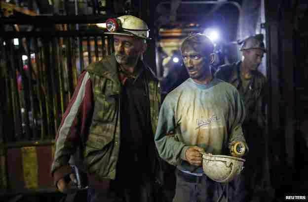
Five workers have died and 29 more were trapped underground for about 24 hours following an explosion and cave-in at the Raspotocje Coal Mine in Zenica in central Bosnia and Herzegovina on Thursday 4 September 2014. The incident occurred following an Earthquake that struck near Serajevo, which is though to have triggered the blast. 22 workers were able to escape from the mine at the time of the incident, leaving 34 bellow ground, rescue workers have now freed 29 of these, none of whom is thought to be seriously injured, but attempts to recover the remaining five men have been abandoned, and they are thought to have been buried in the collapse. This is the third explosion at the Raspotocje Coal Mine this year, though the first one in which there have been fatalities. Sixteen workers were injured in the two previous events, raising serious questions about safety at the mine.

Survivors emerging from the Raspotocje Coal Mine on Friday 5 September 2014. Reuters.

Coal is formed when buried organic material, principally wood, in heated and pressurized, forcing off hydrogen and oxygen (i.e. water) and leaving more-or-less pure carbon. Methane is formed by the decay of organic material within the coal. There is typically little pore-space within coal, but the methane can be trapped in a liquid form under pressure. Some countries have started to extract this gas as a fuel in its own right. When this pressure is released suddenly, as by mining activity, then the methane turns back to a gas, expanding rapidly causing, an explosion. This is a bit like the pressure being released on a carbonated drink; the term 'explosion' does not necessarily imply fire in this context, although as methane is flammable this is quite likely.

The western Balkan Peninsula forms the eastern margin of the Adriatic Plate, a piece of the African Plate that has broken away and is now wedged into the southern part of the Eurasian Plate. This is being squeezed by the impact of Africa into Europe from the south, which is pushing western Italy, which sits on the Eurasian Plate, to the east, and Greece and Turkey, which sit on the Aegean and Anatolian Plates, to the west. This squeezing leads to uplift around the margins of the Adriatic Plate, in the Apennine Mountains of central Italy and the mountain ranges of the west Balkan Peninsula. This is not a smooth process, and earthquakes in the region are fairly common.

Outline map showing the approximate positions of the Eurasian (EU), Adriatic (AD) and African (AF) Plates. Di Bucci & Mazzuli (2003).

See also...


The United States Geological Survey recorded a Magnitude 3.9 Earthquake at a depth of 20.5 km in...


Three men have died following an accident at an unlicensed mine near the village of Toptepe in Şırnak...


At least 232 miners are known to have died and it is feared the death toll will rise much higher following an explosion and fire at a coal mine operated by Soma Kömür İşletmeleri A.Ş., the country's...


Follow Sciency Thoughts on Facebook.

Sunday, 31 August 2014

Magnitude 3.9 Earthquake in western Bosnia and Herzegovina.

The United States Geological Survey recorded a Magnitude 3.9 Earthquake at a depth of 20.5 km in western Bosnia and Herzegovina, slightly after 8.15 pm local time (slightly after 6.15 pm GMT) on Saturday 30 August 2014. There are no reports of any damage or casualties associated with this event, but people have reported feeling it as far away as Split in Croatia.

The approximate location of the 30 August 2014 Bosnia and Herzegovina Earthquake. Google Maps.

The western Balkan Peninsula forms the eastern margin of the Adriatic Plate, a piece of the African Plate that has broken away and is now wedged into the southern part of the Eurasian Plate. This is being squeezed by the impact of Africa into Europe from the south, which is pushing western Italy, which sits on the Eurasian Plate, to the east, and Greece and Turkey, which sit on the Aegean and Anatolian Plates, to the west. This squeezing leads to uplift around the margins of the Adriatic Plate, in the Apennine Mountains of central Italy and the mountain ranges of the west Balkan Peninsula. This is not a smooth process, and earthquakes in the region are fairly common.

Outline map showing the approximate positions of the Eurasian (EU), Adriatic (AD) and African (AF) Plates. Di Bucci & Mazzuli (2003).

See also...


The United States Geological Survey recorded a Magnitude 4.9 Earthquake at a depth of 10 km in the Sarandë District of southern...


The United States Geological Survey recorded a Magnitude 4.6 Earthquake at a depth of 28.5 km, roughly 4 km to the south of the...


The United States Geological Survey recorded a Magnitude 4.9 Earthquake at a depth of 10 km, roughly 7 km east of the town of...


Follow Sciency Thoughts on Facebook.

Saturday, 15 June 2013

A new species of Pea Clam from the Miocene of Bosnia and Herzegovina.

Pea Clams, Sphaeriidae, are tiny freshwater bivalves, typically only a  few millimeters across. They are hermaphroditic, with eggs that are fertilized and grow within the mothers shell; newborn clams resemble adults, and are ready to breed almost immediately. This enables Pea Clams to rapidly colonize bodies of water with significant ecological - and palaeontological - consequences. Because of their small size, short life cycle and rapid reproduction, they rapidly build up large numbers of small, easily dissolved, calcium carbonate shells within bodies of water that they colonize. The addition of calcium carbonate will lower the pH of the water, enabling the colonization of waters by organisms unable to tolerate acid conditions, and slowing the dissolution of other mineralized tissues that fall into the water (e.g. other shells, bones, teeth), while at the same time aiding the formation of limestones in sediments deposited in the waterway, which greatly increases the chances of any organisms in the ecosystem of entering the fossil record.

In a paper published in the journal Fossil Record on 20 February 2013, Thomas NeubauerOleg Mandic and Mathias Harzhauser of the Department of Geology & Paleontology at the Naturhistorisches Museum Wien describe a new species of Pea Clam, discovered during a review of fossil Molluscs from Lake Gacko, a Middle Miocene lake that existed from about 15.8 to about 15.2 million years ago.

The new Clam is placed in the genus Pisidium, and given the specific name vukovici, after Boško Vuković, a geologist at the Rudnik i Termoelektrana Gacko, who enabled the study to be carried out at the site. Pisidium vukovici is a ~3 mm triangular clam, known only from a single horizon at the Gračanica site. It is thought to have lived approximately 15.83 million years ago.

Pisidium vukovici. Scale bar is 1 mm. Neubauer et al. (2013).


Follow Sciency Thoughts on Facebook.