Showing posts with label Dodecanese Islands. Show all posts

Saturday, 2 September 2017

Magnitude 4.9 Earthquake of the southeast coast of Rhodes.

The United States Geological Survey recorded a Magnitude 4.9 Earthquake at a depth of 77.6 km, about 11 km to the southeast of the island of Rhodes slightly before 7.50 pm local time (slightly before 4.50 pm GMT) on Friday 1 September 2017. No damage or injuries have been reported following this event, but people have reported feeling the event from Rhodes and neighbouring islands, as well as parts of the Anatolian (Turkish) mainland and as far away as Crete.
 
 The approximate location of the 1 September 2017 Rhodes Earthquake. USGS.
 
The island of Rhodes lies on the boundary between the Anatolian Plate, to the north, the Aegean Sea Plate (underlying the Peloponnese, Attica, The Cyclades Islands, Crete, the Dodecanese Islands and Turkey to the southeast of the Taurus Mountains) to the west and the African Plate to the south. Northern Greece and the north coast of Turkey lie on the Eurasian Plate. Both countries are highly prone to earthquakes because of this.
 
To the east the Arabian Plate  is being pushed north and west by the movement of the African Plate, further to the south. This leads to a zone of tectonic activity within the province, as the Arabian and Anatolian plates are pushed together, along the East Anatolian Fault, and past one-another, along the Dead Sea Transform.
 
This movement also leads to a zone of faulting along the northern part of Turkey, the North Anatolian Fault Zone, as the Anatolian Plate is pushed past the Eurasian Plate, which underlies the Black Sea and Crimean Peninsula  (transform faulting). This is not a simple process, as the two plates constantly stick together, then break apart as the pressure builds up, leading to Earthquakes, which can be some distance from the actual fault zone.
 
Simplified map of the plate movements of the eastern Mediterranean. Univeriteit Utrecht.


Witness accounts of Earthquakes can help geologists to understand these events, and the structures that cause them. The international non-profit organisation Earthquake Report is interested in hearing from people who may have felt this event; if you felt this quake then you can report it to Earthquake Report here.

See also...
http://sciencythoughts.blogspot.co.uk/2017/07/magnitude-67-earthquke-between-kos-and.htmlhttp://sciencythoughts.blogspot.co.uk/2017/05/magnitude-50-earthquake-in-izmir.html
http://sciencythoughts.blogspot.co.uk/2016/09/magnitude-52-earthquake-off-northwest.htmlhttp://sciencythoughts.blogspot.co.uk/2014/06/magnitude-50-off-southeast-coast-of.html
http://sciencythoughts.blogspot.co.uk/2014/05/magnitude-69-earthquake-beneath-north.htmlhttp://sciencythoughts.blogspot.co.uk/2013/09/magnitude-44-earthquake-of-south-coast.html
Follow Sciency Thoughts on Facebook.

Sunday, 23 July 2017

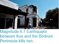
Magnitude 6.7 Earthquake between Kos and the Bodrum Peninsula kills two.

The United States Geological Survey reported a Magnitude 6.7 Earthquake at a depth of 10 km between the Greek island of Kos and the Bodrum Peninsula, Turkey, slightly after 1.30 am local time on Friday 21 July 2017 (slightly after 10.30 pm on Thursday 20 July, GMT). Two people have been reported dead on Kos following the event, both of whom have been identified as tourists, one being from Sweden and the other from Turkey, though they have not yet been named. About 430 people have been injured on Kos and Bodrum, with both having suffered extensive damage to buildings and infrastructure,and many tourists trapped in the area. A small tsunami was reported on Kos, and people have reported feeling the event as far away as Crete.

Damaged buildings on Kos following the 21 July 2017 Earthquake. Louisa Gouliamaki/Getty Images.

The island of Kos lies on the boundary between the Anatolian Plate, to the north, the Aegean Sea Plate (underlying the Peloponnese, Attica, The Cyclades Islands, Crete, the Dodecanese Islands and Turkey to the southeast of the Taurus Mountains) to the west and the African Plate to the south. Northern Greece and the north coast of Turkey lie on the Eurasian Plate. Both countries are highly prone to earthquakes because of this.

 The approximate location of the 21 July 2017 Kos Earthquake. USGS.

To the east the Arabian Plate  is being pushed north and west by the movement of the African Plate, further to the south. This leads to a zone of tectonic activity within the province, as the Arabian and Anatolian plates are pushed together, along the East Anatolian Fault, and past one-another, along the Dead Sea Transform.

 Damaged buildings on Kos following the 21 July 2017 Earthquake. Sky News.

This movement also leads to a zone of faulting along the northern part of Turkey, the North Anatolian Fault Zone, as the Anatolian Plate is pushed past the Eurasian Plate, which underlies the Black Sea and Crimean Peninsula  (transform faulting). This is not a simple process, as the two plates constantly stick together, then break apart as the pressure builds up, leading to Earthquakes, which can be some distance from the actual fault zone.

 Damage to boats at Bodrum following the 21 July 2017 Earthquake. Anadolu Agency.

The Aegean Sea Plate is moving southwest with regard to the Eurasian and Anatolian Plates, and being subducted beneath the African Plate to the south. Its margin with the Eurasian Plate is a divergent and a transform margin at different points. This is not a smooth process, with rocks tending to stick together, then being forced to move as the pressure builds up, typically in stops and starts that lead to Earthquakes.

 Simplified map of the plate movements of the eastern Mediterranean. Univeriteit Utrecht.

Witness accounts of Earthquakes can help geologists to understand these events, and the structures that cause them. The international non-profit organisation Earthquake Report is interested in hearing from people who may have felt this event; if you felt this quake then you can report it to Earthquake Report here. 

See also...

http://sciencythoughts.blogspot.co.uk/2017/05/magnitude-50-earthquake-in-izmir.htmlhttp://sciencythoughts.blogspot.co.uk/2016/09/magnitude-52-earthquake-off-northwest.html
http://sciencythoughts.blogspot.co.uk/2014/06/magnitude-50-off-southeast-coast-of.htmlhttp://sciencythoughts.blogspot.co.uk/2014/05/magnitude-69-earthquake-beneath-north.html
http://sciencythoughts.blogspot.co.uk/2014/05/hundreds-dead-following-explosion-at.htmlhttp://sciencythoughts.blogspot.co.uk/2013/10/turkish-miner-killed-by-underground-fire.html
Follow Sciency Thoughts on Facebook.

Wednesday, 28 September 2016

Magnitude 5.2 Earthquake off the northwest coast of Rhodes.

The United States Geological Survey recorded a Magnitude 5.2 Earthquake at a depth of 83.3 km, about 30 km to the northwest off the island of Rhodes slightly before midnight local time (slightly before 9.00 pm GMT) on Monday 27 September 2016. No damage or injuries have been reported following this event, but people have reported feeling the event from Rhodes and neighbouring islands, as well as much of the Anatolian (Turkish) mainland and as far away as Peleponesia in Greece.

The approximate location of the 23 September 2016 Rhodes Earthquake. Google.

The island of Rhodes lies on the boundary between the Anatolian Plate, to the north, the Aegean Sea Plate (underlying the Peloponnese, Attica, The Cyclades Islands, Crete, the Dodecanese Islands and Turkey to the southeast of the Taurus Mountains) to the west and the African Plate to the south. Northern Greece and the north coast of Turkey lie on the Eurasian Plate. Both countries are highly prone to earthquakes because of this.

To the east the Arabian Plate  is being pushed north and west by the movement of the African Plate, further to the south. This leads to a zone of tectonic activity within the province, as the Arabian and Anatolian plates are pushed together, along the East Anatolian Fault, and past one-another, along the Dead Sea Transform.

This movement also leads to a zone of faulting along the northern part of Turkey, the North Anatolian Fault Zone, as the Anatolian Plate is pushed past the Eurasian Plate, which underlies the Black Sea and Crimean Peninsula  (transform faulting). This is not a simple process, as the two plates constantly stick together, then break apart as the pressure builds up, leading to Earthquakes, which can be some distance from the actual fault zone.

The Aegean Sea Plate is moving southwest with regard to the Eurasian and Anatolian Plates, and being subducted beneath the African Plate to the south. Its margin with the Eurasian Plate is a divergent and a transform margin at different points. This is not a smooth process, with rocks tending to stick together, then being forced to move as the pressure builds up, typically in stops and starts that lead to Earthquakes.

 Simplified map of the plate movements of the eastern Mediterranean. Univeriteit Utrecht.

Witness accounts of Earthquakes can help geologists to understand these events, and the structures that cause them. The international non-profit organisation Earthquake Report is interested in hearing from people who may have felt this event; if you felt this quake then you can report it to Earthquake Report here.
See also...
http://sciencythoughts.blogspot.co.uk/2014/06/magnitude-45-earthquake-off-coast-of.htmlMagnitude 4.5 Earthquake off the coast of Hatay Province, southeast Turkey.               The United States Geological Survey recorded a Magnitude 4.5 Earthquake at a depth of 10 km, about 8 km offshore of the city of Ä°skenderun in Hatay...
http://sciencythoughts.blogspot.co.uk/2014/05/magnitude-69-earthquake-beneath-north.htmlMagnitude 6.9 Earthquake beneath the north Aegean Sea.                                                 The United States Geological Survey recorded a Magnitude 6.9 Earthquake at a depth of 10 km beneath the north Aegean Sea, close to the...
http://sciencythoughts.blogspot.co.uk/2013/10/magnitude-64-earthquake-off-west-coast.htmlMagnitude 6.4 Earthquake off the west coast of Crete.                                                       The United States Geological Survey recorded a Magnitude 6.4 Earthquake at a depth of 36.2 km roughly 30 km off the west coast of Crete...
Follow Sciency Thoughts on Facebook.
 

Friday, 13 June 2014

Magnitude 5.0 off the southeast coast of Karpathos, Greece.

The United States Geological Survey recorded a Magnitude 5.0 Earthquake at a depth of 65.3 km roughly 2 km off the southeast coast of the Dodecanese island of Karpathos, slightly before 2.35 am local time (slightly before 0.35 am GMT) on Friday 13 June 2014. People have reported feeling this quake on Karpathos and Rhodes, but not on nearby Crete. There are no reports of any damage or casualties.

The approximate location of the 13 June 2014 Karpathos Earthquake. Google Maps.

The Dodecanese Islands are located on the southern part of the Aegean Sea Plate, a small tectonic plate caught between the African Plate to the south, the Anatolian Plate to the east and the Eurasian Plate to the northwest. The Anatolian Plate is being pushed to the west by the northward movement of the Arabian Plate to the east, pushing the Aegean Plate south and west into collision with the northward moving African Plate. Part of the African Plate is being subducted beneath the Aegean Plate along the Hellenic Trench, to the south of the Dodecanese. This is not a smooth process, as the plates frequently stick together then break apart once the pressure has built up sufficiently, leading to (fairly frequent) Earthquakes.

See also...


The United States Geological Survey recorded a Magnitude 6.4 Earthquake at a depth of 36.2 km roughly 30 km off the west coast...


A Magnitude 4.4 Earthquake at a depth of 9.7 km occurred roughly 50 km to the south of the Greek island of Crete slightly before 5.00...


On Wednesday 12 September, slightly before 6.30 am, local time (slightly before 3.30 am GMT) the United States Geological Survey recorded a Magnitude 5.5 Earthquake 50 km south of western Crete, close to the island of Nísos Gávdos, at a depth of 27.4 km. No injuries or damage have been reported, but the quake is likely to have been felt across most of Crete.


Follow Sciency Thoughts on Facebook.