Showing posts with label Tsunami. Show all posts

Friday, 19 September 2025

Magnitude 7.8 Earthquake off the coast of the Kamchatka Peninsula, Russian Far East.

The United States Geological Survey recorded a Magnitude 7.8 Earthquake at a depth of 19.5 km off the east coast of the Kamchatka Peninsula in the Russian Far East slightly before 2.00 am local time on Friday 19 September 2025 (slightly before 7.00 pm on Thursday 18 September, GMT). Despite the size of this event, no casualties have been reported, although tsunami warnings were triggered across the Pacific. The event is thought to have been an aftershock of a Magnitude 8.8 Earthquake recorded off the coast of the Kamchatka Peninsula in July this year.

The approximate location of the 19 September 2025 Kamchatka Earthquake. USGS.

The Kamchatka Peninsula lies on the eastern edge of the Okhotsk Plate, close to its margin with the Pacific and North American Plates. The Pacific Plate is being subducted along the margin, and as it does so it passes under the southern part of the Kamchatka Peninsula. This is not a smooth process, the rocks of the two plates continuously stick together then, as the pressure builds up, break apart again, causing Earthquakes.

Simple diagram showing the subduction of the Pacific Plate beneath the Okhotsk Plate along the Kuril Trench. Auburn University.

Earthquakes along subductive margins are particularly prone to causing tsunamis, since these often occur when the overlying plate has stuck to the underlying plate, being pulled out of shape by its movement.. Eventually the pressure builds up to far and the overlying plate snaps back, causing an Earthquake and a tsunami.

Simplified graphic showing tsunami generation along a convergent margin. NASA/JPL/CalTech.

See also...

Friday, 1 August 2025

Magnitude 8.8 Earthquake off the Kamchatka Peninsula

The United States Geological Survey recorded a Magnitude 8.8 Earthquake at a depth of 20.7 km off the southeast coast of the Kamchatka Peninsula in the Russian Far East slightly before 11.25 am local time on Wednesday 30 July 2025 (slightly before 11.25 pm on Tuesday 29 July, GMT). A Magnitude of 8.8 makes this the sixth largest Earthquake ever recorded. Despite the size of this event, no casualties have been reported, although the port of Severo-Kurilsk was inundated by a 4 m wave, causing Russian authorities to evacuate the town, and tsunami warnings were triggered across the Pacific.

The approximate location of the 30 July 2025 Kamchatka Earthquake. USGS.

The Kamchatka Peninsula lies on the eastern edge of the Okhotsk Plate, close to its margin with the Pacific and North American Plates. The Pacific Plate is being subducted along the margin, and as it does so it passes under the southern part of the Kamchatka Peninsula. This is not a smooth process, the rocks of the two plates continuously stick together then, as the pressure builds up, break apart again, causing Earthquakes.

Simple diagram showing the subduction of the Pacific Plate beneath the Okhotsk Plate along the Kuril Trench. Auburn University.

Earthquakes along subductive margins are particularly prone to causing tsunamis, since these often occur when the overlying plate has stuck to the underlying plate, being pulled out of shape by its movement.. Eventually the pressure builds up to far and the overlying plate snaps back, causing an Earthquake and a tsunami.

Simplified graphic showing tsunami generation along a convergent margin.NASA/JPL/CalTech.

See also...

Sunday, 27 March 2022

Communities evacuated following eruptions on Mount Taal, Luzon Island.

About 1100 people have been evacuated from five communities around Lake Taal on Luzon Island, the Philippines, following an eruption on Mount Taal, an 311 m high volcano forming an island in the middle of the lake on Saturday 26 March 2022. Activity on the volcano began slightly after 7.20 am local time, with a series of phreatic explosions (explosions caused by hot magma or lava coming into contact with water), which produced a column of ash and steam about 1.5 km high, as well as a rain of hot mud and strong smell of sulphur dioxide which affected local communities. The Philippine Institute of Volcanology and Seismologyhas raised the alert level of the volcano following the eruption, and begun evacuations of communities around Lake Taal. 

 
A volcanic column above Mount Taal, Philippines, following an eruption on 26 March 2022. CNN.

While the volcano is in itself dangerous, much of the concern is that Earthquakes or eruptions around it could trigger a landslide into the lake, triggering a tsunami wave. Tsunamis occur when large volumes of water are displaced by geological events, such as landslips or Earthquakes, forming waves which spread out through the surrounding water. Like other waves, tsunamis are not necessarily obvious in deep, open waters, but when they reach shallow or enclosed waterways can be extremely dangerous. This is because a tsunami isn't just a wave above the normal water-level, it is pressure wave beneath the surface, which is amplified in the enclosed space. A tsunami reaching the shore is typically preceded and followed by rapidly shallowing water. Thus people in areas prone to tsunamis know to evacuate the coast rapidly if the tide apparently goes out rapidly, since this is likely to be followed by the tide coming in rapidly. This gives us the English term 'tidal wave' which is no longer used, since it is inaccurate; the tides are caused by the gravity of the sun and moon, tsunamis are nothing to do with the tide. The term 'tsunami' comes from Japan, where earthquakes, and therefore tsunamis, are common.

 
How a landslip can trigger a tsunami. University of California, Santa Cruz/BBC.

The geology of the Philippines is complex, with the majority of the islands located on the east of the Sunda Plate. To the east of this lies the Philippine Sea plate, which is being subducted beneath the Sunda Plate (a breakaway part of the Eurasian Plate); further east, in the Mariana Islands, the Pacific Plate is being subducted beneath the Philippine Sea Plate. This is not a smooth process, and the rocks of the tectonic plates frequently stick together before eventually being broken apart by the rising pressure, leading to Earthquakes in the process. Material from the subducting Philippine Plate is heated by the temperature of the Earth's interior, causing lighter minerals to melt and the resultant magma to rise through the overlying Sunda Plate, fuelling the volcanoes of the Philippines.

 
Subduction beneath the Philippines. Yves Descatoire/Singapore Earth Observatory.

See also...


Follow Sciency Thoughts on Facebook.

Follow Sciency Thoughts on Twitter.


Thursday, 20 January 2022

Tonga devastated by tsunami following eruption on the Hunga Ha'apai volcano

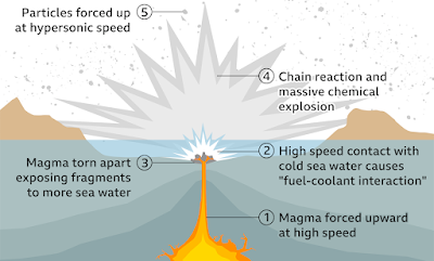
Three people, including a British citizen, have been confirmed dead and many more are missing following a tsunani that swept across the island nation of Tonga on Saturday 15 January 2022, following an eruption on the Hunga Ha'apai volcano. The volcano, which is usually underwater and is about 65 km to the north of the nation's capital, Nukuʻalofa, began erupting on 20 December 2021, producing a small island by the first week of January. However, on 15 January the centre of this island sank abruptly beneath the sea about two hours before the eruption. Vulcanologists have hypothesised that the eruption was caused by the collapse of a magma chamber, allowing seawater to come into contact with the hot magma, and triggering a phreatic explosion (rapid expansion of gas as a large volume of water turns to vapour more-or-less instantly).

 
Devastation on Tonga caused by the 15 January 2022 tsunami. Consulate of the Kingdom of Tonga.

Following the explosion a huge wave swept across the islands of Tonga, then out across the Pacific Ocean, reaching Australia and New Zealand in four hours, Japan in eight hours, California in ten hours and Alaska in eleven. Ths islands of Tonga suffered extensive damage, which destroyed much of the nation's communications infrastructure, with the extent of the destruction only becoming clear as ships from the New Zealand Navy reached the area several days later. As well as the obvious problems caused by the devastation of the nation's infrastructure, much of the area has been covered by sulphur-rich volcanic dust, which can be harmful if breathed in, and can react with fresh water to form sulphuric acid, threatening drinking water supplies. 

 
How a submarine phraetic explosion can cause a tsunami. BBC.

Hunga Ha’apai lies on the Tonga/Kermadec Ridge, and is fed by the subduction of the Pacific Plate beneath the Australian Plate along the Kermadec/Tonga Trench. As the Pacific Plate sinks into the Earth, it is warmed by the heat from the planets interior. This leads to partial melting of the Pacific Plate, with some of the melted material rising through the overlying Australian Plate as magma, fuelling the volcanos of the Kermadec/Tonga Ridge.

 
Diagram showing subduction along the Tonga Trench, and how this feeds the volcanoes of the Tonga Volcanic Arc. York University.

See also...


Follow Sciency Thoughts on Facebook.

Follow Sciency Thoughts on Twitter.


Sunday, 4 July 2021

Thousands of people evacuated after eruption on Mount Taal, the Philippines.

Thousands of people have been evacuated following an eruption on Mount Taal, on Luzon Island, the Philippines, on Thursday 11 July 2021. Activity on the 311 m high volcano began earlier in the week, when it began emitting large amounts of toxic sulphur dioxide gas, with the Philippine Institute of Volcanology and Seismology raising the alert level of the volcano following the eruption, which produced an ash column a kilometre high, and beginning evacuations of communities around Lake Taal, which is overlooked by the volcano. The vulcanologists are concerned by the sharp increase in seismic activity beneath the volcano, as such Earthquakes are often caused by the arrival of fresh magma, which may indicate that a volcano is about to undergo an eruptive episode.  

 
Eruption on Mount Taal, the Philippines, on 1 July 2021. AFP.

While the volcano is in itself dangerous, much of the concern is that Earthquakes or eruptions around it could trigger a landslide into the lake, triggering a tsunami wave. Tsunamis occur when large volumes of water are displaced by geological events, such as landslips or Earthquakes, forming waves which spread out through the surrounding water. Like other waves, tsunamis are not necessarily obvious in deep, open waters, but when they reach shallow or enclosed waterways can be extremely dangerous. This is because a tsunami isn't just a wave above the normal water-level, it is pressure wave beneath the surface, which is amplified in the enclosed space. A tsunami reaching the shore is typically preceded and followed by rapidly shallowing water. Thus people in areas prone to tsunamis know to evacuate the coast rapidly if the tide apparently goes out rapidly, since this is likely to be followed by the tide coming in rapidly. This gives us the English term 'tidal wave' which is no longer used, since it is inaccurate; the tides are caused by the gravity of the sun and moon, tsunamis are nothing to do with the tide. The term 'tsunami' comes from Japan, where earthquakes, and therefore tsunamis, are common.

 
How a landslip can trigger a tsunami. University of California, Santa Cruz/BBC.

The geology of the Philippines is complex, with the majority of the islands located on the east of the Sunda Plate. To the east of this lies the Philippine Sea plate, which is being subducted beneath the Sunda Plate (a breakaway part of the Eurasian Plate); further east, in the Mariana Islands, the Pacific Plate is being subducted beneath the Philippine Sea Plate. This is not a smooth process, and the rocks of the tectonic plates frequently stick together before eventually being broken apart by the rising pressure, leading to Earthquakes in the process. Material from the subducting Philippine Plate is heated by the temperature of the Earth's interior, causing lighter minerals to melt and the resultant magma to rise through the overlying Sunda Plate, fuelling the volcanoes of the Philippines.

 
Subduction beneath the Philippines. Yves Descatoire/Singapore Earth Observatory.

See also...


Follow Sciency Thoughts on Facebook.

Follow Sciency Thoughts on Twitter.


Friday, 5 March 2021

Magnitude 8.1 Earthquake in the Kermadec Islands.

The United States Geological Survey recorded a Magnitude 8.1 Earthquake at a depth of 19.4 km, in the Kermadec Islands, to the north of New Zealand, slightly before 6.30 am local time on Fridat 5 March 2021 (slighty before 7.30 pm on Thursday 4 March, GMT). The event was felt in the islands, and triggered a tsunami warning in New Zealand, where many people were evacuated from low lying areas on North Island, although in the the event, while some notable waves were observed, no damage or flooding was recorded.

The approximate location of the 5 March 2021 Kermadec Earthquake. USGS.

The event was part of a swarm of Earthquakes that has hit the area over the past 24 hours, with two focus points observed, one in the Kermadec Islands and one off the northeast coast of North Island. Two other Earthquakes with Magnitudes in excess of 7.0 have been recorded during this series of events, one in the Kermadec Islands, and one off the coast of North Island.

 
Earthquakes around New Zealand and the Kermadec Islands on 4-5 March 2021. The event indicated in red is the most recent. USGS.

The Kermadec Islands lie along the boundary between the Pacific and Australian Tectonic Plates. The Pacific Plate is being subducted beneath the Australian Plate along the Tonga Trench, which forms the boundary between these two plates, with the volcanic islands that make up the archipelago being formed as the subducting plate is melted by the heat of the planet's interior, so that lighter minerals rise up through the overlying plate as liquid magma, which fuels the volcanoes that build the islands. This subduction is not a smooth process, with the two plates constantly sticking together until the pressure generated by their movement builds up sufficiently to break them apart, causing a sudden forward jerk we experience as an Earthquake.
 
 
Diagram showing subduction along the Tonga Trench, and how this feeds the volcanoes of the Tonga Volcanic Arc. York University.
 
Further south, New Zealand is also located on the boundary beneath the Australian and Pacific Plates. Beneath the islands the Pacific Plate is being subducted beneath the Australian Plate. This causes a great deal of friction which causes Earthquakes where the boundary between the two plates is close to the surface; this is to the east of North Island, but onshore on South Island, where it can lead to strong Earthquakes. Technically such quakes also occur where the plate margin is deeper, but these are felt less strongly as the rocks between the boundary and the surface absorb much of the energy, making strong tremors much less frequent on North Island. As the Pacific Plate sinks deeper into the Earth it is partially melted by the friction and the heat of the planet's interior. Some of the melted material then rises through the overlying Australian Plate, fuelling the volcanoes of New Zealand.
 
The subduction zone beneath New Zealand, and how if fuels Earthquakes and volcanoes. Te Ara.
 
Earthquakes along subductive margins are particularly prone to causing tsunamis, since these often occur when the overlying plate has stuck to the underlying plate, being pulled out of shape by its movement.. Eventually the pressure builds up to far and the overlying plate snaps back, causing an Earthquake and a tsunami. 
 
 
Simplified graphic showing tsunami generation along a convergent margin.NASA/JPL/CalTech.
 
Witness reports of Earthquakes can help scientists to understand these events, and the underlying geologic processes that cause them. If you have felt an Earthquake in New Zealand then you can report it to the GeoNet project, which monitors quakes in New Zealand, here. 
 
See also...


Follow Sciency Thoughts on Facebook.
Follow Sciency Thoughts on Twitter.