Showing posts with label Enriquilo-Plantain Garden Fault Zone. Show all posts

Friday, 27 December 2024

Magnitude 6.1 earthquake off the south coast of Cuba.

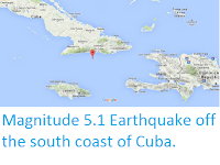
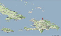
The National Seismological Research Service of Cuba recorded a Magnitude 6.1 Earthquake at a depth of 9 km, about 35 km off the south coast of Cuba at about 1.00 am local time (about 6.00 am GMT) on Monday 23 December 2024. The event was felt across eastern Cuba, Jamaica, and the Cayman Islands, and while there are no reports of any injuries, minor damage to buildings has been reported from across eastern Cuba, and several roads were blocked by landslides triggered by the Earthquake.

The approximate location of the 23 January 2024 Cuba Earthquake. USGS.

Cuba lies on the southern portion of the North American Plate, to the north of the Septentrional Fault Zone, which forms the boundary with the Gonâve Microplate, a small tectonic plate underlying northern Jamaica and most of the island of Hispaniola. The Gonâve Microplate is moving east relative to the North American Plate, pushed by the Mid-Cayman Spreading centre to the west of Jamaica.

To the south the Gonâve Microplate is separated from the Caribbean Plate by the Enriquilo-Plantain Garden Fault Zone, which runs across Southern Haiti and the Dominican Republic. To the west the fault runs through central Jamaica. The Caribbean Plate is rotating clockwise, effectively moving east relative to the Gonâve Microplate.

Plate movements and fault zones around the Gonâve Microplate. Mike Norton/Wikimedia Commons.

None of these movements are smooth, with rock formations at the boundaries of the plates constantly sticking together then breaking apart as the pressure from the plate movement builds up, triggering Earthquakes in the process.

See also...

Thursday, 30 January 2020

Magnitude 7.7 Earthquake between Cuba and Jamaica.

The United States Geological Survey recorded a Magnitude 7.7 Earthquake at a depth of 10 km roughly half way between the islands of Cuba and Jamaica in the Greater Antilles, at about 2.10 pm local time (about 7.10 pm GMT) on Tuesday 28 January 2020. Remarkably there are no reports of any damage or injuries associated with this event, however people have reported felling it across Jamaica, Cuba, the Cayman Islands, Haiti, Peurto Rica, Florida and western Mexico.

The approximate location of the 28 January 2020 Greater Antilles Earthquake. USGS.

Cuba lies on the southern portion of the North American Plate, to the north of the Septentrional Fault Zone, which forms the boundary with the Gonâve Microplate, a small tectonic plate underlying northern Jamaica and most of the island of Hispaniola. The Gonâve Microplate is moving east relative to the North American Plate, pushed by the Mid-Cayman Spreading centre to the west of Jamaica.

To the south the Gonâve Microplate is separated from the Caribbean Plate by the Enriquilo-Plantain Garden Fault Zone, which runs across Southern Haiti and the Dominican Republic. To the west the fault runs through central Jamaica. The Caribbean Plate is rotating clockwise, effectively moving east relative to the Gonâve Microplate.

Plate movements and fault zones around the Gonâve Microplate. Mike Norton/Wikimedia Commons.

None of these movements are smooth, with rock formations at the boundaries of the plates constantly sticking together then breaking apart as the pressure from the plate movement builds up, triggering Earthquakes in the process.

Witness accounts of Earthquakes can help geologists to understand these events, and the structures that cause them. The international non-profit organisation Earthquake Report is interested in hearing from people who may have felt this event; if you felt this quake then you can report it to Earthquake Report here.

See also...

https://sciencythoughts.blogspot.com/2019/02/meteorites-fall-on-cuban-town-after.htmlhttps://sciencythoughts.blogspot.com/2017/09/hurricane-irma-kills-forty-two-in.html
https://sciencythoughts.blogspot.com/2016/01/magnitude-51-earthquake-off-south-coast.htmlhttps://sciencythoughts.blogspot.com/2015/10/underground-fire-in-trinityville.html
https://sciencythoughts.blogspot.com/2015/08/tropical-storm-erika-kills-at-least-25.htmlhttps://sciencythoughts.blogspot.com/2014/01/magnitude-51-earthquake-on-north-coast.html


Follow Sciency Thoughts on Facebook.

Tuesday, 25 September 2018

Magnitude 5.2 Earthquake in Monte Cristi Province. Dominican Republic.

The United States Geological Survey recorded a Magnitude 5.2 Earthquake at a depth of 14.0 km roughly 3 km to the northwest of the town of Vila Elisa in Monte Cristi Province in the Dominican Republic, at about 1.45 am local time (about 5.45 am GMT) on Sunday 23 September 2018. There are some reports of minor damage associated with this event, and people have reported feeling it across most of the Dominican Republic, as well as parts of Haiti and Puerto RIco.

Damage to a house in Los Limones, Dominican Republic, following an Earthquake on 23 September 2018. Wilson Aracena/Diario Libre.

The Dominican Republic forms the eastern part of the island of La Hispaniola, in the Greater Antilles. The island has a complex geological structure, with parts of it lying on three different tectonic plates, and two plate margins running east-to-west across the island. The northernmost part of the island lies on the North American Plate. This is divided from the Gonâve Microplate by the Septentrional Fault Zone, which runs through Rio San Juan, along the north coast of the Dominican Republic and Haiti, then across the Windward Passage and along the south coast of Cuba. The Gonâve Microplate is moving east relative to the North American Plate, pushed by the Mid-Cayman Spreading centre to the west of Jamaica. To the south the Gonâve Microplate is separated from the Caribbean Plate by the Enriquilo-Plantain Garden Fault Zone, which runs across Southern Haiti and the Dominican Republic. To the west the fault runs through central Jamaica. The Caribbean Plate is rotating clockwise, effectively moving east relative to the Gonâve Microplate.

Plate movements and fault zones around the Gonâve Microplate. Mike Norton/Wikimedia Commons.

Witness accounts of Earthquakes can help geologists to understand these events, and the structures that cause them. The international non-profit organisation Earthquake Report is interested in hearing from people who may have felt this event; if you felt this quake then you can report it to Earthquake Report here 
 
See also...
 
http://sciencythoughts.blogspot.com/2017/09/fifty-nine-confirmed-deaths-as.html
https://sciencythoughts.blogspot.com/2018/06/magnitude-47-earthquake-in-monte-plata.html
 
http://sciencythoughts.blogspot.com/2017/02/magnitude-45-earthquake-in-sanchez.html
http://sciencythoughts.blogspot.com/2017/09/hurricane-irma-leaves-widespread.html
http://sciencythoughts.blogspot.com/2015/03/magnitude-47-earthquake-off-south-coast.html
http://sciencythoughts.blogspot.com/2015/08/tropical-storm-erika-kills-at-least-25.html

Follow Sciency Thoughts on Facebook.


Tuesday, 5 June 2018

Magnitude 4.7 Earthquake in Monte Plata Province, Dominican Republic.

The United States Geological Survey recorded a Magnitude 4.7 Earthquake at a depth of 83.3 km roughly 15 km to the east of the town of Gonzalo in Monte Plata Province in the Dominican Republic, slightly before 5.15 am local time (slightly before 9.15 am GMT) on Sunday 3 June 2018. There are no reports of any damage or injuries associated with this event, but people have reported feeling it across much of the Dominican Republic.
 
The approximate location of the 3 June 2018 Monte Plata Earthquake. USGS.
 
The Dominican Republic forms the eastern part of the island of La Hispaniola, in the Greater Antilles. The island has a complex geological structure, with parts of it lying on three different tectonic plates, and two plate margins running east-to-west across the island. The northernmost part of the island lies on the North American Plate. This is divided from the Gonâve Microplate by the Septentrional Fault Zone, which runs through Rio San Juan, along the north coast of the Dominican Republic and Haiti, then across the Windward Passage and along the south coast of Cuba. The Gonâve Microplate is moving east relative to the North American Plate, pushed by the Mid-Cayman Spreading centre to the west of Jamaica. To the south the Gonâve Microplate is separated from the Caribbean Plate by the Enriquilo-Plantain Garden Fault Zone, which runs across Southern Haiti and the Dominican Republic. To the west the fault runs through central Jamaica. The Caribbean Plate is rotating clockwise, effectively moving east relative to the Gonâve Microplate.
 
Plate movements and fault zones around the Gonâve Microplate. Mike Norton/Wikimedia Commons.
 
Witness accounts of Earthquakes can help geologists to understand these events, and the structures that cause them. The international non-profit organisation Earthquake Report is interested in hearing from people who may have felt this event; if you felt this quake then you can report it to Earthquake Report here 
 
See also...
 
http://sciencythoughts.blogspot.com/2017/09/fifty-nine-confirmed-deaths-as.htmlhttp://sciencythoughts.blogspot.com/2017/09/hurricane-irma-leaves-widespread.html
http://sciencythoughts.blogspot.com/2017/02/magnitude-45-earthquake-in-sanchez.htmlhttp://sciencythoughts.blogspot.com/2015/08/tropical-storm-erika-kills-at-least-25.html
http://sciencythoughts.blogspot.com/2015/03/magnitude-47-earthquake-off-south-coast.htmlhttp://sciencythoughts.blogspot.com/2015/01/magnitude-48-eathquake-in-southwest.html
Follow Sciency Thoughts on Facebook.

Monday, 27 February 2017

Magnitude 4.5 Earthquake in Sánchez Ramírez Province, Dominican Republic.

The United States Geological Survey recorded a Magnitude 4.5 Earthquake at a depth of 60.3 km roughly 5 km to the southwest of the town of Cevicos in Sánchez Ramírez Province in the Dominican Republic, slightly after 9.00 pm local time on Sunday 26 February 2017  (slightly after 1.00 am on Monday 27 February GMT). There are no reports of any damage or injuries associated with this event, but people have reported feeling it across much of Hispaniola (the island upon which Haiti and the Dominican Republic sit).
 

 The approximate location of the 26 February 2017 Dominican Republic Earthquake. USGS.

The Dominican Republic forms the eastern part of the island of La Hispaniola, in the Greater Antilles. The island has a complex geological structure, with parts of it lying on three different tectonic plates, and two plate margins running east-to-west across the island. The northernmost part of the island lies on the North American Plate. This is divided from the Gonâve Microplate by the Septentrional Fault Zone, which runs through Rio San Juan, along the north coast of the Dominican Republic and Haiti, then across the Windward Passage and along the south coast of Cuba. The Gonâve Microplate is moving east relative to the North American Plate, pushed by the Mid-Cayman Spreading centre to the west of Jamaica. To the south the Gonâve Microplate is separated from the Caribbean Plate by the Enriquilo-Plantain Garden Fault Zone, which runs across Southern Haiti and the Dominican Republic. To the west the fault runs through central Jamaica. The Caribbean Plate is rotating clockwise, effectively moving east relative to the Gonâve Microplate.

 Plate movements and fault zones around the Gonâve Microplate. Mike Norton/Wikimedia Commons.

See also... 

http://sciencythoughts.blogspot.co.uk/2016/10/hurricane-matthew-batters-haiti.htmlhttp://sciencythoughts.blogspot.co.uk/2015/08/tropical-storm-erika-kills-at-least-25.html
http://sciencythoughts.blogspot.co.uk/2015/03/magnitude-47-earthquake-off-south-coast.htmlhttp://sciencythoughts.blogspot.co.uk/2015/01/magnitude-48-eathquake-in-southwest.html
http://sciencythoughts.blogspot.co.uk/2014/06/magnitude-45-earthquake-on-north-coast.htmlhttp://sciencythoughts.blogspot.co.uk/2013/09/magnitude-31-earthquake-off-north-coast.html
Follow Sciency Thoughts on Facebook.

Monday, 18 January 2016

Magnitude 5.1 Earthquake off the south coast of Cuba.

The United States Geological Survey recorded a Magnitude 5.1 Earthquake at a depth of 10 km off the south coast of Cuba, slightly before 3.30 am local time (slightly before 8.30 m GMT) on SundaY 17 January 2016. There are no reports of any damage or injuries associated with this event, however people have reported felling it in the Guantanamo Bay area.

 The approximate location of the 17 January 2016 south Cuba Earthquake. Google Maps.

Cuba lies on the southern portion of the North American Plate, to the north of the Septentrional Fault Zone, which forms the boundary with the Gonâve Microplate, a small tectonic plate underlying northern Jamaica and most of the island of Hispaniola. The Gonâve Microplate is moving east relative to the North American Plate, pushed by the Mid-Cayman Spreading centre to the west of Jamaica.

To the south the Gonâve Microplate is separated from the Caribbean Plate by the Enriquilo-Plantain Garden Fault Zone, which runs across Southern Haiti and the Dominican Republic. To the west the fault runs through central Jamaica. The Caribbean Plate is rotating clockwise, effectively moving east relative to the Gonâve Microplate.

 Plate movements and fault zones around the Gonâve Microplate. Mike Norton/Wikimedia Commons.

None of these movements are smooth, with rock formations at the boundaries of the plates constantly sticking together then breaking apart as the pressure from the plate movement builds up, triggering Earthquakes in the process.

Witness accounts of Earthquakes can help geologists to understand these events, and the structures that cause them. The international non-profit organization Earthquake Report is interested in hearing from people who may have felt this event; if you felt this quake then you can report it to Earthquake Report here.

See also...

http://sciencythoughts.blogspot.co.uk/2015/03/magnitude-47-earthquake-off-south-coast.htmlMagnitude 4.7 Earthquake off the south coast of the Dominican Republic.                   The United States Geological Survey recorded a Magnitude 4.7 Earthquake at a depth of 20.8 km off the south coast of the...

http://sciencythoughts.blogspot.co.uk/2015/01/magnitude-48-eathquake-in-southwest.htmlMagnitude 4.8 Eathquake in the southwest Dominican Republic.                            The United States Geological Survey recorded a Magnitude 4.8 Earthquake at a depth of 10 km in San Cristóbal Province in the...
http://sciencythoughts.blogspot.co.uk/2014/06/magnitude-45-earthquake-on-north-coast.htmlMagnitude 4.5 Earthquake on the north coast of the Dominican Republic.                         The United States Geological Survey recorded a Magnitude 4.5 Earthquake at a depth of 10 km on the north coast of the Dominican Republic, slightly...
Follow Sciency Thoughts on Facebook. 


Saturday, 28 March 2015

Magnitude 4.7 Earthquake off the south coast of the Dominican Republic.

The United States Geological Survey recorded a Magnitude 4.7 Earthquake at a depth of 20.8 km off the south coast of the Dominican Republic, slightly before 2.15 pm local time (slightly before 6.15 pm GMT) on Friday 27 March 2015. There are no reports of any damage or injuries associated with this event, but people have reported feeling it across the central part of Hispaniola (the island upon which Haiti and the Dominican Republic sit).

The approximate location of the 27 March 2015 Dominican Republic Earthquake. Google Maps.

The Dominican Republic forms the eastern part of the island of La Hispaniola, in the Greater Antilles.  The island has a complex geological structure, with parts of it lying on three different tectonic plates, and two plate margins running east-to-west across the island. The northernmost part of the island lies on the North American Plate. This is divided from the Gonâve Microplate by the Septentrional Fault Zone, which runs through Rio San Juan, along the north coast of the Dominican Republic and Haiti, then across the Windward Passage and along the south coast of Cuba. The Gonâve Microplate is moving east relative to the North American Plate, pushed by the Mid-Cayman Spreading centre to the west of Jamaica. To the south the Gonâve Microplate is separated from the Caribbean Plate by the Enriquilo-Plantain Garden Fault Zone, which runs across Southern Haiti and the Dominican Republic. To the west the fault runs through central Jamaica. The Caribbean Plate is rotating clockwise, effectively moving east relative to the Gonâve Microplate.

Plate movements and fault zones around the Gonâve Microplate. Mike Norton/Wikimedia Commons.

See also...

The United States Geological Survey recorded a Magnitude 4.8 Earthquake at a depth of 10 km in San Cristóbal Province in the southwest of the...


The United States Geological Survey recorded a Magnitude 4.5 Earthquake at a depth of 10 km on the north coast of the Dominican Republic, slightly...


The United States Geological Survey recorded a Magnitude 3.4 Earthquake at a depth of 44 km under the southeast of the Dominican Republic, roughly 10 km...


Follow Sciency Thoughts on Facebook.