Showing posts with label Lincolnshire. Show all posts

Tuesday, 29 August 2023

Archaeologists uncover ritually buried Red Deer from Bronze Age England.

Archaeologists carrying out exploratory work ahead of the construction of a new water supply network in the east of England have uncovered what appears to be a pair of ritually buried Red Deer at Navenby in Lincolnshire, according to a press release issued by Anglian Water on 9 August 2023. The Deer, which are thought to have been buried about 4000 years ago, were accompanied by pottery associated with the Bell Beaker Culture, a Bronze Age European Culture with appeared about 4800 years ago in Iberia, and spread across Europe and parts of North Africa, reaching Britain about 4450 years ago. The Deer show no signs of butchery (the removal of meat for consumption, which leaves cut marks upon the bones), and were therefore presumably intact when buried, although it is possible that they were ritually sacrificed for some purpose.

Remnants of two Red Deer found in a Bronze Age burrial at Navenby in Lincolnshire, England. Anglian Water.

Other than the burred Deer, no further traces of Bronze Age activity were found at Navenby, although the archaeologists did uncover a small Iron Age settlement, comprising two roundhouses and five smaller structures, which may have been grain stores, as well as the burial of three cremated and one uncremated individuals, which may date from the Roman period.

See also...

Follow Sciency Thoughts on Facebook.

Follow Sciency Thoughts on Twitter.


Saturday, 24 October 2020

Magnitude 2.5 Earthquake in Lincolnshire, England.

The British Geological Survey recorded a Magnitude 2.5 Earthquake at a depth of 24 km, about 5 km to the east of the village of Scampton in north Lincolnshire, slightly before 2.50 am GMT on Wednesday 21 October 2020. This quake was not large enough to have caused any damage or injuries, but was felt across much of northern Lincolnshire.

 
The approximate location of the 21 October 2020 Lincolnshire Earthquakes. Google Maps.

Earthquakes become more common as you travel north and west in Great Britain, with the west coast of Scotland being the most quake-prone part of the island and the northwest of Wales being more prone  to quakes than the rest of Wales or most of England. However, while quakes in southern England are less frequent, they are often larger than events in the north, as tectonic pressures tend to build up for longer periods of time between events, so that when they occur more pressure is released.

Earthquakes become more common as you travel north and west in Great Britain, with the west coast of Scotland being the most quake-prone part of the island and the northwest of Wales being more prone  to quakes than the rest of Wales or most of England. However, while quakes in southern England are less frequent, they are often larger than events in the north, as tectonic pressures tend to build up for longer periods of time between events, so that when they occur more pressure is released.

Britain is being pushed to the east by the expansion of the Atlantic Ocean and to the north by the impact of Africa into Europe from the south. It is also affected by lesser areas of tectonic spreading beneath the North Sea, Rhine Valley and Bay of Biscay. Finally the country is subject to glacial rebound; until about 10 000 years ago much of the north of the country was covered by a thick layer of glacial ice (this is believed to have been thickest on the west coast of Scotland), pushing the rocks of the British lithosphere down into the underlying mantle. This ice is now gone, and the rocks are springing (slowly) back into their original position, causing the occasional Earthquake in the process.

 
(Top) Simplified diagram showing principle of glacial rebound. Wikipedia. (Bottom) Map showing the rate of glacial rebound in various parts of the UK. Note that some parts of England and Wales show negative values, these areas are being pushed down slightly by uplift in Scotland, as the entire landmass is quite rigid and acts a bit like a see-saw. Climate North East.

Witness accounts of Earthquakes can help geologists to understand these events, and the structures that cause them. If you felt this quake, or were in the area but did not (which is also useful information) then you can report it to the British Geological Survey here

See also...


Follow Sciency Thoughts on Facebook.

Follow Sciency Thoughts on Twitter.


Monday, 20 February 2017

Two Earthquakes in North Lincolnshire.

The British Geological Survey recorded a Magnitude 1.5 Earthquake at a depth of 16 km, about 10 km to the southeast of the town of Grimsby in north Lincolnshire, slightly after 5.30 am GMT on Friday 17 February 2017. This was followed by a second quake with a Magnitude of 1.3 at roughly the same location about 6.5 minutes later. These quakes were not large enough to have caused any damage or injuries, but may have been felt locally.
 
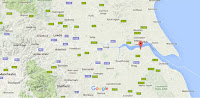
The approximate location of the 17 February 2017 Lincolnshire Earthquakes. Google Maps.
 
Earthquakes become more common as you travel north and west in Great Britain, with the west coast of Scotland being the most quake-prone part of the island and the northwest of Wales being more prone  to quakes than the rest of Wales or most of England. However, while quakes in southern England are less frequent, they are often larger than events in the north, as tectonic pressures tend to build up for longer periods of time between events, so that when they occur more pressure is released.

Earthquakes become more common as you travel north and west in Great Britain, with the west coast of Scotland being the most quake-prone part of the island and the northwest of Wales being more prone  to quakes than the rest of Wales or most of England. However, while quakes in southern England are less frequent, they are often larger than events in the north, as tectonic pressures tend to build up for longer periods of time between events, so that when they occur more pressure is released.
 
Britain is being pushed to the east by the expansion of the Atlantic Ocean and to the north by the impact of Africa into Europe from the south. It is also affected by lesser areas of tectonic spreading beneath the North Sea, Rhine Valley and Bay of Biscay. Finally the country is subject to glacial rebound; until about 10 000 years ago much of the north of the country was covered by a thick layer of glacial ice (this is believed to have been thickest on the west coast of Scotland), pushing the rocks of the British lithosphere down into the underlying mantle. This ice is now gone, and the rocks are springing (slowly) back into their original position, causing the occasional Earthquake in the process.
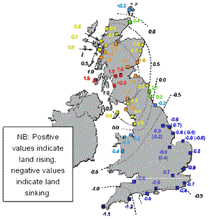
 
(Top) Simplified diagram showing principle of glacial rebound. Wikipedia. (Bottom) Map showing the rate of glacial rebound in various parts of the UK. Note that some parts of England and Wales show negative values, these areas are being pushed down slightly by uplift in Scotland, as the entire landmass is quite rigid and acts a bit like a see-saw. Climate North East.
 
Witness accounts of Earthquakes can help geologists to understand these events, and the structures that cause them. If you felt the first quake, or were in the area but did not (which is also useful information) then you can report it to the British Geological Survey here, and if you felt the second quake (or did not) then you can report it here.
 
See also...
 
http://sciencythoughts.blogspot.co.uk/2016/05/magnitude-13-earthquake-in-lincolnshire.html
http://sciencythoughts.blogspot.co.uk/2017/01/magnitude-38-earthquake-beneath.html
 
http://sciencythoughts.blogspot.co.uk/2016/02/nottinghamshire-sinkhole-traps-car.html
http://sciencythoughts.blogspot.co.uk/2016/04/magnitude-14-earthquake-near-barton.html
http://sciencythoughts.blogspot.co.uk/2015/09/magnitude-28-earthquake-in-rutland.html
http://sciencythoughts.blogspot.co.uk/2015/11/series-of-earthquakes-in-north.html

Follow Sciency Thoughts on Facebook.

Friday, 6 May 2016

Magnitude 1.3 Earthquake in Lincolnshire, England.

The British Geological Survey recorded a Magnitude 1.3 Earthquake at a depth of 7 km, about 10 km to the southwest of the town of Lincoln, slightly after 9.00 pm British Summertime (slightly after 8.00 pm GMT) on Wednesday 4 May 2016. This quake is not large enough to have caused any damage or injuries, but may have been felt locally.

The approximate location of the 4 May 2016 Lincolnshire Earthquake. Google Maps.

Earthquakes become more common as you travel north and west in Great Britain, with the west coast of Scotland being the most quake-prone part of the island and the northwest of Wales being more prone  to quakes than the rest of Wales or most of England. However, while quakes in southern England are less frequent, they are often larger than events in the north, as tectonic presures tend to build up for longer periods of time between events, so that when they occur more pressure is released.

The precise cause of Earthquakes in the UK can be hard to determine; the country is not close to any obvious single cause of such activity such as a plate margin, but is subject to tectonic pressures from several different sources, with most quakes probably being the result of the interplay between these forces.

Britain is being pushed to the east by the expansion of the Atlantic Ocean and to the north by the impact of Africa into Europe from the south. It is also affected by lesser areas of tectonic spreading beneath the North Sea, Rhine Valley and Bay of Biscay. Finally the country is subject to glacial rebound; until about 10 000 years ago much of the north of the country was covered by a thick layer of glacial ice (this is believed to have been thickest on the west coast of Scotland), pushing the rocks of the British lithosphere down into the underlying mantle. This ice is now gone, and the rocks are springing (slowly) back into their original position, causing the occasional Earthquake in the process.
 

  (Top) Simplified diagram showing principle of glacial rebound. Wikipedia. (Bottom) Map showing the rate of glacial rebound in various parts of the UK. Note that some parts of England and Wales show negative values, these areas are being pushed down slightly by uplift in Scotland, as the entire landmass is quite rigid and acts a bit like a see-saw. Climate North East.

Witness accounts of Earthquakes can help geologists to understand these events, and the structures that cause them. If you felt this quake, or were in the area but did not (which is also useful information) then you can report it to the British Geological Survey here 

See also...

http://sciencythoughts.blogspot.co.uk/2016/04/magnitude-14-earthquake-near-barton.htmlMagnitude 1.4 Earthquake near Barton Upon Humber in Lincolnshire, England.        The British Geological Survey recorded a Magnitude 1.4 Earthquake at a depth of 18 km, about 1 km to the east...
http://sciencythoughts.blogspot.co.uk/2016/02/nottinghamshire-sinkhole-traps-car.htmlNottinghamshire sinkhole traps car.               A woman was forced to abandon her car after it became trapped in a sinkhole in the village of Epperstone in eastern Notinghamshire, England, on Sunday 21 February 2016. Sally Hall was driving through what she thought was a large puddle caused...
http://sciencythoughts.blogspot.co.uk/2015/11/series-of-earthquakes-in-north.htmlSeries of Earthquakes in north Nottinghamshire, England.                 The British Geological Survey has recorded a series of Earthquakes in northern Nottingham, England. The...
Follow Sciency Thoughts on Facebook.