Showing posts with label Meers Fault System. Show all posts

Saturday, 10 September 2016

Magnitude 3.8 Earthquake beneath Spencer, Oklahoma.

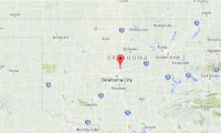
The United States Geological Survey recorded a Magnitude 3.8 Earthquake at a depth of 5.0 km beneth the city of Spencer in Oklahoma County, Oklahoma, slightly after 9.05 pm local time on Thursday 8 September 2016 (slightly after 2.05 am on Friday 9 September GMT). There are no reports of any damage or injuries associated with this Earthquake, but it was felt across much of Oklahoma as well as parts of Arkansas and Texas.

 The approximate location of the 8 September 2016 Spencer Earthquake. Google.

Oklahoma is naturally prone to Earthquakes, particularly in the southwest of the state, near the Meers Fault Zone, but since 2009 has suffered a sharp increase in the number of small quakes in the central and northeast parts of the state. While most of these quakes have been quite small, a few have been large enough to potentially cause problems, and any unexplained increase in seismic activity is a cause for concern.

In a paper published in the journal Geology on 26 March 2013, a team of geologists led by Katie Keranen of the ConocoPhillips School of Geology and Geophysics at the University of Oklahoma linked one of the largest of these quakes, a Magnitude 5.7 event in November 2011 which caused damage locally and was felt across 17 states, to the practice of pumping liquids (usually brine) into injection wells, which is common in the hydrocarbons industry and used to displace oil or gas, which can then be extracted from nearby extraction wells (where this is done in bursts at pressure to intentionally break up rock it is called hydraulic fracturing, or fracking). Significantly they suggested that the practice could lead to quakes years or even decades after the actual injection.

Witness accounts of quakes can help geologists to understand these events and the rock structures that cause them. If you felt this quake (or if you were in the area but did not, which is also useful information) you can report it to the USGS here.

See also...

http://sciencythoughts.blogspot.co.uk/2016/09/magnitude-56-earthquake-in-pawnee.htmlMagnitude 5.6 Earthquake in Pawnee County, Oklahoma.                               The United States Geological Survey recorded a Magnitude 5.6 Earthquake at a depth of 6.6 km 14 to the northwest of Pawnee City in Pawnee County County, Oklahoma, slightly after 7.00 am local time (slightly...
   
http://sciencythoughts.blogspot.co.uk/2016/03/magnitude-42-earthquake-in-logan-county.htmlMagnitude 4.2 Earthquake in Logan County, Oklahoma.                                             The United States Geological Survey recorded a Magnitude 4.2 Earthquake at a depth of 4 km slightly...
http://sciencythoughts.blogspot.co.uk/2015/11/magnitude-43-earthquake-in-woods-county.htmlMagnitude 4.3 Earthquake in Woods County, Oklahoma.                                             The United States Geological Survey recorded a Magnitude 4.3 Earthquake at a depth of 5 km...
Follow Sciency Thoughts on Facebook.

Saturday, 3 September 2016

Magnitude 5.6 Earthquake in Pawnee County, Oklahoma.

The United States Geological Survey recorded a Magnitude 5.6 Earthquake at a depth of 6.6 km 14 to the northwest of Pawnee City in Pawnee County County, Oklahoma, slightly after 7.00 am local time (slightly after noon GMT) on Saturday 3 September 2016. There are no reports of any damage or injuries associated with this Earthquake, but it was felt across a large area the central United States, from New Mexico, Texas and Louisiana in the south to South Dakota, Minesota and Wisconsin in the north.

The approximate location of the 3 September 2016 Pawnee Earthquake. Google.

Oklahoma is naturally prone to Earthquakes, particularly in the southwest of the state, near the Meers Fault Zone, but since 2009 has suffered a sharp increase in the number of small quakes in the central and northeast parts of the state. While most of these quakes have been quite small, a few have been large enough to potentially cause problems, and any unexplained increase in seismic activity is a cause for concern. 

In a paper published in the journal Geology on 26 March 2013, a team of geologists led by Katie Keranen of the ConocoPhillips School of Geology and Geophysics at the University of Oklahoma linked one of the largest of these quakes, a Magnitude 5.7 event in November 2011 which caused damage locally and was felt across 17 states, to the practice of pumping liquids (usually brine) into injection wells, which is common in the hydrocarbons industry and used to displace oil or gas, which can then be extracted from nearby extraction wells (where this is done in bursts at pressure to intentionally break up rock it is called hydraulic fracturing, or fracking). Significantly they suggested that the practice could lead to quakes years or even decades after the actual injection.

Witness accounts of quakes can help geologists to understand these events and the rock structures that cause them. If you felt this quake (or if you were in the area but did not, which is also useful information) you can report it to the USGS here.

See also...

http://sciencythoughts.blogspot.co.uk/2016/03/magnitude-42-earthquake-in-logan-county.htmlMagnitude 4.2 Earthquake in Logan County, Oklahoma.                                             The United States Geological Survey recorded a Magnitude 4.2 Earthquake at a depth of 4 km slightly...
http://sciencythoughts.blogspot.co.uk/2015/11/magnitude-43-earthquake-in-woods-county.htmlMagnitude 4.3 Earthquake in Woods County, Oklahoma.                                             The United States Geological Survey recorded a Magnitude 4.3 Earthquake at a depth of 5 km...
http://sciencythoughts.blogspot.co.uk/2015/08/magnitude-37-earthquake-in-oklahoma.htmlMagnitude 3.7 Earthquake in Oklahoma County, Oklahoma.                             The United States Geological Survey recorded a Magnitude 3.7 Earthquake at a depth of 5 km in northern Noble County, Oklahoma, before 7.20...
Follow Sciency Thoughts on Facebook.

Monday, 16 November 2015

Magnitude 4.3 Earthquake in Woods County, Oklahoma.

The United States Geological Survey recorded a Magnitude 4.3 Earthquake at a depth of 5 km in southern Woods County, Oklahoma, at about 3.45 am am local time (at about 9.45 am GMT) on Sunday 15 October 2015. There is little danger of any damage or injuries being caused by an Earthquake of this Magnitude, but people have reported feeling it across much of northern Oklahoma and southern Kansas.

The approximate location of the 15 November 2015 Woods County Earthquake. Google Maps.


Oklahoma is naturally prone to Earthquakes, particularly in the southwest of the state, near the Meers Fault Zone, but since 2009 has suffered a sharp increase in the number of small quakes in the central and northeast parts of the state. While most of these quakes have been quite small, a few have been large enough to potentially cause problems, and any unexplained increase in seismic activity is a cause for concern. 


In a paper published in the journal Geology on 26 March 2013, a team of geologists led by Katie Keranen of the ConocoPhillips School of Geology and Geophysics at the University of Oklahoma linked one of the largest of these quakes, a Magnitude 5.7 event in November 2011 which caused damage locally and was felt across 17 states, to the practice of pumping liquids (usually brine) into injection wells, which is common in the hydrocarbons industry and used to displace oil or gas, which can then be extracted from nearby extraction wells (where this is done in bursts at pressure to intentionally break up rock it is called hydraulic fracturing, or fracking). Significantly they suggested that the practice could lead to quakes years or even decades after the actual injection.
 
Witness accounts of Earthquakes can help geologists to understand these events, and the structures that cause them. The international non-profit organization Earthquake Report is interested in hearing from people who may have felt this event; if you felt this quake then you can report it to Earthquake Report here.
 
See also...

http://sciencythoughts.blogspot.co.uk/2015/08/magnitude-37-earthquake-in-oklahoma.htmlMagnitude 3.7 Earthquake in Oklahoma County, Oklahoma.                                     The United States Geological Survey recorded a Magnitude 3.7 Earthquake at a depth of 5 km in northern Noble County, Oklahoma, before 7.20 am local..
One man has died and at least 24 other have been injured following an outbreak of tornadoes across Oklahoma and parts of Arkansas on Thursday 26 March 2015. The dead man is reported to have died while trying to aid his injured father at the River...
 
 
The United States Geological Survey recorded a Magnitude 4.0 Earthquake at a depth of 5 km in eastern Noble County, Oklahoma, before 5.10 am local time...
 
 
Follow Sciency Thoughts on Facebook.


Sunday, 30 August 2015

Magnitude 3.7 Earthquake in Oklahoma County, Oklahoma.

The United States Geological Survey recorded a Magnitude 3.7 Earthquake at a depth of 5 km in northern Noble County, Oklahoma, before 7.20 am local time (slightly before 0.20 am GMT) on Sunday 30 August 2015. There is little danger of any damage or injuries being caused by an Earthquake of this Magnitude, but people have reported feeling it in the city of Edmond.

The approximate location of the 30 August 2015 Oklahoma County Earthquake. Google Maps.

Oklahoma is naturally prone to Earthquakes, particularly in the southwest of the state, near the Meers Fault Zone, but since 2009 has suffered a sharp increase in the number of small quakes in the central and northeast parts of the state. While most of these quakes have been quite small, a few have been large enough to potentially cause problems, and any unexplained increase in seismic activity is a cause for concern. 

In a paper published in the journal Geology on 26 March 2013, a team of geologists led by Katie Keranen of the ConocoPhillips School of Geology and Geophysics at the University of Oklahoma linked one of the largest of these quakes, a Magnitude 5.7 event in November 2011 which caused damage locally and was felt across 17 states, to the practice of pumping liquids (usually brine) into injection wells, which is common in the hydrocarbons industry and used to displace oil or gas, which can then be extracted from nearby extraction wells (where this is done in bursts at pressure to intentionally break up rock it is called hydraulic fracturing, or fracking). Significantly they suggested that the practice could lead to quakes years or even decades after the actual injection.

Witness accounts of Earthquakes can help geologists to understand these events, and the structures that cause them. The international non-profit organization Earthquake Report is interested in hearing from people who may have felt this event; if you felt this quake then you can report it to Earthquake Report here.

See also...

One man has died and at least 24 other have been injured following an outbreak of tornadoes across Oklahoma and parts of Arkansas on Thursday 26 March 2015. The dead man is reported to have died while trying to aid his injured father at the River...


The United States Geological Survey recorded a Magnitude 4.0 Earthquake at a depth of 5 km in eastern Noble County, Oklahoma, before 5.10 am local time...


The United States Geological Survey recorded a Magnitude 3.3 Earthquake at a depth of 5 km in northern Grant County, Oklahoma, slightly after 7.10 pm...


Follow Sciency Thoughts on Facebook.

Tuesday, 24 December 2013

Two Magnitude 3.3 Earthquakes in Parker County, Texas.

The United States Geological Survey recorded a Magnitude 3.3 Earthquake at a depth of 5 km, in northeastern Parker County, Texas, roughly 30 km to the northwest of Forth Worth, slightly after 11.30 am local time (slightly after 5.30 pm GMT) on Sunday 22 December 2013. This was followed by a second quake with the same Magnitude, at a depth of 6.5 km and roughly 1 km to the north, slightly after 7.10 am local time (slightly after 1.10 pm GMT) on Monday 23 December. There are no reports of any damage or casualties relating to these events, though both were felt throughout the Fort Worth and Dallas areas.

The approximate locations of the 22 & 23 December 2013 Parker County Earthquakes. Google Maps.

Northern Texas has suffered a string of Earthquakes over the last two months, which some residents have linked to injection well drilling, (pumping liquids into oil or gas bearing rocks to displace the hydrocarbons and make it easier to extract), a process that has been linked to increased seismic activity in parts of the US and Europe. The Railroad Commission of Texas, which has responsibility for regulating the oil and gas industries in Texas, and pointing out that many of these quakes have occurred in areas where injection well drilling does not occur.

Northern Texas is affected by seismic activity on the Balcones, Mexia, Talco and Meers Fault systems, although not all of the recent quakes have been close to any of these structures, and any increase in seismic activity is likely to be viewed with concern by people living in the area. Several observers have noted that the much of the recent activity has been associated with the Barnett Shale, which underlies the Dallas and Fort Worth area, and which has become a focus for the natural gas industry in recent years. The Barnett Shale is considered to be a 'tight' reservoir (i.e. it does not give up its gas easily) and has largely been worked by the hydraulic fracturing (fracking) method, a form of injection well drilling that involves blasting liquids into a hydrocarbon-bearing formation at high pressure in order to break up the rock structures and release the gas, a process which has caused particular concern to environmentalists, who link the methodology not only to Earthquakes, but also to pollution of aquifers and excess use of water (a major concern in dry areas such as Texas).

The Texas Railroad Commissioner, David Porter, is to address a public meeting on the subject at Azle High School in Azle, in Tarrant County, Texas, at 5.00-7.00 pm on 2 January 2014, where local residents are likely to raise concerns. The Mayor of Azle, Alan Brundrett, has asked the commission to look specifically into the causes of Earthquakes affecting the town.

Witness accounts of quakes can help geologists to understand these events and the rock structures that cause them. If you felt these quakes (or if you were in the area but did not, which is also useful information) you can report it to the USGS here (for the 22 December event) or here (for the 23 December event).


Follow Sciency Thoughts on Facebook.

Wednesday, 25 September 2013

Magnitude 3.2 Earthquake in Love County, south Oklahoma.

The United States Geological Survey recorded a Magnitude 3.2 Earthquake at a depth of 5 km, in Love County in south Oklahoma, roughly 8 km to the southwest of Overbrook, at approximately 6.40 am local time (approximately 11.40 am GMT) on Monday 23 September 2013. This is a moderate Earthquake, unlikely to have caused any damage or injuries, but felt as far away as Sherman, 70 km to the southeast.

The approximate location of the 23 September 2013 Love County Earthquake. Google Maps.

The quake appears to have occurred on an area very close to the Muenster-Waurika Fault, a part of the Meers Fault System. Southern Oklahoma is being compressed in an east-west direction by the expansion of the Atlantic Ocean to the east and subduction along the North American Plate margin to the west. This causes slip-strike faulting along the Meers Fault, with deposits to the west being forced up over rocks to the east. This does not happen smoothly, and the uplifting rocks have been split into a number of fault-bounded blocks, which move separately of each-other vertically. The Muenster-Waurika Fault is one of these faults.

Representation of the Meers Fault System in southern Oklahoma, showing the position of the Muenster-Waurika Fault. Gay (2003).


Follow Sciency Thoughts on Facebook.