Showing posts with label Tibet. Show all posts

Monday, 31 August 2026

More than 900 people have now been confirmed dead and over 3000 are still missing following a glacier collapse on the Nepal-Tibet border.

More than 800 people are now known to have died and more than 3000 are still missing following a glacier collapse on the border between Nepal and Tibet on Wednesday 26 August 2026. The incident was first recorded as a Magnitude 4.4 Earthquake by the United States Geological Survey at 2.52 am GMT, which is 8.37 am in Nepal and 10.52 am in Tibet (Tibet has been part of China since the 1950s, and China uses a single time-zone for all its territory, leading to a two-and-a-half hour time gap between Tibet and Nepal, despite their having a similar longitude), a figure which was revised to a Magnitude 5.2 event shortly after. Seven minutes after this a flash flood and debris flow hit the Gyirong Port border crossing between Nepal and Tibet, before passing along the Lhende Khola River Valley in Nepal and into the Trishuli River system.

CCTV footage of a flash flood and debris flow hit the Gyirong Port border crossing between Nepal and Tibet on Wednesday 26 August 2026. Hong Kong Standard.

This event was initially interpreted as an Earthquake-induced glacier collapse, probably caused by a glacier shattering and releasing a melt-lake which had built up behind it. Such events are the most common form of glacier collapse, and are particularly associated with warming global temperatures. Essentially, glaciers begin to melt behind their leading edge, with the amount of ice in front of the growing lake slowly decreasing till the whole edifice collapses. However satellite images taken in the days before the collapse revealed no such lake, and it is now thought that a chunk of glacier with an area of about 200 000 m², and a volume of 1-2 million m³, broke off a glacier at an altitude of between 5200  m and 5400 m above sealevel, then dropped vertically about 1200 m into the valley below. This impact caused the event which the United States Geological Survey interpreted as an Earthquake.

CCTV footage of a debris flow hitting the Gyrong Port Border Crossing on Wednesday 26 August 2026. Resonoud News (响亮新闻)/Wikimedia Commons.

Approximately seven minutes after this initial collapse, the Gyirong Port Border Crossing was hit by a flood and debris flow 80 m high, travelling at approximately 180 km per hour (50 m per second). This remarkable velocity was driven largely by the steep nature of the high mountain valleys, with the Gyirong Port border crossing being approximately 3000 m lower than the initial impact point of the falling glacier. The debris flow continued down the valley for approximately 100 km, sweeping away 41 bridges and 42 km of road, as well as the Gyirong Port border crossing in Tibet and the corresponding Rasuwagadhi Customs Office in Nepal, as well as numerous homes and other buildings, and causing significant damage to six hydroelectric projects in Nepal. Bodies of victims of this flood event have been found as far away as Uttar Pradesh in northern India, more than 250 km from the initial glacier collapse event.

The remains of a bridge in Nepal swept away by the 26 August 2026 floods. Ritesh Shukla/Getty Images.

Glacier collapses are a part of the natural cycle of events within the Himalayas. The mountains here are not static, but are actively growing as the northward movement of the Indian Plate pushes up the overlying Eurasian plate. This means that glaciers which sit upon these mountains are slowly raised to ever higher altitudes, while at the same time becoming ever more steeply inclined. Eventually, this situation becomes unstable, and gravity overcomes the ability of the ice to stick to the underlying rocks, causing sections of glacier to collapse down the sides of the mountains.

Block diagram showing how the impact of the Indian Plate into Eurasia is causing uplift on the Tibetan Plateau. Jayne Doucette/Woods Hole Oceanographic Institution.

This situation is made significantly worse by rising global temperatures, with the Himalayan region warming at twice the global average, which lead to higher rates of melting on glaciers in the Himalayas. The problem here is not just that the ice melts, but that when it does the water tends to percolate downward through any cracks or holes in the glacier surface, eventually pooling on the underside of the glacier. This creates a layer of liquid water over which the glacier can flow, which is the natural way in which glaciers move in lowland areas, but can lead to catastrophic consequences on high, steeply inclined glaciers.

This warming does not just threaten glaciers in these regions; many of the highest mountains are effectively rubble piles held together by ice and frozen soil (permafrost). As the Himalayas warm this ice can thaw, leading to parts of mountains breaking away, leading to more and larger landslides and rockfalls in an area where these are already a major threat to both lives and infrastructure. 

Rescue efforts following the 26 August event have been greatly impacted by the loss of roads and bridges, as well as the large amounts of mud and silt left behind by the floods. Rescue workers have often had to wade through deep mud to reach communities cut off by the floods, with other communities only accessible by helicopter. 

Floodwaters and debris passing through a community in Nepal on Wednesday 26 August 2026. Safal Prakash Shrestha/JNA Press/ZUMA Press/Shutterstock.

Concerns were raised about a second flood hitting the area on Thursday 27 August, after Chinese authorities discovered a barrier lake which had formed behind debris deposited at the confluence of the Chhochen Khola and Purepu Tsangpo rivers in Tibet. At the time, there was an estimated three million cubic metres of water in this lake, which had begun to overtop the barrier, leading to fears of an imminent collapse. However, this lake subsequently drained away naturally without Human interference, and had largely disappeared by Sunday 30 August. 

See also...

Tuesday, 7 January 2025

Magnitude 6.8 earthquake in southern Tibet kills at least 126 people.

The China Earthquake Networks Center recorded a Magnitude 6.8 Earthquake at a depth of 10 km beneath Tingri County in southern Tibet, close to Mount Everest and the border with Tibet at about 9.05 am local time on Tuesday 7 January 2025 (about 1.05 am, GMT). The Earthquake was felt across southern Tibet, eastern Nepal, western Bhutan, northeastern India and northern Bangladesh. More than 150 aftershocks have been recorded since the original event.

The approximate location of the 7 January 2025 Tibet Earthquake. USGS.

At the time of writing rescue workers have reported 126 deaths and 188 people injured in Tibet and another five injuries in Nepal. However, the number of casualties is likely to rise significantly, as the population in the area around the epicentre of the Earthquake largely live in small, remote villages, largely cut off from the outside world, and which are subsequently difficult for rescue workers to reach. To make matters worse, daytime temperatures in the area average -8°C at this time of year, falling to -18°C at night. More than a thousand homes have been damaged or destroyed in areas that rescue workers have managed to reach, so is likely that in other areas people may have lost  their homes or be trapped beneath debris, vulnerable to the cold.

Rescue workers in Tingri County, Tibet, following a Magnitude 6.8 Earthquake on Tuesday 7 January 2024. Xinhua/AP.

Earthquake activity in the area is caused by the uplift of the Tibetan Plateau, due to the impact of India into Eurasia to the south. he Indian Plate is moving northwards at a rate of 5 cm per year, causing it to impact into Eurasia, which is also moving northward, but only at a rate of 2 cm per year. The collision of the Indian and Eurasian plates has led to the formation of the Himalayan Mountains, the Tibetan Plateau, and the mountains of southwest China, Central Asia and the Hindu Kush.

Block diagram showing how the impact of the Indian Plate into Eurasia is causing uplift on the Tibetan Plateau. Jayne Doucette/Woods Hole Oceanographic Institution.

Much of Tibet and neighbouring areas of Central Asia and the Himalayas, are prone to Earthquakes caused by the impact of the Indian Plate into Eurasia from the south. When two tectonic plates collide in this way and one or both are oceanic then one will be subducted beneath the other (if one of the plates is continental then the other will be subducted), but if both plates are continental then subduction will not fully occur, but instead the plates will crumple, leading to folding and uplift (and quite a lot of Earthquakes). The collision of the Indian and Eurasian plates has lead to the formation of the Himalayan Mountains, the Tibetan Plateau, and the mountains of southwest China, Central Asia and the Hindu Kush.

The movement of India into Eurasia over the last 71 million years. USGS.

See also...

Thursday, 13 July 2023

Selaginella densiciliata: A new species of Spikemoss from Medog County, Tibet.

The Lycophytes were one of the first groups of Vascular Plants to emerge in the Silurian, and remained one of the dominant Plant groups throughout the Palaeozoic. Lycophytes reproduce by means of spores, have vascular tissue, unlike True Mosses, Hornworts, and Liverworts (although this is arranged in a different way to all other Vascular Plants), but unlike other Vascular Plants lack true leaves, instead having microphylls, short flattened stems which form a scale-leaf with unbranching veins. The most notable fossil members of this group are the giant Lepidodendrales trees which dominated the coal forests of the Carboniferous. Today this group is represented by only a few species of Clubmosses, Spikemosses, and similar forms. The genus Selaginella has a fossil record dating back to the Late Carboniferous, and is the sole surviving genus of Spikemoss, with representatives found in tropical forests around the world.

In a paper published in the journal PhytoKeys on 7 June 2023, Shao-Li Fang of the School of Ecology and Environmental Science & School of life Sciences at Yunnan University, Bo Xu of the Key Laboratory of Mountain Ecological Restoration and Bioresource Utilization and the Ecological Restoration and Biodiversity Conservation Key Laboratory of Sichuan Province at the Chengdu Institute of Biology, Liang Zhang of the Key Laboratory for Plant Diversity and Biogeography of East Asia at the Kunming Institute of Botany, and Zhao-Rong He and Xin-Mao Zhou, also of the School of Ecology and Environmental Science & School of life Sciences at Yunnan University, describe a new species of Selaginella from Medog County in southern Tibet.

Medog County is located in the southeast of Tibet, forming part of the Eastern Himalaya Biodiversity Hotspot, along with Bhutan, most of Nepal, and parts of north and northeast India. The county is considered to be one of the most biodiverse in China, with more species discovered there in 2020 than any other county in the country.

During fieldwork in June 2015 and October 2017, specimens of a Spikemoss which did not conform to any known species were collected from a broad-leaved evergreen forest, at an elevation of 1600 m, close to the township of Beibeng. These were later confirmed to be a new species by DNA analysis. The new species is named Selaginella densiciliata, where 'densiciliata' means densely ciliated, in reference to the sterile (non-spore bearing) microphylls of the Plant, which have a dense covering of cilia.

Selaginella densiciliata. (A) Dorsal view of branches. (B) Ventral view of branches with strobili. (C) Ventral view of branches, showing rhizophores, axillary leaves, and ventral leaves. (D) Dorsal view of branches, showing dorsal leaves. (E) Ventral view of branches, showing axillary leaves, and ventral leaves. (F) Dorsal view of strobilus. (G) Ventral view of strobilus. (H) Axillary leaf on stems (left) and branches (right). (I) Dorsal leaf. (J) Ventral leaf. (K) Dorsal sporophyll. (L) Ventral sporophyll. (M) Proximal surface of megaspore. (N) Distal surface of megaspore. (O) Proximal surface of microspore. (P) Distal surface of microspore. Fang et al. (2023).

Selaginella densiciliata is a terrestrial evergreen herbaceous Plant reaching 7-15 cm in height. The main stem is unbranching for 0.5-3.5 cm, then produces 6-13 pairs of pinately dividing branches. Four rows of sterile microphylls are present from the base to the middle of the stem. 

See also...


Follow Sciency Thoughts on Facebook.

Follow Sciency Thoughts on Twitter.


Monday, 23 January 2023

Avalanche kills at least 28 in Tibet.

At least 28 people have died following an avalanche in southeast Tibet on Friday 20 January 2023. The incident happened at about 8.00 am local time, when several tonnes of snow slid onto a section of highway between the village of Pai in Mainling County and the Doxong La Tunnel in Medog County, burying dozens of cars carrying people trying to get to family homes for the Lunar New Year celebrations. Rescue workers now believe they have found all of the vehicles hit by the snow, with fifty three people having been found alive, five of them with serious injuries, while the bodies of 28 people who did not survive the event were also found.

Rescue workers searching for survivors following an avalanche in southeastern Tibet on Friday 20 January 2023. CCTV.

Avalanches are caused by the mechanical failure of snowpacks; essentially when the weight of the snow above a certain point exceeds the carrying capacity of the snow at that point to support its weight. This can happen for two reasons, because more snow falls upslope, causing the weight to rise, or because snow begins to melt downslope, causing the carrying capacity to fall. Avalanches may also be triggered by other events, such as Earthquakes or rockfalls. Contrary to what is often seen in films and on television, avalanches are not usually triggered by loud noises. Because snow forms layers, with each layer typically occurring due to a different snowfall, and having different physical properties, multiple avalanches can occur at the same spot, with the failure of a weaker layer losing to the loss of the snow above it, but other layers below left in place - to potentially fail later.

Diagrammatic representation of an avalanche, showing how layering of snow contributes to these events. Expedition Earth.

See also...

Follow Sciency Thoughts on Facebook.

Follow Sciency Thoughts on Twitter.


Sunday, 12 June 2022

Human burials in a high altitude cave system in western Tibet.

Caves have been inhabited by Humans throughout the history of our species, but have also been widely used for other purposes, often mystical rather than practical in nature. One widespread use of caves has been as a burial site for the dead, both in natural and Human created spaces within caves. Such burials have been recorded at several places within the Nepalese part of the Tibetan Plateau, but to date have not been recorded from Tibet itself.

In a paper published in the journal Antiquity on 7 April 2022, Hongliang Lu and Ziyan Li of the School of Archaeology and Museology at Sichuan University, Chilie Ciren of the Tibet Autonomous Region Institute of Cultural Relics Conservation, Doudou Cao, also of the School of Archaeology and Museology at Sichuan University, and of the Department of Archaeology at the University of Cambridge, Xuan Gao, again of the School of Archaeology and Museology at Sichuan University, and Linhui Li, also of the Tibet Autonomous Region Institute of Cultural Relics Conservation, describe the discovery of an ancient burial site at the Sding Chung cave system in western Tibet.

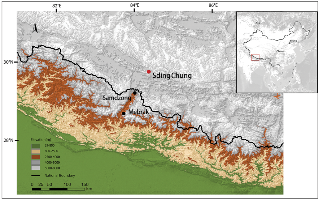
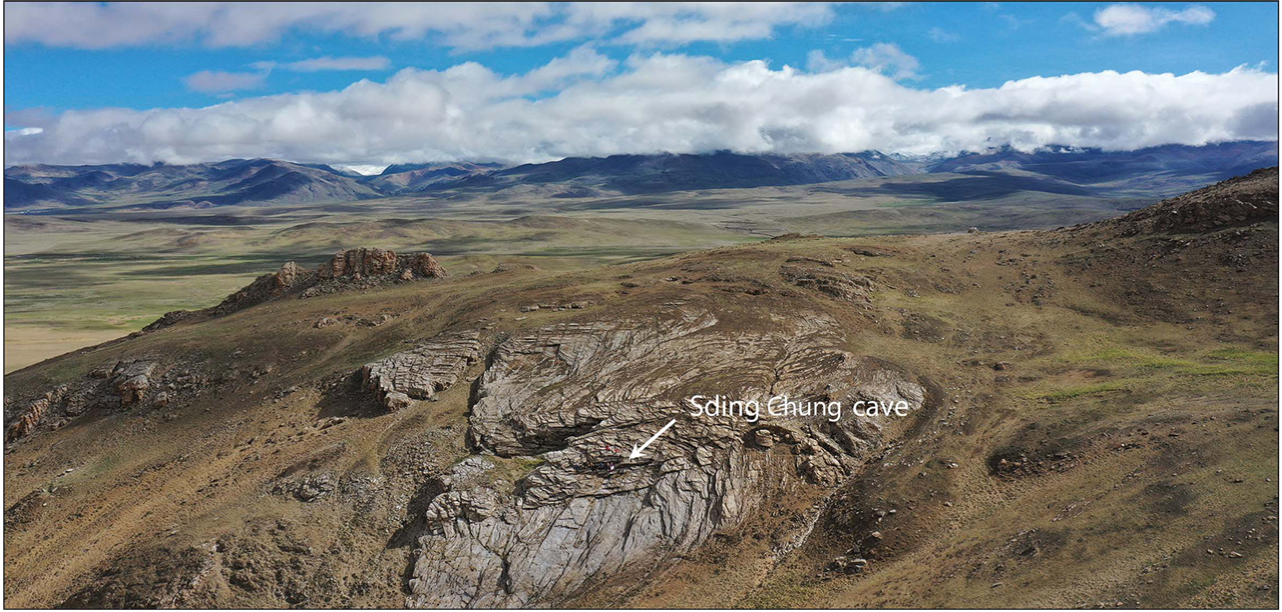
The cave system is located on a mountain slope between the Gangdise and Himalayan Mountain ranges at an altitude of 5000 m. It is thought to have formed when part of the rock body collapsed following water dissolution (essentially as a sinkhole), but is now dry. The cave system is made up of two sets of branching tunnels, connected by a 14 m deep shaft. Both layers contained extensive collections of Human and Animal remains, as well as a few artefacts, which were spread out over the floors of the caves.

The location of the Sding Chung site. Ziyan Li in Lu et al. (2022).

Lu et al. divided the system into twelve units, collecting all artefacts from each of these, as well as taking samples of both the Human and Animal remains, although the majority of these were left in situ. More material was taken from the upper cave than the lower, due to unsafe conditions in the lower cave, and more Human remains were collected than Animal ones, with a preference for collecting skulls. The Human and Animal material was concentrated in a few branch caves, with little material found within the connecting tunnels. 

The landscape of Sding Chung. F Deng in Lu et al. (2022).

The floors of the three larger branches of the upper cave system (SG2, SG3, NG4) had a dense covering of Human and Animal remains, as well as a smaller number of artefacts. With the exception of two individuals found with the pelvis and vertebra attached by soft tissues, the Human remains were disarticulated and intermingled, although it is unclear whether this was done at the time of deposition or by later Human activities (which could have been associated with either ritual practices or looting). The most frequently encountered Human remains were crania, pelvises and limbs, although it is unclear if this was a product of collecting bias (these are generally the largest and most visible parts of a Human skeleton), or reflects a ritual practice in which more of these elements were deposited in the cave. A total of 526 Human bone and bone-fragment samples were identified in the upper caves, representing at least 34 individuals.

Plan and section views of the Sding Chung cave system. Kaiqi Zhang & Ziyan Li in Lu et al. (2022).

The most abundant Animal bones in the caves were those of Caprids (Goats), with those of Bovids, Equids, and Felids also present. Moat of these were found in a single branch cave (SG2). Some of the Animal remains were in the form of articulated limbs, often with skin and other soft tissues still present. At least three overlapping Equid skeletons were present. At least some of the Animal carcasses appear to have been transported to the caves intact. The artefacts found include bronze, ceramic, wooden and Bamboo items, and well as pieces of fabric.

(a) View from the tunnel of the upper cave; (b) the shaft tunnel; (c) scattered skeletons in LG1R; (d) piled Human skulls in LG1R. Hongliang Lu & Ziyan Li in Lu et al. (2022).

The lower caves had a much denser layer of Human and Animal skeletal remains. One of the cave recesses contained a pile of skulls, which appeared to have come from 10-15 individuals, five of which could be observed to have suffered notable injuries, though it is unclear at this time whether these injuries happened before or after death. The lower caves were found to contain 218 observable Human bones and bone fragments, representing at least 26 individuals.

Selected artefacts from Sding Chung: (1) wooden cup; (2) bronze goblet; (3) ceramic shard; (4) textile; (5) fragments of Bamboo weaving; (6) wooden stick. Hailun Xu & Xuan Gao in Lu et al. (2022).

The majority of the Animal bones in the lower caves were skulls, which Hu et al. presume is the result of deliberate selection by the people who placed them there. Once again Caprids were the most common Animals, with Bovids, Equids, and Canids also present. Artefacts were much less common in the lower cave system, and mostly comprise fragments of wood, which Hu et al. speculate may represent fragments of coffins.

The relationship between the remains in the upper and lower caves is unclear. If they can be assumed to represent different sets of individuals, then the minimum total number of individuals present would be 60. However, if some individuals have contributed skeletal remains to both levels, then the minimum total number of individuals present is only 54. It is also quite possible that other remains are present but buried or covered by rock debris or sediment and have not yet been discovered, in which case it is quite possible the caves hold over a hundred sets of Human remains. The Animal remains appear to represent at least 350 individuals.

Hu et al. carried out a limited excavation within the upper part of the Sding Chung cave system, uncovering a 1 m x 1 m area in branch NG1, close to the entrance. This produced a cluster of Bamboo objects, beneath which was a 20 cm ash layer, within which were found numerous burnt Animal bones, two Human bones, one intact bronze goblet, one bamboo cup, several ceramic shards, some wooden sticks, and debris from metal artefacts.

Hu et al. took twelve samples for radiocarbon dating from Human and Animal bones, Bamboo and textiles, from three locations in the upper cave system and one in the lower caves. All of these yielded dates between 300 BC and 300 AD. 

A number of prehistoric burial sites have been found in the Western Himalayas in recent years, although the majority of those being artificial cave or shaft tombs located close to settlements. A notable exception to this has been the cave burials of Mustang District in Nepal. The Sding Chung burials are at a notably higher altitude than most previous burial sites, and appear to represent a previously unknown funerary tradition, possibly involving people living in lowlands but carrying their dead to a higher (and hidden) burial site.

See also...

Follow Sciency Thoughts on Facebook.

Follow Sciency Thoughts on Twitter.