Tuesday, 30 September 2014

Six killed as car falls into sinkhole in Crimean region of Ukaine.

Six people, including five members of one family, have died after a sinkhole opened up in front of a car on a main road near the Crimean city of Simferpol, on the evening of Saturday 27 September 2014. The dead have been named as Ibrail Eskandarov (34), his wife Eskandarova (33) and children Alite (16), and twins Asan and Muslim (3). A family friend, Salimova Asiye (37) who was travelling in the same car was also killed, while her children, Levida (12) and Serim (1) are being treated in the intensive care unit of a local hospital. The sinkhole has been described as eight meters wide and six meters deep, and apparently opened up abruptly in front of the car, giving the driver no time to avoid falling into the hole. Power cables running beneath the road were also severed, hampering rescue attempts due to lack of light.

The remains of a car in the bottom of a sinkhole that opened up on the Nikolayev to Yevpatoria highway near Simferpol on Saturday 27 September 2014. Reuters.

Sinkholes are generally caused by water eroding soft limestone or unconsolidated deposits from beneath, causing a hole that works its way upwards and eventually opening spectacularly at the surface. Where there are unconsolidated deposits at the surface they can infill from the sides, apparently swallowing objects at the surface, including people, without trace.

The area around Simferpol is located on soft limestone, with many extensive cave networks, and has suffered sinkhole related problems in the past, though the cause of this particular incident is still being investigated.

See also...


Seven miners are known to have died and two more are still missing...



Seven workers have been killed and an eighth is being treated in hospital after an explosion at the Skochinsky Coal Mine at Donetsk in eastern Ukraine. The explosion occurred when the miners hit a pocket of...


A house was swallowed by a giant sinkhole at Ridder in eastern Kazakhstan on Tuesday 3 April 2014. The hole, measuring roughly 50 m across and 110 m deep opened abruptly at about 2.30 pm, swallowing...


Follow Sciency Thoughts on Facebook.
 

Eight killed by Earthquake in Peruvian Andes.

The United States Geological Survey recorded a Magnitude 4.9 Earthquake at a depth of 43.2 km in Acamyo Province in the Cusco Region of Peru, at about 9.35 pm local time on Saturday 27 September 2014 (about 2.35 am on Sunday 28 September GMT). The quake was felt across much of the region, and is reported to have caused the collapse of 45 homes and an eighteenth century church in the village of Misca, and led to the deaths of four adults and four children in the village.

Damage in the village of Misca, Peru, following the 27 September 2014 Earthquake. Reuters.

Peru is on the west coast of South America and the western margin of the South American Plate, close to where the Nazca Plate, which underlies part of the east Pacific, is being subducted along the Peru-Chile Trench. The Nazca Plate passes under the South American Plate as it sinks into the Earth, this is not a smooth process and the plates repeatedly stick together then break apart as the pressure builds up, causing Earthquakes. As the Nazca Plate sinks further it is partially melted by the friction and the heat of the Earth's interior. Some of this melted material then rises through the overlying South American Plate, fuelling the volcanoes of Peru and neighbouring countries.

 The subduction of the Nazca Plate beneath the South American Plate, and how it causes Earthquakes and volcanoes. Pacific Earthquake Engineering Research Center.

See also...


http://sciencythoughts.blogspot.co.uk/2014/04/eruption-on-mount-urbinas.html Eruption on Mount Urbinas.                            Mount Urbinas, a small but highly active volcano in the southern Peruvian Andes, generally considered to be Peru's most active volcano, erupted at 7.42 am local time (1.42 pm GMT) on Monday 31 March 2014... 
 
http://sciencythoughts.blogspot.co.uk/2014/03/magnitude-63-earthquake-on-peruvian.html Magnitude 6.3 Earthquake on the Peruvian coast.                                                            The United States Geological Survey recorded a Magnitude 6.3 Earthquake at a depth of 9.8 km, on the coast of Sechura Province in northern Peru, roughly 6...
http://sciencythoughts.blogspot.co.uk/2013/10/magnitude-47-earthquake-in-coronel.html Magnitude 4.7 Earthquake in Coronel Portillo Province, Peru.                                The United States Geological Survey recorded a Magnitude 4.7 Earthquake at a depth of 17.1 km in eastern Coronel Portillo Province, close to the border with Brazil, at...
Follow Sciency Thoughts on Facebook.
 

Monday, 29 September 2014

Calculating the temperature of tropical waters during the Palaeocene-Eocene Thermal Maximum.

The Palaeocene Era was a period of significant global warming, culminating in the Palaeocene-Eocene Thermal Maximum, when around 2000 gigatons of isotopicly light carbon are thought to have been released into the atmosphere over a relatively short time interval (less than 60 000 years), due to melting of deep-sea methane hydrates and permafrost in high latitude and altitude soils. This resulted in a brief period of extreme global warming driven by the sudden input of more-or-less all available greenhouse gasses into the atmosphere, then followed by a period of cooling in the early Eocene as these gasses were lost from the atmosphere.

It should be noted that predictions of the results of human-induced global warming in the near future often predict more severe warming than occurred at the end of the Palaeocene; this is because these scenarios include not just the melting of permafrost and methane hydrates due to warming, but also the pumping of large amounts of carbon dioxide from the burning of fossil fuels (which did not occur during the Palaeocene), and therefore resulting in a much more severe warming, albeit from a cooler starting point.

Though we know that the temperature rose sharply around the globe at the end of Palaeocene, exactly how far it rose in many areas is unclear. One such area is the tropical oceans, which are important for the understanding of global climate patterns. The best way of determining sea temperatures in the past is generally accepted to be oxygen isotope analysis of minerals from the preserved shells of pelagic or planktonic organisms. Such organisms, if they lived close to the surface in open water can give a good measure of the temperature of the water as warmer water contains a higher proportion of isotopicly heavy oxygen. Inshore waters are prone to more extreme temperature fluctuations, as water trapped in enclosed bays can be heated more extremely, but this does not reflect the temperature over wider areas and is therefore not considered useful for understanding global climate patterns.

However this is difficult to study for tropical waters around the Palaeocene-Eocene Thermal Maximum, as the rise in atmospheric carbon dioxide led to oceanic acidification (carbon dioxide dissolves in water to form carbonic acid), leading to a rise in the carbonate compensation depth (the depth beneath which calcium carbonate will dissolve in water – calcium carbonate dissolves more readily at greater pressure, resulting in a pressure boundary rises as the ocean becomes more acidic and falls as the acidity does). Thus many end-Palaeocene deep water sediments, from which microfossil shells are usually extracted to perform oxygen isotope analysis, lack any such shells.

In a paper published in the journal Geology on 25 July 2014, a team of scientists led by Tracy Aze of the School of Earth and Ocean Sciences at CardiffUniversity describe the results of a study of planktonic Foraminifera shells from a location in Tanzania interpreted as having been an outer shelf environment 19˚ from the equator, that was remote from any land but had a depth of only about 300 m (i.e. above the carbonate compensation depth).

Azeet al. analysed specimens of the Foraminifera Acarinina, Morozovella, and Subbotina from across the late Palaeocene and early Eocene. This resulted in a maximum temperature estimate close to the Thermal Maximum of ~36-43˚C, however the sediments around the Thermal Maximum are extremely depleted in Foraminifera, suggesting that temperatures may have been even higher, resulting either in seawater too acidic to preserve calcium carbonate shells or too warm to have been inhabited by Foraminifera.

A Foraminifera of the genus Morozovella. Clay Kelly et al. (2001).

Studies in other areas have suggested that Foraminifera from equatorial and tropical regions migrated towards the poles around the Thermal Maximum, while experiments on modern members of the group suggest that these are unable to tolerate temperatures much above ~33˚C, so that even if Palaeocene Foraminifera were more tolerant of high temperatures, it is difficult to see them surviving in water much above ~43˚C.

See also…

http://sciencythoughts.blogspot.co.uk/2014/04/preserved-wood-from-early-eocene.html Preserved wood from an Early Eocene kimberlite pipe in northwestern Canada’s Slave Province.                                      Kimberlite pipes are produced by rapid volcanic intrusions carrying...
http://sciencythoughts.blogspot.co.uk/2014/04/fossil-thrips-from-early-eocene-of.html Fossil Thrips from the Early Eocene of France.                                                        Thrips (the term is both singular and plural) are tiny (usually less than 1 mm) Insects related to Lice and True Bugs. They have wings, but are poor flyers, and feed by sucking fluids from plant or animal hosts. Thrips do not undergo metamorphosis, the young are essentially smaller, non-reproducing versions of the adults. Due to their small size and ubiquitous nature, it is...
 Follow Sciency Thoughts on Facebook.


Follow Sciency Thoughts on Facebook.

Ten confirmed dead and at least 26 missing following eruption on Mount Ontake, Japan.

Ten people have been confirmed dead and 63 have been injured following an unpredicted eruption of Mount Ontake on central Honshū on Saturday 27 September 2014. At least 26 people remain unaccounted for on the volcano, which is a popular tourist attraction and was packed with tourists, many of whom were families with children, at the time of the eruption. Searches for survivors have had to be called off today (Monday 29 September) due to fears of toxic gas being emitted by the volcano. While many of the injured are reportedly suffering from broken limbs or similar injuries sustained during the rapid evacuation of the mountain, the major cause of fatalities is likely to be asphyxiation due to fine ash falling on unwary hikers.

Tourist lodges covered with ash on Mount Ontake. Reuters.

Ontake is the second highest volcano in Japan at 3067 m, and for most of its history has been considered inactive. However it erupted in 1979-80 producing around 200 000 tons of ash, and since then as undergone minor eruptions in 1991, 2007 and 2008, though there has been no precedent for the September 2014 eruption.

Japan has a complex tectonic environment with four plates underlying parts of the Islands; in addition to the Pacific in the east and the Okhosk in the North, there are the Philippine Plate to the south and the Eurasian Plate to the West. Kyūshū Island lies at the northeast end of the Ryukyu Island Arc, which sits on top of the boundary between the Eurasian and Philippine Plates. The Philippine Plate is being subducted beneath the Eurasian Plate, in the Ryukyo Trench, to the Southeast of the Islands. This is not a smooth process, with the two plates continuously sticking together then breaking apart as the pressure builds up, leading to frequent Earthquakes in the region.


 The movement of the Pacific and Philippine Plates beneath eastern Honshu. Laurent Jolivet/Institut des Sciences de la Terre d'Orléans/Sciences de la Terre et de l'Environnement.

See also...

 
The Japan Meteorological Agency recorded a Magnitude 6.1... 


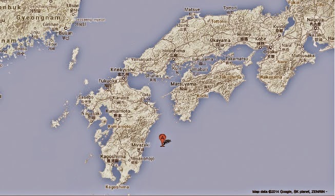
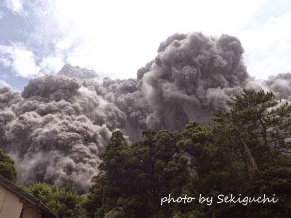
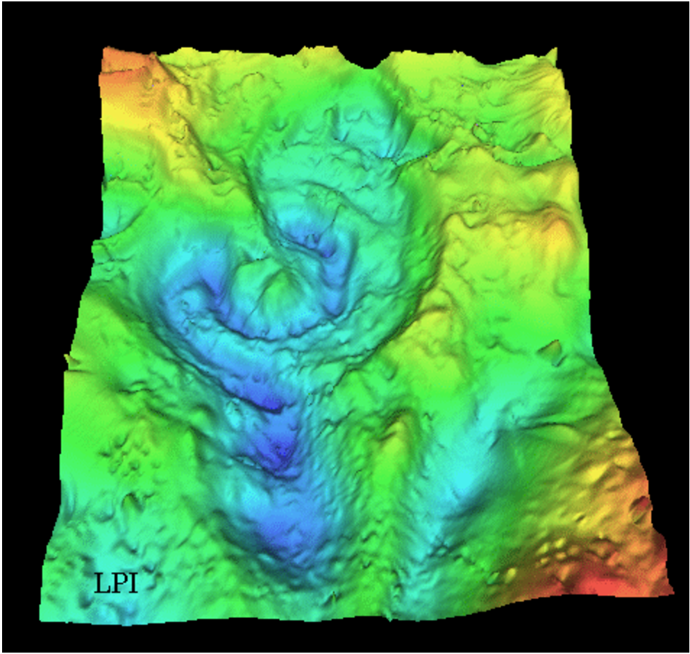
http://sciencythoughts.blogspot.co.uk/2014/08/eruptionand-pyroclastic-flow-on-mount.html Eruption and pyroclastic flow on Mount Furudake.                                                         The Japan Meteorological Agency recorded an eruption on Mount Furudake on Kuchinoerabujima, an island about 130 km south of Kagoshima, at about 12.25 pm local time on Sunday 3 August 2014. The eruption consisted of a single powerful explosion followed by the...
 
http://sciencythoughts.blogspot.co.uk/2014/06/magnitude-55-earthquake-in-iwate.html Magnitude 5.5 Earthquake in Iwate Prefecture, Japan.  The Japan Meteorological Agency recorded a Magnitude 5.5 Earthquake at a depth of 90 km in eastern Iwate Prefecture on northern Honshū Island, Japan, slightly after 2.35...
Follow Sciency Thoughts on Facebook.


Saturday, 27 September 2014

The genetic diversity of the Northern Pike and itrs relationship with the Amur Pike.

The Northern Pike, Esox lucius, is a large, carnivorous Fish found in freshwater ecosystems across the Northern Hemisphere. Populations of Northern Pike are found across Europe, northern Asia and northern North America, and are thought to have expanded across this range from one or two refugia at the end of the last Ice Age, possibly crossing the Bering Land Bridgebetween Siberia and Alaska. It is thought to be closely related to the Amur Pike, Esox reichertii, which is found only in the Amur River Basin in East Asia, which is separated from the other river basins of Siberia (where the Northern Pike is found) by the Yablonovy and Stanovoy mountain ranges. Three other species of Pike are known from more southerly North American waterways, The American Pickerel, Esox americanus, the Muskellunge, Esox masquinongy and the Chain Pickerel Esox niger, and two new species have recently been described from Italy, the Southern Pikes, Esox cisalpinus and Esox flaviae, though as these two species were described separately they may turn out to be the same species.

The Northern Pike, Esox lucius. Animal Base.

In a paper published in the journal Frontiers in Zoology on 16 September 2014, Anna Skog of the Centre for Ecological and EvolutionarySynthesis at the Department of Biosciences at the University of Oslo and the CancerRegistry of Norway, Asbjørn Vøllestad and Nils Stenseth, also of the Centre for Ecological and Evolutionary Synthesis, Alexander Kasumyan of the Department ofIchthyology at the Faculty of Biology at Moscow State University and Kjetill Jakobsen, also of the Centre for Ecological and Evolutionary Synthesis describe the results of  genetic study of 24 populations of Northern Pike and three populations of Amur Pike, intended to determine the relationships between the two species.

Skog et al. determined that the Amur Pike is genuinely a separate species to the Northern Pike the two species having apparently separated about 4.55 million years ago. The Northern Pike shows less genetic diversity across its entire range than the related Muskellunge, though this has a much more limited range The Amur Pike has a similarly limited genetic diversity.

The Amur Pike, Esox reichertii. Pikefinder.

The Northern Pike’s populations can be divided into three distinct genetic lineages, which split about 200 000 to 300 000 years ago (i.e. during the Late Pleistocene). All northern populations of Pike belong to a single one of these populations, with the remaining two populations found at more southerly latitudes within Europe only, one in Western Europe, the other in the Danube Basin.

This strongly suggests that all northern populations of the Northern Pike are descended from an ancestral population in a single refugia, that spread around the Arctic Circle at or after the end of the Pleistocene. Within this population, the highest genetic diversity is found in the Ural River population, suggesting that all modern Northern Pike of the circumpolar population may be descended from a Pleistocene population in this area, though Skog et al. do not rule out a refugia in West Siberia or even Beringia (the land between Alaska and Siberia that was exposed by low sea levels during the Ice Ages, but which is covered by sea now).

See also…

http://sciencythoughts.blogspot.co.uk/2014/06/african-tigerfish-observed-snatching.html African Tigerfish observed snatching Barn Swallows from the air.                                      A variety of Fish are known to occasionally take Birds as prey. Sharks...


Follow Sciency Thoughts on Facebook.

Thursday, 25 September 2014

How changes in Plant ecology shed light on the End Cretaceous Extinction Event.


One of the two main theories that seeks to explain the extinction event at the end of the Cretaceous postulates that a large bolide (extra-terrestrial object such as a comet or asteroid) smashed into the Yucatan Peninsula in Mexico close to the modern town of Chicxulub, resulting in a devastating explosion and long term climate change. Such an event would have led to a ‘nuclear winter’ as large amounts of material thrown up into the atmosphere significantly reduced the amount of sunlight reaching the planets surface, leading to a breakdown in food chains and causing the mass extinction event.

Such an event would have a profound impact on plant survival strategies, as darker skies would lead to a much shorter growing season, favouring deciduous plants over evergreens. It is difficult to tell directly from the fossil record whether a plant was deciduous or evergreen in nature, though deciduous plants on the whole have lower leaf mass per area (high leaf mass requires higher carbon investment) and higher vein densities (which aids carbon assimilation), so comparison of these two measures across an ecosystem should give some indication as to whether it was dominated by deciduous or evergreen forms.

In a paper published in the journal PLoS Biology on 16 September 2014, a team of scientists led by Benjamin Blonder of the Department of Ecologyand Evolutionary Biology at the University of Arizona and the Rocky MountainBiological Laboratory in Gothic, Colorado, describe the results of an analysis of fossil leaves from the Hell Creek and Fort Union formations in southwestern North Dakota, which cover a 2.2 million year section across the Cretaceous/Palaeocene boundary (the last 1.4 million years of the Cretaceous and first 800 000 years of the Palaeocene).

Blonder et al. found that the leaf mass per area of leaves in the study dropped by an average of 6 grams of dry leaf mass per meter squared across the Cretaceous/Palaeocene boundary, while vein density rose by 1.1 mm of vein per mm2 of leaf area across the boundary. These are small values across the total range of variability found in modern plants, but consistent with a change in ecosystem from (for example) tropical rainforest to tropical deciduous forest.

Visual representations of trait changes across the Cretaceous/Palaeocene Boundary. Top row, increase in vein density as seen in (A), ‘‘Dryophyllum’’subfalcatum,230.7 m stratigraphic depth, vein density = 2.5 mm-1 and (B) unknownnonmonocot (morphospecies FU87), 1.275 m depth, VD = 5.3 mm-1.Bottom row, decreases in leaf mass per area as seen through decreasing petiole width forsimilar leaf area in (C) ‘‘Ficus’’planicostata, 23.6 m depth, leaf mass per area = 136 g m-2and (D) ‘‘Populus’’nebrascensis, 7.2 m depth, leaf mass per area = 48 g m-2. Scale bars,(A and B) 500 mm and (C and D), 5 mm. Blonder et al. (2014).

These variables have been shown to change across the Cretaceous/Palaeocene boundary before, but over longer periods and over wider areas. By producing a study of a much shorter time-span over a limited area, Blonder et al. hope to provide evidence for a much faster change in ecosystem than was previously possible. They note that a drop in leaf mass per area and rise in vein density could also be caused by a drop in atmospheric carbon dioxide, which is a probable symptom of the other main theoretical cause of the End Cretaceous Extinction Event, the extensive volcanism associated with the formation of the Deccan Traps flood basalts in India. However such volcanism would be more likely to cause a long-term drop in atmospheric carbon dioxide, leading to a gradual change in leaf mass per area and vein density, where as the study supports an abrupt change in variables, harder to explain though a change in atmospheric chemistry, unless this was more sudden than could be explained by our current understanding of flood volcanism.
 
See also…


The Earth has been dominated by multi-cellular life forms (animals...


http://sciencythoughts.blogspot.co.uk/2014/03/the-nature-of-chicxulub-impactor.html The nature of the Chicxulub impactor.                                                                                  65 million years ago, at the end of the Cretaceous, the Earth underwent the last of the five great mass extinctions recorded in the fossil record. While this is by no means the largest of these events, it is the most familiar to the general public, as it was responsible for the extinction of, amongst other things, the non-Avian Dinosaurs and the large marine Reptiles of...
  
http://sciencythoughts.blogspot.co.uk/2013/09/opportunistic-bivalves-during-early.html Opportunistic Bivalves during the Early Jurassic Toarcian Oceanic Anoxic Event.        The Toarcian Oceanic Anoxic Event is an extinction event that took place in the Early Jurassic, about 183 million years ago. It took place in four phases, thought to have been related to Milankovitch Cycles. During each phase the temperature of the global ocean is thought to have risen abruptly by as much as 13℃, leading to a...
 
Follow Sciency Thoughts on Facebook.

Wednesday, 24 September 2014

A parasitic Cymothoid Isopod from the Virgin Islands.


Cymothoids are Isopod Crustaceans, related to terrestrial Woodlice and Pill Bugs, but found in marine environments, where they are parasitic on Fish, typically living in the throat or gills, or on the external surface of the skin. Species which infest the gills of their host are often asymmetrical, with a slightly twisted shape that reflects the shape of the gill arches. These Crustaceans are typically quite harmful to their hosts, causing damage to the gills and branchial filaments, often leading to loss of part of the gills, with a subsequent effect on the development of the Fish.

In a paper published in the journal Zookeys on 10 September 2014, Kerry Hadfield of the Water Research Group (Ecology) at the Unit for Environmental Sciences and Management at North West University, Paul Sikkel of the Department of Biological Sciences at Arkansas State University and Nico Smit, also of the Water Research Group (Ecology), describe a new species of Cymothoid Crustacean from the Virgin Islands.

The new species is placed in the genus Mothocya and given the specific name bertlucy, in honour of Ernest H. (‘Bert’) Williams Jr. and Lucy Bunkley-Williams of the University of PuertoRico, on the occasion of their retirement, and in recognition of their contribution to the study of parasitology in the marine ecosystems of the Caribbean. Mothocyabertlucy was found infesting the gills of the Redlip Blenny, Ophioblennius macclurei around St. John Island and St Thomas Island in the US Virgin Islands and Guana Island in the British Virgin Islands.

Mothocya bertlucy(top) female and (bottom) male, both in lateral view. Hadfield et al. (2014).

Mature females of Mothocya bertlucy reach 7.0-9.0 mm in length and are slightly twisted. Males reach about 6.0 mm in length and are untwisted. The species is small compared to other members of the genus, and has small eyes for its size. It is the first species of Mothocyato have been found infecting a Blenny.

Mothocya bertlucy(left) female and (right) male, both in dorsal view. Hadfield et al. (2014).
 
See also…


Isopods are one of the most numerous and diverse groups of Crustaceans in modern environments, but while preserved specimens are known from as far back as the Carboniferous, they have a limited presence in the fossil record, largely because their exoskeletons...


http://sciencythoughts.blogspot.co.uk/2012/10/a-new-isopod-crustacean-from-limestone.html A new Isopod Crustacean from a limestone cave in Brazil.                                                                                                                   Isopods are small, flat, benthic Crustaceans known from marine, freshwater and terrestrial environments, where they are known as Woodlice or Pill Bugs, due to the tendency of many species to roll up into tight balls...

http://sciencythoughts.blogspot.co.uk/2012/08/two-new-species-of-freshwater-isopod.html Two new species of freshwater Isopod Crustaceans from Lake Pedder in Tasmania.                                                         In 1972 two small shallow lakes in southwest Tasmania, Lake Pedder and Lake Edgar, were inundated to create a reservoir to feed a hydroelectric power scheme, also called Lake Pedder, in the Serpentine River Valley. This was a source of great concern to biologists as the...

Follow Sciency Thoughts on Facebook.