
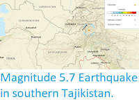
The United States Geological Survey recorded a Magnitude 4.9 Earthquake at a depth of 10.0 km, roughly 41 km to the northeast of the town of Magdanly in the Lebap Region of eastern Turkmenistan, slightly before 5.30 am local time (slightly before 0.30 am GMT) on Sunday 6 December 2020. There are no reports of any damage ot casualties associated with this event, but it is likely to have been felt locally.

Turkmenistan lies to the north of the boundary between the Indian and Eurasian tectonic plates, which runs through northern Afghanistan. The Indian Plate is moving northward relative to the Eurasian Plate, causing folding and uplift along this boundary, which has led to the formation of the Hindu Kush Mountains of Afghanistan, The Himalayas and the other mountain ranges of Central Asia, and which makes the nations in this boundary zone prone to Earthquakes.
See also...


Follow Sciency Thoughts on Facebook.
Follow Sciency Thoughts on Twitter.