Showing posts with label Bohol Island. Show all posts

Sunday, 8 April 2018

Dardanus balhibuon: A new species of Hermit Crab from Pamilacan Island, the Philippines.

Hermit Crabs, Paguroidea, are highly specialised Decapod Crustaceans that have largely soft exoskeletons and recycle the shells of other animals, usually Gastropod Molluscs, as protection for their bodies. This enables them to live high in the littoral zone (beach environments) where calcium for making shells is hard to get but Crab-eating predators are common, thereby exploiting an environment effectively closed to other Crabs. Hermit Crabs are found on beaches throughout the world's tropical and temperate regions, though they are far more abundant in the tropics, and some members of the group have colonised other environments.
 
In a paper published in the Raffles Bulletin of Zoology on 17 January 2018, Maria Celia Malay of the Division of Biological Sciences at the University of the Philippines Visayas, Dwi Listyo Rahayu of the Marine Bio-Industry Implementation Unit of the Research Centre for Oceanography of the Indonesian Institute of Sciences, and Tin-Yam Chan of the Institute of Marine Biology and Center of Excellence for the Oceans at the National Taiwan Ocean University, describe a new species of Hermit Crab from Pamilacan Island in Bohol Province, the Philippines, as part of a wider study of Hermit Crabs in the Philippines.

The new species is placed in the genus Dardanus and given the specific name balhibuon, meaning 'hairy'. The species is described from a single female specimen collected from a subtidal reef slope on Pamilacan Island in 2004 and held in the collection of the National Museum of the Philippines in Manila. This specimen was originally labelled as belonging to the species Dardanus lagopodes, but is now recognised as belonging to a separate species due to its larger size and general hairiness. This specimen is 14.3 mm in length, and is an orange-brown colour after being preserved in alcohol for over a decade, though it was probably originally purplish red (i.e. similar in colour to Dardanus lagopodes). 
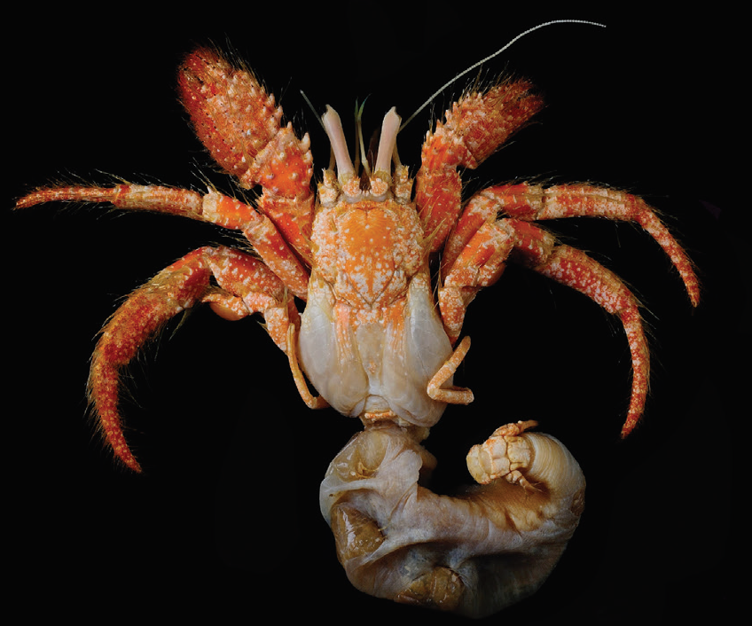
Dardanus balhibuon, female specimen preserved in alcohol since 2004. Malay et al. (2018).

See also...

http://sciencythoughts.blogspot.co.uk/2017/12/pleistacantha-kannu-new-species-of.htmlhttp://sciencythoughts.blogspot.co.uk/2017/11/coconut-crabs-observed-predating.html
http://sciencythoughts.blogspot.co.uk/2017/11/salangathelphusa-peractio-new-species.htmlhttp://sciencythoughts.blogspot.co.uk/2017/09/court-issues-28-220-in-fines-and.html
http://sciencythoughts.blogspot.co.uk/2017/06/tomopaguropsis-rahayuae-deepwater.htmlhttp://sciencythoughts.blogspot.co.uk/2017/04/kani-maranjandu-new-species-of-tree.html
Follow Sciency Thoughts on Facebook.

Monday, 30 March 2015

Magnitude 4.8 Earthquake to the south of Bohol Island in the Philippines.

The United States Geological Survey recorded a Magnitude 4.8 Earthquake at a depth of 35 km off the south coast of Bohol Island in the Philippines, slightly before 9.50 am local time (slightly before 1.50 am GMT) on Monday 30 March 2015. There are no reports of any damage or injuries associated with this event, though it was felt across much of Bohol and Cebu islands.

The approximate location of the 30 March 2015 Luzon Earthquake. Google Maps.

The geology of the Philippines is complex, with the majority of the islands located on the east of the Sunda Plate. To the east of this lies the Philippine Sea plate, which is being subducted beneath the Sunda Plate (a breakaway part of the Eurasian Plate); further east, in the Mariana Islands, the Pacific Plate is being subducted beneath the Philippine Sea Plate. This is not a smooth process, and the rocks of the tectonic plates frequently stick together before eventually being broken apart by the rising pressure, leading to Earthquakes in the process.

Subduction beneath the Philippines. Yves Descatoire/Singapore Earth Observatory.

See also...

The United States Geological Survey recorded a Magnitude 5.3 Earthquake at a depth of 10 km about 37 km off the east coast of Luzon Island in the...


The United States Geological Survey recorded a Magnitude 5.3 Earthquake at a depth of 38 km, roughly 6 km offshore of the city of Hinundayan in...


The Philippine Institute of Volcanology and Seismology has recorded an increase in seismic activity over the past 24 hours (Saturday 28-Sunday 29 June 2014) beneath Mount Mayon, a 2463 m stratovolcano (cone shaped volcano) on southern Luzon Island. White smoke has also been seen...


Follow Sciency Thoughts on Facebook.

Friday, 25 April 2014

Magnitude 4.6 Earthquake off Bohol Island, the Philippines.

The United States Geological Survey recorded a Magnitude 4.6 Earthquake at a depth of 10.0 km off the coast of Bohol Island in the Philippines, roughly 3 km northwest of the town of Inabanga, slightly before 3.00 pm local time (slightly before 7.00 am GMT) on Friday 25 April 2014. This is a moderate sized Earthquake was felt on both Bohol and Cebu islands, though there are no reports of any damage or injuries.

The approximate location of the 25 April 2014 Bohol Earthquake. Google Maps.

The geology of the central Philippines is Complex. The west of Mindanao Island is located on the Banda (or Sunda) Microplate, and the east on the Philippine Plate, which is being subducted beneath the Sunda (or Banda) Microplate along the central part of the island. Immediately to the east of the Island the Pacific Plate is being subducted along the Philippine Trench. The subducting Philippine Plate passes under the islands if Bohol and Cebu as it sinks into the Earth. This is not a smooth process, an the plates constantly stick together then break apart again as the pressure builds up, resulting in Earthquakes.

See also...


Follow Sciency Thoughts on Facebook.

Wednesday, 16 October 2013

Magnitude 7.1 Earthquake on Bohol Island, the Philippines.

The United States Geological Survey recorded a Magnitude 7.1 Earthquake at a depth of 20 km on Bohol Island in the Philippines slightly after 8.10 am on Tuesday 15 October 2013. Earthquakes of this size in populated areas are extremely dangerous, and this one is known to have caused at leas 93 casualties (69 on Bohol and the remainder on neighbouring Cebu and Siquijor Islands) and well as causing the total or partial collapse of a large number of buildings, including homes, churches and commercial properties. Since the initial event there have been dozens of aftershocks, many exceeding Magnitude 5.0, contributing to the problems caused by the initial quake.

Damage to buildings in Cebu City on Cebu Island. AFP.

The geology of the central Philippines is Complex. The west of Mindanao Island is located on the Banda (or Sunda) Microplate, and the east on the Philippine Plate, which is being subducted beneath the Sunda (or Banda) Microplate along the central part of the island. Immediately to the east of the Island the Pacific Plate is being subducted along the Philippine Trench. The subducting Philippine Plate passes under the islands if Bohol and Cebu as it sinks into the Earth. This is not a smooth process, an the plates constantly stick together then break apart again as the pressure builds up, resulting in Earthquakes.

The approximate location of the 15 October 2013 Bohol Island Earthquake. Google Maps.


Follow Sciency Thoughts on Facebook.