Showing posts with label Sangihe Plate. Show all posts

Thursday, 21 August 2025

Two deaths following Magnitude 5.8 Earthquake beneath Central Sulawesi, Indonesia.

The United States Geological Survey recorded a Magnitude 5.8 Earthquake at a depth of 12 km, approximately 12 km to the northwest of the town of Poso in Central Sulawesi Province, Indonesia, slightly before 6.40 am local time on Sunday 17 August 2025 (slightly before 10.40 pm on Sunday 16 August, GMT). Twenty nine people are known to have been injured during this event, two of whom subsequently died, one later on the day of the event, and one on Tuesday 19 August. The initial quake was followed by a series of aftershocks.

The approximate location of the 17 August 2025  Central Sulawesi Province Earthquake. USGS.

The tectonic situation beneath Sulawesi is complex, as it is caught in the collisional zone between the Eurasian, Pacific and Australian Plates. The north of the island is located on a breakaway section of the Eurasian Plate, called the Sangihe Plate. To the east lies the remnant Molucca Sea Plate, which is being subducted beneath both the Sangihe Plate and the more easterly Halmahera Plate, leading to Earthquakes and volcanism on Sulawesi and the islands of the Sangihe Arc in the west and the islands of the Halmahera Arc in the east.

The subduction zones beneath Sulawesi and the surrounding islands. Hall & Spakman (2015).

See also...

Thursday, 2 May 2024

Islands evacuated after major eruption on Mount Ruang, Indonesia.

The Indonesian Meteorology, Climatology and Geophysics Agency has reported a major series of eruptions on Mount Ruang, an island volcano at the southern tip of the Sangihe Islands, which has prompted the evacuation of both Ruang Island and the nearby Tagulandang Island, more than 12 800 people in total. The volcano erupted three times on Tuesday 30 April 2024, producing ash columns which rose to more than 5 km above sealevel, and drifted west as far as Borneo. Seven airports in Indonesia have been forced to close temporarily due to the dangers of ash from the volcano.

An eruption on Mount Ruang, Indonesia, on 30 April 2024, seen from Tagulandang Island. Endha Reifel Pontoh/Reuters.

The Sangihe Island Arc is a chain of volcanic islands running between the northern tip of Sulawesi and the southern tip of Mindanao. The chain marks the boundary between the Molucca Plate to the east and the Sangihe Plate to the west, with the Molucca Plate being subducted beneath the Sangihe Plate. As the Molucca Plate sinks into the Earth it is heated by the friction and the heat of the planet's interior, causing it to partially melt. Some of the melted material then rises through the overlying Sangihe Plate as magma, fuelling the volcanoes of the Sangihe Arc.

The subduction zones beneath Sulawesi and the surrounding islands. Hall & Spakman (2015).

See also...

Thursday, 14 January 2021

Magnitude 6.2 Earthquake beneath West Sulawesi, Indonesia.

The United States Geological Survey recorded a Magnitude 6.2 Earthquake at a depth of 18.4 km, approximately 36 km to the south of the city of Mamuju in West Sulawesi Province, Indonesia, slightly before 2.30 am local time on Friday 15 January 2021 (slightly before 6.30 pm on Thursday 14 January, GMT). There are no reports of any damage or injuries relating to this event at this time, but people have reported feeling it locally.

 
The approximate location of the 15 January 2021 West Sulawesi Province Earthquake. USGS.

The tectonic situation beneath Sulawesi is complex, as it is caught in the collisional zone between the Eurasian, Pacific and Australian Plates. The north of the island is located on a breakaway section of the Eurasian Plate, called the Sangihe Plate. To the east lies the remnant Molucca Sea Plate, which is being subducted beneath both the Sangihe Plate and the more easterly Halmahera Plate, leading to Earthquakes and volcanism on Sulawesi and the islands of the Sangihe Arc in the west and the islands of the Halmahera Arc in the east.

 
The subduction zones beneath Sulawesi and the surrounding islands. Hall & Spakman (2015).

See also...


Follow Sciency Thoughts on Facebook.

Follow Sciency Thoughts on Twitter.
 

Saturday, 9 February 2019

Eruption on Mount Karangetang triggers pyroclasitc flow.

Authorities on the Indonesian island of Siau, in the Sangihe Archipelago to the north of Sulawesi, have extended an exclusion zone around Mount Karangetang, a 1784 m high stratovolcano (cone-shaped volcano) on the northern end of the island, following a pyroclastic flow (flow of heavy superheated gas containing large amounts of hot ash, rocks and debris) on Tuesday 5 February 2019, which blocked a road on the island. Mount Karangetang is one of Indonesia's most active volcanoes, typically erupting several times per year, with the current phase of eruptions having begun in November 2018, after several months of inactivity.

Pyroclastic flow blocking a road on Siau Island, Indonesia on 5 February 2019. 3 alacarta.

Siau Island is quite densely populated with around 22 000 permanent residents, and Mount Karangetang frequently causes problems for the islanders, having most recently caused fatalities in August 2010. The Sangihe Island Arc is a chain of volcanic islands running between the northern tip of Sulawesi and the southern tip of Mindanao. The chain marks the boundary between the Molucca Plate to the east and the Sangihe Plate to the west, with the Molucca Plate being subducted beneath the Sangihe Plate. As the Molucca Plate sinks into the Earth it is heated by the friction and the heat of the planet's interior, causing it to partially melt. Some of the melted material then rises through the overlying Sangihe Plate as magma, fuelling the volcanoes of the Sangihe Arc.

 The subduction zones beneath Sulawesi and the surrounding islands. Hall & Spakman (2015).

See also...

https://sciencythoughts.blogspot.com/2018/12/eruption-on-mount-soputan-sulawesi.htmlhttps://sciencythoughts.blogspot.com/2018/09/thousands-feared-dead-after-earthquake.html
https://sciencythoughts.blogspot.com/2014/09/eruptions-on-mount-lokon-sulawesi.htmlhttps://sciencythoughts.blogspot.com/2013/10/eruptions-on-mount-dukono-on-halmahera.html
https://sciencythoughts.blogspot.com/2013/09/magnitude-57-earthquake-of-north-coast.htmlhttps://sciencythoughts.blogspot.com/2013/09/explosive-eruption-on-mount-lokon.html
Follow Sciency Thoughts on Facebook.

Sunday, 16 December 2018

Eruption on Mount Soputan, Sulawesi.

The Volcanological Survey of Indonesia has reported a major new eruption on Mount Soputan, a highly active stratovolcano (cone-shaped volcano made up of layers of ash and lave) on northern Sulawesi. The agency began to detect seismic events (tremors) beneath the volcano at about 5.00 pm local time on Saturday 15 December 2018, which increased slowly overnight, with minor eruptive activity beginning at about 1.00 am, with lava fountains beginning at about 3.10 am. At about 5.40 am the volcano began to erupt far more energetically, producing an ash column that rose to about 8.8 km above sealevel.

An ash column over Mount Soputan, Sulaweisi, on the morning of Sunday 16 December 2018. Badan Nasional Penanggulangan Bencana.

Soputan is a small volcano in the Tondano Caldera located near the eastern tip of the northern arm of Sulawesi. The volcanoes of the northern arm of Sulawesi are located at the southern end of the Sangihe Volcanic arc, where an extension Molucca Sea Plate is being subducted beneath an extension of the Eurasian Plate, sometimes called the Sangihe Plate. As this happens part of the subducting plate is melted by the heat of the Earth's interior, and rises up through the overlying plate as liquid magma, forming volcanoes at the surface. About 320 km to the east, the Molucca Plate is also being subducted beneath an extension of the Philippine Plate, sometimes called the Halmahera Plate, producing a second chain of volcanoes in the Halmahera Islands. At some point in the future the Molucca Plate will vanish and the two volcanic arcs will meet.

The subduction zones beneath Sulawesi and the surrounding islands. Hall & Spakman (2015).

See also...

https://sciencythoughts.blogspot.com/2018/09/thousands-feared-dead-after-earthquake.htmlhttps://sciencythoughts.blogspot.com/2015/01/eruption-on-mount-soputan.html
https://sciencythoughts.blogspot.com/2014/09/eruptions-on-mount-lokon-sulawesi.htmlhttps://sciencythoughts.blogspot.com/2014/01/at-least-16-dead-after-landslides-at.html
https://sciencythoughts.blogspot.com/2013/09/magnitude-57-earthquake-of-north-coast.htmlhttps://sciencythoughts.blogspot.com/2013/09/explosive-eruption-on-mount-lokon.html
Follow Sciency Thoughts on Facebook.

Sunday, 30 September 2018

Thousands feared dead after Earthquake and tsunami hit Sulawesi.

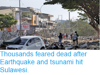
832 people have now been confirmed dead and it is feared that the eventual total will reach into the thousands following an Earthquake on northern Sulawesi on Friday 28 September 2018, which triggered a tsunami. The event was recorded by the United States Geological Survey as a Magnitude 7.5 Earthquake at a depth of 10 km, roughly 78 km to north of the city of Palu, which occurred slightly after 6.00 pm local time (slightly after 10.00 am GMT), and was felt across the island of Sulawesi and on eastern parts of Borneo. The majority of the confirmed fatalities so far (821) have been in the city of Palu, but it is likely far more people have died in the Donggala Regency to the north of the city, where the Earthquake occurred and which was inundated by the tsunami after the event.

Debris in the streets of Palu, Sulawesi, following an Earthquake and tsunami on 28 September 2018. Haritsah Almudatsir/Jawa Pos.

The tectonic situation beneath Sulawesi is complex, as it is caught in the collisional zone between the Eurasian, Pacific and Australian Plates. The north of the island is located on a breakaway section of the Eurasian Plate, called the Sangihe Plate. To the east lies the remnant Molucca Sea Plate, which is being subducted beneath both the Sangihe Plate and the more easterly Halmahera Plate, leading to Earthquakes and volcanism on Sulawesi and the islands of the Sangihe Arc in the west and the islands of the Halmahera Arc in the east.

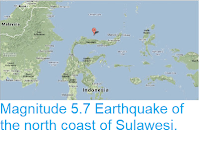
The approximate location of the 28 September 2018 Sulawesi Earthquake. USGS.

Earthquakes along subductive margins are particularly prone to causing tsunamis, since these often occur when the overlying plate has stuck to the underlying plate, being pulled out of shape by its movement.. Eventually the pressure builds up to far and the overlying plate snaps back, causing an Earthquake and a tsunami. 


Simplified graphic showing tsunami generation along a convergent margin.NASA/JPL/CalTech.

Witness accounts of Earthquakes can help geologists to understand these events, and the structures that cause them. The international non-profit organisation Earthquake Report is interested in hearing from people who may have felt this event; if you felt this quake then you can report it to Earthquake Report here.
 
See also...
 
https://sciencythoughts.blogspot.com/2015/01/eruption-on-mount-soputan.htmlhttps://sciencythoughts.blogspot.com/2014/09/eruptions-on-mount-lokon-sulawesi.html
https://sciencythoughts.blogspot.com/2014/01/at-least-16-dead-after-landslides-at.htmlhttps://sciencythoughts.blogspot.com/2013/09/magnitude-57-earthquake-of-north-coast.html
https://sciencythoughts.blogspot.com/2013/09/explosive-eruption-on-mount-lokon.htmlhttps://sciencythoughts.blogspot.com/2013/07/four-people-killed-by-landslide-in.html
Follow Sciency Thoughts on Facebook.