The Grand Canyon is an internationally renowned tourist attraction, drawing visitors from all over the world. It is also viewed as a sacred place by many Native Americans, many of whom make their home there. The Colorado River has been carving out the canyon for over 3 million years, and provides a major source of water for about 40 million people in the United States and Mexico. However, in the area immediately around the Grand Canyon, the water needs of both residents and visitors is almost entirely met from groundwater. This water supply is threatened by a warming climate, as this is associated with a drying environment locally, lowering the rate at which groundwater reserves are recharged. The Grand Canyon region is also home to some of the richest deposits of uranium in the US. Concerns about the impact of this industry on the local water supply led to a 20-year moratorium on new mining activity being put into place in 2012, since which time the United States Geological Survey has been carrying out extensive monitoring of the relationship between mining and water supplies in the region, with the objective of enabling future policy-makers to make informed decisions about uranium mining around the Grand Canyon.
While it is obvious that uranium entering the water supply would be a bad thing, other metals present in uranium ore deposits are probably a greater threat to Human health. Arsenic in particular, while present to an extent in all soils, rocks, and groundwater supplies, is particularly of concern in the Grand Canyon region, and is known to be present in the minerals of the breccia pipe deposits targeted by uranium miners in the area. Elevated levels of arsenic in drinking water are associated with a range of health problems, including skin lesions and cancer of the lung, bladder, kidney, and liver, and both the United States Environmental Protection Agency and World Health Organization set the maximum safe level of arsenic in water supplies at 10 μm/L, whereas the equivalent level for uranium is 30 μm/L.
In a paper published in the journal PLoS Water on 14 June 2023, Fred Tillman of the Arizona Water Science Center of the United States Geological Survey, Kimberly Beisner of the New Mexico Water Science Center of the United States Geological Survey, and Casey Jones of the South Atlantic Water Science Center of the United States Geological Survey, present an analysis of the arsenic content of groundwater in the Grand Canyon area, and its relationship to potential sources, including the mining of uranium.

The Grand Canyon region is sparsely populated, and therefore has a limited number of water extraction wells, something which makes it difficult to assess the extent of the aquifers these wells target. In the absence of such data, topographic features are assumed to deliminate the extent of these aquifers. Tillman et al. looked at an area containing watersheds flowing into the Colorado River between Lees Ferry to the east and the Grand Wash Cliffs to the west. There are known to be two groundwater systems in this area. The shallower of these is a perched aquifer 300 m below the plateau surface, which runs through the in the Permian-age Kaibab Formation, Toroweap Formation, and Coconino Sandstone, which is thought only to be present in the area immediately around the Grand Canyon. The deeper system is about 1 km beneath the plateau surface, and runs through the Mississippian-age Redwall Limestone, the Devonian-age Temple Butte Formation, and the underlying Cambrian-age Muav Limestone of the Tonto Group, which is thought to be present over a much wider area, except where the water-bearing units have been eroded away by canyon formation.
Uranium in the Grand Canyon has been mined from breccia pipes (cave systems, often of volcanic origin, filled in by rock debris, and usually cemented by mineral deposition). These breccia pipes cut through multiple strata in the region, with uranium accumulations generally being found where the pipes cut through the Permian Coconino Sandstone, Hermit Formation, and Esplanade Sandstone. Large scale uranium mining here began in the 1950s, at the Orphan Mine on the southern rim of the Grand Canyon, and there are currently two active mines, as well as eleven former mines targeting breccia pipes within the region. These mines frequently crossed the upper, perched groundwater aquifer, but stopped hundreds of metres short of reaching the lower aquifer. While these mines targeted uranium, the ore bodies also include trace amounts of antimony, arsenic, barium, cadmium, cobalt, copper, mercury, molybdenum, nickel, lead, silver, strontium, vanadium, and zinc; all of these are also found in other rocks in the area, but at much lower concentrations.

Arsenic is a fairly common element at the Earth's surface, found in a wide variety of rocks and minerals, although rarely at concentrations high enough to cause problems. In the Grand Canyon are it is found in most of the sedimentary rocks at levels of about 5-10 mg/kg, typically at the lower end of this range in sandstones and at the upper end in clays and shales, where it binds to oxides, sulphides, and organic materials. Carbonate rocks tend to have much lower concentrations. A study which looked at over 700 soil samples from the Coconino Plateau in northern Arizona, found that while the average arsenic concentration was less than 10 mg/kg, the maximum was about 70 mg/kg, and a study of seventeen surface-collected aquifer-related rocks from the Grand Canyon found that only two has arsenic concentrations of less than 20 mg/kg, with the maximum being 28.9 mg/kg in the Muav Limestone. Arsenic concentrations from the breccia pipe structures are also known to be significantly higher than in the surrounding rocks, making these structures a potential source of elevated arsenic levels in groundwater, particularly if they are disturbed. Arsenic is usually found at its highest concentrations in sulphide minerals, such as the ore arsenopyrite (iron arsenic sulphide), which, along with other arsenic sulphide minerals, is found within the breccia pipes. Samples obtained from drill-cores and mine waste derived from the breccia pipes show much higher arsenic levels, as high as 5060 mg/kg in waste rock from the Pigeon Mine, 1980 mg/kg in waste from the Kanab North Mine, 15 300 mg/kg in a drill core from the Hack II Mine, and 105 000 mg/kg in the Pineon Plane Mine deposits.
Arsenic from rock can easily become dissolved in groundwater under the right concentrations, however, it is difficult to make direct predictions about the persistence and movement of arsenic in groundwater, as it is sensitive to changes in pH, oxidation-reduction potential, and the presence of iron oxides, with the effect that the amount of dissolved arsenic within an aquifer can vary considerably over quite short distances. Troublingly, unlike most heavy metals, arsenic can become mobilised in water at pH levels between 6.5 and 8.5, under both oxidising and reducing conditions. Arsenic can form different aqueous ions at different pH levels; between pH 3 and pH 7 it will form monovalent arsenate anions, at pH7-11 it forms divalent arsenic, while under mildly reducing conditions it forms uncharged arsenite ions. Arsenite is the most mobile of these forms, while arsenate is the most easily resorbed onto rocks, but all will precipitate out or redissolve in response to pH or radox potential of the water. Studies in other areas of the US have suggested that arsenic is most prone to dissolving in groundwater when conditions are oxic and the pH is higher than 7.
High arsenic levels in groundwater are generally associated with aquifers with favourable geochemical conditions, geothermal springs, or mining activities. Arsenic can be a significant portion of magma (and volcanic ash), and thus is often concentrated in geothermal water flowing through volcanic systems. Thus, many hot springs in the Yellowstone National Park have been shown to have arsenic concentrations as high as 10 mg/L. Clearly, arsenic-rich rocks are a particularly good source of arsenic ions, but under the right conditions, aquifer waters can become enriched in arsenic even when the rocks they are flowing through are not particularly enriched in arsenic. In the Bengal Basin of Bangladesh disolved arsenic in aquifers can reach as high as 3.2 mg/L, despite the sediments through which these waters flow having arsenic levels of less than 2-20 mg/L. High residency time of water within an aquifer (i.e. 'old water') also appears to help arsenic build up within the water, particularly if the water has either a high pH or a neutral pH under reducing conditions. Arsenic levels in water can also rise when the water is exposed to mine ores or waste rock, particularly where sulphide-rocks are becoming oxidised following disturbance due to Human activities.
Data on the concentration of arsenic in water samples from springs and wells in the e Grand Canyon region were obtained from the USGS National Water Information System database, with additional data provided by a USGS–National Park Service sampling partnership which ran from 2016 through 2017, and involved Grand Canyon National Park staff collecting samples from spring locations in the park, which were then processed at USGS laboratories.
Eighty seven replicate pairs of samples were available (replicate pairs are environmental samples collected as close together in time and space as is possible, to ensure their reliability; in this instance all replicate sample pairs produced a variation in arsenic concentration of less than 1.2 μm/L). Of these, seven pairs produced arsenic levels in excess of the recommended 10 μm/L. Analyses of these pairs for uranium, sulphide levels, and total dissolved solids, produced similar levels of matching, suggesting that the analyses being used for these was reliable, but testing for iron produced quite high variations between samples when the iron concentration was below about 100 μm/L.
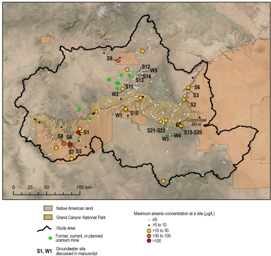
Test results for arsenic in groundwater were available for 652 samples collected from 230 sites in the Grand Canyon region between June 1977 and September 2022. Forty eight of these samples came from wells, and 182 from springs, with most of the springs emerging from the Grand Canyon walls and floor, and drawing their water from a variety of sources above, within, and below the Permian strata that host uranium ore in breccia pipes. Wells are typically located on the plateau above the canyon, and reach depths of between 24 m and 1100 m.
Fifty two of the 230 sample sites had arsenic concentrations of below 1 μm/L, and 202 (88%) had levels below 10 μm/L, considered to be the maximum safe level of exposure. Of the remaining 28 sites, 25 had arsenic levels below 40 μm/L. The highest arsenic concentration was found at Pumpkin Spring, at 875 μm/L. Twenty two of the sites with arsenic concentrations above 10 μm/L are springs discharging into the Colorado River or its tributaries, all but two of these (Saddle Canyon Spring and Fence Fault Left Spring) discharge from the South Rim of the Grand Canyon. The highest arsenic concentrations in springwater are found in the southwest of the study area, in or around the Hualapai Indian Reservation.
At 173 of the sites in the study, data on both water pH and arsenic concentration was available, with the values ranging from pH 3.8 to pH 8.8, with a median of pH 7.7, though only a week correlation between pH and arsenic concentration could be detected. Disolved oxygen concentrations were available for 152 of the study sites; dissolved oxygen concentration ranged from less than 1 mg/L to 11.5 mg/L, with no correlation between dissolved oxygen concentration and dissolved arsenic concentration. Data on the concentration of sulphate (oxidised sulphur) was available for 185 of the sites in the study, ranging from 1.5 mg/L to 3450 mg/L, with a median of 730 mg/L, with no correlation between dissolved sulphates and dissolved arsenic. Dissolved iron concentrations were available for 187 of the study sites, with values ranging from less than 0.2 μg/L to 10 300 μg/L with a median of 4 μg/L, though no correlation could be found between dissolved iron concentration and dissolved arsenic concentrations. Information on total dissolved solids was available for 183 of the study sites, with concentrations ranging from 69 mg/L to 9630 mg/L, with a median of 459 mg/L; no correlation was found between total dissolved solids and dissolved arsenic levels. Data for the age of water (i.e. how long it has spent within the aquifer) is available for 138 of the study sites (based upon the presence of tritium generated by nuclear test explosions), with no correlation found between water age and arsenic concentration.
Unlike all of the previous criteria, no correlation between dissolved uranium and dissolved arsenic in groundwater has previously been reported, however, since concerns have been raised about the possibility of arsenic entering the water supply due to the activities of uranium mines, Tillman et al. also examined this relationship. Information on both uranium and arsenic concentrations were available from 205 sites, with uranium concentrations ranging from m 0.114 μg/L to 231 μg/L, with a median of 3.7 μg/L. No correlation was found between uranium concentration and arsenic concentration.
Travertine is a type of limestone formed around hot mineral springs. In the Grand Canyon area, travertine springs are often associated with faults, and appear to be correlated with high arsenic concentrations. Travertine springs in the area include Pumpkin Spring (which produced the highest dissolved arsenic concentration in the study at 875 μg/L), Travertine Falls Spring (243 μg/L), and Travertine Canyon (100 μg/L), all of which are on the Hualapai Indian Reservation in the western part of the Grand Canyon region. Pumpkin Spring is known to be fault controlled, and considered to discharge waters from the Tapeats Sandstone, although its water is warm, which implies that at least some of it is derived from a deeper source. Fence Spring (arsenic concentration 16.4 μg/L) is another travertine spring located on the Fence Fault Zone, in the eastern part of the Grand Canyon region, and other travertine springs with high arsenic concentrations are known throughout the southwestern United States, , including Mammoth Hot Springs in Yellowstone National Park, and Montezuma Well located in the Verde Valley of Arizona, suggesting a possible mantle-source for arsenic, and groundwater mixing with deep-earth hydrothermal fluids as a mechanism for arsenic to reach surface environments.

The origin of arsenic in water at other springs is less clear. Near Travertine Falls Spring (arsenic concentration 38 μg/L) and Travertine Canyon Spring (35 μg/L) are located close to breccia pipes with elevated levels of uranium, but no fault system appears connected with these pipes. Wooley Spring (arsenic concentration 35.8 μg/L) ) is located north of the Grand Canyon on the Kaibab Indian Reservation and discharges from the Kayenta Formation of the Glen Canyon Group of Jurassic age, which is present in limited northern parts of the study area. The Havasu Spring (arsenic concentration 17 μg/L) is another travertine well, which acts as the primary source of water for the Havasupai Tribe in Supai Village, while Supai Well No. 3 (arsnic consentration 4-12 μg/L) is a 46 m deep alluvium well located two kilometres downstream of Havasu Spring.
Groundwater in Arizona, and the southwestern US in general, is known to be elevated in arsenic compared to the rest of the US. Arsenic levels in well water in the southwest have been shown to exceed the maximum safe level twice as often as water from wells in other parts of the country. This arsenic is thought to be primarily derived from geothermal springs and water passing through volcanic rocks. Groundwater sites in Arizona outside the Grand Canyon region have arsenic levels which range from less than 1 μg/L to 1400 μg/L, with the median being 4 μg/L, with 25% of these sites exceeding the maximum safe level. The highest arsenic concentration in water in Arizona is found at Verde Hot Springs, near the town of Camp Verde in Yavapai County, with an arsenic level of 1400 μg/L, which is again thought to be geothermally influenced, with Pumpkin Spring having the second highest arsenic levels. The highest arsenic level recorded at a well in Arizona came from a 150 m deep well identified as C-19-01 28ADC, near the border with Mexico, and was taken in 1978. Thus, although the Grand Canyon region has high levels of arsenic in its groundwater compared to most of the US, it is actually low compared to the rest of Arizona.
.jpg)
Limited information is available on the groundwater around the uranium mines in the Grand Canyon region, due to a low number of wells in this area. The Pinenut Mine Well is located on the Pinenut Mine site to the north of the Grand Canyon, and sources water from the Mississippian Redwall Limestone. The Pinenut Mine initially opened in 1986, and then closed in 1989, was re-opened in 2009, and closed again as part of the 20-year moratorium on mining imposed in 2013. Arsenic levels in the Pinenut Mine Well were recorded at 6.2 μg/L, in 2009 (prior to the mine re-opening), 13.5 μg/L in 2012 (while the mine was operating), 4.2 μg/L in 2014 (after the mine had closed again), and at 11 μg/L in 2018. The closest well outside the Pinenut Well site, Willow 1 Spring, 7 km to the north of the mine, has been monitored continuously since 2009, due concerns about uranium contamination. This well has recorded arsenic levels between 0.6 μg/L to 3.1 μg/L over that time.
A groundwater mine at the Pinyon Plain Mine (formerly the Canyon Mine) south of the Grand Canyon near the town of Tusayan, which extracts water from the Redwall–Muav aquifer, has been sampled regularly by the USGS since 2003, producing arsenic concentrations ranging from 0.16 μg/L to 0.5 μg/L. An additional well was installed at the same site in 2017 for monitoring purposed, targeting the perched groundwater of the Coconino Sandstone. It was hypothesized that any increase in arsenic in the water caused by mining activity would be detected in this perched groundwater first, but in fact the arsenic levels have fallen steadily since monitoring started, from 4.6 μg/L in 2017 to 0.51 μg/L in 2022.
The Pigeon Mine, to the north of the Grand Canyon, no longer has a well on site, though a monitoring well was installed 4.5 km to the northeast of the site in 2022. This well reaches the Coconino Sandstone aquifer, with a recorded arsenic level of 0.9 μg/L. There are also three natural springs located close to the mine; the Pigeon Spring, 2 km to the east of the mine, Willow Spring 2, about 1.5 km to the southwest of the mine, and Wildband Spring, about 2.2 km southeast of the mine. Pigeon Spring has been monitored continuously since 2016, due to high uranium levels. Arsenic levels at Pigeon Spring have been recorded at between 0.3 μg/L and 2.2 μg/L, while the highest recorded level at Willow Spring 2 was 0.73 μg/L and the highest at Wildbrand Spring was 1 μg/L.
The Orphan Lode Mine (often referred to simply as the Orphan Mine) is an abandoned uranium mine on the South Rim of the Grand Canyon. Groundwater associated with this mine emerges at the Upper Horn Bedrock Spring e at the base of bedrock cliffs near the Redwall-Muav Limestone contact about 500 m down gradient of the Orphan Mine, then is re-absorbed into the rock, emerging at two lower springs further downslope. Uranium levels at the Upper Spring have been recorded as high as s 293 μg/L, but the highest arsenic level recorded was 24.2 μg/L, with the level usually below 10 μg/L. Uranium levels at the lower springs have been recorded in the range 7.2 to 39.3 μg/L, while the range for arsenic is less than 2.5 to 7.7 μg/L.
The abandoned Grandview Mine (also referred to as Last Chance Mine) is a former breccia pipe copper mine on the South Rim of Grand Canyon. The ore targeted here was mostly within the Redwall Limestone, and was known to contain high levels of arsenic. Miners Spring, about 0.6 km southeast of the mine discharges from the Redwall-Muav aquifer. This spring was sampled six times between n 2000 and 2016, producing arsenic levels in the range 17 μg/L to 19.3 μg/L. Another nearby spring, Miners Spring at Trail in Hance Canyon, was sampled once in 1981, producing an arsenic level of 20 μg/L. Two further springs are located further to the southeast; JT Spring being 3.5 km from the mine and Red Canyon Spring about 5 km; JT Spring has produced arsenic levels of 14.4 μg/L, and Red Canyon Spring of 17 μg/L. Two unnamed springs are found about 1.5 km to the west of the Grandview Mine, and have produced arsenic concentrations of 4.8 μg/ L and 1.6 μg/L, respectively.
Many sites within the Grand Canyon region have arsenic levels above what is considered safe in drinking water, although there is no apparent connection to uranium mining, with only a few samples associated with the Pinenut and Grandview mine exceeding safe values, and these not being among the highest levels recorded in the region. However, groundwater in the area is known to move slowly, so there is still the possibility that arsenic contamination of groundwater is happening at these mines, but has yet to be detected.
During mine operations, mine waste is typically piled up within the fenced off mining compound. This is known to be a source of a wide range of pollutants, as rainwater leaches through the spoil, so runoff from such tips is generally contained within a drainage system leading to a lined retention pond. Wind-blown dust can still be a problem, carrying metals and other chemicals to nearby sites, and sometimes entering water systems, although this is unlikely to be a problem for aquifers in the Grand Canyon region, the shallowest of which is 300 m below the surface, and no evidence of recharge from recent groundwater.
Water from aquifers can enter mines and become enriched in metals. This is likely to be a problem for the upper, perched aquifer in the Grand Canyon region; this is typically managed by actively pumping water from the mine into a surface containment pond. The sump pool at the Hermit Mine has produced arsenic levels of 1090 μg/L, while waters within the shaft at Pinyon Plain Mine (which has yet to begin mining uranium) were found to contain 299 μg/L arsenic. As long as water continues to be pumped out of a mine, and the lining containment pool is not breached, this system should prevent metal contaminants from a mine flowing back into aquifers.
The end-of-life process for mines has changed over the time in which mining has occurred in the Grand Canyon region, with the Orphan Lode Mine simply being abandoned at the end of its life, followed by subsequent tightening of regulations over the decades, so that the most recent mine to close, the Pinyon Plain Mine, requires 30 years of groundwater monitoring subsequent to the mine closure. Modern mine closure requires that any water-bearing strata be sealed off, that the mine be sealed off at the surface, and that surface conditions be returned to a clean state. Mine operators typically do this by returning mine spoil to the mine before sealing at the surface.
The contents of breccia pipes tends to be variable, and unevenly distributed, with a mixture of ore and non-ore rocks. However, rocks deemed to be to low in uranium to be worth processing, may still contain high levels of other metals, such as arsenic. These metals may leach out when rainwater passes through mine dumps; stream sediments below the Hack Canyon Mine Complex are known to contain significantly higher levels of arsenic than those above the complex, although these elevated levels do not (at the moment) reach far downstream.
Any similar contamination from a mine on the Coconino Plateau would need to pass through hundreds of metres of rock before reaching the upper, perched aquifer, something highly unlikely given the low rainfall levels in the area, although potentially water could pool within an improperly sealed mine, react with sulphate minerals there to form an acid solution, and allow the freeing and downward movement of metal ions.
After a mine has been closed and sealed, water entering the mine shaft is not usually pumped to the surface. Modern mines are required to seal off aquifers entering mines before abandonment, but there is no actual evidence on how reliable this process is. Furthermore, many mines in the Grand Canyon region were closed down before this requirement was introduced. Any water entering a mine shaft infilled with mine debris would encounter an environment enriched in non-targeted metals, such as arsenic, which might then be carried back into the aquifer. Experimental results suggest that this ought to result in an elevated arsenic content in the water within the aquifer, although not forever, as the supply of metal within the shaft would be finite. This elevated arsenic level would be highest closest to the mine, falling as the water moves further away and is mixed with water that has not passed through the mine.
There is currently no evidence that elevated levels of arsenic originating at breccia pipe mines are moving through aquifers in the Grand Canyon region. However, the low rate at which water moves in the region could mean that any such movement would not be detected for decades after it began, meaning that even the 30 years of groundwater monitoring required at closing mines may not be sufficient to detect any problems.
The Grand Canyon region is home to some of the world's most productive uranium mines, but concern about the environmental impact of this industry led to a 20 year moratorium on new mining activities being imposed in 2012. Since this time, the United States Geological Survey has carried out extensive environmental monitoring in the region, aimed at enabling future legislators to make informed decisions about mining activity in the region. Current data suggests that high levels of arsenic are found at many sites in this area, but that this does not appear to be related to mining activity. However, the data at the current time is not sufficient to enable the possibility of mining causing elevated arsenic levels within aquifers, requiring the monitoring program to be continued.
See also...



Follow Sciency Thoughts on Facebook.
Follow Sciency Thoughts on Twitter.