Showing posts with label Aquifers. Show all posts

Sunday, 25 June 2023

Seeking the source of arsenic in groundwater in the Grand Canyon region, Arizona.

The Grand Canyon is an internationally renowned tourist attraction, drawing visitors from all over the world. It is also viewed as a sacred place by many Native Americans, many of whom make their home there. The Colorado River has been carving out the canyon for over 3 million years, and provides a major source of water for about 40 million people in the United States and Mexico. However, in the area immediately around the Grand Canyon, the water needs of both residents and visitors is almost entirely met from groundwater. This water supply is threatened by a warming climate, as this is associated with a drying environment locally, lowering the rate at which groundwater reserves are recharged. The Grand Canyon region is also home to some of the richest deposits of uranium in the US. Concerns about the impact of this industry on the local water supply led to a 20-year moratorium on new mining activity being put into place in 2012, since which time the United States Geological Survey has been carrying out extensive monitoring of the relationship between mining and water supplies in the region, with the objective of enabling future policy-makers to make informed decisions about uranium mining around the Grand Canyon.

While it is obvious that uranium entering the water supply would be a bad thing, other metals present in uranium ore deposits are probably a greater threat to Human health. Arsenic in particular, while present to an extent in all soils, rocks, and groundwater supplies, is particularly of concern in the Grand Canyon region, and is known to be present in the minerals of the breccia pipe deposits targeted by uranium miners in the area. Elevated levels of arsenic in drinking water are associated with a range of health problems, including skin lesions and cancer of the lung, bladder, kidney, and liver, and both the United States Environmental Protection Agency and World Health Organization set the maximum safe level of arsenic in water supplies at 10 μm/L, whereas the equivalent level for uranium is 30 μm/L.

In a paper published in the journal PLoS Water on 14 June 2023, Fred Tillman of the Arizona Water Science Center of the United States Geological Survey, Kimberly Beisner of the New Mexico Water Science Center of the United States Geological Survey, and Casey Jones of the South Atlantic Water Science Center of the United States Geological Survey, present an analysis of the arsenic content of groundwater in the Grand Canyon area, and its relationship to potential sources, including the mining of uranium.

Study area within the western United States (upper panel) and detail of study area showing Native American land, uranium mines, withdrawal areas, and breccia pipes (lower panel). Tillman et al. (2023).

The Grand Canyon region is sparsely populated, and therefore has a limited number of water extraction wells, something which makes it difficult to assess the extent of the aquifers these wells target. In the absence of such data, topographic features are assumed to deliminate the extent of these aquifers. Tillman et al. looked at an area containing watersheds flowing into the Colorado River between Lees Ferry to the east and the Grand Wash Cliffs to the west. There are known to be two groundwater systems in this area. The shallower of these is a perched aquifer 300 m below the plateau surface, which runs through the in the Permian-age Kaibab Formation, Toroweap Formation, and Coconino Sandstone, which is thought only to be present in the area immediately around the Grand Canyon. The deeper system is about 1 km beneath the plateau surface, and runs through the Mississippian-age Redwall Limestone, the Devonian-age Temple Butte Formation, and the underlying Cambrian-age Muav Limestone of the Tonto Group, which is thought to be present over a much wider area, except where the water-bearing units have been eroded away by canyon formation.

Uranium in the Grand Canyon has been mined from breccia pipes (cave systems, often of volcanic origin, filled in by rock debris, and usually cemented by mineral deposition). These breccia pipes cut through multiple strata in the region, with uranium accumulations generally being found where the pipes cut through the Permian Coconino Sandstone, Hermit Formation, and Esplanade Sandstone. Large scale uranium mining here began in the 1950s, at the Orphan Mine on the southern rim of the Grand Canyon, and there are currently two active mines, as well as eleven former mines targeting breccia pipes within the region. These mines frequently crossed the upper, perched groundwater aquifer, but stopped hundreds of metres short of reaching the lower aquifer. While these mines targeted uranium, the ore bodies also include trace amounts of antimony, arsenic, barium, cadmium, cobalt, copper, mercury, molybdenum, nickel, lead, silver, strontium, vanadium, and zinc; all of these are also found in other rocks in the area, but at much lower concentrations.

Lithology and mine features at breccia-pipe uranium mining sites in the Grand Canyon region. Tillman et al. (2023).

Arsenic is a fairly common element at the Earth's surface, found in a wide variety of rocks and minerals, although rarely at concentrations high enough to cause problems. In the Grand Canyon are it is found in most of the sedimentary rocks at levels of about 5-10 mg/kg, typically at the lower end of this range in sandstones and at the upper end in clays and shales, where it binds to oxides, sulphides, and organic materials. Carbonate rocks tend to have much lower concentrations. A study which looked at over 700 soil samples from the Coconino Plateau in northern Arizona, found that while the average arsenic concentration was less than 10 mg/kg, the maximum was about 70 mg/kg, and a study of seventeen surface-collected aquifer-related rocks from the Grand Canyon found that only two has arsenic concentrations of less than 20 mg/kg, with the maximum being 28.9 mg/kg in the Muav Limestone. Arsenic concentrations from the breccia pipe structures are also known to be significantly higher than in the surrounding rocks, making these structures a potential source of elevated arsenic levels in groundwater, particularly if they are disturbed. Arsenic is usually found at its highest concentrations in sulphide minerals, such as the ore arsenopyrite (iron arsenic sulphide), which, along with other arsenic sulphide minerals, is found within the breccia pipes. Samples obtained from drill-cores and mine waste derived from the breccia pipes show much higher arsenic levels, as high as 5060 mg/kg in waste rock from the Pigeon Mine, 1980 mg/kg in waste from the Kanab North Mine, 15 300 mg/kg in a drill core from the Hack II Mine, and 105 000 mg/kg in the Pineon Plane Mine deposits.

Arsenic from rock can easily become dissolved in groundwater under the right concentrations, however, it is difficult to make direct predictions about the persistence and movement of arsenic in groundwater, as it is sensitive to changes in pH, oxidation-reduction potential, and the presence of iron oxides, with the effect that the amount of dissolved arsenic within an aquifer can vary considerably over quite short distances. Troublingly, unlike most heavy metals, arsenic can become mobilised in water at pH levels between 6.5 and 8.5, under both oxidising and reducing conditions. Arsenic can form different aqueous ions at different pH levels; between pH 3 and pH 7 it will form monovalent arsenate anions, at pH7-11 it forms divalent arsenic, while under mildly reducing conditions it forms uncharged arsenite ions. Arsenite is the most mobile of these forms, while arsenate is the most easily resorbed onto rocks, but all will precipitate out or redissolve in response to pH or radox potential of the water. Studies in other areas of the US have suggested that arsenic is most prone to dissolving in groundwater when conditions are oxic and the pH is higher than 7.

High arsenic levels in groundwater are generally associated with aquifers with favourable geochemical conditions, geothermal springs, or mining activities. Arsenic can be a significant portion of magma (and volcanic ash), and thus is often concentrated in geothermal water flowing through volcanic systems. Thus, many hot springs in the Yellowstone National Park have been shown to have arsenic concentrations as high as 10 mg/L. Clearly, arsenic-rich rocks are a particularly good source of arsenic ions, but under the right conditions, aquifer waters can become enriched in arsenic even when the rocks they are flowing through are not particularly enriched in arsenic. In the Bengal Basin of Bangladesh disolved arsenic in aquifers can reach as high as 3.2 mg/L, despite the sediments through which these waters flow having arsenic levels of less than 2-20 mg/L. High residency time of water within an aquifer (i.e. 'old water') also appears to help arsenic build up within the water, particularly if the water has either a high pH or a neutral pH under reducing conditions. Arsenic levels in water can also rise when the water is exposed to mine ores or waste rock, particularly where sulphide-rocks are becoming oxidised following disturbance due to Human activities.

Data on the concentration of arsenic in water samples from springs and wells in the e Grand Canyon region were obtained from the USGS National Water Information System database, with additional data provided by a USGS–National Park Service sampling partnership which ran from 2016 through 2017, and involved Grand Canyon National Park staff collecting samples from spring locations in the park, which were then processed at USGS laboratories.

Eighty seven replicate pairs of samples were available (replicate pairs are environmental samples collected as close together in time and space as is possible, to ensure their reliability; in this instance all replicate sample pairs produced a variation in arsenic concentration of less than 1.2 μm/L). Of these, seven pairs produced arsenic levels in excess of the recommended 10 μm/L. Analyses of these pairs for uranium, sulphide levels, and total dissolved solids, produced similar levels of matching, suggesting that the analyses being used for these was reliable, but testing for iron produced quite high variations between samples when the iron concentration was below about 100 μm/L.

Test results for arsenic in groundwater were available for 652 samples collected from 230 sites in the Grand Canyon region between June 1977 and September 2022. Forty eight of these samples came from wells, and 182 from springs, with most of the springs emerging from the Grand Canyon walls and floor, and drawing their water from a variety of sources above, within, and below the Permian strata that host uranium ore in breccia pipes. Wells are typically located on the plateau above the canyon, and reach depths of between 24 m and 1100 m. 

Fifty two of the 230 sample sites had arsenic concentrations of below 1 μm/L, and 202 (88%) had levels below 10 μm/L, considered to be the maximum safe level of exposure. Of the remaining 28 sites, 25 had arsenic levels below 40 μm/L. The highest arsenic concentration was found at Pumpkin Spring, at 875 μm/L. Twenty two of the sites with arsenic concentrations above 10 μm/L are springs discharging into the Colorado River or its tributaries, all but two of these (Saddle Canyon Spring and Fence Fault Left Spring) discharge from the South Rim of the Grand Canyon. The highest arsenic concentrations in springwater are found in the southwest of the study area, in or around the Hualapai Indian Reservation.
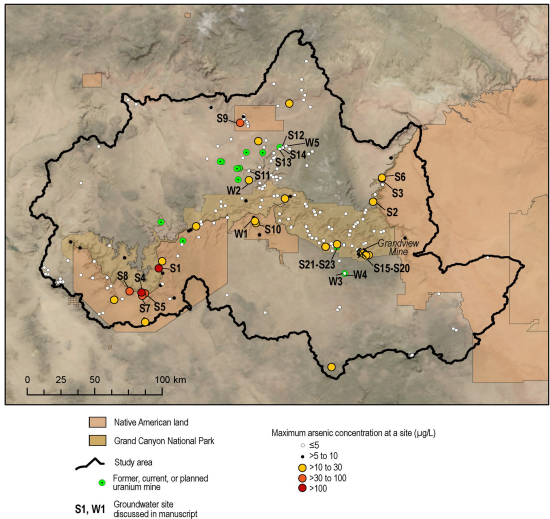
Map of the maximum arsenic concentration observed at 230 groundwater sites in the Grand Canyon study area. Tillman et al. (2023). 

At 173 of the sites in the study, data on both water pH and arsenic concentration was available, with the values ranging from pH 3.8 to pH 8.8, with a median of pH 7.7, though only a week correlation between pH and arsenic concentration could be detected. Disolved oxygen concentrations were available for 152 of the study sites; dissolved oxygen concentration ranged from less than 1 mg/L to 11.5 mg/L, with no correlation between dissolved oxygen concentration and dissolved arsenic concentration. Data on the concentration of sulphate (oxidised sulphur) was available for 185 of the sites in the study, ranging from 1.5 mg/L to 3450 mg/L, with a median of 730 mg/L, with no correlation between dissolved sulphates and dissolved arsenic. Dissolved iron concentrations were available for 187 of the study sites, with values ranging from less than 0.2 μg/L to 10 300 μg/L with a median of 4 μg/L, though no correlation could be found between dissolved iron concentration and dissolved arsenic concentrations. Information on total dissolved solids was available for 183 of the study sites, with concentrations ranging from 69 mg/L to 9630 mg/L, with a median of 459 mg/L; no correlation was found between total dissolved solids and dissolved arsenic levels. Data for the age of water (i.e. how long it has spent within the aquifer) is available for 138 of the study sites (based upon the presence of tritium generated by nuclear test explosions), with no correlation found between water age and arsenic concentration.

Unlike all of the previous criteria, no correlation between dissolved uranium and dissolved arsenic in groundwater has previously been reported, however, since concerns have been raised about the possibility of arsenic entering the water supply due to the activities of uranium mines, Tillman et al. also examined this relationship. Information on both uranium and arsenic concentrations were available from 205 sites, with uranium concentrations ranging from m 0.114 μg/L to 231 μg/L, with a median of 3.7 μg/L. No correlation was found between uranium concentration and arsenic concentration. 

Travertine is a type of limestone formed around hot mineral springs. In the Grand Canyon area, travertine springs are often associated with faults, and appear to be correlated with high arsenic concentrations. Travertine springs in the area include Pumpkin Spring (which produced the highest dissolved arsenic concentration in the study at 875 μg/L), Travertine Falls Spring (243 μg/L), and Travertine Canyon (100 μg/L), all of which are on the Hualapai Indian Reservation in the western part of the Grand Canyon region. Pumpkin Spring is known to be fault controlled, and considered to discharge waters from the Tapeats Sandstone, although its water is warm, which implies that at least some of it is derived from a deeper source. Fence Spring (arsenic concentration 16.4 μg/L) is another travertine spring located on the Fence Fault Zone, in the eastern part of the Grand Canyon region, and other travertine springs with high arsenic concentrations are known throughout the southwestern United States, , including Mammoth Hot Springs in Yellowstone National Park, and Montezuma Well located in the Verde Valley of Arizona, suggesting a possible mantle-source for arsenic, and groundwater mixing with deep-earth hydrothermal fluids as a mechanism for arsenic to reach surface environments.

Pumpkin Spring on the Colorado River in the Grand Canyon, a mineral pool with an arsnic concentration of 875 μg/L. Atlas Obscura.

The origin of arsenic in water at other springs is less clear. Near Travertine Falls Spring (arsenic concentration 38 μg/L) and Travertine Canyon Spring (35 μg/L) are located close to breccia pipes with elevated levels of uranium, but no fault system appears connected with these pipes. Wooley Spring (arsenic concentration 35.8 μg/L) ) is located north of the Grand Canyon on the Kaibab Indian Reservation and discharges from the Kayenta Formation of the Glen Canyon Group of Jurassic age, which is present in limited northern parts of the study area. The Havasu Spring (arsenic concentration 17 μg/L) is another travertine well, which acts as the primary source of water for the Havasupai Tribe in Supai Village, while Supai Well No. 3 (arsnic consentration 4-12 μg/L) is a 46 m deep alluvium well located two kilometres downstream of Havasu Spring.

Groundwater in Arizona, and the southwestern US in general, is known to be elevated in arsenic compared to the rest of the US. Arsenic levels in well water in the southwest have been shown to exceed the maximum safe level twice as often as water from wells in other parts of the country. This arsenic is thought to be primarily derived from geothermal springs and water passing through volcanic rocks. Groundwater sites in Arizona outside the Grand Canyon region have arsenic levels which range from less than 1 μg/L to 1400 μg/L, with the median being 4 μg/L, with 25% of these sites exceeding the maximum safe level. The highest arsenic concentration in water in Arizona is found at Verde Hot Springs, near the town of Camp Verde in Yavapai County, with an arsenic level of 1400 μg/L, which is again thought to be geothermally influenced, with Pumpkin Spring having the second highest arsenic levels. The highest arsenic level recorded at a well in Arizona came from a 150 m deep well identified as C-19-01 28ADC, near the border with Mexico, and was taken in 1978. Thus, although the Grand Canyon region has high levels of arsenic in its groundwater compared to most of the US, it is actually low compared to the rest of Arizona.

Verde Hot Springs, near the town of Camp Verde in Yavapai County, with an arsenic level of 1400 μg/L. Greg Walters/Wikimedia Commons.

Limited information is available on the groundwater around the uranium mines in the Grand Canyon region, due to a low number of wells in this area. The Pinenut Mine Well is located on the Pinenut Mine site to the north of the Grand Canyon, and sources water from the Mississippian Redwall Limestone. The Pinenut Mine initially opened in 1986, and then closed in 1989, was re-opened in 2009, and closed again as part of the 20-year moratorium on mining imposed in 2013. Arsenic levels in the Pinenut Mine Well were recorded at 6.2 μg/L, in 2009 (prior to the mine re-opening), 13.5 μg/L in 2012 (while the mine was operating), 4.2 μg/L in 2014 (after the mine had closed again), and at 11 μg/L in 2018. The closest well outside the Pinenut Well site, Willow 1 Spring, 7 km to the north of the mine, has been monitored continuously since 2009, due concerns about uranium contamination. This well has recorded arsenic levels between 0.6 μg/L to 3.1 μg/L over that time.

A groundwater mine at the Pinyon Plain Mine (formerly the Canyon Mine) south of the Grand Canyon near the town of Tusayan, which extracts water from the Redwall–Muav aquifer, has been sampled regularly by the USGS since 2003, producing arsenic concentrations ranging from 0.16 μg/L to 0.5 μg/L. An additional well was installed at the same site in 2017 for monitoring purposed, targeting the perched groundwater of the Coconino Sandstone. It was hypothesized that any increase in arsenic in the water caused by mining activity would be detected in this perched groundwater first, but in fact the arsenic levels have fallen steadily since monitoring started, from 4.6 μg/L in 2017 to 0.51 μg/L in 2022.

The Pigeon Mine, to the north of the Grand Canyon, no longer has a well on site, though a monitoring well was installed 4.5 km to the northeast of the site in 2022. This well reaches the Coconino Sandstone aquifer, with a recorded arsenic level of 0.9 μg/L. There are also three natural springs located close to the mine; the Pigeon Spring, 2 km to the east of the mine, Willow Spring 2, about 1.5 km to the southwest of the mine, and Wildband Spring, about 2.2 km southeast of the mine. Pigeon Spring has been monitored continuously since 2016, due to high uranium levels. Arsenic levels at Pigeon Spring have been recorded at between 0.3 μg/L and 2.2 μg/L, while the highest recorded level at Willow Spring 2 was 0.73 μg/L and the highest at Wildbrand Spring was 1 μg/L.

The Orphan Lode Mine (often referred to simply as the Orphan Mine) is an abandoned uranium mine on the South Rim of the Grand Canyon. Groundwater associated with this mine emerges at the Upper Horn Bedrock Spring e at the base of bedrock cliffs near the Redwall-Muav Limestone contact about 500 m down gradient of the Orphan Mine, then is re-absorbed into the rock, emerging at two lower springs further downslope. Uranium levels at the Upper Spring have been recorded as high as s 293 μg/L, but the highest arsenic level recorded was 24.2 μg/L, with the level usually below 10 μg/L. Uranium levels at the lower springs have been recorded in the range 7.2 to 39.3 μg/L, while the range for arsenic is less than 2.5 to 7.7 μg/L. 

The abandoned Grandview Mine (also referred to as Last Chance Mine) is a former breccia pipe copper mine on the South Rim of Grand Canyon. The ore targeted here was mostly within the Redwall Limestone, and was known to contain high levels of arsenic. Miners Spring, about 0.6 km southeast of the mine discharges from the Redwall-Muav aquifer. This spring was sampled six times between n 2000 and 2016, producing arsenic levels in the range 17 μg/L to 19.3 μg/L. Another nearby spring, Miners Spring at Trail in Hance Canyon, was sampled once in 1981, producing an arsenic level of 20 μg/L. Two further springs are located further to the southeast; JT Spring being 3.5 km from the mine and Red Canyon Spring about 5 km; JT Spring has produced arsenic levels of 14.4 μg/L, and Red Canyon Spring of 17 μg/L. Two unnamed springs are found about 1.5 km to the west of the Grandview Mine, and have produced arsenic concentrations of 4.8 μg/ L and 1.6 μg/L, respectively.

Many sites within the Grand Canyon region have arsenic levels above what is considered safe in drinking water, although there is no apparent connection to uranium mining, with only a few samples associated with the Pinenut and Grandview mine exceeding safe values, and these not being among the highest levels recorded in the region. However, groundwater in the area is known to move slowly, so there is still the possibility that arsenic contamination of groundwater is happening at these mines, but has yet to be detected. 

During mine operations, mine waste is typically piled up within the fenced off mining compound. This is known to be a source of a wide range of pollutants, as rainwater leaches through the spoil, so runoff from such tips is generally contained within a drainage system leading to a lined retention pond. Wind-blown dust can still be a problem, carrying metals and other chemicals to nearby sites, and sometimes entering water systems, although this is unlikely to be a problem for aquifers in the Grand Canyon region, the shallowest of which is 300 m below the surface, and no evidence of recharge from recent groundwater. 

Water from aquifers can enter mines and become enriched in metals. This is likely to be a problem for the upper, perched aquifer in the Grand Canyon region; this is typically managed by actively pumping water from the mine into a surface containment pond. The sump pool at the Hermit Mine has produced arsenic levels of 1090 μg/L, while waters within the shaft at Pinyon Plain Mine (which has yet to begin mining uranium) were found to contain 299 μg/L arsenic. As long as water continues to be pumped out of a mine, and the lining containment pool is not breached, this system should prevent metal contaminants from a mine flowing back into aquifers.

The end-of-life process for mines has changed over the time in which mining has occurred in the Grand Canyon region, with the Orphan Lode Mine simply being abandoned at the end of its life, followed by subsequent tightening of regulations over the decades, so that the most recent mine to close, the Pinyon Plain Mine, requires 30 years of groundwater monitoring subsequent to the mine closure. Modern mine closure requires that any water-bearing strata be sealed off, that the mine be sealed off at the surface, and that surface conditions be returned to a clean state. Mine operators typically do this by returning mine spoil to the mine before sealing at the surface. 

The contents of breccia pipes tends to be variable, and unevenly distributed, with a mixture of ore and non-ore rocks. However, rocks deemed to be to low in uranium to be worth processing, may still contain high levels of other metals, such as arsenic. These metals may leach out when rainwater passes through mine dumps; stream sediments below the Hack Canyon Mine Complex are known to contain significantly higher levels of arsenic than those above the complex, although these elevated levels do not (at the moment) reach far downstream. 

Any similar contamination from a mine on the Coconino Plateau would need to pass through hundreds of metres of rock before reaching the upper, perched aquifer, something highly unlikely given the low rainfall levels in the area, although potentially water could pool within an improperly sealed mine, react with sulphate minerals there to form an acid solution, and allow the freeing and downward movement of metal ions. 

After a mine has been closed and sealed, water entering the mine shaft is not usually pumped to the surface. Modern mines are required to seal off aquifers entering mines before abandonment, but there is no actual evidence on how reliable this process is. Furthermore, many mines in the Grand Canyon region were closed down before this requirement was introduced. Any water entering a mine shaft infilled with mine debris would encounter an environment enriched in non-targeted metals, such as arsenic, which might then be carried back into the aquifer. Experimental results suggest that this ought to result in an elevated arsenic content in the water within the aquifer, although not forever, as the supply of metal within the shaft would be finite. This elevated arsenic level would be highest closest to the mine, falling as the water moves further away and is mixed with water that has not passed through the mine.

There is currently no evidence that elevated levels of arsenic originating at breccia pipe mines are moving through aquifers in the Grand Canyon region. However, the low rate at which water moves in the region could mean that any such movement would not be detected for decades after it began, meaning that even the 30 years of groundwater monitoring required at closing mines may not be sufficient to detect any problems.

The Grand Canyon region is home to some of the world's most productive uranium mines, but concern about the environmental impact of this industry led to a 20 year moratorium on new mining activities being imposed in 2012. Since this time, the United States Geological Survey has carried out extensive environmental monitoring in the region, aimed at enabling future legislators to make informed decisions about mining activity in the region. Current data suggests that high levels of arsenic are found at many sites in this area, but that this does not appear to be related to mining activity. However, the data at the current time is not sufficient to enable the possibility of mining causing elevated arsenic levels within aquifers, requiring  the monitoring program to be continued.

See also...

Follow Sciency Thoughts on Facebook.

Follow Sciency Thoughts on Twitter.


Sunday, 18 October 2015

Flash flooding brings chaos to South California.

Many areas of southern California are recovering after a series of thunderstorms caused flash flooding across parts of Los Angeles, San Luis Obispo, Santa Barbara, and Ventura counties on Thursday 15 and Friday 16 October 2015. The flooding triggered mudslides and landslips in many areas, blocking roads and trapping people in vehicles as well as causing damage to homes and other properties. Landslides are a common problem after severe weather events, as excess pore water pressure can overcome cohesion in soil and sediments, allowing them to flow like liquids. Approximately 90% of all landslides are caused by heavy rainfall. No loss of Human life has been reported following the incident, but farms in many areas are reporting losses of Cattle and other livestock.

A pickup truck trapped by a mudslide on State Route 58 close to the Mojave Desert. CBS.

Flash floods are a common problem in southern California (and other areas with a dry climate) as protracted periods of dry weather can cause topsoil to dry out completely, making it vulnerable to being blown away by the wind. When rain does arrive it then falls on exposed bedrock, which is much less absorbent, triggering flash flooding as the water escapes over the surface of the ground rather than sinking into it. These floods wash away more topsoil, making the problem progressively worse over time. In Los Angeles this is reflected in the concrete channel which contains the Los Angeles River; a spectacular concrete structure which contains for much of the year only a tiny trickle of water, but which was built after a series of devastating floods in the early twentieth century.

Los Angeles River and flood control channel. US Army Corps of Engineers.

The floods come after several months of extreme drought in southern California, that has killed of plantlife in many normally non-arid areas, weakening the network of roots that tends to protect hillsides against collapse, and hardening the soil surface, making flash flooding more likely. It has been suggested by some observers that this may be the beginning of a much wetter climate phase associated with this years El Niño weather system over the southern Pacific Ocean, a phenomenon that typically brings high levels of rainfall to the southwest United States, though if this is the case then the weather has arrived dramatically early, as the increase in storm activity associated with El Niño does not usually begin in California till December.

Vehicle trapped in mud in Green Valley, California. KABC-TV/AP.

The El Niño is the warm phase of a long-term climatic oscillation affecting the southern Pacific, which can influence the climate around the world. The onset of El Niño conditions is marked by a sharp rise in temperature and pressure over the southern Indian Ocean, which then moves eastward over the southern Pacific. This pulls rainfall with it, leading to higher rainfall over the Pacific and lower rainfall over South Asia. This reduced rainfall during the already hot and dry summer leads to soaring temperatures in southern Asia, followed by a rise in rainfall that often causes flooding in the Americas and sometimes Africa. Worryingly climatic predictions for the next century suggest that global warming could lead to more frequent and severe El Niño conditions, extreme weather conditions a common occurrence.

Vehicles trapped by a mudslide on California Highway 58 in the Mojave Desert. Mark Ralston/AFP/Getty Images.

Hopes that the onset of high rainfall may bring an end to California's drought are also likely to be thwarted by the low state of reserves in the state's aquifers (underground water resources) which have been heavily over-exploited for industry and agriculture for some years. Such aquifers are slow to refill, with the effect that even a particularly long and wet Californian winter is unlikely to have much of an effect without a change to water-use policies in the state.

See also...

The United States Geological Survey recorded a Magnitude 3.4 Earthquake at a depth of about 12 km beneath the Gardena district of Los Angeles, California, slightly before 10.00 pm local time on Saturday 6 June 2015 (slightly before 5.00 am on Sunday 7...

Six homes and five businesses have reportedly suffered severe damage after a tornado touched down in the town of Hawthorne in Mineral County, Nevada, at about 3.15 pm local time on Friday 5 June 2015.  The storm created a trail of damage through the town...


A Sheridan Police Department SUV was swallowed by a sinkhole that opened up beneath it unexpectedly at about 2.15 am local time on Friday 5 June 2015. The single occupant of the vehicle, police sergeant Greg Miller, was able to craw out of the hole, which was...


Follow Sciency Thoughts on Facebook.

Sunday, 28 June 2015

Understanding current flows in hydrothermal vents.


Hydrothermal vents are areas on the sea floor where water warmed by the heat of the Earth’s interior escapes into the wider ocean. These waters contain high levels of dissolved minerals and nutrients rare in the wider oceans, and therefore support unique ecosystems able to survive without any input of solar energy. The most extreme examples of hydrothermal vents are the black smokers found around volcanically active ocean ridges. These vents produce water with temperatures reaching hundreds of degrees centigrade, kept liquid only by the high pressures present on the ocean floor, and opaque due to the high levels of minerals present. However hydrothermal vents are also present on areas of the ocean floor far from the active ridges, or any other form of volcanic influence, apparently emitting water that has been transported hundreds of kilometres beneath the ocean floor, which is far harder to explain.

In a paper published in the journal Nature Communications on 26 June 2015, Dustin Winslow of the Earth and Planetary Sciences Department at the University of California Santa Cruz and Andrew Fisher of the Earth and Planetary Sciences Department and Institute for Geophysics and Planetary Physics at the University of California Santa Cruz describe the results of a computer model of water flows supplying water to hydrothermal vents on the ocean floor, based upon observations of vents around the Juan de Fuca Ridge off the northwest coast of North America, which appears to solve the mystery of water supply to distant hydrothermal vents.

Marine sediments tend to be very rich in clay minerals, and are thus effectively impermeable to the flow of water. However the volcanic rocks that lay beneath these sediments tend to be highly porous, allowing the free transport of water. Therefore areas of exposed rock can act as either entrances or exits for water moving through subsurface aquifers, which are isolated from the general ocean in areas where the volcanic bedrock is covered by sediments. Observational evidence from around the Juan de Fuca Ridge suggest that whether an area of exposed volcanic rock serves as an entrance or exit to the aquifer is driven by the size of the exposure rather than other factors, such as proximity to volcanic heating, or the temperature or current speeds of the water passing over the entrances, with hydrothermal vents (i.e. areas where water exits from the aquifers) always occurring from exposed rocks with limited areas.

Geometry and configuration of 3D domains. Domains represent a section of upper ocean crust, oriented with the long-axis parallel to the spreading ridge, consistent with conditions at a field site on the eastern flank of the Juan de Fuca Ridge. A conductive volcanic rock section (red, lower permeability) is overlain by a crustal aquifer (orange, higher permeability) and marine sediments (blue, lower permeability) and two volcanic rock outcrops penetrate through the sediment (light blue). Heat is applied to the base, following a lithospheric cooling trend. The sides and base are no-fluid flow boundaries, and the top is free flow (fluid and heat) with pressure varying as a function of seafloor depth. Winslow & Fisher (2015).

Winslow and Fisher simulated flows between outcrops of different sizes, through subsurface aquifers being heated gently but evenly and constantly from below. They initially tried modelling systems where the current was present at the start of the experiment, on the basis that establishing a system and maintaining it are not the same, but found that even where no current was present at the outset of the experiment, a current flow from the larger opening to the smaller was quickly established.

Larger areas of permeable rock exposure allow both the entrance and exit of water across their surface, whereas smaller openings allow movement in only one direction. As warmer water rises from the vent into the water column warm water exiting from the vent quickly comes to dominate the flow of water at smaller vents, particularly if these are raised above the surrounding area (i.e. sticking up through the mud). This in turn leads to a draw on the waters of the aquifer, effectively pulling water through from the larger areas of exposure.

Simulation results at dynamic steady state. This simulation, showing one quarter of the domain illustrated in the top figure, has one large outcrop and one small outcrop. Domain colours show domain temperatures, including influence of rolling/mixed convection in basement aquifer and thermal influence of recharging/discharging outcrops. Inset diagrams show fluid flow vectors within and around outcrops (length indicates flow rate), with vectors plotted on a natural-log scale, the longest vector (exiting the top of the discharging outcrop) corresponding to a flow rate of 14m per year. Fluid flow through the sediment is so slow that it would generate no detectable thermal or geochemical anomalies. Vertical exaggeration (VE) of main image is times three; VE of inset images is times two. Winslow & Fisher (2015).

Hydrothermal vents are thought to account for about 25% of heat loss from the Earth’s interior, which if correct suggests that a very large amount of water is exiting from such vents every day. Despite this such vents are notoriously hard to find, with efforts to locate them with satellites having been largely inconclusive, and most known vents having been discovered by exploratory missions involving deep-sea submersibles. Winslow and Fisher’s findings suggest that a preference for such vents occurring on smaller outcrops is a genuine natural phenomenon, rather than a product of the observation methods being used. This would explain the difficulty in finding such vents using satellites, as very small discrete vents, no matter how numerous, would fall below the area/size at which it was possible to detect them using remote sensing technology.

See also…

A seismic monitoring system beneath the northeast Pacific operated by the Ocean Observatories Initiative has detected a probable eruption on Axial Seamount, a submarine volcano roughly 480 km off the coast of Oregon. The network has detected...


Hydrothermal vents in the deep oceans are colonized by a broad array of invertebrates that have symbiotic relationships with chemotropic Bacteria. These Bacteria are able to derive energy from chemicals discharged by the vents, providing a base for ecosystems entirely separated from the light of the Sun. Not all...


Deep sea hydrothermal vents are unique ecosystems where the food chain is based not upon the photosynthetic activity of plants or algae, but rather of chemotrophic bacteria that gain their energy from...


Follow Sciency Thoughts on Facebook.

Tuesday, 5 May 2015

Groundwater systems beneath the McMurdo Dry Valleys of Antarctica.


The McMurdo Dry Valleys are a largely ice-free region of Antarctica on the Ross Sea coast, discovered by Robert Scott in the early twentieth century. The valleys contain a series of lakes, lacking surface connections and often separated by glaciers. Most of the ground in the valleys is frozen, though near-surface groundwater seeps and tracks are present in the upper 70 cm of soil, which are typically extremely saline, enabling them to remain liquid at temperatures below zero degrees centigrade. Deeper saline waterways are also predicted in the Valleys, but several attempts at finding them with boreholes by the Antarctic Dry Valley Drilling Project in the 1970s were unsuccessful.

The most famous feature of the Valleys is Blood Falls, an intermittent outpouring of highly saline, iron-rich water from Taylor Glacier into Lake Bonney, which stains the surface of the glacier a deep crimson. This is thought to be caused to by the weight of the glacier pressing down on deepsubsurface waters and forcing them to migrate upwards. The waters of Blood Falls are known to host a rich microbial community, which probably help to weather iron from the bedrock metabolically. The water of blood falls is sufficiently saline to remain a liquid a -6˚C at surface pressures, and therefore at cooler temperatures in the higher pressure conditions beneath the glacier.

Blood Falls, McMurdo Dry Valleys, Antarctica. Peter Rejcek/National Science Foundation/Wikipedia.

In a paper published in the journal Nature Communications on 28 April 2015, Jill Mikucki of the Department of Microbiology at the University ofTennessee, Knoxville, Esben Auken of the Department of Geosciences at AarhusUniversity, Slawek Tulaczyk of the Department of Earth and Planetary Sciences at the University of California, Santa Cruz, Ross Virginia of the Environmental StudiesProgram at Dartmouth College, Cyril Schamper of Sorbonne Universités, Kurt Sørensen, also of the Department of Geosciences at Aarhus University, Peter Doran of the Departmentof Geology and Geophysics at Louisiana State University, Hilary Dugan of the Departmentof Earth and Environmental Sciences at the University of Illinois at Chicago and Neil Foley, also of the Department of Earth and Planetary Sciences at the University of California, Santa Cruz describe the results of a study of deep groundwater in the McMurdo Dry Valleys using airborne electromagnetic systems to measure the resistivity of deep sediment layers.

Mikuckiet al. used a system called SkyTEM, which uses a high-powered transmitter loop carried by helicopter to induce subsurface electromagnetic currants. Similar systems have previously been used to map permafrost and buried ice features in the Alaskan Arctic and on Livingstone Island off the coast of Anartica.

Map of Taylor Valley in Antarctica. (a) Map of major lakes, glaciers and Antarctic Dry Valley Drilling Project (DVDP) boreholes in Taylor Valley, Antarctica. Dotted red line indicates the location of the Lake Fryxell DVDP geophysical survey. (b) Airborne electromagnetic flight lines in green with survey lines for which data were processed shown in yellow. Terrain surveyed in this paper is highlighted in red. Dashed line indicates regions where higher-resolution surveys were conducted in the Bonney and Fryxell Basins. Red circle indicates the location of the example SkyTEM sounding. Mikucki et al.(2015).

Mikucki et al. were able to differentiate buried brine systems, which have very low resistivities, in the order of 10–100 Ωm, from buried ice, which has a very high resistivity, in the order of 500–20,000Ωm. This enabled them to detect two extensive brine systems in the McMurdo Dry Valleys, one beneath Taylor Glacier and the upper Lake Bonney Basin and one beneath Lower Taylor Valley and the Lake Fryxell Basin.

Resistivity cross-section for the length of the Taylor Valley. Resistivity profile along the length of the Taylor Valley. Low resistivities near McMurdo Sound to Lake Hoare interpreted as hydrological connectivity of brine in sediments extending from the coastal margin inland and beneath the Canada Glacier. To the west, resistivities increase below Suess Glacier and again towards Lake Bonney. In the Bonney Basin, low-resistivity patterns suggest connectivity of brine-rich sediments below the Taylor Glacier with proglacial Lake Bonney at the glacier terminus and near the location of Blood Falls. Mikucki et al.(2015).

The McMurdo Dry Valleys are thought to have formed as a fjord system in the Miocene, when a wetter climate led to a more extensive Taylor Glacier (glaciers are ultimately formed from snowfall, so a warmer wetter climate will often produce a more extensive glacier than a cooler dryer one, as long as temperatures at the glacier itself remain below freezing point for most of the time) which extended during cooler periods and was intruded by seawater in warmer spells. During this cycle seawater would have become trapped in the valleys then turned to dense brines through cryoconcentation, a process in which the majority of the water freezes but the dissolved salt, which does not freeze, is concentrated in the remaining liquid. This would have led to a build-up of salts in the sediments beneath the valleys.

In the 1980s it was theorized that during the Pleistocene glacial episodes much of the McMurdo Dry Valleys would have been occupied by a glacial lake (lake trapped behind a glacier), Lake Washburn. However more recent studies have suggested that this may only have occupied the western part of the Valleys, with the lower eastern part alternatively occupied by a raised and intruding Ross Ice Shelf (sea ice floating on water) and a series of smaller glacial lakes. The repeated forming of such lakes from trapped seawater would have served to further raise the salinity of sediments in the lower Valleys by cryoconcentation.

Prior to this study the lakes of the McMurdo Dry Valleys were assumed to all be separate bodies, however Mikuckiet al.’s results suggest that the lakes of the lower Valleys are in fact connected by an extensive subsurface brine system which enables movement of water from one lake to another down the Valleys, beneath the separating glaciers.

Conceptual diagram depicting predicted hydrological connectivity. Two distinct regions of subsurface brine were identified in the MDV. The ‘?’ indicates the zone between Lake Bonney and Lake Hoare where no connectivity was identified with the survey. Mikucki et al. (2015).

The waters of Lake Hoare are known to be less saline than those of the other lakes in the Valleys. Previous studies of the system have postulated that the lake dried up completely about 12 000 years ago, leaving extensive evaporate salt deposits, which were then removed by aeolian transportation (blown away by the wind). However Mikuckiet al.’s findings suggest an alternative (and simpler) explanation; the waters of Lake Hoare are less saline because it the headwater lake in an extensive groundwater system, and water is continuously flowing from the Lake Hoare into Lake Fryxell, and subsequently into the McMurdo Sound, carrying with it some of the dissolved salt from the lake. Lake Fryxellis more saline than Lake Hoare as it is receiving salt from it, but is in turn losing salt into the McMurdo Sound. Lake Bonney is the most saline lake in the Valleys, as it is receiving brine input from beneath Taylor Glacier, but has no outlet.

The weight of Canada Glacier may be causing enhanced discharge of brine into Lake Fryxell in the same way that the weight of Taylor Glacier is into Lake Bonney. However there is no visible surface discharge as seen at Blood Falls, so if this is occurring it is entirely beneath the lake.

The waters of Blood Falls are known to host a substantial microbial community, and similar communities have previously been identified from subglacial waters and groundwater elsewhere in Antarctica. Mikuckiet al. therefore theorize that the groundwaters of the lower Valleys are also likely to host such microbial communities, as may other buried hypersaline groundwater systems elsewhere on the continent.

It has also been theorized that Mars may host such buried brine systems, the remnants of ancient oceans once present on the planet’s surface, and that such brine systems could also be host to microbial life. While Mikucki et al.’s study cannot shed any direct light upon this idea; it does produce further evidence that such systems might at least be possible, and presents a viable method for searching for such buried briny waters on Mars.

See also…

The Eocene palaeoflora of the Antarctic Peninsula and neighbouring islands has been studied  since the early twentieth century, with fossil sites on the Peninsula itself as well as on Seymour, Alexander and King George islands yielding a large number of wood fossils...
 
 
Lake Vostok is a subglacial lake under the East Antarctic Ice Shelf. It is about 500 m below sea-level, but is buried under 4 km of ice. The lake is approximately 250 km long, by 50 km wide and has an average depth of 344 m. Lake Vostok was covered by the ice between 14 and 25 million years ago...
 
Lake Ellsworth is a sub-glacial lake in West Antarctica, it is about 70 km west of the Ellsworth Mountains, and approximately 3.4 km beneath the West Antarctic Ice Shelf. The lake has a long narrow throat and is...
    
 
Follow Sciency Thoughts on Facebook.

Friday, 22 August 2014

Assessing the risks of cement casing failure at oil and gas wells in Pennsylvania.

Like other areas of the US, Pennsylvania has seen an increase in oil and gas production in recent years, driven by the expanded targeting of shale gas deposits using hydraulic fracturing (blasting water and chemicals into shale beds at high pressure to break up the shale and release any trapped gas) and directional drilling (drilling in any other direction than straight down; drill bores into shale gas beds often penetrate horizontally along the deposits for some distance). As in other areas this expansion has met with some concern, with residents of Pennsylvania particularly worried about the leakage of methane gas from wells into water supplies and the atmosphere. Methane is often cited as a more environmentally friendly fuel than coal, since burning it produces less of the greenhouse gas carbon dioxide, however methane is itself a powerful greenhouse gas, and if it leaks from wells into the atmosphere at even low levels then any environmental benefits of burning gas over coal are rapidly lost.

A drill rig at Roullette in Potter County, Pennsylvania, targeting the Marcellus Shale. Laurie Barr/Wikimedia Commons.

Raised methane levels have been found both in aquifers from which drinking water is drawn and in the atmosphere close to gas wells in Pennsylvania, strongly suggesting that there is a link between the methane levels and the drilling. One of the most likely ways in which this can happen is loss of integrity along the well bore due to failure of the cement casing, allowing methane to migrate along the borehole, into other strata or the atmosphere. Current regulations in Pennsylvania allow for low pressure leaks to be monitored and periodically bled off, but require that higher pressure leaks must be repaired, or if this is not possible the well must be permanently plugged; however such plugging, while likely to prevent further loss of gas from the wellhead into the atmosphere, may still allow subsurface migration of methane into other strata (including aquifers).

Clearly this makes the rate of failure in drill well cement casings in Pennsylvania a matter of great interest, however most previous studies of such well casings have concentrated on the structural integrity of offshore wells, with little direct relevance to the wells of Pennsylvania, other than the general observation that wells drilled during periods of rapid expansion in the industry are more likely to have problems, as are wells which are drilled in directions other than vertical. 

Data on the monitoring of structural integrity at wells in Pennsylvania is not publically available, however records Notices of Violations issued by the Pennsylvania Department of Environmental Protection are, and several studies on well integrity in the state have used these notices to try to estimate the rate of drill casing integrity failure there.

In a paper published in the Proceedings of the National Academy of Sciences of the USA on 30 June 2014, Anthony Ingraffea of the School of Civil and Environmental Engineering at Cornell University and Physicians, Scientists, and Engineers for Healthy Energy, Martin Wells of the Department of Statistical Sciences at Cornell University, Renee Santoro, also of Physicians, Scientists, and Engineers for Healthy Energy and Seth Shonkoff, again of Physicians, Scientists, and Engineers for Healthy Energy as well as the Department of Environmental Science, Policy, and Management at the University of California, Berkeley, describe the results of a study of the complete inspection records issued by the Pennsylvania Department of Environmental Protection for wells spudded (the spud date of a well is the day on which drilling begins) between 2000 and 2012.

Ingraffea et al. observe that Notices of Violation do not give a complete record of all leaks at well heads, as the inspection agency may not issue such a notice at a well where cement casing failure has been detected but remedial action is being taken by the drill operator, and that accessing the full inspection records for the wells should help to detect problems not identified by studies of Notices of Violation alone. They also not that problems with older wells are more likely to have been detected than problems with newer wells, as the older wells will have been inspected more times since their spud date, giving a better understanding of the full lifetime history of the well, and that many unconventional wells in Pennsylvania have been dug during a fairly recent boom, leading to a combination of two known high risk factors (wells dug during periods of rapid expansion within the industry and wells which deviate from the vertical) with shorter inspection records where problems are unlikely to have been detected.

Ingraffea et al. found that a total of 1.9% of all wells spudded in Pennsylvania between 2000 and 2012 suffered a loss of integrity. They further found that unconventional wells (i.e. wells targeting shale gas) were roughly six times as likely to suffer problems as conventional wells. The highest incidence of failure occurred in the northeast region of the state (Bradford, Cameron, Clinton, Lycoming, Potter, Sullivan, Susquehanna, Tioga, Wayne, and Wyoming counties) in wells targeting the Marcellus Shale spudded before 2009, with a failure rate of 9.84%. They further noted that wells drilled in the same area since 2009 had a failure rate of 9.18%, despite having a shorter inspection record (although wells spudded in 2012, which had an inspection record of less than 12 months when the study was carried out did have a significantly lower failure rate).

Map showing the extent and thickness of the Marcellus Shale beneath New York, Pennsylvania, Ohio and Virginia. Note the shale is thickest in the northeast. Marcellus Connection. 

The oldest unconventional well in the study was spudded in 2002, and unconventional wells remained a relatively small part of the industry in Pennsylvania until 2009. The rate of inspection also increased in 2009, with 76% of wells inspected in their first year prior to 2009, and 88.7% of wells inspected in their first year subsequently, which may partly account for the high rate of detected failure in post-2009 wells.

Wells in the northeastern counties were more prone to problems than wells in other areas, with 266 well failures recorded in the region, 52% of the total for the state. Within the northeastern region unconventional wells were 8.5 times more likely to have structural integrity problems than conventional wells. Unconventional wells in the northeastern counties had a 20% chance of problems within the first 3-4 years of operation, rising to 40% by year 7.

See also…


The United States Geological Survey recorded a Magnitude 3.4 Earthquake at a depth of 3.5 km in...


Fracking, or Hydraulic Fracturing, is a process by which water, sand and chemicals are forced into buried sediments in order to shock them into releasing trapped...


It emerged this week that hydraulic fracturing (fracking) has been in regular use in the oil fields of the Santa Barbara Channel off the coast of California since the late 1990s. There has been a moratorium on new drill...


Follow Sciency Thoughts on Facebook.