Showing posts with label Yogyakarta. Show all posts

Saturday, 12 March 2022

Evacuations following series of eruptions on Mount Merapi, Java.

Slightly over 250 people were evacuated from their homes temporarily following a series of eruptions on Mount Merapi, a 2970 m stratovolcano (cone-shaped volcano made up of layers of ash and lava) in Central Java, considered to be one of Indonesia's most active, that began slightly before midnight local time on Wednesday 9 March 2022. The volcano underwent a series of major eruptions between midnight and 2.00 am on Thursday 10 March, producing a series of lava rivers and pyroclastic flows. This prompted the Badan Nasional Penanggulangan Bencana to extend the exclusion zone around the volcano from 3 km to 7 km on a temporary basis, prompting the evacuations. The eruptions persisted till Friday 11 March, although they decreased in severity over time.

 
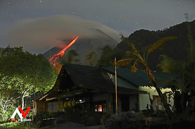
A lava flow on the flank of Mount Merapi. Volcano Discovery.

 
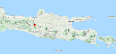
The approximate location of Mount Merapi. Google Maps.


Follow Sciency Thoughts on Facebook.

Follow Sciency Thoughts on Twitter. 


Wednesday, 27 January 2021

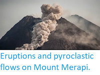
Eruptions and pyroclastic flows on Mount Merapi.

Mount Merapi, a 2970 m stratovolcano (cone-shaped volcano made up of layers of ash and lava) in Central Java, considered to be one of Indonesia's most active, erupted on Wednesday 27 January 2021, producing a column of ash 3000 m high away, as well as several new lava streams and pyroclastic flows (avalanches of hot ash and gas). There are no reports of any casualties associated with this eruption, and nor would they be expected, as a 3 km exclusion zone has been in place around the volcano since the current eruption cycle began in November 2020, although a number of elderly people have been evacuated from nearby communities by the Badan Nasional Penanggulangan Bencana.

 
A pyroclastic flow on Mount Merapi on 27 January 2021. Agung Supriyanto/AFP.

 
The approximate location of Mount Merapi. Google Maps.

See also...


Follow Sciency Thoughts on Facebook.

Follow Sciency Thoughts on Twitter. 


Monday, 22 June 2020

Two eruptions on Mount Merapi.

Mount Merapi, a volcano in Central Java considered to be one of Indonesia's most active, erupted twice on Sunday 21 June 2020, producing ash columns that rose to an altitude of about 6 km above sealevel. Each eruption lasted for about 7 minutes. The Badan Nasional Penanggulangan Bencana has not raised the alert level around the volcano, which has already erupted several times this year, although a 3 km exclusion zone around the site remains in place.

Eruption on Mount Merapi, Central Java, on Sunday 21 June 2020. Reuters.


The approximate location of Mount Merapi. Google Maps.
 
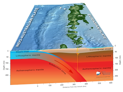
Subduction along the Sunda Trench. Earth Observatory of Singapore.

https://sciencythoughts.blogspot.com/2020/04/eruption-on-anak-krakatoa.htmlhttps://sciencythoughts.blogspot.com/2020/04/another-eruption-on-mount-merapi.html
https://sciencythoughts.blogspot.com/2020/03/mount-merapi-erupts-for-second-time.htmlhttps://sciencythoughts.blogspot.com/2020/03/largest-eruption-on-mount-merapi-so-far.html
https://sciencythoughts.blogspot.com/2020/02/mount-merapi-java-undergoes-first.htmlhttps://sciencythoughts.blogspot.com/2020/01/trying-to-understand-cause-of-22.html
Follow Sciency Thoughts on Facebook.

Thursday, 13 February 2020

Mount Merapi, Java, undergoes first significant eruption of 2020.

Mount Merapi, a volcano in central Java considered to be one of Indonesia's most active, erupted slightly after 5.15 am local time on Thursday 13 February 2020, acording to the Badan Nasional Penanggulangan Bencana, producing an ash column about 2 km in height. This is the first significant eruption on the volcano since November 2019, and led to ash falls within 1 km of the volcano in all directions, and as far as 10 km away to the south, the direction of the predominant winds at the time of the eruption.

An ash column over Mount Merapi, Java, on 13 February 2019. AFP.

Mount Merapi lies in a densely populated area of Java, on the borders of Central Java and Yogyakarta Provinces, only 28 km to the north of Yogyakarta city. It has been erupting more-or-less continuously since 1548, and has been responsible for numerous fatalities, most recently in 1994 when a pyroclastic flow (avalanche of hot gas and ash) killed 27 people, mostly in the town of Muntilan, to the west of the volcano. Since then Merapi has undergone tow major eruptive episodes, in 2006 and 2010, without any further loss of life, largely due to prompt evacuations by Indonesian authorities.

The approximate location of Mount Merapi. Google Maps.

The Indo-Australian Plate, which underlies the Indian Ocean to the south of Java, is being subducted beneath the Sunda Plate, a breakaway part of the Eurasian Plate which underlies Java and neighbouring Sumatra, along the Sunda Trench, passing under Java, where friction between the two plates can cause Earthquakes. As the Indo-Australian Plate sinks further into the Earth it is partially melted and some of the melted material rises through the overlying Sunda Plate as magma, fuelling the volcanoes of Java and Sumatra.

 Subduction along the Sunda Trench. Earth Observatory of Singapore.

See also...

https://sciencythoughts.blogspot.com/2020/01/trying-to-understand-cause-of-22.htmlhttps://sciencythoughts.blogspot.com/2020/01/flooding-and-landslides-kill-at-least.html
https://sciencythoughts.blogspot.com/2019/10/eruption-on-mount-merapi-java.htmlhttps://sciencythoughts.blogspot.com/2019/07/eruption-on-tangkuban-perahu-volcano.html
https://sciencythoughts.blogspot.com/2019/05/landslide-kills-five-at-illegal-mine-in.htmlhttps://sciencythoughts.blogspot.com/2019/02/landslide-kills-four-in-west-java.html
Follow Sciency Thoughts on Facebook.

Tuesday, 15 October 2019

Eruption on Mount Merapi, Java.

The Badan Nasional Penanggulangan Bencana has reported an eruption on Mount Merapi, a volcano in central Java considered to be one of Indonesia's most active, on Monday 14 October 2019. The eruption started slightly after 4.30 pm local time, and produced an ash column about 3 km high, which drifted to the southwest, where some communities have reported ashfalls.

 An eruption on Mount Merapi, Java, on 14 October 2019. Badan Nasional Penanggulangan Bencana.

Mount Merapi lies in a densely populated area of Java, on the borders of Central Java and Yogyakarta Provinces, only 28 km to the north of Yogyakarta city. It has been erupting more-or-less continuously since 1548, and has been responsible for numerous fatalities, most recently in 1994 when a pyroclastic flow (avalanche of hot gas and ash) killed 27 people, mostly in the town of Muntilan, to the west of the volcano. Since then Merapi has undergone tow major eruptive episodes, in 2006 and 2010, without any further loss of life, largely due to prompt evacuations by Indonesian authorities.

The Indo-Australian Plate, which underlies the Indian Ocean to the south of Java, is being subducted beneath the Sunda Plate, a breakaway part of the Eurasian Plate which underlies Java and neighbouring Sumatra, along the Sunda Trench, passing under Java, where friction between the two plates can cause Earthquakes. As the Indo-Australian Plate sinks further into the Earth it is partially melted and some of the melted material rises through the overlying Sunda Plate as magma, fuelling the volcanoes of Java and Sumatra.

 Subduction along the Sunda Trench. Earth Observatory of Singapore.

See also...

https://sciencythoughts.blogspot.com/2019/07/eruption-on-tangkuban-perahu-volcano.htmlhttps://sciencythoughts.blogspot.com/2019/05/landslide-kills-five-at-illegal-mine-in.html
https://sciencythoughts.blogspot.com/2019/02/landslide-kills-four-in-west-java.htmlhttps://sciencythoughts.blogspot.com/2019/01/fifteen-dead-and-twenty-missing-in-west.html
https://sciencythoughts.blogspot.com/2018/12/hundreds-dead-after-krakatau-eruption.htmlhttps://sciencythoughts.blogspot.com/2018/02/landslide-kills-at-least-seven-in.html
Follow Sciency Thoughts on Facebook.

Friday, 28 March 2014

Eruptive activity on Mount Merapi, Java.

Mount Merapi, a volcano in central Java considered to be one of Indonesia's most active, underwent a brief outburst of volcanic activity between 1.12 and 1.16 pm local time (6.12 and 6.16 am GMT) on Thursday 27 March 2014, during which it generated a number of small Earthquakes, as well as emitting volcanic gas and ejecting ash and gravel from its crater. The events have caused some concern locally, and been related to an Earthquake that occurred in the same region on Monday 24 March.
Mount Merapi on Thursday 27 March 2014. Balai Penyelidikan dan Pengembangan Teknologi Kebencanaan Geologi.


Mount Merapi lies in a densely populated area of Java, on the borders of Central Java and Yogyakarta Provinces, only 28 km to the north of Yogyakarta city. It has been erupting more-or-less continuously since 1548, and has been responsible for numerous fatalities, most recently in 1994 when a pyroclastic flow (avalanche of hot gas and ash) killed 27 people, mostly in the town of Muntilan, to the west of the volcano. Since then Merapi has undergone tow major eruptive episodes, in 2006 and 2010, without any further loss of life, largely due to prompt evacuations by Indonesian authorities.

The Indo-Australian Plate, which underlies the Indian Ocean to the south of Java, is being subducted beneath the Sunda Plate, a breakaway part of the Eurasian Plate which underlies Java and neighbouring Sumatra, along the Sunda Trench, passing under Java, where friction between the two plates can cause Earthquakes. As the Indo-Australian Plate sinks further into the Earth it is partially melted and some of the melted material rises through the overlying Sunda Plate as magma, fuelling the volcanoes of Java and Sumatra.

Follow Sciency Thoughts on Facebook.