Showing posts with label Central Java. Show all posts

Monday, 16 October 2023

A new population of the Critically Endangered rainforest tree Dipterocarpus littoralis discovered on Social Media.

Social media has become a surprisingly valuable tool for wildlife biologists, with a variety of new species described following posts by curious members of the public seeking to identify unknown organisms. 

In a letter to the journal Oryx published on 8 September 2023, Enggal Primananda and Iyan Robiansyah of the Research Center for Plant Conservation of the Indonesian National Research and Innovation Agency, report the discovery of a new population of the Critically Endangered rainforest tree Dipterocarpus littoralis based upon posts on the social media sites Facebook and Instagram.

Dipterocarpus littoralis had been thought to be restricted to the West Nusakambangan Nature Reserve on the western tip of Nusakambangan Island, which lies of the south coast of Central Java, where the known trees are found in a hilly forest at an altitude of about 100 m above sealevel.

The social media posts show a group of fruits and leaves which Primananda and Robiansyah believe clearly belong to Dipterocarpus littoralis, which were found in Tasikmalaya in West Java, about 70 km to the west of the West Nusakambangan Nature Reserve.

Image of an unknown Diptocarp fruit which Primananda and Robiansyah have identified as Dipterocarpus littoralis. Facebook.

If this identification is correct, then it indicates a significant range extension for Dipterocarpus littoralis, which may require a revision of its conservation status. Primananda and Robiansyah recommend that this new population be investigated as a matter of some urgency, and that specimens from the new location be added to the collection at Bogor Botanic Gardens. 

See also...


Follow Sciency Thoughts on Facebook.

Follow Sciency Thoughts on Twitter


Saturday, 12 March 2022

Evacuations following series of eruptions on Mount Merapi, Java.

Slightly over 250 people were evacuated from their homes temporarily following a series of eruptions on Mount Merapi, a 2970 m stratovolcano (cone-shaped volcano made up of layers of ash and lava) in Central Java, considered to be one of Indonesia's most active, that began slightly before midnight local time on Wednesday 9 March 2022. The volcano underwent a series of major eruptions between midnight and 2.00 am on Thursday 10 March, producing a series of lava rivers and pyroclastic flows. This prompted the Badan Nasional Penanggulangan Bencana to extend the exclusion zone around the volcano from 3 km to 7 km on a temporary basis, prompting the evacuations. The eruptions persisted till Friday 11 March, although they decreased in severity over time.

 
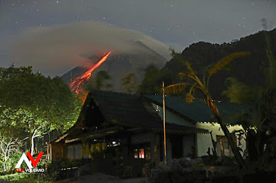
A lava flow on the flank of Mount Merapi. Volcano Discovery.

 
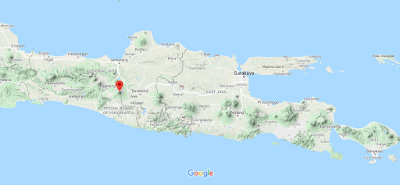
The approximate location of Mount Merapi. Google Maps.


Follow Sciency Thoughts on Facebook.

Follow Sciency Thoughts on Twitter


Wednesday, 27 January 2021

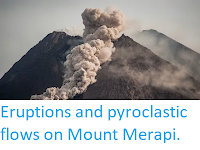
Eruptions and pyroclastic flows on Mount Merapi.

Mount Merapi, a 2970 m stratovolcano (cone-shaped volcano made up of layers of ash and lava) in Central Java, considered to be one of Indonesia's most active, erupted on Wednesday 27 January 2021, producing a column of ash 3000 m high away, as well as several new lava streams and pyroclastic flows (avalanches of hot ash and gas). There are no reports of any casualties associated with this eruption, and nor would they be expected, as a 3 km exclusion zone has been in place around the volcano since the current eruption cycle began in November 2020, although a number of elderly people have been evacuated from nearby communities by the Badan Nasional Penanggulangan Bencana.

 
A pyroclastic flow on Mount Merapi on 27 January 2021. Agung Supriyanto/AFP.

 
The approximate location of Mount Merapi. Google Maps.

See also...


Follow Sciency Thoughts on Facebook.

Follow Sciency Thoughts on Twitter


Monday, 22 June 2020

Two eruptions on Mount Merapi.

Mount Merapi, a volcano in Central Java considered to be one of Indonesia's most active, erupted twice on Sunday 21 June 2020, producing ash columns that rose to an altitude of about 6 km above sealevel. Each eruption lasted for about 7 minutes. The Badan Nasional Penanggulangan Bencana has not raised the alert level around the volcano, which has already erupted several times this year, although a 3 km exclusion zone around the site remains in place.

Eruption on Mount Merapi, Central Java, on Sunday 21 June 2020. Reuters.


The approximate location of Mount Merapi. Google Maps.
 
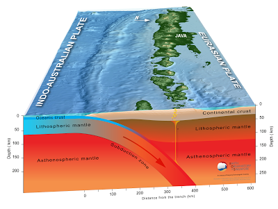
Subduction along the Sunda Trench. Earth Observatory of Singapore.

https://sciencythoughts.blogspot.com/2020/04/eruption-on-anak-krakatoa.htmlhttps://sciencythoughts.blogspot.com/2020/04/another-eruption-on-mount-merapi.html
https://sciencythoughts.blogspot.com/2020/03/mount-merapi-erupts-for-second-time.htmlhttps://sciencythoughts.blogspot.com/2020/03/largest-eruption-on-mount-merapi-so-far.html
https://sciencythoughts.blogspot.com/2020/02/mount-merapi-java-undergoes-first.htmlhttps://sciencythoughts.blogspot.com/2020/01/trying-to-understand-cause-of-22.html
Follow Sciency Thoughts on Facebook.

Friday, 10 April 2020

Another eruption on Mount Merapi.

Mount Merapi, a volcano in Central Java considered to be one of Indonesia's most active, erupted on Friday 10 April 2020, producing an ash column that rose to about 3000 m above the volcano's 2930 m summit and prompted the Badan Nasional Penanggulangan Bencana to issue a warning to aviation to avoid the area. This is the second major eruption on the volcano this month, the fifth this year, and the thirteenth since the current eruptive phase began in September 2019. Despite the size of this eruption it presents little threat to Human life, as there is already a 3 km radius exclusion zone surrounding the volcano, which the local population, being familiar with the dangers presented by the volcano, are unlikely to flout.

An ash cloud over Mount Merapi, Central Java, on 10 April 2020.


The approximate location of Mount Merapi. Google Maps.


Subduction along the Sunda Trench. Earth Observatory of Singapore.


https://sciencythoughts.blogspot.com/2020/03/mount-merapi-erupts-for-second-time.htmlhttps://sciencythoughts.blogspot.com/2020/03/largest-eruption-on-mount-merapi-so-far.html
https://sciencythoughts.blogspot.com/2020/02/mount-merapi-java-undergoes-first.htmlhttps://sciencythoughts.blogspot.com/2020/01/trying-to-understand-cause-of-22.html
https://sciencythoughts.blogspot.com/2020/01/flooding-and-landslides-kill-at-least.htmlhttps://sciencythoughts.blogspot.com/2019/10/eruption-on-mount-merapi-java.html
Follow Sciency Thoughts on Facebook.

Friday, 27 March 2020

Mount Merapi erupts for second time this month.

Mount Merapi, a volcano in central Java considered to be one of Indonesia's most active, erupted on the morning of Friday 27 March 2020, producing an ash column that rose to 5000 m above the island, according to the Badan Nasional Penanggulangan Bencana. This is the second major eruption from the volcano this month and the third this year, following eruptions on 13 February and 3 March. Several nearby communties have reported ashfalls following this eruption. 

Ash column over Mount Merapi on 27 March 2020.  Badan Nasional Penanggulangan Bencana.


The approximate location of Mount Merapi. Google Maps.


Subduction along the Sunda Trench. Earth Observatory of Singapore.


https://sciencythoughts.blogspot.com/2020/03/largest-eruption-on-mount-merapi-so-far.htmlhttps://sciencythoughts.blogspot.com/2020/02/mount-merapi-java-undergoes-first.html
https://sciencythoughts.blogspot.com/2020/01/trying-to-understand-cause-of-22.htmlhttps://sciencythoughts.blogspot.com/2020/01/flooding-and-landslides-kill-at-least.html
https://sciencythoughts.blogspot.com/2019/10/eruption-on-mount-merapi-java.htmlhttps://sciencythoughts.blogspot.com/2019/07/eruption-on-tangkuban-perahu-volcano.html
Follow Sciency Thoughts on Facebook.