The Australasian Strewn Field, a horizon of glassy clasts ('tektites') quenched from molten ejecta of a bolide impact about 790 000 years ago, extends across about ⅒th of the Earth’s surface, from Indochina to East Antarctica and from the Indian to western Pacific Oceans. The northwestward increase in both the abundance and the size of tektite specimens points to the impact site being in eastern central Indochina. This is within the region of Muong Nong-type tektites, the least streamlined, most volatile-rich, most siliceous, and largest of the ejected melt fragments. Their high silica content, relict grains, and other chemical characteristics indicate primarily quartz-rich coarse siltstone to fine sandstone target rocks, perhaps of Jurassic age. Concentrations of microtektites and iridium in contemporaneous marine sediments more than a 1000 km away from the impact region yield very poorly constrained estimates of crater diameter, ranging from 15 to 300 km. Given these large crater sizes, it is remarkable that the many searches of the past half-century have yielded neither a definitive impact site nor a proximal ejecta blanket. This failure implies either that a crater never formed, or that either burial or erosion has obscured it.
In a
paper published in the
Proceedings of the National Academy of Sciences of the United States of America on January 2020,
Kerry Sieh and
Jason Herrin of the
Earth Observatory of Singapore at
Nanyang Technological University,
Brian Jicha of the
Department of Geoscience at the
University of Wisconsin–Madison,
Dayana Schonwalder Angel,
James Moore, and Paramesh Banerjee, also of the Earth Observatory of Singapore at Nanyang Technological University, Weerachat Wiwegwin of the
Department of Mineral Resources at the
Ministry of Natural Resources and Environment of Thailand, Vanpheng Sihavong of the Department of Geology and Mines at the
Ministry of Energy and Mines of the Lao People’s Democratic Republic,
Brad Singer, also of the Department of Geoscience at the University of Wisconsin–Madison, Tawachai Chualaowanich, also of the Department of Mineral Resources at the Ministry of Natural Resources and Environment of Thailand, and Punya Charusiri of the
Department of Geology at
Chulalongkorn University, present evidence for the Australasian Strewn Field Tektite Impact Crater being located beneath the Bolaven Volcanic Field of southern Laos.

The Bolaven Plateau Volcanic Field likely buries the impact crater that produced the tektites of the Australasian Strewn Field. It is the only adequately large and thick postimpact deposit on the Khorat Plateau, the largest region of plausible target rocks. It is also the only thick, postimpact deposit within the inner Muong Nong strewn field, the region containing exclusively nonaerodynamically shaped Muong-Nong–type tektites (circumscribed by the blue ellipse). (Inset) Finds of Australasian Tektites and Microtektites (white dots) define an asymmetric strewn field (blue). Sieh et al. (2020).
The most promising place to look for either an eroded or a buried crater is within the largest, contiguous expanse of fine grained, siliclastic (sedimentary rock largely composed of silica compounds) Mesozoic sedimentary rocks in the region, the Khorat Plateau. However, obscuration by erosion within this 155 000 km² region of predominantly gentle topography is not plausible. The crater rim is likely to have risen more than 100 m above the target surface, but post impact erosion of the region by the Mekong River and its tributaries has been far less than this. This is clear from the facts that tektites occur in situ primarily on gentle surfaces no more than a few tens of meters above modern nearby streams and that pre-impact basalt flows cover surfaces that are only about 50 m above the stream bed of the modern Mekong River.

Evidence that erosion does not obscure the impact crater. Height of pre-impact surfaces and lava flows above nearby modern stream channels at our sites in eastern Thailand and along the Mekong River and a major tributary. These demonstrate that post-impact incision by the Mekong River system into the rocks and sediments of the Khorat Plateau is too slight to have obliterated the primary features of a large impact crater. Squares indicate post-impact lava flows; circles indicate tektite site. Sieh et al. (2020).
Moreover, field examinations of candidates for an eroded crater, several large, circular, low-relief features in central Laos and northern Cambodia, have shown that these are, instead, eroded synclines in Mesozoic rock (i.e. folds in the rock that projected upwards, but which have eroded away, leaving exposures that cut through the same layers on either side, sometimes resembling a crater). Likewise, examination of a proposed crater in northeast Cambodia revealed that it is, in fact, the top of a granitoid pluton surrounded by a resistant contact-metamorphic quartzite aureole derived from surrounding Mesozoic sandstone. Another candidate crater in southern China appears to have a similar origin.
Burial of the impact crater might also seem unlikely, because adequately wide and thick post impact sedimentation is nearly absent on the Khorat Plateau. The only notable exception is an extensive basaltic volcanic field centred on the Bolaven Plateau in Southern Laos. Siah et al. present evidence below that this thick pile of volcanic rocks does indeed bury the site of the impact.
The 6000 km² Bolaven Plateau rises about 1 km above the Khorat Plateau in Southern Laos, east of the Mekong River. Fine-grained, nearly flat-lying Mesozoic quartz sandstones and mudstones underlie this elevated surface and crop out almost continuously around its cliffy perimeter. Judging from the nearly vertical pitches at the top of this perimeter cliff and from outcrops on the plateau, the uppermost 200–250 m of the Mesozoic bedrock comprise massive to cross-bedded fluvial sandstones. Gentler slopes below indicate that friable mudstones dominate the underlying 250 m. If the Australasian bolide struck the Bolaven Plateau, this 500 m thick sandstone–mudstone sequence would have comprised much of the impacted target rock.

The Bolaven volcanic field covers much of the Bolaven Plateau and spills over its kilometre high flanks to the floodplain of the Mekong River. The perimeter cliffs of the plateau expose nearly flat-lying Mesozoic sandstones and mudstones like those inferred from tektite composition to be the dominant target rocks of the Australasian impactor. Argon⁴⁰-argon³⁹ ages on lavas appear as dots coloured according to age. Siah et al. (2020).
However, a basaltic volcanic field that covers an area of about 5000 km² caps these rocks and spills down the flanks of the plateau. Structure contours drawn on the Mesozoic bedrock/basalt contact by interpolating under the lavas between bedrock outcrops allowed Siah et al. to create an isopach map of the volcanic field. From this they calculate a volcanic volume of about 910 km³. In the vicinity of the summit region of the volcanic field, the basalt is up to 300 m thick. This extent and thickness are great enough to hide a crater up to 15 km in diameter and with a rim that rises up to a couple hundred meters above the bedrock surface.

Detailed map of the Bolaven Plateau region. Screenshot of detailed geological map of the Bolaven Plateau and surroundings created by analysis of Shuttle Radar Topography Mission 30 m topography and follow-up fieldwork. In preparation for collection of samples for geochronology and to evaluate opportunities to test the Bolaven impact hypothesis in the field. Siah et al. (2020).
Siah et al. offer four tests of the hypothesis that the Australasian impact crater lies buried beneath the basaltic lavas of the Bolaven Plateau. First, they examined published geochemical analyses of the tektites to test whether or not they could include a basaltic component. If the bolide that created the Australasian tektites impacted a location that had a cover of mafic lavas, then the Bolaven volcanic field would be a prime candidate for the impact site. Second, they used the argon⁴⁰-argon³⁹ dating method to date many of the flows comprising the volcanic field, to see if they both antedate and postdate the impact. The presence of basalts older than the impact date would imply a contribution to the ejected materials. Basalts younger than the impact would need to wholly mantle the proposed impact site. Third, they conducted a field program of gravity measurements to see if there is a gravity anomaly that would reflect a large buried crater. And fourth, they search for coarse proximal ejecta with shocked quartz, as evidence for an impact site under the basalts of the plateau.

Thickness of basalts of the Bolaven volcanic field. Thickness of basalt flows, constructed by subtracting elevations of the contact between basalt and underlying Mesozoic bedrock from elevations of the top of the basalts. Note the 25 km wide basaltic cap atop the plateau and the thick western-canyon fill and northern fans. Black dots are locations of our gravity measurements, and the black ellipse indicates the proposed crater location, from analysis of the gravity field. Shading is for lighting from both 0° and 90°. The sharp discontinuity just inside the southern, western and northern perimeters of the lavas is an artifact of the way the base of the basalt has been contoured, it was assumed that elevations were uniform on each side and that there is a 50 m step up along that line. Siah et al. (2020).
Previous investigations have observed magnesium concentrations in Australasian Tektites higher than are typical in siliciclastic sediments and have proposed a Mafic (iron-rich volcanic) component within the target rocks. Sporadic enrichment in nickel cobalt, and chromium, without a concomitant enrichment of highly siderophile elements ('iron-loving' elements; i.e. elements which will dissolve in iron, such as ruthenium, rhodium, palladium, rhenium, osmium, iridium, platinum, and gold), also points to a mafic terrestrial source.
To examine further the possible presence of mafic rocks at the impact site at the time of impact, Siah et al/ performed an analysis of published major-element compositions of 241 Australasian Tektites from various locations. They found that over 90% of the observed chemical variation can be readily explained by mixing of Mesozoic sequences of the Khorat Plateau with Bolaven basalts. with more distal tektites, such as Australites, tending toward higher proportions of basalt.
Histogram of relative contributions of Bolaven basalt and Bolaven Mesozoic rocks to best-fit solutions for 241 Australasian Tektites. Major-element compositions of tektites are consistent with a modal average of 30-40 weight percent addition of a basaltic component to a fluvial sandstone precursor. A small group of Australites are consistent with higher basalt contributions in the range 55-70% by weight. Siah et al. (2020).
Variations in the strontium isotopic composition of Australasian Tektites also show mixing of a low-strontium, high strontium⁸⁷/strontium⁸⁶ end member with a high-strontium, less-radiogenic component (strontium isotopes vary a great deal with local geology and hydrology, and are useful for determining the origin of displaced rocks), again consistent with an admixture of Mesozoic bedrock with Bolaven volcanics and their weathering derivatives. Similarly, the more basalt-like strontium component is expressed to a greater extent in more distal tektites, the Australites in particular.
Characteristically high levels of the beryllium isotope berylium¹⁰ in Australasian tektites is also noteworthy because it places considerable constraint on their genesis. Beryllium¹⁰ is formed when cosmic rays hit oxygen or nitrogen molecules in the atmosphere, causing them to lose protons and neutrons, a process called spallation. Elevated ¹⁰berylium implies that the impacted rocks contained a significant fraction of materials exposed to near-surface conditions within the few million years prior to the impact.

Schematic depiction of tektite trajectories out of the impact crater offer an explanation for distal tektites having a higher component of basalt than proximal tektites. Cross-section of impact crater depicts basalt and basalt-derived saprolites overlying a laterite surface and a Mesozoic fluvial sequences of sandstone and mudstone. Trajectory (1) would be the path of the most-distal ejecta, Australites and Antarctic Microtektites. Their chemistry is closest to that of the basalt-rich layers. The ratio of basalt to bedrock along Trajectory (1) is high relative to the ratio along Trajectories (2) and (3). Trajectory (2) represents the paths of intermediate-range ejecta, such as splash form tektites from Indonesia, the Philippines, southern China, and greater Indochina. Trajectory (3) represents the paths of the most-proximal ejecta, the Muong Nong Tektites, found predominantly in southern Laos and eastern Thailand. Siah et al. (2020).
Siah et al. observe that basalts on the plateau weather largely to clay-rich saprolite (granite-derived soil) within a couple of hundred thousand years. These clayey layers are well-suited for absorption and retention of meteoric berylium¹⁰, which, unlike berylium¹⁰ produced in minerals and commonly used in determination of surface-exposure ages, forms by spallation of nitrogen and oxygen in the atmosphere and precipitates onto and into surface layers. Stacking of successive basalt flows would create a sequence of berylium¹⁰-enriched saprolites many times thicker than what could be achieved on the erosional surface cut into the Mesozoic sandstones of the Bolaven Plateau. Thus, we propose that a stack of weathered pre-impact basalt flows accounts for the anomalously high berylium¹⁰ concentrations observed in Australasian Tektites. As with the geochemical trends described above, the increasing enrichment of berylium¹⁰ with distance from Indochina is consistent with ejection trajectories that yield a greater basaltic component farther from the impact.
If lavas bury the impact crater, they must be younger than the impact. Conversely, if there is a component of basalt in the tektites, thee must also be flows there that antedate it. Radioisotopic dating of flows on the plateau offers a test whether both of these two requirements are met.
Argon⁴⁰-argon³⁹ dating relies on determining the ratio of non-radioactive argon⁴⁰ to radioactive argon³⁹ within minerals from igneous or
metamorphic rock (in this case volcanic ash) to determine how long ago
the mineral cooled sufficiently to crystallise. The ratio of argon⁴⁰ to argon³⁹ is constant in the atmosphere, where argon³⁹ is formed by the spallation of argon⁴⁰ at a constant rate, and this ratio will be preserved
in a mineral at the time of crystallisation. No further argon³⁹ will
enter the mineral from this point, but argon⁴⁰ is produced by the decay
of radioactive potassium⁴⁰, and increases in the mineral at a steady
rate, providing a clock which can be used to date the mineral.
Three published argon⁴⁰-argon³⁹ dates for the Bolaven lavas, ranging from 16 million to 50 000 years old, span the impact date. However, these dates are too few and too far from the proposed impact site to test either hypothesis.
The youthful appearance of the volcanic landforms in the vicinity of the summit and down most of the northern and southern flanks of the plateau suggests that most exposed flows are Late Quaternary in age. Most of the exposed flows and cinder cones of the Bolaven field do not exhibit appreciable erosion, despite the region’s heavy tropical rainfall (about 150 cm per year). Canyons erode into only restricted, steep portions of the western and southern flanks of the field. Moreover, large tracts of the northern and southern field sport very thin tropical soils and exhibit scant saprolitization (granite weathering).

Photographs of several exposures of the young lava flows. (a) Exposure of 779 000 year old basalt flow in a quarry near the western edge of the Bolaven plateau. Most of the exposure is thick, clayey saprolite derived from the basalt flow, of which only un-weathered core stones remain. This flow is incised several hundred meters by streams that plunge over the western flank of the plateau. (b) Un-weathered core stones from this 3 m high outcrop near the northwestern edge of the Bolaven plateau yielded a date of 215 000 years before the present. Clayey saprolite comprises most of the outcrop. (c) Basalt boulders at the flow front of a very young flow on the northern edge of the Bolaven volcanic field. Presence of boulders at the surface indicates scant soil development and perhaps a Holocene age. (d) Collapsed lava tube near the terminus of the most sparsely vegetated flow, at the southern edge of the Bolaven volcanic field. This flow yielded the youngest argon⁴⁰-argon³⁹ plateau ages, about 27 000 years before the present. Siah et al. (2020).
Siah et al. dated 37 exposed flows via argon⁴⁰-argon³⁹ incremental-heating experiments. The dating strategy was two-pronged: They targeted a suite of lavas that spans the spectrum of geomorphologically young to old flows––that is, from those that exhibit little to no erosion or soil formation to those that are highly dissected and saprolitized and lack preserved upper-flow surfaces. They also focused on flows near the summit region, at and adjacent to the proposed epicentre of the impact. All analyses are of ground mass, so the argon⁴⁰-argon³⁹ dates reflect the time since cooling of the flows. None of the lavas contain significant excess argon and all of the samples produced dates consistent with the argon present having an atmospheric origin.
The dates show that eruptions occurred over a sustained period of time, from about 16 million years ago to about 27 000 years ago. Fourteen samples antedate the impact, 21 postdate it, and two are approximately contemporaneous with the impact.
All twelve dates from lavas in the summit region and directly above the proposed crater are distinctly younger than the date of the impact. Moreover, all but two of the dated flows within 8 km of the hypothetical crater perimeter are younger than or close to the date of the impact, ranging from about 51 000 to about 779 000 years old. The two exceptions are these are: (i) An approximately 1.26 million year date about 7 km west of the inferred crater rim and buried about 55 m below a nearby surface flow with a date indistinguishable from the 790 000 years ago date of the impact, and (ii) an approximately 12 million year date from a 200-m-wide mound of highly weathered basalt about 6 km southeast of the inferred crater rim. This volcanic lump may be the remnant of a small scoria (basaltic lava) cone serendipitously left uncovered by the ejecta blanket and post impact lavas.
The fact that all of the dates from lava flows above the proposed crater and most dates nearby are younger than the impact lends support to the hypothesis that Bolaven lavas fill the impact crater and completely obscure it. Conversely, pre-impact ages for many flows on the periphery of the volcanic field, imply that there are basaltic lavas, now buried beneath the young summit lavas that were impacted by the bolide, as reflected especially in the chemistry of the more distal tektites.
Geophysists can use the local gravity fields to determine the nature of buried rocks and other structures. This is because gravity related directly to mass, so denser matter (high mass to volume) excerpts a higher gravitational pull than less dense (low mass to volume) matter. Local gravitational fields can be described as being positive (indicating dense buried matter) or negative (indicating low density buried matter) relative to the surrounding area.
If there were a large crater buried beneath the summit region of the Bolaven Plateau, it would likely be apparent in the local gravity field. For example, if dense basalt fills the portion of the crater that is below the plane of the eroded bedrock surface, then it would manifest in a positive gravity anomaly consistent with its horizontal dimensions. Alternatively, if loose impact debris fills this lower part of the crater, the gravity field would exhibit a negative anomaly. If this part of the crater fill is a combination of basalt and impact debris, then the sign of the anomaly would depend on which of the deposits were prevalent. The presence of an ejecta blanket, perhaps 100 or 200 meters thick at the crater rim and lying atop the pre-impact surface, should manifest as a negative anomaly.
In search of such an anomaly, Siah et al. measured gravity at 404 locations, focused upon the summit region of the volcanic field but extending well beyond the Bolaven Plateau’s perimeter, to constrain the regional gravity signal. The gravity map obtained exhibits a regional southwest-to-northeast negative gradient ornamented with several smaller anomalies on the plateau.

(a) Bouguer gravity map of the Bolaven Plateau and surrounding region that assumes a uniform density typical for sandstone (2400 kg m³) and a terrain correction up to 170 km. Smaller anomalies on the plateau interrupt the pronounced regional southwest-to-northeast gradient. This map reflects the subtraction of the -53 mGal average value of all points, so that the map contours centre on a value of zero. Contour interval is 1 mGal. Black dots indicate all but the most distal of the 404 measurement locations. Contour interval is 1 mGal, and thicker contours appear at intervals of 4 mGal. Regions further than ~5km away from any measurements are grey. Proposed crater location outlined by black ellipse. (b) Regional map, where bounds of Figure (a) are marked with a red box. Siah et al. (2020).
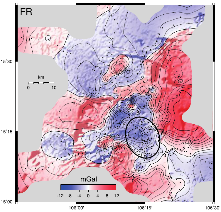
Of particular interest is a 20 km wide, roughly 8 mGal (milligal) anomaly in the summit region of the volcanic field. Siah et al. processed the Bouguer gravity field to account for contributions from basalt flows and low-density components in the western-canyon fill and northern fan to yield a gravity field, in which a large negative anomaly still remains within the region of the suspected impact crater.

Fans removed map generated by the removal of regional gradient using a best-fit bi-linear ramp and from removal of the western- canyon and northern-flank anomalies by assuming substantial amounts of low- density basalt-derived alluvium and saprolite in those locales. Siah et al. assume a material density of 1800 kg m-3 for these materials, based upon an initial density 2400 kg m³ and 25% unfilled pore space. The best fit for north-flank fan thicknesses result from simultaneous minimization of the L2 norm of (BR + correction terms + ramp) using a simulated annealing method and 1000 starting search points. Proposed crater location outlined by black ellipse. Siah et al. (2020).
Most of that remaining negative 6 mGal anomaly disappeared when iah et al. replaced a portion of the basalt with a 100 m- hick, elliptical lens of low density breccia within an elongated crater that is about 13 km wide and 17 km long. An ellipticity of around 30% would correspond to an impact angle of about 10°. Of course, the use of this simple lens of low-density material would be a simplification of the actual geometry of materials related to the proposed crater.
Cross-section through the summit region of the Bolaven Plateau volcanic field that assumes a buried crater with a geometry nearly identical to that published for the similar-sized Ries Crater in southern Germany. No vertical exaggeration; horizontal lines are at 200 m intervals. Siah et al. (2020).
The gravity anomaly cannot reflect the presence of a volcanic caldera, buried beneath the lavas, because calderas are features associated with large crustal magma reservoirs beneath composite volcanoes. The Bolaven field and similar intraplate volcanic fields comprise scattered, low-eruption-volume scoria cones and flows that reflect the rise of individual batches of magma. The absence of long-lived, localised composite volcanoes on the Bolaven Plateau implies the absence of an underlying crustal magma reservoir. Thus, the presence of large crustal magma volumes characteristic of calderas is unlikely. Further evidence against the existence of a buried caldera is the lack of Quaternary Age ignimbrite (volcanic rock consisting essentially of pumice fragments) or high-porosity volcanoclastic deposits in the region of the Bolaven Plateau. These are commonly associated with composite volcanoes and calderas.
Another unlikely explanation for the gravity anomaly is a maar (broad, low-relief volcanic crater caused by a phreatomagmatic eruption), a common feature of volcanic fields, characterised by craters with floors lying 5 to 400 m below the pre-eruptive surface, surrounded by a ring of ejecta and sourced from a low-density diatreme (volcanic pipe formed by a gaseous explosion). Maar craters are, however, typically only about a kilometre in diameter, considerably smaller than the dimensions of the anomaly Siah et al. observe.
A fourth positive, and perhaps definitive test of the Bolaven crater hypothesis would be discovery of proximal ejecta. Lavas mantle most of the western half of the Bolaven Plateau, however, so one might consider the search for an ejecta blanket to be a fool’s errand. Of great significance, then, is one small pie-shaped piece of oddly rilled terrain 10–20 km southeast of the summit of the volcanic field. This patch is the largest area near the summit that has escaped volcanic burial. Streams there flow southeastward in 40 to 50 m deep valleys, away from the summit and with much closer spacing than drainages either atop or cutting into the lavas. In the two places where Siah et al could gain access through the thick jungle vegetation, the stream beds are flowing on in situ, flat-lying sandstone bedrock. This suggests that the rills have cut through a loose, 40 to 50 m-thick deposit to its basal contact with bedrock.
The looser material that forms the closely spaced rills is exposed in two road cuts. The better-exposed of these displays well a fining upward breccia of angular sandstone and mudstone clasts (clasts are individual fragments of rock, in this instance mudstone). The lowest bed in the exposure is a monolithologic, cobbly, and bouldery fine-sandstone breccia, in a matrix of angular sand grains and pebbles. The overlying bed is a monolithologic, cobbly, boulder mudstone breccia. These two breccia beds are remarkable for the fact that large domains within the outcrop comprise cobbles and boulders that fit together like jigsaw-puzzle pieces. Overlying the mudstone breccia is a thin sandstone breccia. Overlying and in sharp contact with this is a massive coarse silt to very fine sand, which we ascribe to deposition as a loess-like bed from a convecting cloud produced by the impact, similar to the genesis proposed for deposits in eastern Thailand.

Sandstone boulders within an impact-breccia deposit ∼20 km southeast of the centre of the proposed crater contains abundant planar fractures in quartz crystals. Boulders shattered in situ at the end of ballistic trajectories from the proposed crater. Siah et al. (2020).
The sedimentological and stratigraphic nature of the lower three beds in this outcrop is consistent with the rapid accumulation of clasts at the end of ballistic trajectories from the impact crater. The angular nature of both framework and matrix indicates that they did not experience rounding during transport, as would be expected if they arrived as bed load in a very powerful stream. The jigsaw-puzzle-like fitting of neighbouring clasts in the coarse, lower two beds is wholly unlike outcrops of intensely weathered siliclastic bedrock elsewhere on the plateau. These jigsaw patterns imply that the boulders shattered at the site and support the argument that they could not have been transported to the site in a debris flow or weathered in situ. Moreover, the size of the sandstone boulders implies very high energies of emplacement, far greater than are plausible in the small neighbouring stream, which has no large tributaries and descends only about 100 m from its headwaters 4 km upstream.

Roadcut exposure of impact ejecta exposes a fining-upward, irregularly bedded sandstone and mudstone breccia. The color-coded boulders and cobbles in the lower part of the outcrop are sandstone (pink) and mudstone (green). The sandstone and mudstone clasts broke apart in situ. This fact supports our argument that they landed as ballistic clasts and were not deposited as part of a debris-flow, landslide or avalanche. The unexposed base of the breccia lies between the base of the roadcut and in situ Mesozoic fluvial sandstone that crops out in the streambed about 10 m below. This unexposed section may contain basaltic debris. Siah et al. (2020).
Siah et al. argue that this outcrop exposes part of the ejecta blanket that surrounds the impact site. The fact that the thick mudstone breccia overlies the sandstone breccia supports this claim, because inversion of the ordering of the Mesozoic stratigraphy (layers) of the plateau, roughly 200 m of sandstone overlying about 250 m of mudstone, is what one would expect in the ejecta blanket. They estimate the impact velocity for these boulders to be about 450 metres per second, assuming that they exited the crater at an angle between 45° and 60°. If these beds represent inverted stratigraphy of the target rocks, one would expect a breccia bed comprising basalt debris directly beneath the sandstone breccia layer and atop bedrock. Unfortunately, the several meters of section between the sandstone bed and bedrock is not exposed, but there are rare, loose basalt clasts atop bedrock in a nearby stream bed that might have come from that unexposed, basal part of the breccia.
Discovery of shocked quartz within the sandstone boulders would provide an independent test of whether this outcrop represents a part of the eject blanket, Not finding evidence of shocked quartz would support the argument that this is not an impact deposit, even though its sedimentological nature and setting preclude any other origin that we can imagine. Petrographic examination reveals that the quartz grains in the sandstone boulders do indeed have planar fractures like those caused by high-velocity impacts, but quartz grains in the underlying bedrock do not.
First Siah et al. examined differences in the petrographic textures of the in situ bedrock and the overlying ejecta deposit. The bedrock comprises dominantly angular to sub-angular medium-size grains of quartz sand with little to no matrix. In contrast the boulder from the ejecta deposit consists principally of very fine to fine-grained angular quartz sand floating in a nondescript, clayey matrix. We are uncertain whether this texture is an original depositional texture or the result of post depositional comminution (fragmentatiion) and weathering, but the latter is a possibility.

(a) Texture of sandstone sample from the bedrock. The rock comprises a clast supported, well sorted coarse-grained quartz sandstone. Yellow arrow shows typical planar fractures of the bedrock. (b) Example of irregular planar fractures crossing grain boundaries in the bedrock. (c) Textures in the sandstone boulders in the ejecta deposits. The rock is matrix supported, with smaller sub-angular quartz grains that are spatially separated. (d) Example of planar fractures associated with shock metamorphism.(e) Example of planar fractures similar to the ones observed in the bedrock, non shock related. Siah et al. (2020).
Fractures appear in the quartz grains of both the bedrock and the boulders. However, fractures in the bedrock grains do not have the characteristics of shock-related fractures: They are curved and display variations in thickness. They are not evenly distributed within a grain and in some cases continue across grain boundaries. Similar fractures exist in some grains of the sandstone boulders.
However, Siah et al. also observe grains in the boulders that display very distinct, parallel, planar fractures about 2 μm wide and 2–18 μm apart. These do not cross grain boundaries.
In some of these crystals Siah et al. measured the apparent polar angles between the index plane of the planar fractures and the c axes (in describing the geometry of crystals three axes are used, a, b, and c) of the host quartz grains, to see if they are within the range of crystallographic orientations proposed by others to be typical of shock-related features. most of the calculated polar angles cluster around 52° and 66°, which could correspond to Miller Index planes, notably {10 11}, that are typical in shocked quartz grains. The predominance of fractures with these crystallographic orientations have sometimes been used to distinguish high-pressure (10–35 GPa) planar deformation features. Compelling evidence that the fractures in the Bolaven Plateau quartz grains are planar deformation features would require measurement of 100 or so samples. Siah et al. have elected not to do such a comprehensive test, since they have so many other lines of evidence that the deposit is part of a proximal ejecta blanket, i.e., the poorly sorted nature of the deposit itself, the angularity of both its large and small clasts, and the proximity of the deposit to the proposed crater rim. Siah et al. hypothesise that these quartz grains do indeed reflect the weak (less than 10–20 GPa) shocking that one would expect in rocks that originated near the perimeter of the excavating crater.

Microphotograph in plane-polarized light of parallel planar fractures (upper left to lower right) in 1 quartz crystal. The fractures are well-defined and do not cross grain boundaries. Siah et al. (2020).
One other site that might contain proximal ejecta is on the northeast flank of the suspected crater. Strewn on a small, faulted inselberg (isolated hill or mountain) of Mesozoic bedrock surrounded by basalt are large blocks of cross-bedded Mesozoic fluvial sandstone. None of these large boulder slabs are overturned, but the extreme discordance of dips and strikes from boulder to boulder is consistent with their having been thrown out of the crater onto the crater rim. Alternatively, these loose blocks might have been dislodged by the passage of impact shock waves or normal faulting underfoot during collapse of the impact crater rim. Similar outcrops of very large boulders occur on the crest of a ridge 1 or 2 km southeast of the proposed crater rim.
Four lines of evidence imply strongly that the impact that produced the vast Australasian Strewn Field lies beneath young lavas of the Bolaven Volcanic Field in Southern Laos. First, the Mesozoic siliclastic rocks and young overlying pre-impact basalts of the plateau are consistent with tektite geochemistry and relict mineralogy. Second, exposed lava flows above and near the hypothesised crater are younger than the 790 000 years before present date of the impact. Third, a negative gravity anomaly at the summit region of the volcanic field is of a dimension and magnitude consistent with the presence of low-density clastic deposits associated with an impact crater. Finally, an outcrop 10–20 km from the proposed impact site consists of brecciated sandstone and mudstone boulders that appear to have shattered in situ during ballistic emplacement. Planar deformation features in quartz grains within 1 of the boulders imply shock metamorphism that supports this interpretation.
See also...