Showing posts with label North Sea Grabens. Show all posts

Wednesday, 8 July 2020

Magnitude 4.9 Earthquake in western Poland.

The United States Geological Survey recorded a Magnitude 4.9 Earthquake at a depth of 10.0 km, approximately 2 km to the southeast of the village of Rudna in Lubin County in Lower Silesia Province, Poland, slightly before 7.20 am local time (slightly before 6.20 am GMT) on Wednesday 8 July 2020. There are no reports of any damage or casualties associated with this event, although it was felt locally.

 The approximate location of the 8 July 2020 Lower Silesia Earthquake. USGS

Poland is in northern Europe, an area not noted for its Earthquakes, but not completely immune either. Like other areas where Earthquakes are uncommon, it is seldom possible to give a precise cause for Polish Earthquakes, with both probably being the result of more than one source of tectonic pressure. The strongest source of tectonic stress in southern Poland is the impact of Africa with Europe, far to the south. This is causing uplift and folding in the Alpine region of Central Europe, and exert pressure on the rocks further to the north. There are also areas of minor tectonic spreading beneath the Rhine Valley and North Sea, both of which cause stress over a wide area. Finally there is glacial rebound; until about 10 000 years ago much of northern and upland Europe was covered by a thick layer of glacial ice, pushing the rocks of the lithosphere down into the underlying mantle. This ice is now gone, and the rocks are slowly springing back into place, causing occasional Earthquakes in the process.

Witness accounts of Earthquakes can help geologists to understand these events, and the structures that cause them. The international non-profit organisation Earthquake Report is interested in hearing from people who may have felt this event; if you felt this quake then you can report it to Earthquake Report here.

See also...

https://sciencythoughts.blogspot.com/2019/01/seven-injured-and-one-missing-following.htmlhttps://sciencythoughts.blogspot.com/2018/07/magnitude-50-earthquake-in-lower.html
https://sciencythoughts.blogspot.com/2017/11/seven-dead-as-north-sea-storm-herwart.htmlhttps://sciencythoughts.blogspot.com/2017/08/poland-storms-kill-five.html
https://sciencythoughts.blogspot.com/2016/09/cave-in-at-polish-copper-mine-kills-two.htmlhttps://sciencythoughts.blogspot.com/2013/12/at-least-twelve-dead-as-cyclone-bodil.html


 Follow Sciency Thoughts on Facebook.

Friday, 24 April 2020

Magnitude 3.3 Earthquake beneath the southern North Sea.

The British Geological Survey recorded a Magnitude 3.3 Earthquake at a depth of 10 km about 40 km of the coat of Norfolk, England, slightly after 6.30 am British Summertime (slightly after 5.30 am GMT) on Thursday 23 April 2020. There are no reports of any damage or injuries associated with this event, though it may have been felt on parts of the English easr coast.
 
The approximate location of the 23 April 2020 North Sea Earthquake. Google Maps.
 
Earthquakes become more common as you travel north and west in Great Britain, with the west coast of Scotland being the most quake-prone part of the island and the northwest of Wales being more prone  to quakes than the rest of Wales or most of England.
 
The precise cause of Earthquakes in and around the UK can be hard to determine; the country is not close to any obvious single cause of such activity such as a plate margin, but is subject to tectonic pressures from several different sources, with most quakes probably being the result of the interplay between these forces.
 
Britain is being pushed to the east by the expansion of the Atlantic Ocean and to the north by the impact of Africa into Europe from the south. It is also affected by lesser areas of tectonic spreading beneath the eastern North Sea, Rhine Valley and Bay of Biscay, notably the Lower Rhine Graben, an area of tectonic expansion beneath the Rhine Valley, and the North Sea Central Graben, the Terschelling Graben and The Horn Graben, the similar areas of expansion beneath the North Sea. These areas do not generate new ocean floor or expand on the same scale as the Mid Atlantic Ridge or similar structures, but they do exert pressure on the rocks around the North Sea Basin, and can lead to Earthquakes in any of the countries surrounding the Basin.
 
  Map showing the location of the North Sea Central and Terschelling Grabens. Numbered locations are oil rigs. Abbink et al. (2001).

Finally the country is subject to glacial rebound; until about 10 000 years ago much of the north of the country was covered by a thick layer of glacial ice (this is believed to have been thickest on the west coast of Scotland), pushing the rocks of the British lithosphere down into the underlying mantle. This ice is now gone, and the rocks are springing (slowly) back into their original position, causing the occasional Earthquake in the process.

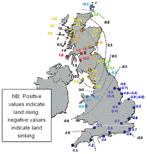
(Top) Simplified diagram showing principle of glacial rebound. Wikipedia. (Bottom) Map showing the rate of glacial rebound in various parts of the UK. Note that some parts of England and Wales show negative values, these areas are being pushed down slightly by uplift in Scotland, as the entire landmass is quite rigid and acts a bit like a see-saw. Climate North East.

Witness accounts of Earthquakes can help geologists to understand these events, and the structures that cause them. If you felt this quake, or were in the area but did not (which is also useful information) then you can report it to the British Geological Survey here.

See also...

https://sciencythoughts.blogspot.com/2020/01/caravans-left-balancing-in-cliff-edge.htmlhttps://sciencythoughts.blogspot.com/2019/12/learthback-turtle-found-on-beach-in.html
https://sciencythoughts.blogspot.com/2019/10/modiolus-cimbricus-new-species-of.htmlhttps://sciencythoughts.blogspot.com/2019/09/humpback-whale-washes-up-on.html
https://sciencythoughts.blogspot.com/2019/08/magnitude-30-earthquake-off-coast-of.htmlhttps://sciencythoughts.blogspot.com/2019/03/magnitude-17-earthquake-off-coast-of.html
Follow Sciency Thoughts on Facebook.

Wednesday, 30 January 2019

Seven injured and one missing following Magnitude 4.1 Earthquake in Lower Silesia, Poland.

The United States Geological Survey recorded a Magnitude 4.1 Earthquake at a depth of 10.0 km, approximately 3 km to the southwest of the town of Grębocice in Lower Silesia Province, Poland, slightly before 1.55 pm local time (slightly before 12.55 pm GMT) on Tuesday 29 January 2019. The event was felt across much of southeast Poland, and caused a roof collapse at a copper mine at Rudna, trapping eight miners. Seven of these miners have now been rescued and are being treated at a local hospital for non-life-threatening injuries, while one remains missing.

The approximate location of the 29 January 2019 Lower Silesia Earthquake. USGS

Poland is in northern Europe, an area not noted for its Earthquakes, but not completely immune either. Like other areas where Earthquakes are uncommon, it is seldom possible to give a precise cause for Polish Earthquakes, with both probably being the result of more than one source of tectonic pressure. The strongest source of tectonic stress in southern Poland is the impact of Africa with Europe, far to the south. This is causing uplift and folding in the Alpine region of Central Europe, and exert pressure on the rocks further to the north. There are also areas of minor tectonic spreading beneath the Rhine Valley and North Sea, both of which cause stress over a wide area. Finally there is glacial rebound; until about 10 000 years ago much of northern and upland Europe was covered by a thick layer of glacial ice, pushing the rocks of the lithosphere down into the underlying mantle. This ice is now gone, and the rocks are slowly springing back into place, causing occasional Earthquakes in the process.

Witness accounts of Earthquakes can help geologists to understand these events, and the structures that cause them. The international non-profit organisation Earthquake Report is interested in hearing from people who may have felt this event; if you felt this quake then you can report it to Earthquake Report here.

See also...

https://sciencythoughts.blogspot.com/2018/07/magnitude-50-earthquake-in-lower.htmlhttps://sciencythoughts.blogspot.com/2017/11/seven-dead-as-north-sea-storm-herwart.html
https://sciencythoughts.blogspot.com/2017/08/poland-storms-kill-five.htmlhttps://sciencythoughts.blogspot.com/2016/09/cave-in-at-polish-copper-mine-kills-two.html
https://sciencythoughts.blogspot.com/2013/12/at-least-twelve-dead-as-cyclone-bodil.htmlhttps://sciencythoughts.blogspot.com/2013/03/polish-miners-rescued-after-earthquake.html
Follow Sciency Thoughts on Facebook.

Saturday, 21 July 2018

Magnitude 5.0 Earthquake in Lower Silesia Province, Poland.

The United States Geological Survey recorded a Magnitude 5.0 Earthquake at a depth of 5.4 km, approximately 1 km to the northeast of the town of Polkowice in Lower Silesia Province, Poland, slightly after 5.30 am local time (slightly after 3.30 pm GMT) on Friday 20 July 2018. There are no reports of any damage or casualties associated with this event, but people have reported feeling it in Wawsaw.

The approximate location of the 20 July 2018 Lower Silesia Earthquake. USGS.

Poland is in northern Europe, an area not noted for its Earthquakes, but not completely immune either. Like other areas where Earthquakes are uncommon, it is seldom possible to give a precise cause for Polish Earthquakes, with both probably being the result of more than one source of tectonic pressure. The strongest source of tectonic stress in southern Poland is the impact of Africa with Europe, far to the south. This is causing uplift and folding in the Alpine region of Central Europe, and exert pressure on the rocks further to the north. There are also areas of minor tectonic spreading beneath the Rhine Valley and North Sea, both of which cause stress over a wide area. Finally there is glacial rebound; until about 10 000 years ago much of northern and upland Europe was covered by a thick layer of glacial ice, pushing the rocks of the lithosphere down into the underlying mantle. This ice is now gone, and the rocks are slowly springing back into place, causing occasional Earthquakes in the process.

Witness accounts of Earthquakes can help geologists to understand these events, and the structures that cause them. The international non-profit organisation Earthquake Report is interested in hearing from people who may have felt this event; if you felt this quake then you can report it to Earthquake Report here.

See also...

https://sciencythoughts.blogspot.com/2017/11/seven-dead-as-north-sea-storm-herwart.htmlhttps://sciencythoughts.blogspot.com/2017/08/poland-storms-kill-five.html
https://sciencythoughts.blogspot.com/2016/09/cave-in-at-polish-copper-mine-kills-two.htmlhttps://sciencythoughts.blogspot.com/2013/12/at-least-twelve-dead-as-cyclone-bodil.html
https://sciencythoughts.blogspot.com/2013/03/polish-miners-rescued-after-earthquake.htmlhttps://sciencythoughts.blogspot.com/2012/04/southwest-poland-hit-by-earthquake.html
 Follow Sciency Thoughts on Facebook.

Sunday, 8 January 2017

Magnitude 3.8 Earthquake beneath the southern North Sea.

The British Geological Survey recorded a Magnitude 3.8 Earthquake at a depth of 18 km about 130 km of the coat of North Yorkshire, England, slightly after 6.50 pm GMT on Tuesday 3 January 2017. There are no reports of any damage or injuries associated with this event, though it was felt in the town of Scarborough on the Yorkshire coast.

The approximate location of the 3 January 2017 North Sea Earthquake. Google Maps.

Earthquakes become more common as you travel north and west in Great Britain, with the west coast of Scotland being the most quake-prone part of the island and the northwest of Wales being more prone  to quakes than the rest of Wales or most of England.
 
The precise cause of Earthquakes in and around the UK can be hard to determine; the country is not close to any obvious single cause of such activity such as a plate margin, but is subject to tectonic pressures from several different sources, with most quakes probably being the result of the interplay between these forces.
 
Britain is being pushed to the east by the expansion of the Atlantic Ocean and to the north by the impact of Africa into Europe from the south. It is also affected by lesser areas of tectonic spreading beneath the eastern North Sea, Rhine Valley and Bay of Biscay, notably the Lower Rhine Graben, an area of tectonic expansion beneath the Rhine Valley, and the North Sea Central Graben, the Terschelling Graben and The Horn Graben, the similar areas of expansion beneath the North Sea. These areas do not generate new ocean floor or expand on the same scale as the Mid Atlantic Ridge or similar structures, but they do exert pressure on the rocks around the North Sea Basin, and can lead to Earthquakes in any of the countries surrounding the Basin.
 
 Map showing the location of the North Sea Central and Terschelling Grabens. Numbered locations are oil rigs. Abbink et al. (2001).
 
Finally the country is subject to glacial rebound; until about 10 000 years ago much of the north of the country was covered by a thick layer of glacial ice (this is believed to have been thickest on the west coast of Scotland), pushing the rocks of the British lithosphere down into the underlying mantle. This ice is now gone, and the rocks are springing (slowly) back into their original position, causing the occasional Earthquake in the process. 
 
(Top) Simplified diagram showing principle of glacial rebound. Wikipedia. (Bottom) Map showing the rate of glacial rebound in various parts of the UK. Note that some parts of England and Wales show negative values, these areas are being pushed down slightly by uplift in Scotland, as the entire landmass is quite rigid and acts a bit like a see-saw. Climate North East.
 
Witness accounts of Earthquakes can help geologists to understand these events, and the structures that cause them. If you felt this quake, or were in the area but did not (which is also useful information) then you can report it to the British Geological Survey here. 

See also...

http://sciencythoughts.blogspot.co.uk/2016/05/thirteen-dead-after-helicopter-crashes.htmlhttp://sciencythoughts.blogspot.co.uk/2015/12/magnitude-38-earthquake-off-west-coast.html
http://sciencythoughts.blogspot.co.uk/2014/05/magnitude-34-earthquake-off-norfolk.htmlhttp://sciencythoughts.blogspot.co.uk/2013/12/at-least-twelve-dead-as-cyclone-bodil.html
http://sciencythoughts.blogspot.co.uk/2013/03/north-sea-oil-rig-partially-evacuated.htmlhttp://sciencythoughts.blogspot.co.uk/2013/01/earthquake-off-coast-of-holland.html
Follow Sciency Thoughts on Facebook.

Tuesday, 6 May 2014

Magnitude 3.4 Earthquake off the Norfolk Coast.

The British Geological Survey recorded a Magnitude 3.4 Earthquake at a depth of 10 km, roughly 40 km off the northeast coast of Norfolk, England, slightly after 5.10 pm British Summertime (slightly after 6.10 pm GMT) on Friday 2 May 2014. This is a large quake for the UK, but quite a way offshore, and there are no reports of any damage or injuries.

The approximate location of the 2 May 2015 Norfolk Earthquake. Google Maps.

Earthquakes become more common as you travel north and west in Great Britain, with the west coast of Scotland being the most quake-prone part of the island and the northwest of Wales being more prone  to quakes than the rest of Wales or most of England.

The precise cause of Earthquakes in the UK can be hard to determine; the country is not close to any obvious single cause of such activity such as a plate margin, but is subject to tectonic pressures from several different sources, with most quakes probably being the result of the interplay between these forces.

Britain is being pushed to the east by the expansion of the Atlantic Ocean and to the north by the impact of Africa into Europe from the south. It is also affected by lesser areas of tectonic spreading beneath the eastern North Sea, Rhine Valley and Bay of Biscay. Finally the country is subject to glacial rebound; until about 10 000 years ago much of the north of the country was covered by a thick layer of glacial ice (this is believed to have been thickest on the west coast of Scotland), pushing the rocks of the British lithosphere down into the underlying mantle. This ice is now gone, and the rocks are springing (slowly) back into their original position, causing the occasional Earthquake in the process. 

Witness accounts of Earthquakes can help geologists to understand these events, and the structures that cause them. If you felt this quake, or were in the area but did not (which is also useful information) then you can report it to the British Geological Survey here.

See also...


Follow Sciency Thoughts on Facebook.

Thursday, 10 January 2013

Earthquake off the coast of Holland.

On Saturday 5 January 2013, at 11.15 pm GMT, the British Geological Survey recorded a Magnitude 2.7 Earthquake at a depth of 5 km, roughly 20 km off the coast of Den Helder, Holland. This is too small and too far offshore to present a risk of damage or injuries, and may not have been noticed at all.

The location of the 5 January Earthquake. Google Maps.

The Netherlands is not a country always associated with Earthquakes, but it is bounded to the south by the Lower Rhine Graben, an area of tectonic expansion beneath the Rhine Valley, and to the north by the North Sea Central Graben, the Terschelling Graben and The Horn Graben, two similar areas of expansion beneath the North Sea. These areas do not generate new ocean floor or expand on the same scale as the Mid Atlantic Ridge or similar structures, but they do exert pressure on the rocks around the North Sea Basin, and can lead to Earthquakes in any of the countries surrounding the Basin.

Map showing the location of the North Sea Central and Terschelling Grabens. Numbered locations are oil rigs. Abbink et al. (2001).


Follow Sciency Thoughts on Facebook.