
Some archaeological work has been dedicated to pastoralist communities in northeast Africa during the last millennium BC and the first millennium AD, the period during which these communities are thought to have emerged and developed complex systems of interactions with other economies and the natural environments they moved into. This has revealed that these peoples often had significant economic status, with grave goods from nomadic burials frequently containing high-value goods from distant locations.
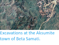
In a paper published in the January 2022 edition of the American Journal of Archaeology, Alfredo González-Ruibal and Jorge de Torres of the Institute of Heritage Sciences of the Spanish National Research Council, independent archaeologist Candela Martínez Barrio, Manuel Antonio Franco Fernández, also of the Institute of Heritage Sciences of the Spanish National Research Council, Adolfo Fernández Fernández of the Faculty of History at the University of Vigo, Pablo Gutiérrez de León Juberías, again of the Institute of Heritage Sciences of the Spanish National Research Council, José Yravedra Sainz de los Terreros of the Prehistory Teaching Unit at the Complutense University of Madrid, Michela Gaudiello of the Department of African Studies at Warsaw University, and Somali archaeologist Ahmed Jama Dualeh, present the results of archaeological exploration carried out on first millennium AD sites on the coast of Somaliland between 2018 and 2020, and the insights these provide into the links between the nomadic pastoralist peoples inhabiting the area at the time, and the wider global economy of the ancient world. Somaliland was a province of Somalia until 1991, when it unilaterally declared independence from Somalia at the outbreak of the Somalian Civil War. Few outside countries recognised this independence, but it did serve to protect Somaliland against much of the chaos that enveloped the rest of Somalia.
As well as the trade networks of northeast Africa and the Roman world, the nomadic pastoralists of the Horn of Africa were connected to the Indian Ocean trading system, which reached from northwest Europe to China, and included states such as the Roman and Byzantine empires, the kingdoms of Meroe and Aksum in Northeast Africa, the kingdom of Himyar in South Arabia, the Parthian and Sassanian empires in the Middle East, and the Middle kingdoms and the Gupta empire in India. This trade network began to develop around the end of the last century BC, and is considered to have been fully operational by the middle of the first century AD, surviving until the 19th century, when European settlers took control of much trade in the region. This trade network allowed for the movement of both goods and ideas over huge distances, and played a major role in the development of cultures around the Indian Ocean, and the way in which they interacted with one-another. As with other trade networks, nomadic groups are likely to have played a major role in the operating of this system, although they have been, to date, largely overlooked.

Whilst the Horn of Africa could seem like a backwater in such a global trading network, it is located at the (strategically important) entrance to the Red Sea, as well as being the conduit for valuable goods from the African interior, such as ivory and incense. Outside of the archaeological evidence, our main source of information about trading around the western Indian Ocean in early Roman times is the Periplus Maris Erythraei, an account of this trade apparently written by an anonymous sailor who plied these routes. In this document, the Horn of Africa is referred to as the 'Far Side Ports', with a number of trading centres listed; Avalites which is thought to be modern Zeila, Malaô, probably Berbera, Mundu, probably Xiis, Mosyllon, Arômatôn Emporion ('Spice Market'), probably modern Daamo, and Ôpône, probably Ras Hafun. The first archaeological excavations in the area were carried out by the French traveller Georges Révoil at Xiis, and produced a large amount of Roman glassware, supporting the Periplus Maris Erythraei's account of the importance of the area. No further excavations were carried out until the 1970s, when British archaeologist Neville Chittick carried out excavations at Daamo and Ras Hafun, south of Cape Guardafui, where he found pottery from Rome, Parthia, and India, dating from the first to third centuries AD (Daamo) and the second to fifth centuries AD (Ras Hafun). Pottery thought to be ancient on origin has also been found at the Nugaal River mouth, 250 km to the south of Ras Hafun. No evidence of coastal ports trading with the ancient world has been found south of the Nugaal River, though Hellenistic and Roman coins have been found in Mogadishu and Buur Gabo.
Previous archaeological work on trade around the western Indian Ocean has overwhelmingly concentrated on urban centres and larger states, but, as with other such trade networks, nomadic groups are known to have been part of this system, and in areas such as northeast Africa, to have been important players. Since 2015 archaeological in Somaliland, has attempted to better understand these groups, and has along with Puntland (another area acting as a de facto breakaway state from Somalia, and the area Neville Chittick explored in the 1970s), has provided the most easterly evidence for commerce with the ancient world in Africa to date.
González-Ruibal et al.'s work builds upon previous work by staff from the Department of Archaeology of Somaliland, who have surveyed known archaeological sites across the territory and produced a map of Somaliland's archaeological heritage, although this work did not add to the short list of sites with known links to the outside world left by Georges Révoil and Neville Chittick. González-Ruibal et al.'s work began around Xiis, where the best documented evidence of external trade has previously been found, and was intended to carry on their for several years. However, this work was interrupted by Cyclone Pawan in late 2019 and the COVID-19 pandemic of 2020, causing González-Ruibal et al. to shift their attentions to the area around Berbera, enabling a comparison between the two different regions.
In 2018-19 González-Ruibal et al. carried out an extensive survey of the coastal plain at Xiis. The main site here comprised over 300 structures, interpreted as tombs, which were surveyed and mapped using GPS positioning. Surface material not associated with any structure was also recorded, with extensive material being found on the islet of Xiis and on Ma’ajilayn Hill, which overlooks the site. Four tombs were excavated in 2019, with each stratigraphic layer being documented photogrammetrically. Human remains were subject to osteological analysis by physical anthropologist Candela Martínez Barrio both in situ, and at the Museum of the Department of Archaeology in Hargeisa.

The Berbera region, 210 km to the west of Xiis, was first surveyed in 2015-17, producing a wide range of archaeological sites, dating from the Neolithic to the 19th century, but nothing from the first millenium AD. In 2020 González-Ruibal et al. returned to this area, surveying inland as far as Burao, 116 km from the coast. This survey revealed several pre-Islamic necropolis, with those that produced evidence of long-distance trade being subjected to detailed surveying and mapping.
Faunal remains were sent to the Complutense University of Madrid for analysis by zooarchaeologist José Yravedra, and a selection of pottery sent to the University of Vigo, where they were studied by Roman pottery expert Adolfo Fernández, but all other material was studied in Somaliland, and all material eventually deposited with the Department of Archaeology in Hargeisa.
In the Periplus Maris Erythraei the port of Mundu is described as a place 'where vessels moor fairly safely at the island that lies very near the shore'. This description fits well with modern Xiis, where a rocky island (also called Xiis) lies about 200 m offshore. The local landscape is dominated by the Ma’ajilayn Hill, which is flat-topped and steep-sided, providing good views of the surrounding landscape and seaways. The necropolis here has been known since the 19th century, but was not subjected to systematic surveying until 2017, when archaeologist Carl Phillips carried out a survey for a construction company planning a new road in the area. Phillips' survey supported Georges Révoil's assertion that the area was trading with the wider ancient world during antiquity, as did a preliminary survey by González-Ruibal et al. in February 2018.
González-Ruibal et al.'s survey found a total of 296 tomb-structures. These were distributed in five zones, A and B to the west of Ma’ajilayn Hill, C opposite Xiis islet, and D and E to the northeast of Ma’ajilayn Hill. These tombs are most densely packed in zones D and E, where González-Ruibal et al. concentrated their work. Further tombs can be found along the coast to both the east and the west, with a notable site at Shalaw, where a stele with a Sabaean inscription has been found.
The tombs at Xiis fall into two broad categories, circular tombs (78% of the total), generally arranged in clusters, and square tombs 18% of the total), generally arranged in rows, with a small number (4%) of indeterminate tombs, which are most likely badly weathered circular tombs. Excavation of both types of tomb has, to date, only produced single burials (no square tomb has been excavated at Xiis to date, but Neville Chittick excavated a similar tomb at Ras Hafun in 1976).

There are 39 square tombs at Xiis. These are typically 7-8 m across, with a perimeter of black volcanic stones, and a central cairn made from sandstone or coral. Seven of these tombs have 2-12 stelae (upright standing slabs), which might be a sign of South Arabian influence, as such standing stones are commonly associated with tombs there. Similar square tombs are known from elsewhere in Somaliland, Puntland, Somalia, and Kenya.

Circular tombs at Xiis are 2.5-10 m in diameter although they are generally smaller where they are more densely packed. Elsewhere, similar tombs can be larger, with circular tombs around Berbera often exceeding 10 m in diameter. These tombs can be 2-3 m high, although smaller tombs are generally only 0.5-1 m high. They have larger stone blocks at their base, providing stability, and rocks of contrasting colour (black volcanic and light-coloured limestone and coral) are used to achieve chromatic effects.

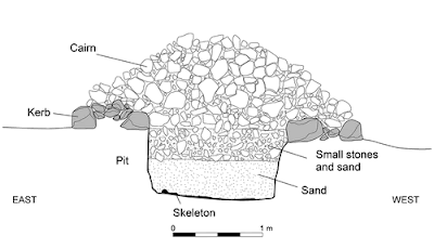
Most of these circular cairns have a crater or doughnut shape, leading to the term 'looter's pits' being used by Révoil, Chittick, and the local community. However, this appears to be the intended shape of these tombs, and even the central part of the 'pit' is well above the surrounding ground level, with the graves beneath being below ground level. This implies that had the pits been dug by looters, then they would have stopped before reaching the graves, and any grave goods within, and done so multiple times. Moreover, any such excavation by looters would be expected to leave material scattered on the surrounding ground, which is not the case. Similar doughnut- or ring-cairns have been recorded elsewhere in northeast Africa, but are uncommon in Somalia, where they are known only from Xiis, Ceelayo, and Qandala.

The square tombs are largely restricted to the easternmost part of the Xiis funerary complex (Zone E), while the other areas (Zones A-D) are dominated by circular tombs. There could potentially be a number of reasons for that; the square cairns could have been produced by a different social group, clan, or ethic group, been reserved for members of a different social strata, or have been produced at a different time. González-Ruibal et al. favour the latter explanation, noting that a number of factors favour the idea that the square cairns post-date the circular ones. Firstly, the square cairn excavated by Neville Chittick at Ras Hafun produced goods dated to the third to fifth centuries AD, later than the dates obtained by González-Ruibal et al. for items recovered from circular tombs (first to third centuries AD). Secondly, many of the square cairns appear to have started with a circular shape, then been modified to have a square shape, suggesting that the square cairns are a latter development that somehow evolved from the round cairns. Thirdly, the necropolis appears to have started at the base of the Ma’ajilayn Hill, and spread towards the coast, with the square cairns being closest to the sea, suggesting a later date.

The square tombs of Zone E are arranged in two rows flanking a small valley with an opening towards the sea, forming a sort of funerary avenue, something seen in later medieval cemeteries in Somaliland. Circular tombs are arranged in a series of clusters, each covering about 4500 m², and containing between 8 and 59 tombs. These clusters again may represent different social or kin groupings, but appear to have a chronological order. Clusters 1-5 spread along the base of Ma’ajilayn Hill, with Clusters six, seven, and eight, spreading towards the sea. Investigations of Cluster 3 found a single Roman glass flagon dated to the third century, while investigation of Cluster 4 found numerous Roman amphorae, dated to the first to second centuries, plus Italian terra sigillata, millefiori (mosaic glass), and ribbed glass, all dated to the first century.

González-Ruibal et al. excavated four of the round tombs at Xiis. 4, one in Cluster 2, two in Cluster 3, and one in Cluster 4.
Tomb 49 was located in Cluster 2, and comprised a simple ring of stones 2.6 m in diameter. Three fragments of green glass were found on the surface, but it was unclear if these were associated with the tomb or were later in origin. Two stratigraphic layers could be found inside the ring; a reddish sand interspersed with numerous small white stones, which covered most of the area, and an oval of greyish sand, which was found to be debris left by tomb robbers. The burial shaft in this tomb was one metre deep, with a Human skeleton in a supine position at the bottom. The only item found in the grave was a Sea Snail shell with a perforation which implies it was used as a pendant, although, since this was found close to the skeleton's feet, it is unclear if it was a deliberate inclusion in the tomb. It is possible that the grave originally contained other goods which were looted, and even that the glass fragments derive from an item that was originally in the grave, but this cannot be asserted with any confidence. Unfortunately it proved impossible to date the bones. The glass fragments on the surface probably date to between the first and third centuries AD.

Tomb 75 is located in Cluster 3, and is a oval cairn 2.7 x 2.0 m, and 57 cm high. This was reasonably intact, but with some evidence that looters had attempted to break into it from its northern edge. The cairn is made up of dark volcanic rock, with a basal layer of stones 60-80 cm in size, upon which the main structure was built of 30-50 cm stones. Removal of these visible stones revealed a layer of lighter coloured coral blocks 40-50 cm thick, and beneath this, another layer of volcanic blocks, again 40-50 cm thick. Beneath this was a layer of white sand with small chunks of coral and seashells, and beneath that a light brown sand, thought to be the original substrate. The white sand filled a pit 1.98 x 0.56 m orientated northwest-southeast, at the base of which was a flat stone at the southeast end of the platform and the remains of a wooden platform at the northwest end, beneath which was a badly decayed Human skeleton.

The skeleton was male, about 1.68 cm high, and estimated to have been between 25 and 39 years of age at the time of death, with remarkably good dental health for a skeleton of this age from this time period. It was lying with its head to the northwest, facing south, and the bones were discoloured from contact with the decaying wood. No confirmed grave goods were found in this tomb; three of the shells found in the grave fill had perforations which might imply they were used as pendants, but again their position is ambivalent, making it impossible to know if their placement was deliberate. Not finding any grave goods associated with a burial this elaborate is in itself surprising. Neither the bones nor the wood from this tomb could be dated.
Tomb 120 was also found in Cluster 3, and was a circle of dark volcanic stones 3.7 m in diameter and 1.5 m high. This was made up of blocks of 20-30 cm, resting on a base platform made of blocks of 70-100 cm. Beneath this was a substrate of alternating layers of white and light brown sand, with the while sand having potentially had white gypsum (available locally) mixed into it. The actual grave was found beneath two layers of each type of sand, and comprised a pit 1.60 m long, 0.50 m wide, and 0.67 m deep, with an east-west orientation. The fill of this grave contained a single Clam shell, identified as Anadara uropigimelana, without any modifications. At the bottom of the grave was the skeleton of a child aged 7.5 to 9.5 years, lying supine with the head to the west, facing south. The preservation of the skeleton is poor, with the feet having decayed and left hand being completely decayed, and many other bones partially lost. In addition, it has been partially flattened by the weight of the cairn above.

A range of grave goods were found within this burial. These include a 22 cm tall Roman glass flagon placed next to the head, a a necklace of 24 beads (12 blue glass, six faience, and six bronze), around the neck and an iron anklet on the right ankle. The sex of the skeleton could not be determined, but jewellery is more common in female burials in the Horn of Africa, suggesting that this was the grave of a young girl.

Tomb 153 in Cluster 4 was identified as noteworthy during the 2018 season, and excavated in 2019. The tomb had previously been looted, but had a large amount of material scattered around it, marking it out as being of interest. Because of the damage to the tomb, caused both by the looters and torrents flowing from the slope of Ma’ajilayn Hill, it was impossible to determine its original size and proportions, but it appears to have been a rectangular structure surrounded by a stone ring about 6 m in diameter, beneath which were layers of light and dark sand with stones and sea shells. Only a few fragments of Human remains could be found, including a phalanx.
Despite this disturbance, a surprisingly wide range of goods were found in the burial pit beneath the tomb, which was 1.8 m deep, and contained glass fragments representing at least three monochrome vessels, one of which could be identified as a pillar-moulded bowl, and at least two millefiori bowls. These glass fragments suggest a date from the last century BC or the first century AD. In addition, there were 25 strips in white or red glass paste, thought to have originally decorated a box or casket, and four items of pottery: a small vessel of Mesopotamian Glazed Ware with green glaze, straight neck, and flaring rim; a fragment of Italian terra sigillata; a sherd of a Roman amphora; and a bowl of Egyptian fine ware. There were also two beads, one carnelian and one glass, and a piece of iron. Scattered around the tomb were fragments of many Roman amphorae and South Arabian Organic Storage Jars, though it is unclear if these were removed from the tomb (or a neighbouring tomb) by the grave robbers, or were the results of a funerary feast.
As well as the items found in, or associated with tombs, a number of items were found on the surface at Xiis in locations not directly connected to the tombs. These were found in three main areas, on the Islet of Xiis, the top of Ma’ajilayn Hill, and in an area in the foothills to the southwest of Cluster 4.
The top of Ma’ajilayn Hill produced numerous fragments of cooking pottery and South Arabian Organic Storage Jars, but only a few fragments of glazed ware. In addition, three sections of stone wall, including what appeared to be the corner of a building, were found, although it is unclear if they were linked to the other material at the site. This may imply occasional temporary settlement of the area, which would provide a good view over the surrounding land and sea.
On the Islet of Xiis, a few pieces of pottery were found, including some plain wheel-made items, but no fine ware and no storage vessels, which makes it unlikely goods were ever offloaded here. Again some low walls were found. González-Ruibal et al. suggest this area may have been used as a temporary campsite by merchants arriving by ship.
Finally, an area of boulders, small rock shelters, and outcrops, at the foot of Ma’ajilayn Hill produced a large number of Roman amphorae, South Arabian Organic Storage Jars, a few fragments of wheel-made kitchenware, and a selection of fragments of finer ware, including the remains of various glass vessels, pieces of at least two different millefiori dishes, and the remains of an opaque blue glass vessel with undulating yellow bands, interpreted as a core-formed glass alabastron or aryballos (glass containers used for high value liquid items, such as rare oils or perfumes).
Two of the amphorae fragments had the remains of inscriptions; one large vessel, interpreted as having come from a Koan or Rhodian amphora, has the letters A, Y, and N, while a smaller vessel had the letters Δ and K. A number of locally made items were also found here, including a fragment of a handmade finger-printed rim and three shell beads.

Most notable at this site was the discovery of a number of pieces of resin. These are a particularly significant find, as they support the identification of Xiis with the trading centre of Mundu, which is recorded in the Periplus Maris Erythraei as having been an important source for three types of resin, myrrh, frankincense, and mokrutu. These are likely to have come from the Daallo Mountains, to the southeast of Xiis, which are home to three varieties of incense-yielding trees: Boswellia frereana, Boswellia carterii, and Commiphora myrrha. This situation is unique to the Daallo Mountains, nowhere else in the Horn of Africa or South Arabia can these three trees be found growing together, and access to this resource could have made Xiis an important trading centre in ancient times.

The discovery of such a large amount of imported material at Xiis (where locally made pottery makes up less than 1% of the total assemblage), strongly supports the concept as the location being a trading centre well connected to international networks. The most abundant material found here is Mesopotamian Glazed Ware, being found associated with 46 cairns, followed by various types of glass, associated with 25 cairns, then fragments of Roman amphorae, 19 cairns, and undecorated wheelmade wares, 15 cairns. Seven cairns had glass or stone beads associated with them. Sites away from the necropolis produced large numbers of South Arabian Organic Storage Jars and Roman amphorae, also evidence of imported goods.
Many of the pottery and glass items found by González-Ruibal et al. and Révoil are of high value. Révoil's collecting is known to have been highly selective, collecting high value items to the exclusion of both local pottery and items such as amphorae, but his material still provides evidence of long distance trade, including fragments of at least 11 millefiori dishes and bowls (to which González-Ruibal et al. have added another four), as well as inlays, plaques, and tiles, often highly decorated, which are thought to have originally been set into wooden or ivory boxes or other containers, and most likely produced in Alexandria or nearby. Some palmette-decorated inlays resembles material from the royal tombs at Meroe, dated to the middle of the first century AD. The site also produced blue-green pillar-moulded glass bowls (with González-Ruibal et al. and Révoil finding two each), which can also be dated to the middle of the first century AD.

The amphorae are mostly of the Dressel 2-4 type, which were produced between the last century BC and the second century AD, and generally used to transport wine. Most of these come from Italy, but there are examples from Cilicia, the Argean region and Egypt. Other amphorae found include examples of the Egyptian AE3, Gauloise 4, and Cilician Agora M54 types, also used for wine. Also present were numerous South Arabian Organic Storage Jars, which were made in India as well as Arabia, and used to transport a range of liquid foodstuffs.

This paints a picture of an area with trade links to the Roman Empire, South Arabia, the Parthian Empire, and to a lesser extent, India. Written sources from Antiquity tend to place an emphasis on Roman trade with the rest of the world, but generally took little interest in trade between other regions. This picture was emphasised by Georges Révoil's selective collecting, which placed an emphasis on high value goods from the Mediterranean region, but tended to ignore more common trade goods, but is counteracted by González-Ruibal et al.'s more detailed study, which reveals trade links with a wider sphere.

The Berbera region has been trading with the wider world since at least medieval times, and González-Ruibal et al.'s initial surveys found an abundance of sites dating from the eleventh century AD or later, but little earlier material. However, the 2020 survey was able to find some evidence of trade between the region and the rest of the world predating medieval times. The name Berbera derives from Barbaroi, a term used to describe the area in Greek and Roman texts, and which was being used by Arab traders as late as the 14th century. The term Barbaroi has been applied to various parts of Africa historically, but has been used specifically for the Somaliland area since at least the Early Islamic Period.

Historically, the name Malâo in the Periplus Maris Erythraei has been associated with Berbera, although this is much less likely than the association of Mundu with Xiis. Malâo is described as sheltered by an ἀκρωτήριον to the east, a term usually translated as a promontory or cape, something completely absent in the Berbera area. However, Berbera does have a sand spit, which the early twentieth century classical scholar Wilfred Schoff thought made it a candidate for the location of Malâo. González-Ruibal et al. reject this hypothesis, suggesting instead that Malâo refers to Siyaara, 30 km tro the east of Berbera, which does have a distinctive rocky promontory, the only such structure between central Somaliland and Djibouti, and where some evidence for ancient trade has been found. Furthermore, Siyaara has drinkable water available from wells year-round, something which Berbera lacks, and has been an active trade centre since at least the eleventh century AD.
The trading port at Berbera, in contrast, is located on an island, something not mentioned in the Periplus Maris Erythraei. There has been a settlement here since at least the sixteenth century, and probably much longer, although the modern town is built over the older settlement, making it hard to date precisely, though evidence of medieval trading has been found in the area.
Taking a wider view, however, González-Ruibal et al. consider the entire Berbera region rather than just the modern port, and examine an area running 100 km along the coast from the Issutugan River east to Siyaara, and inland as far as Yiroowe, 130 km from the coast. This area contains no monuments as obvious as the Xiis necropolis, but does contain a number of individual cairns, some of which are thought to be pre-Islamic in origin.
The port of Siyarra is known to have been home to a major seasonal fair from at least the eleventh century till the sixteenth. Surface surveys in this area have produced large amounts of medieval goods, notably imported glass, pottery, and jewellery, but also a few earlier items, notably fragments from three jars from the Himyarite Kingdom, which occupied roughly the area of modern Yemen, between about 100 BC and about 520 AD.

Siyarra lacks an obvious necropolis, but several cairns are located in the area around the city, at least two of which are clearly pre-Islamic in origin, and two more, one in Siyaara and another on the coast 4 km to the southwest, are located on the shore in such ways that they are conspicuous when seen from the sea, but more-or-less hidden from inland.

Possibly the most significant sites on the Berbera coast are found around Ceel Gerdi, a small hamlet located 22 km to the east of the port of Berbera. Here a series of six shell middens can be found on a six km stretch of coast. Three of these are clearly Neolithic, and have produced pottery material dated to the second millennium BC. The remaining three, identified as Ceel Gerdi 2, Ceel Gerdi 8, and Ceel Gerdi 9, have produced imported artefacts dated to the first millennium AD, with another pottery fragment which may be an imported first millennium AD item, found on the surface in the village itself. These shell middens cover fairly large areas, Ceel Gerdi 2 about 2800 m² in a flat area amid dunes, Ceel Gerdi 8 covers about 1500 m² on a dune top, about 2.7 km to the northeast of Ceel Gerdi 2. Ceel Gerdi 9 is smaller, covering only about 100 m², and is located in a flat area between dunes, to the east of Ceel Gerdi 2 and close to the Neolithic Ceel Gerdi 1. These sites are not stratified, with all material apparently on the surface, which González-Ruibal et al. suggest is a result of nomadic groups returning to the same site, but not the same exact spot, repeatedly over a period of many years. All of these sites yielded handmade pottery, imported pottery, flint flakes and cores, Ostrich egg shells, Turtle shells, Fish bones, and, sea shells, while Ceel Gerdi 2 also produced Animal bones, handstones, pounders, and net sinkers.

Analysis of the shells at part of Ceel Gerdi 2 found that the site was dominated by Spider Conchs, Lambis spp., and True Conchs, Tricornis spp. (both types of large marine Snail), but other areas of the middens appeared to be dominated by other shells, with Ceel Gerdi 8 dominated by the Clam Anadara antiquata, suggesting that tastes or foraging habits varied over time. Fish bones were also common, with bones assigned to large members of the Serranidae (possibly Groupers) were found at Ceel Gerdi 2 and Ceel Gerdi 8, while bones attributed to the Sparidae (Sea Bream) or Lethrinidae (Emperor Fish) were also found at Ceel Gerdi 8. All of these Fish could potentially be caught from the shore, although the Periplus Maris Erythraei describes the people of the Babaroi area as being able to cross the Gulf of Aden to trade with Yemen, implying that they had some form of boat and could potentially have fished from the sea.

View of shell midden Ceel Gerdi 8 from the southwest. González-Ruibal et al. (2021).
Seven different types of pottery were found in the Ceel Gerdi middens. One of them is thought to have been local, and made up 95% of the material found. This is made from a course brown-to-grey material with abundant large inclusions, from which hand-made bowls were produced and decorated with shell impressions. This is essentially a development of the Neolithic tradition in the area, when similar bowls were made, but with different decoration.

Local handmade pottery from Ceel Gerdi 2 (scale is in cm). González-Ruibal et al. (2021).

Other items at Ceel Gerdi which must have been imported include two pieces of obsidian, a bladelet core and a flake, which probably came from Yemen or northern Ethiopia, and a monochrome dark green bracelet, of a type manufactured in Egypt and the Levant between about 300 and 700 AD.
These finds do not suggest access to a major international trading network as seen at Xiis, but rather a more limited trade with other areas of the Horn of Africa and southern Arabia, and possibly the Red Sea. The Periplus Maris Erythraei, suggests that the trade goods to be obtained at Malaô were similar to those found at Mundu, incense, and sometimes slaves. It is likely that nomads visiting the coast at Ceel Gerdi could have brought with them incense harvested in the interior to trade, but they could also potentially have traded in goods obtained locally, notably Turtle shells, which were valued in the ancient world and listed as valuable commodities from many Far Side Ports in the Periplus Maris Erythraei. The presence of Turtle remains in the middens at Ceel Gerdi strongly suggests these Animals were being captured here. Ostrich eggs, which are also represented in the middens, could also have been traded; these are known to have been a valuable export from the region from at least the Early Islamic Period.
Exploring inland, González-Ruibal et al. found 22 necropolises with cairns close to natural routes between the coast and the escarpment dividing the coastal plain and the highlands. The largest of these was at Gugux, 65 km from the coast, where 44 burial mounds and a rectangular structure are arranged in a straight line orientated north to south. No surface material was found at this site, preventing easy dating of the locality, but neither was there any sign of any of the tombs having been broken into, which leaves good potential for future archaeological investigations.

Another such necropolis was found on the road between the town of Burao and the coast. Investigation of a cairn that had apparently been broken open by looters yielded no material at all, while examination of a 3.5 m diameter cairn not aligned with the main group found a bone protruding at the surface. This was taken for radiocarbon dating, yielding a postmedieval date, suggesting that either the tomb is recent or that the bone, which was found on the upper part of the cairn, is a later intrusion.

A group of four cairns was found on top of a flat-topped hillock at Yiroowe, 22 km southeast of Burao. Two of these are on the eastern edge of the hilltop, 30 m above the surrounding plain, have diameters of about 12 m, and are made of small stones (averaging about 10 cm). The other two cairns are located on the southern slope of the hill, and are smaller, with diameters of about 4 m. González-Ruibal et al. suggest that the smaller cairns are likely to be younger than the larger ones, since large cairns in this region have never been found to be younger than early second millennium AD, whereas small cairns were still being constructed in at least the 19th century. One of these smaller cairns had previously been broken into, although no material could be found associated with it by González-Ruibal et al. The larger cairns, however, had been disturbed by anthills, bringing some material to the surface.

The more southerly has several fragments of turquoise glass on the mixed in with its stones, which are believed to have come from a single vessel, although the nature of this vessel could not be reconstructed from the available material. A piece of pottery was found beside the more northerly cairn. This was made from a buff, friable material, and had a crazed green glaze, similar to the Mesopotamian Glazed Ware found in Xiis. González-Ruibal et al. suggest that these cairns probably date to before 700 AD, as later burials in the area would be Muslim, and unlikely to contain grave goods.

Finally, González-Ruibal et al. attempted to locate some of the other Far Side Ports mentioned in the Periplus Maris Erythraei. The port of Zeila has been suggested as a likely candidate for the ancient port of Avalites. However, no pre-Islamic material could be found either around the city or on the nearby island of Sacadin, which has produced large amounts of medieval remains. However, many large cairns flank the natural routes between this area and the Boroma Highlands of the interior, suggesting that this was an important trading area in ancient times.
The port of Mosyllon is described in the Periplus Maris Erythraei as being between Mundu and Arômatôn Emporion. If Mundu corresponds with modern Xiis, as seems likely, and Arômatôn Emporion is modern Daamo, as suggested by Neville Chittick, who excavated Ware and Dressel 2-4 amphorae there, then Mosyllon could be either Qandala, which lies in modern Puntland, or Ceelayo, on the Puntland-Somaliland border.
Satellite images show a necropolis of about 200 cairns at Qandala, on an escarpment facing the sea. The majority of these are circular or doughnut shaped, as at Xiis, and they range from about 2.5 m in diameter, up to about 17 m (larger than anything at Xiis), though most are smaller than 10 m. Unfortunately, Puntland is not as stable as Somaliland, and González-Ruibal et al. did not feel it was safe to visit this site, although the similarity to the necropolis at Xiis does suggest that the two sites are probably contemporary.

Ceelayo has an even larger necropolis, with about 500 tombs extending about 6 km along the coast. These tombs are again predominantly of the circular/doughnut shape, but square cairns similar to those at Xiis and Ras Hafun appear to be present too. Again, the similarities to other sites suggests an age range somewhere in the first half of the first millennium AD.
González-Ruibal et al.'s investigations at Xiis and Ceel Gerdi confirm the ancient accounts of trade in this area, and the earlier findings of Georges Révoil and Neville Chittick, as well as providing new insights into the subject. The site at Xiis appears to have been used between the first and third centuries AD, with trade moving to other locations (possibly quite nearby) after this. At Ceer Gerdi, the material from the middens suggests nomadic groups were visiting this area, presumably at least partially to trade, between the fifth and seventh centuries AD.
The variety and value of the goods found at Xiis implies that these nomad groups had high purchasing power, something that has also been observed for nomadic groups in other areas, such as Late Roman Egypt, where such groups controlled key trade routes and access to valued materials. Despite this, nomadic groups are often overlooked in both ancient and modern texts, and where mentioned, their importance tends to be downplayed, and the commodities in which they trade dismissed as common items of little value. This perspective was challenged by Georges Révoil's excavations, which showed that the nomads of the Somaliland coast were able to trade for high value items from distant locations, a finding supported by González-Ruibal et al.'s work, which shows that the material recovered by Révoil was not some unique, atypical finding. They suggest that this trade was probably driven by the export of high value incenses.
Furthermore, the similarity of the material found at Xiis to that found at other sites around the Western Indian Ocean, strongly suggests that these nomads were fully connected to the economic and cultural network that linked societies from Rome to India.
The goods imported were not just high value decorative items placed within tombs, as might be assumed from Georges Révoil's work, but also included large volumes of consumable items, such as wine, which have previously been overlooked. The large numbers of empty containers suggest that communal feasting was a part of the culture of these nomads, something seen in other groups living on the fringes of the Roman Empire. The Periplus Maris Erythraei notes that the provision of wine was considered to be important as a way for merchants to foster good relations with Barbaroi in East Africa and India, something that appears to be supported by the Xiis amphorae. González-Ruibal et al. do, however, present an alternative hypothesis for the presence of these amphorae, suggesting that nomadic traders may simply have been transferring the contents of amphorae to animal skins to make transport into the interior easier.
Another noteworthy finding is the individual nature of the burials at Xiis, Ras Hafun, Ceelayo, and Qandala. This represents a significant departure from the Neolithic practice in the region, where communual burials were the norm, as is the case in late first millennium AD cairns in Ethiopia. Whilst more excavations need to be carried out to confirm solitary burials were the usual, or even the most common, practice, this switch does seem to be significant. A long term chronology of burial practices in Somaliland has yet to be developed, but solitary burials appear to be connected to the first few centuries AD, and to the Islamic Period, both of which are associated with the development of long-distance trade networks. González-Ruibal et al. suggest that this might also have been linked to the development of a more stratified society, in which people were aware of social differences, which might in turn be reflected in the rich grave goods seen in some burials at Xiis.
The people at Ceel Gerdi appear to have been subsisting largely on Fish and shellfish gathered from the shore, which may link them to Greek and Byzantine descriptions of 'Ichthyophagoi', a negative image of primitive savages living around the Gulf Aden. Such peoples were depicted as poor, naked, using only stone and wooded tools, and largely dependent on Fish washed ashore in storms for sustenance. However, the fact that people looked primitive to Greek merchants does not imply that they were not capable of engaging in complex trading activities. and the people of Ceel Gerdi were probably trading incense and possibly other items with the Byzantine Empire, Oman, and the kingdoms of Himyar and Aksum.
Modern perspective on nomadic groups in antiquity tend to view the peoples living between Egypt and Somalia as a single homogeneous group. In contrast, Artemidorus, the author of the Periplus Maris Erythraei, clearly viewed the peoples of each of the Far Side Ports as being separate political and cultural entities, although he does not describe these people's cultures, while other ancient sources tended to view these peoples through a lens of negative preconceptions. In the absence of any reliable source of contemporary information, archaeology is the only tool we have to try to understand these (and many other) peoples of the ancient world.
Another noteworthy feature of this research is that the perception of trading always happening at fixed spots, which probably derives from a Mediterranean world dominated by city states (or later largely self-governing cities integrated into larger states), but which does not seem to tie in well with the situation on the Horn of Africa, where, in the absence of a centralised infrastructure that anchored people to specific locations, trading sites could change on small timescales due to changing political or climatic conditions. More localities have now been recorded on the coasts of Somaliland and Puntland than are mentioned in ancient sources, which suggests a variability in trading location unexpected by writers from the Mediterranean region. These locations probably varied with both the movements of nomads responding to seasonal changes and longer term climatic variations which would have necessitated moving to gain access to the best grazing for their herds, and those of sailors on the Indian Ocean, who had to deal with a far tougher climate than those who sailed the Mediterranean, and whose choice of mooring location would be driven by the rhythm of the monsoon winds. This makes it likely that many of the 'ports' listed in the Periplus Maris Erythraei were in fact seasonal fairs rather than permanent settlements, and that these fairs could be moved to new locations if the old ones became unsuitable for some reason.
See also...


Follow Sciency Thoughts on Facebook.
Follow Sciency Thoughts on Twitter.