Showing posts with label Subsidence. Show all posts

Wednesday, 1 January 2020

Flooding and landslides kill at least nine in Jakarta and West Java.

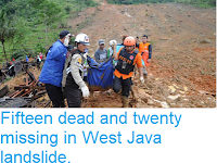
At least nine people have died as a series of flooding and landslide events hit Jakarta and West Java over the New Year period. Alvico Arif Ardana, 16, died after being electrocuted during a flood in the Kemayoran District of Jakarta on Wednesday 1 January 2020, while in the Cipinang Melayu District three people died of hypothermia after being caught in floods, all are believed to have been elderly. In the city of Depok in West Java four people, including an eight year old child, died in a landslide brought on by heavy rains. Landslides are a common problem after severe weather events, as excess pore water pressure can overcome cohesion in soil and sediments, allowing them to flow like liquids. Approximately 90% of all landslides are caused by heavy rainfall. One person is reported to have died in a flash flood in the city of Bogor, also in West Java. As well as the known fatalities around 19 000 people have been forced to flee homes in the Jakarta area due to flooding.

Flooding in Jakarta on 1 January 2020. AP.

Landslides are a common problem in Java, particularly during the Northeast Monsoon, which lasts from November to February, with peak rainfall in January and February, and can result in an annual rainfall of around of 4000 mm in parts of Central Java. This problem has been made worse as expanding populations has led to people farming higher on hillslopes, in an area where soils tend to be volcanic in action and poorly consolidated (i.e. lack much cohesion), making them more prone to landslides.

A rescue team evacuating residents of a flooded area of Jakarta on 1 January 2020. Achmad Ibrahim/AP.

Monsoons are tropical sea breezes triggered by heating of the land during the warmer part of the year (summer). Both the land and sea are warmed by the Sun, but the land has a lower ability to absorb heat, radiating it back so that the air above landmasses becomes significantly warmer than that over the sea, causing the air above the land to rise and drawing in water from over the sea; since this has also been warmed it carries a high evaporated water content, and brings with it heavy rainfall. In the tropical dry season the situation is reversed, as the air over the land cools more rapidly with the seasons, leading to warmer air over the sea, and thus breezes moving from the shore to the sea (where air is rising more rapidly) and a drying of the climate.

 Diagrammatic representation of wind and rainfall patterns in a tropical monsoon climate. Geosciences/University of Arizona.

Java has two distinct Monsoon Seasons, with a Northeast Monsoon driven by winds from  the South China Sea that lasts from November to February and a Southwest Monsoon driven by winds from the southern Indian Ocean from March to October. Such a double Monsoon Season is common close to the equator, where the Sun is highest overhead around the equinoxes and lowest on the horizons around the solstices, making the solstices the coolest part of the year and the equinoxes the hottest.

The winds that drive the Northeast and Southwest Monsoons in Southeast Asia. Mynewshub.

Jakarta has become increasingly prone to flooding in recent years, as it is slowly sinking below sealevel. This is largely due to the high rates of water extraction from aquifers beneath the city, to supply water to its 9.6 million residents, which has caused the water-holding sediment layers to deflate, lowering the ground level. In April 2019 the Indonesian Government announced that it planned to move the country's capitol to another location, probably a custom-built city on Borneo, due to concerns about the long-term habitability of Jakarta, which is threatened both by subsidence and rising sea levels associated with global warming, as well as pollution and overcrowding caused by the rapid rate at which the city has expanded.

See also...

https://sciencythoughts.blogspot.com/2019/10/eruption-on-mount-merapi-java.htmlhttps://sciencythoughts.blogspot.com/2019/10/assessing-potential-impact-of-planned.html
https://sciencythoughts.blogspot.com/2019/07/eruption-on-tangkuban-perahu-volcano.htmlhttps://sciencythoughts.blogspot.com/2019/05/landslide-kills-five-at-illegal-mine-in.html
https://sciencythoughts.blogspot.com/2019/02/landslide-kills-four-in-west-java.htmlhttps://sciencythoughts.blogspot.com/2019/01/fifteen-dead-and-twenty-missing-in-west.html
Follow Sciency Thoughts on Facebook.

Friday, 28 September 2018

Gaelic football club forced to close due to sinkholes in County Monaghan, Northern Ireland.

A Gaelic football club has been forced to close after a sinkhole opened up on Sunday 23 September 2018, damaging all of its pitches, as well as its clubhouse, five nearby houses and two sections of public road, which have also been closed off. The damage includes an area of subsidence about 120 m across, with two deeper holes within it. The Magheracloone Mitchells GAA club in County Monaghan, Northern Ireland, has now concluded that the site will not be able to re-open in the near future, and is looking for an alternative location.

Damage caused to the Magheracloone Mitchells Gaelic Football Club by a sinkhole in September 2018. BBC.

Sinkholes are generally caused by water eroding soft limestone or unconsolidated deposits from beneath, causing a hole that works its way upwards and eventually opening spectacularly at the surface. Where there are unconsolidated deposits at the surface they can infill from the sides, apparently swallowing objects at the surface, including people, without trace.

In this case the damage is thought to be related to old mineworkings beneath the area. The club lies above an old excavation by British Gypsum, which produces gypsum for use in plasterboard, connected to a mine still in use nearby. Since the event the company has admitted that it has recently started using the abandoned part of the mine to store water, which has led to the collapse of several supporting pillars (columns of unmined material, left in place to support the roof of a mine while excavations continue around them) beneath the area.

Damage to the pitch of the Magheracloone Mitchells Gaelic Football Club caused by a sinkhole. Border Region TV.

Gypsum is an evaporate rock, a form of calcium sulphate deposited as mineral-rich water evaporates, often around sulphurous hot springs or volcanic systems. It is a very soft rock, and soluble in water, so moisture entering gypsum deposits can cause major collapses and subsidence.

See also...

https://sciencythoughts.blogspot.com/2018/09/atlantic-storm-ali-kills-two-in-ireland.htmlhttps://sciencythoughts.blogspot.com/2017/10/measles-outbreak-in-dublin-and-county.html
https://sciencythoughts.blogspot.com/2016/10/selenium-arsenic-and-molybdenum-in.htmlhttps://sciencythoughts.blogspot.com/2016/07/jellyfish-damage-to-farmed-salmon-on.html
https://sciencythoughts.blogspot.com/2016/01/landslide-kills-twenty-three-sheep-in.htmlhttps://sciencythoughts.blogspot.com/2015/12/atlantic-storm-desmond-causes-three.html
Follow Sciency Thoughts on Facebook.

Thursday, 29 May 2014

Surface rebound on the Bangkok Plain.

A number of fast growing cities around the world have suffered subsidence as a result of over-extraction of water from aquifers in recent decades, in some cases resulting in severe damage to buildings and infrastructure. Many cities have attempted to mitigate this, either by regulating groundwater pumping or, in more extreme cases, deliberately pumping water back into affected aquifers. However the relationships between over-extraction, subsidence, decreased pumping and surface recovery are poorly understood, particularly as these are slow processes, where subsidence will generally persist for some time after measures to mitigate it are introduced.

In a paper published in the journal Geochemistry, Geophysics, Geosystems on 14 February 2014, Kazuya Ishitsuka of the Department of Urban Management at Kyoto University, Yo Fukushima of the Disaster Prevention Research Institute, also at Kyoto University, Takeshi Tsuji of the International Institute for Carbon-Neutral Energy Research at Kyushu University, Yasuhiro Yamada and Toshifumi Matsuoka, also of the Department of Urban Management at Kyoto University and Pham Huy Giao of the School of Civil Engineering at the Asian Institute of Technology in Pathuthani, Thailand, describe the results of a study of surface levels on the Bangkok Plain over the period November 2007 to December 2010, using the Phased Array type L-band Synthetic Aperture Radar (PALSAR) instrument on the Japan Aerospace Exploration Agency’s Advanced Land Observing Satellite (ALOS).

Bangkok is situated on an area of flat lowlands close to the Chao Playa River Delta. The city is located on top of a number of aquifers, and previously suffered severe subsidence due to over-extraction from two of these, the Phra Pradang, which is located at a depth of 60-80 m, and the Nakorn Luang, located at a depth of 100-140 m. In 1997 the Thai Government introduced to regulate and reduce the levels of extraction from these aquifers, since when water levels are known to have recovered, though the effect on the ground level is less certain.

A large area (about 250 km²) of the centre of Bangkok was found to be uplifting during the three years of the study. This area ran from the west bank of the Chao Playa River in the west to Suvarnabhumi International Airport in the east, the northern and southern boundaries of the uplift matching roughly the extent of urbanization on the plane. The northwest part of this area uplifted by 2-3 cm during the three years of the study period, the central part by about 3 cm and the southeastern part by about 1 cm. However to the northeast of the area of uplift was an area where subsidence was still occurring; here the ground sank by an average of 1 cm over the study period. This area is home to a large industrial complex.

Areas of ground movement on the Bangkok plain during the three years of the study. (A) Northwestern uplift zone, where the ground rose 2-3 cm; (B) central uplift zone where the ground raised an average of 3 cm; (C) southeastern uplift zone, where the ground rose an average of 1 cm; (D) subsidence zone, where the ground sank an average of 1 cm. Ishitsuka et al. (2014).

As well as detecting ongoing uplift across much of the study area, Ishitsuka et al. were able to detect strong seasonal variations in the amount of uplift occurring. This varied across the study area, but followed a predictable pattern, with the seasonal uplift beginning close to the Chao Playa River, then spreading outwards to other areas. This strongly implies that the aquifers are being filled from runoff from the surrounding plains via the river; however Ishitsuka et al. also consider an alternative scenario may be occurring, where clay particles close to the surface are swelling and shrinking due to seasonal runoff, and note that it is beyond the method used in the current study to differentiate between these alternative scenarios.

See also…

 Magnitude 6.0 Earthquake in Chiang Rai Province, northern Thailand.

The United States Geological Survey recorded a Magnitude 6.0 Earthquake at a depth of 7.4 km in southern Chiang Rai Province in...


 Oil spill devastates popular Thai tourist resort.

The popular tourist resort of Prao Bay, on Ko Samet Island off the coast of Rayong Province in Thailand has been covered by a 30 cm...


 Three workers killed in rockfall at Thai limestone quarry.

Three workers are known to have died following the collapse of a rockwall at a Thai quarry on Monday 3 June 2013, and another four...


Follow Sciency Thoughts on Facebook.

Thursday, 28 March 2013

Man swallowed by sinkhole in Shenzhen, South China.

A man was killed in Shenzhen City in Guangdong Province on Wednesday 27 March 2013, when a huge sinkhole opened up in a pavement in a residential area, swallowing him whole. Twenty-five-year-old security guard Yang Jiabin was swallowed instantly when the hole, described as eight meters wide and sixteen meters deep, opened up beneath him. He was pulled from the hole by rescuers, but died later in hospital.

Sinkhole in Shenzhen City which opened up on 27 March 2013. Guardian.

Sinkholes are generally caused by water eroding soft limestone or unconsolidated deposits from beneath, causing a hole that works its way upwards and eventually opening spectacularly at the surface. This particular one appears to have been formed when drainage pipes beneath the surface burst and washed away deposits. The area has been suffering heavy rainfall, which may have caused the pipes to overload, or they may have been damaged by work on a construction site adjacent to the affected pavement. Local authorities have launched an investigation.


Follow Sciency Thoughts on Facebook.

Wednesday, 15 August 2012

Massive sinkhole opens up in Assumption Parish, Louisiana.

On 3 August 2012 an area of woodland 100 m across in Assumption Parish, Louisiana, unexpectedly sunk 130 m into the ground, the tops of the Cyprus trees just visible through the mire that filled the hole. Local authorities have issued a mandatory evacuation order on about 150 homes in the area; this is short of a full compulsory evacuation order, and does allow people the option of remaining in their homes for the time being. The nearby Highway 70 was briefly close, while damage to a natural gas pipeline was investigated, but has now reopened.

Areal photograph of the Assumption Parish sinkhole. The tops of trees can be sen in the water that has flooded the hole. ABC News.

When the sinkhole opened up bubbling was observed at the surface and an oily sheen observed, causing concern that the hole could be linked to previous oil and gas exploration in the area, with the possibility of radioactive contamination (crude oil in some areas contains radioactive material). But investigations by the Louisiana Department of Environmental Quality revealed the oily material to be mostly diesel oil and found no trace of radioactive material.

The hole is now being linked to a brine extraction operation run by the Texas Brine Company in the area until last year. Such operations extract salt from subterranean deposits by injecting water into the saltbeds then removing the water with the dissolved salt, which can then be recovered and sold. Such operations can cause subsidence by removing layers of salt from underneath overlying rock beds. The Texas Brine Company, which still retains responsibility for the site, is drilling an exploratory borehole to try to determine the state of the salt caverns beneath the area, and is said to have made a 'substantial contribution' to a fund to assist residents of the evacuation zone, though how this fund will be administered is still not clear.


Follow Sciency Thoughts on Facebook.