Tuesday, 10 February 2015

The dangers of naturally occurring asbestos in southern Nevada.


Asbestos refers to a number of forms of naturally occurring fibrous amphibole minerals known to be highly carcinogenic, and also linked to a number of other health problems, including cardiovascular illnesses and immune system deficiencies. Exact definitions of asbestos vary, as they were originally intended to classify commercially useful asbestos minerals before the health risks were understood, which has caused problems for US regulators, as some minerals are classed as asbestos and subject to strict regulations, whereas others have been called ‘asbestos-like minerals’, which can potentially escape legislation. In one famous case in Montana lawyers representing a mining company tried for some years to claim that the company could not be held responsible for cases of asbestosis in the local community as the minerals involved were not technically asbestos, even though a direct link between dust from the mine and the health problems had been established.

In a paper published in the Soil Science Society of America Journal on 14 October 2013, Brenda Buck of the Department of Geosciences at the University of Nevada-Los Vegas, Dirk Goossens of the Department of Geosciences at the University of Nevada-Los Vegas and the Department of Earth and Environmental Sciences at the University of Leuven, Rodney Metcalf, also of the Department of Geosciences at the University of Nevada-Los Vegas, Brett McLaurin of the Department of Environmental, Geographical and Geological Sciences at Bloomsburg Univsity of Pennsylvania, and Minghua Ren and Frederick Freudenberger, again of the Department of Geosciences at the University of Nevada-Los Vegas describe the first discovery of naturally occurring asbestos minerals in Clark County in southern Nevada.

While such minerals have not previously been reported from southern Nevada, they are known from Mohave County in Arizona, which shares a long border with Clark County, where they are formed by hydrothermal alteration of minerals in Miocene granite intrusions. The Mohave granite outcrops which produce these minerals are located within the unpopulated Lake Mead National Recreation Area, and are not thought to present any immediate hazard to public health. However similar granite outcrops also exist in Clark County, and some of these outcrops are close to the population centres of Boulder City, Henderson and Los Vegas.

Buck et al. collected rock samples from seventeen rock outcrops in Boulder City, Black Hill and the McCullough Range, they also collected soil samples from desert surfaces and dirt roads, as well as samples of airborne sediments captured in traps at several locations, and clothing and a vehicle mounted spare tyre from an outdoor recreation centre in Boulder City.

All of the samples contained asbestos particles, and all of the particles found away from the granite outcrops were sufficiently similar to minerals collected at these sites that these sites are considered to be the sources of the minerals.

Scanning electron microscope (SEM)/field-emission scanning electron microscope (FESEM) images of minerals from the Clark County study: (a) amphibole fiber from soil in an alluvial fan along the western edge of Black Hill; (b) amphibole fiber bundles from rock at Martha P. King Elementary School, Boulder City; (c) FE-SEM image of curling fibers from rock at Martha P. King Elementary School; (d) amphibole fiber bundle from rock at Martha P. King Elementary School. Buck et al. (2013).

The asbestos fibres collected from Clark County appear consistent with fibres collected from other locations known to be carcinogenic, and are sufficiently airborne to be inhaled easily. Clark County had a population of over 2 million at the time of the 2012 census, mostly within the Las Vegas–Henderson–North Las Vegas conurbation. Populations in Boulder City and eastern Los Vegas are deemed to be at risk of exposure to wind-blown asbestos dust.

Landsat image showing the study area in southern Nevada. Granitic plutons are shown in red. Estimated areas of alluvium deposited from erosion of those plutons are shown in yellow. All sampling locations are shown as white circles and contained fibrous amphiboles. Buck et al. (2013).

The areas of highest risk of wind erosion are considered to be to the south and southwest of Boulder City, particularly the Eldorado Dry Lake and the sandy surfaces east of Highway 95. This area, while largely unoccupied, as used for a variety of human activities, and is crossed by a number of dirt roads. Winds in the area tend to blow from the south and southwest in spring and summer, and from the north and northeast in winter and autumn. Winds from the southeast are rarer, but do occur, blowing dust towards the more densely populated areas of Henderson and Los Vegas.

Dust storm entering Henderson–Las Vegas from the south; the McCullough Range is obscured by dust. Buck et al. (2013).

Boulder City is considered to be at risk year round, as it is bounded by asbestos-producing outcrops to the north and east, and by areas of asbestos containing sediment which are easily activated by the wind to the south and west. As such Buck et al. recommend that urgent action is taken to better assess the health risks presented by wind-blown asbestos dust within the city.

Dust generated by a single off-road vehicle driving on a dirt road in the McCullough Range. Buck et al. (2013).

See also…

Kimberlites are uncommon geological formations formed by the extrusion of mantle material from deep within the Earth. Despite the relatively small number of kimberlites known, they have been the subject of extensive...


Arsenic-based cattle-dips were used in South Africa from their first becoming available in1893 until...


The Bushveld Igneous Complex is the world’s most productive area for platinum group metals, responsible for about 80% of global production, as well as having significant reserves of many other metals. It covers an area of 66 000 km² across the North West, Gauteng, Mpumalanga and Limpopo Provinces of South...


Follow Sciency Thoughts on Facebook.

A new species of Grass Moth from Tibet.


Grass Moths, Crambidae, are generally small and inconspicuous, particularly when in a resting posture, with rolled wings on a Grass stem, though they are a variable group and some species are quite conspicuous. Most well studied members of the group are of economic importance, generally as pest species (the larvae are stem-borers, mainly of Grasses), though some species are used as controls of invasive plants, and one - the Bamboo Borer, Omphisa fuscidentalis, is used for Human consumption.

In a paper published in the journal ZooKeys on 22 January 2015, Wei-Chun Li and Dong Liu of the College of Agronomy at Jiangxi Agricultural University, describe a new species of Grass Moth from Galongla Mountain in Medog County, Tibet.

The new species is placed in the genus Metaeuchromius, which is found across North and East Asia, and given the specific name glacialis, in reference to the glaciers found in the immediate proximity of the area where it was discovered. The species is described from five male specimens attracted to a mercury lamp, which was being used to attract Moths as part of a study into the wildlife of the glacial regions of Tibet, which is considered to be under threat due to global warming.

Metaeuchromius glacialis, male in dorsal view. Li & Lui (2015).

The Moths are largely white, with darker markings on their forewings, thorax and heads. The forewings are 9-10 mm in length. The male moths were active in late July, and were collected at an altitude of 3415 m; their natural history is otherwise unknown.

The area where the specimens were collected, at the foot of Galongla Mountain. Li & Lui (2015).

See also…

Tortrix Moths, Tortricidae,  are predominantly small Moths with feathery wings found across much of the globe. They are ubiquitous members of the Insect fauna, but despite this have not been extensively studied...


Stem-mining Moths of the family Nepticulidae are found across the world, but are at their most numerous and diverse in Southern Europe. The larvae feed on...


The Lepidoptera (Butterflies and Moths) first appear...


Follow Sciency Thoughts on Facebook.

Asteroid 2015 CL passes the Earth.

Asteroid 2015 CL passed by the Earth at a distance of 1 659 000 km (4.32 times the average distance between the Earth and the Moon, or 1.1 % of the average distance between the Earth and the Sun), at about 1.20 slightly before 10.40 pm GMT on Sunday 8 February 2015. There was no danger of the asteroid hitting us, though had it done so it would have presented only a minor threat. 2015 CL has an estimated equivalent diameter of 16-49 m (i.e. it is estimated that a spherical object with the same volume would be 16-49 m in diameter), and an object of this size would be expected to break up in the atmosphere between 29 and 9 km above the ground, with only fragmentary material reaching the Earth's surface.

 The calculated orbit of 2015 CL JPL Small Body Database.

2015 CL was discovered on 8 February 2015 (the day of its closest approach to the Earth) by the University of Hawaii's PANSTARRS telescope on Mount Haleakala on Maui. The designation 2015 CL implies that it was the eleventh asteroid (asteroid L) discovered in the first half of February 2015 (period 2015 C).

2015 CL has a 228 day orbital period, with an elliptical orbit tilted at an angle of 3° to the plain of the Solar System which takes in to 0.32 AU from the Sun (32% of the distance at which the Earth orbits the Sun, considerably inside the orbit of Mercury) and out to 1.14 AU (14% further away from the Sun than the Earth). This means that close encounters between the asteroid and Earth are fairly common, with the last thought to have happened in December 2013 and the next predicted in December 2017. Although it does cross the Earth's orbit and is briefly further from the Sun on each cycle, 2015 spends most of its time closer to the Sun than we are, and is therefore classified as an Aten Group Asteroid.

See also...

http://sciencythoughts.blogspot.co.uk/2015/02/asteroid-2015-bf92-passes-earth.htmlAsteroid 2015 BF92 passes the Earth.       Asteroid 2015 BF92 passed by the Earth at a distance of 3 267 000 km (8.5 times the average distance between the Earth and the Moon, or 2.2 % of the average distance between the Earth and the Sun), slightly before 10.10 pm GMT on Saturday 7 February...

Asteroid 2009 DT10 passed by the Earth at a distance of 8 202 000 km (21.34 times the average distance between the Earth and the Moon, or 5.5 % of the average distance between the Earth and the Sun), slightly after 4.14 am GMT on Saturday 7 February...


Asteroid 2015 BX509 passes the Earth.   Asteroid 2015 BX509 passed by the Earth at a distance of 13 610 000 km (35.48 times the average distance between the Earth and the Moon, or 9.1% of the average distance between the Earth and the Sun), slightly before 3.25 pm GMT on Thursday 5 February...


Follow Sciency Thoughts on Facebook.
 

Subfossil Reptile remains from a garbage dump on Yoronjima Island.


Many small tropical and subtropical islands are thought to have impoverished faunas, due to extinctions of local animals caused by human activity, notably habitat modification and the introduction of exotic species. However few such islands possess extensive records of the fauna present prior to the onset of such human activities, making it very hard to assess the nature of their native faunas.

In a paper published in the journal Acta Herpetologica in July 2013, Yasuyuki Nakamura of the Tropical Biosphere Research Center at the University of the Ryukyus, Akio Takahashi of the Department of Zoology at Okayama University of Science and Hidetoshi Ota of the Graduate School of Human Scienceand Environment at the University of Hyogo discuss the discovery of a number of Snake and Lizard bones from a garbage dump on Yoronjima Island in the Central Ryukyus.

Yoronjima Island is a small, flat island covering 20.5 km2 with a maximum elevation of 97 m, and comprising mostly Pleistocene limestone terraces, located about 30 km to the northeast of Okinawajima Island and 40 km to the southwest of Okinoerabujima Island. It has been occupied sporadically since the Jomon Period (slightly over 2000 years ago), and continuously since at least the early fifteenth century, when a medieval fort was constructed on the island. The island currently retains about 4.94 km2 of native vegetation cover, including forest, shrub, and grassland.

The island is currently home to three species of Frogs, four species of Lizards and two species of Snakes; Hallowell’s Tree Frog, Hyla hallowellii, the Ryukyu Kajika Frog, Buergeria japonica, the Okinawa Narrow-mouth Toad, Microhyla okinavensis,  the Hokou Gecko, Gekko hokouensis, the House Gecko, Hemidactylus frenatus (probably introduced), the Ryukyu Five-lined Skink, Plestiodon marginatus, the Okinawa Green Grass Lizard, Takydromus smaragdinus, the Okinawa Green Snake, Cyclophiops semicarinatus, and the Brahminy Blind Snake, Ramphotyphlops braminus (also probably introduced).

Four other Reptile species have been historically reported from the islands, the Okinawa Keelback Snake, Amphies mapryeri, the Ryukyu Odd-tooth Snake, Dinodon semicarinatum, the Okinawan Tree Lizard, Japalura polygonata polygonata, and the Common Four-clawed Gecko, Gehyra mutilata, however these reports have never been confirmed, and their reliability is uncertain. However a recent study found the remains of the Rhacophorid Tree Frog, Rhacophorus viridis, which is not currently found on the island, at a garbage dump in central Yoronjima, suggesting that local extinctions of small animals have occurred here.

The island is also home to the Ryukyu Flying Fox, Pteropus dasymallus, and Watase’s Shrew, Crocidura watasei, which are thought to be indigenous to the island, and the Musk Shrew, Suncus murinus, Norway Rat, Rattus norvegicus, Black Rat, Rattus rattus, House Mouse, Mus musculus, and Japanese Weasel, Mustela itatsi, all of which are known to have been introduced. The Oriental Free-tailed Bat, Tadarida insignis, has also been reported on the island, though the status of this is unclear.

The study site is an abandoned garbage dump in the central part of the island. This has not been precisely dated, but from the nature of the Human refuse at the site is thought to have been in use from the late nineteenth century to the mid twentieth century. Most of the species recorded here are thought to be too small to have been targeted for Human consumption, suggesting that they were living on the site, probably consuming small arthropods drawn to the refuse. The specimens were obtained by sieving fine sands from the site, and are therefore all disarticulated.

The first species documented from the site is the Okinawa Green Snake, Cyclophiops semicarinatus. This is represented by 24 vertebrae, from the middle and posterior trunk sections of the spine, which appear to come from at least two individuals on the basis of their size. This species is widespread in the Central Ryukyus and is known to still be found on the island.

Trunk vertebra of snake Cyclophiops semicarinatus. Left to right: (top) anterior, lateral (left), posterior, (bottom) dorsal, and ventral views. Abbreviations are: con, condyle; cot, cotyle; di, diapophysis; ezs, epizygapophyseal spine; hk, hemal keel; na, neural arch; nc, neural canal; ns, neural spine; pa, parapophysisprz, prezygapophyseal accessory process; przf, prezygapophysealarticular facet; pozf, postzygapophysealarticular facet; sr, subcentral ridge; zy, zygosphene; zyf, zygosphenalarticular facet. Scale bar equals 1 mm. Nakamura et al. (2013).

The second species recorded is the Ryukyu Odd-tooth Snake, Dinodon semicarinatum. This species is represented by 21 vertebrae from the middle and posterior trunk parts of the spine thought to be from at least two individuals, a juvenile and an adult. This species has previously been reported from the island, but the reliability of these reports has been unclear until now.

Vertebra of Dinodon semicarinatum. Left to right: (top) anterior, lateral (left), posterior, (bottom) dorsal, and ventral views. Abbreviation: zygaf, zygantralarticular facet. Scale bar equals 1 mm. Nakamura et al. (2013).

The third species reported is the Okinawa Keelback Snake, Amphies mapryeri. This species is represented by 39 precaudal trunk vertebrae. Like the Ryukyu Odd-tooth Snake, this species has previously been reported from the island, but in the absence of supporting evidence the reliability of these reports has been unverifiable.

 Vertebra of Amphies mapryeri.Left to right: (top) anterior, lateral (left), posterior, (bottom) dorsal, and ventral views. Abbreviations are:hy, hypapophysis; pap, parapophyseal process; Scale bar equals 1 mm. Nakamura et al. (2013).

The fourth species reported is an unidentified Sea Snake, Hydrophiinae sp., recorded from a single trunk vertebra. Unlike all the other specimens in the study, this species is highly unlikely to have been living at the study site, and almost certainly got there as a result of Human consumption (Sea Snakes are eaten in the Ryukyus).

Vertebra of Hydrophiinae sp.. Left to right: (top) anterior, lateral (left), posterior, (bottom) dorsal, and ventral views. Abbreviation: di, diapophysis. Scale bar equals 1 mm. Nakamura et al. (2013).

The fifth species identified from the site is the Okinawan Tree Lizard, Japalura polygonata polygonata, identified from six right and four left maxillae, three right and three left dentaries, a proximal part of the right humerus, and a proximal part of the left femur. Like the Ryukyu Odd-tooth Snake and Okinawa Keelback Snake, this species has previously been reported from the island, bt without supporting evidence.

(A)   Right maxilla and (B) left dentary of the Okinawan Tree Lizard, Japalura polygonata polygonata, both in median view. Abbreviation: mg, Meckelian groove. Scale bars equal 1 mm. Nakamura et al. (2013).

The sixth species reported is the Ryukyu Short-legged Skink, Ateuchosaurus pellopleurus, represented by a single frontal bone (part of the skull). This species has never been reported from Yoronjima Island, though it is found in the Central Ryukyus.

Ryukyu Short-legged Skink, Ateuchosaurus pellopleurus, frontal in dorsal view. Abbreviation: pf, parietal foramen. Scale bar equals 1 mm. Nakamura et al. (2013).

The seventh species recorded from the site is the Ryukyu Five-lined Skink, Plestiodon marginatus, which is represented by one right dentary, two right and one left posterior mandibles, five right and one left humeri, one right femur, and one right and one left pelvic girdle. This species is still present on the island.

Right dentary of a Ryukyu Five-lined Skink, Plestiodon marginatus, in medial view.Abbreviation: mg, Meckelian groove. Scale bar equals 1 mm. Nakamura et al. (2013).

The eighth species recorded is the Okinawa Green Grass Lizard, Takydromuss maragdinus, which is represented by one left dentary and one right and one left pelvic girdle. This species is still present on the island.

Left dentary of aOkinawa Green Grass Lizard, Takydromuss maragdinus, in medial view. Abbreviation: mg, Meckelian groove. Scale bar equals 1 mm. Nakamura et al. (2013).

The ninth species recorded from the site is the Hokou Gecko, Gekko hokouensis, which is represented by specimens—three right and three left maxillae, two right and three left dentaries and five frontals. This species is still found on the island.

Lizard remains referred to Gekko hokouensis. (A) Right maxilla in medial view, (B) right dentaryin medial view, (C, D) frontal in dorsal (C) and ventral (D) views. Abbreviations are: amp, anteromesial process; pml, posterior maxillary lamina; pmp, posterior maxillary process. Arrows in (C) indicate the posterior extents of the prefrontal sutures. Scale bars equal 1 mm. Nakamura et al. (2013).

Next a number of bones belonging to one or more unknown species of large Gekko. These include three right maxillae, two right and one left dentaries, three frontals, and three left pterygoids. Some of these bones appear very similar to those of the Hokou Gecko, but are too large to be assigned to this species.

Bones assigned to an unknown Gekko species: (E) right maxilla in medial view, (F) right dentary in medial view, (G, H) frontal in dorsal (G) and ventral (H) views. Abbreviations are: amp, anteromesial process; pml, posterior maxillary lamina; pmp, posterior maxillary process. Arrows in (G) indicate the posterior extents of the prefrontal sutures. Scale bars equal 1 mm. Nakamura et al. (2013).

Finally one right and one left maxillae and four right and three left dentaries are assigned to Kuroiwa’s Leopard Gecko, Goniurosaurus kuroiwae, a species not hitherto recorded from the island.

Bones assigned to Kuroiwa’s Leopard Gecko, Goniurosaurus kuroiwae: left maxilla in medial view, and (J) right dentaryin medial view. Abbreviation: amp, anteromesial process. Scale bars equal 1 mm. Nakamura et al. (2013).

While it is possible that some of these species still remain on Yoronjima Island undiscovered, the nature of the island, small and flat, makes it particularly amenable to biological surveys, making this highly unlikely, strongly suggesting that many species present at the dump have become extinct in recent decades. Many of these species are considered to be forest loving, and the island has lost much of its native forest cover, but several other islands in the Central Ryukyus are known to host more diverse Reptile assemblages with less woodland, making this an unlikely explanation in itself.

Instead Nakamura suspect that the decline in Reptile and Amphibian species seen on the island may be linked to the introduction of the Japanese Weasel, Mustela itatsi, in the 1950s in an attempt to control the populations of introduced Rodents. This species has been linked to the demise of other island dwelling Reptiles and Amphibians in the Ryukyu and Izu Islands, where naïve prey species unused to Mammalian predators have quickly succumbed to this aggressive nocturnal predator.

See also…

http://sciencythoughts.blogspot.co.uk/2015/01/a-new-species-of-twig-anole-from-panama.htmlA new species of Twig Anole from Panama. Anoles are small Iguanid Lizards found in the Southern United States, Mexico, Central America and the Caribbean. Twig Anoles, Norops spp., form a distinct cluster of medium sized Anole Lizard species within the genus Norops. There are currently eight...
http://sciencythoughts.blogspot.co.uk/2014/11/a-new-species-of-velvet-gecko-from.htmlA new species of Velvet Gecko from the southern Kimberley of Western Australia. Velvet Geckos of the genus Oeduraare medium to large Geckos found across much of northern and eastern Australia, with isolated populations in the arid interior...
Phasmid Geckos are small climbing Geckos of the genus Strophurus found across much of northern Australia, where they inhabit stands of...
Follow Sciency Thoughts on Facebook.

Magnitude 2.0 Earthquake in Cumbria, northwest England.

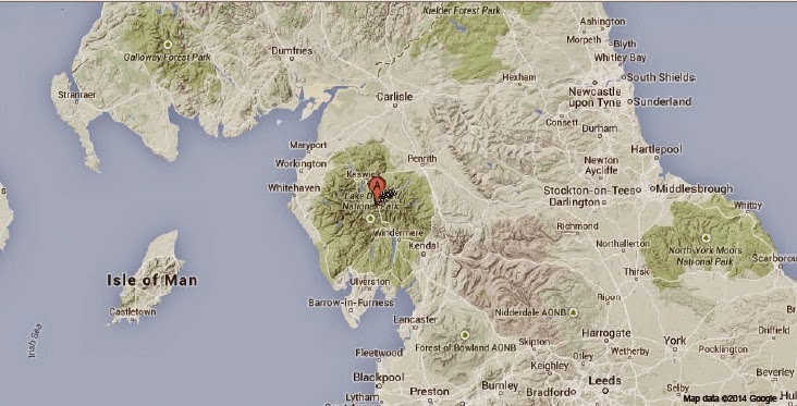
The British Geological Survey recorded a Magnitude 2.0 Earthquake at a depth of 12 km about 20 km to the southeast of the town of Kendle in Cumbria, northwest England, slightly before midday GMT on Monday 9 February 2015. Earthquakes of this size present no danger to human life or property, but may be felt locally.

 The approximate location of the 9 February 2015 Cumbria Earthquake. Google Maps.

Earthquakes become more common as you travel north and west in Great Britain, with the west coast of Scotland being the most quake-prone part of the island and the northwest of Wales being more prone  to quakes than the rest of Wales or most of England. However, while quakes in southern England are less frequent, they are often larger than events in the north, as tectonic presures tend to build up for longer periods of time between events, so that when they occur more pressure is released.
The precise cause of Earthquakes in the UK can be hard to determine; the country is not close to any obvious single cause of such activity such as a plate margin, but is subject to tectonic pressures from several different sources, with most quakes probably being the result of the interplay between these forces.


Britain is being pushed to the east by the expansion of the Atlantic Ocean and to the north by the impact of Africa into Europe from the south. It is also affected by lesser areas of tectonic spreading beneath the North Sea, Rhine Valley and Bay of Biscay. Finally the country is subject to glacial rebound; until about 10 000 years ago much of the north of the country was covered by a thick layer of glacial ice (this is believed to have been thickest on the west coast of Scotland), pushing the rocks of the British lithosphere down into the underlying mantle. This ice is now gone, and the rocks are springing (slowly) back into their original position, causing the occasional Earthquake in the process.
 
(Top) Simplified diagram showing principle of glacial rebound. Wikipedia. (Bottom) Map showing the rate of glacial rebound in various parts of the UK. Note that some parts of England and Wales show negative values, these areas are being pushed down slightly by uplift in Scotland, as the entire landmass is quite rigid and acts a bit like a see-saw. Climate North East.

Witness accounts of Earthquakes can help geologists to understand these events, and the structures that cause them. If you felt this quake, or were in the area but did not (which is also useful information) then you can report it to the British Geological Survey here.


See also...
 
http://sciencythoughts.blogspot.co.uk/2014/12/magnitude-20-earthquake-in-lake.htmlMagnitude 2.0 Earthquake in the Lake District, England.                                                       The British Geological Survey recorded a Magnitude 2.0 Earthquake at a depth of 13 km at the southern end...

The British Geological Survey recorded a Magnitude 1.8 Earthquake at a depth of 4 km approximately 5 km north of the village of Grasmere, in the Lake District in Cumbria...
On Friday 21 March 2013, slightly before 4.15 am, the British Geological Survey recorded a Magnitude 1.2 Earthquake at a depth of 3 km between Lake Ulswater and Haweswater Reservoir. This is a small quake...
 
Follow Sciency Thoughts on Facebook.
 

A new species of Munronia from Vietnam.


The genus Munronia comprises small woody shrubs from South and East Asia. There are currently four recognised species, Munronia pinnata, which is found from India and Sri Lanka in the west to Indonesia in the east and as far north as China (although this widespread and somewhat variable species has been described under a number of different names, now considered invalid), Munroni aunifoliolata, which is found in China and Vietnam (which has also been described under several other names now considered invalid), and Munronia humilis and Munronia breviflora from Indoneasia.

In a paper published in the journal Blumea on 11 December 2014, Nguyen The Cuong and Doung Thi Hoan of the Institute of Ecology and Biological Resources of the Vietnam Academy of Sciences and Technology and D Mabberley of the NaturalisBiodiversity Center in Leiden, Wadham College at the University of Oxford and the Royal Botanic Gardens & Domain Trust in Sydney, describe a new species of Munronia from Quang Ninh Province in Vietnam.

The new species is named Munronia petiolata, which is not explained but presumably refers to the species’ extremely long petioles (leaf stems). Munronia petiolatais a small shrub reaching 30-60 cm in height, with leaves arranged in spirals, clustering towards the ends of the stems. Flowers are white and produced from June onwards, fruit are produced in September. The plant was found growing in crevices in limestone on Bo Hon, Hang Luon and Cat Lanislands in Ha Long Bay in Quang Ninh Province. The known population is very small, and confined to a limited area, however Cuonget al. refrain from assigning it a conservation status pending further investigations.

Munronia petiolata. Branch bearing inflorescences and infructescences. Cuonget al. (201­4).

See also…

http://sciencythoughts.blogspot.co.uk/2014/06/the-freckled-cypripedium-classified-as.htmlThe Freckled Cypripedium classified as Endangered.                                                              The International Union for the Conservation of Nature published its annual update of its Red List of Threatened Species on Thursday 12 June 2014, marking the 50th year of the list's existence, and revising the status of a number of Plant and Animal species from around...
http://sciencythoughts.blogspot.co.uk/2013/09/a-new-species-of-turmeric-from-bu-gia.htmlA new species of Turmeric from the Bù Gia Mập National Park in southern Vietnam.                                  Turmeric (Curcuma) plants are members of the Ginger Family (Zingiberaceae) native to India, southern China, Southeast Asia, Indonesia, Papua New Guinea and northern Australia. Several species are grown for use as a spice or dye, and the more colourful species are popular garden plants in tropical areas, though they need constant warm temperatures and high rainfall to thrive. The plants can reproduce both sexually by flowering and asexually by means...
Follow Sciency Thoughts on Facebook.

Worker killed in rockfall at South Australian copper mine.

A worker has been killed in a rockfall at the BHP Billiton owned Olympic Dam Copper Mine in South Australia. Brian Partington, 47, was struck on the chest by falling rocks at about 6.00 am local time on Tuesday 10 February 2015. The cause of the incident is not yet clear, and production at the mine has been halted while an investigation is carried out by SafeWork South Australia and the local police.

The Olympic Dam Copper Mine. Inception Group.

The Olympic Dam Mine is the world's fourth largest copper mine and largest uranium mine, with 70% of its income coming from copper, 25% from uranium and 5% from other metals (principally gold and silver). The mine has faced criticism from environmental groups due to the amount of water it uses, but is considered a modern well equipped mine with a good safety record.

The approximate location of the Olympic Dam Mine. Google Maps.

See also...

A worker was killed in an accident at the Glencore Xstrata owned CSA Copper Mine in Cobar, New South Wales, at about 11.15 pm local time on Wednesday 11 June 2014. The worker has been described as a...

Two men have allegedly died following a drunken brawl at the AngloGold Ashanti operated Tropicana Gold Mine in Western Australia on Monday 19 May 2014. A 28-year-old truck driver is reported to have fallen...

A worker has died following an incident at the Stone Resources operated Brightstar Mine about 40 km east of Leverton in Western Australia. Full details of the incident are not yet available, but it is thought that a 63-year old man, employed by contractor CPC Engineering, died while operating a fork-lift truck at...


Follow Sciency Thoughts on Facebook.