Tuesday, 3 March 2015

Evacuations begin after major eruption on Villarrica.

Authorities in Chile have began to evacuate people from the vicinity of Volcán Villarrica, following a major eruption overnight between Sunday 1 and Monday 2 March 2015. Villarrica is active at some level more-or-less all of the time, but in mid February the level of activity began to rise sharply, leading to the Chilean National Service of Geology and Mining raising of the alert level around the volcano on Sunday. This was followed by a sharp rise in activity overnight, with material being thrown up to 600 m from the crater of the volcano and a sharp rise in Earthquake activity.

Volcanic activity on Volcán Villarrica. 24 Horas.

The volcanoes of Chile and the Andean region of South America in general are fed by the subduction of the Nazca Plate beneath the South American Plate along the Peru-Chile Trench, which lies offshore parallel to the west coast of South America. As the Nazca Plate sinks it is melted by the heat of the Earth's interior, and the lighter portions of it rise up through the overlying South American Plate to form volcanoes at the surface. These are dotted throughout the Andes Mountains; a range of mountains that is formed by a mixture of volcanism and crumpling of the South American Plate where is is forced against the Nazca Plate.

The subduction of the Nazca Plate beneath the South American Plate. Marot et al. (2012).

Volcán Villarrica is the westernmost of three volcanoes lying on the Gastre Fault Zone (the other two being Quetrupillán and Lanín, which are far less active) which runs toughly northwest-southeast, cutting across the Liquiñe-Ofqui Fault, which runs north-south along the Chilean Andes, and upon which the majority of the country's volcanoes sit. The Gastre Fault Zone is thought to be part of the ancient Lanalhue Fault Zone, which formed along an ancient subduction zone during the Permian (about 300-250 million years ago), during the assembly of the ancient supercontinent of Pangea.

The locations of the Gastre Fault volcanoes, Villarrica (green), Lanín (orange) and Quetrupillán (red). Google Maps.

See also...

The Projecto Observación Visual Volcán Villarrica recorded incandescence (glowing) around the crater of Volcán Villarrica, an active volcano in southern Chile, overnight between 4 and 5 February 2015. On 6 February tephra (hot fragmentary material) was observed being ejected from the crater, reaching...

The United States Geological Survey recorded a Magnitude 4.9 Earthquake at a depth of 51 km roughly 35 km to the west of Ovalle in the Coquimbo Region...


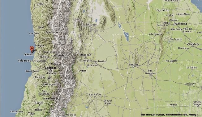
The United States Geological Survey recorded a Magnitude 5.1 Earthquake at a depth of 22.6 km, roughly 10 km offshore of the Chilean City of Quintero...


Follow Sciency Thoughts on Facebook.

Asteroid 2015 CO13 passes the Earth.

Asteroid 2015 CO13 passed by the Earth at a distance of 5 145 000 km (13.4 times the average distance between the Earth and the Moon, or 3.44% of the average distance between the Earth and the Sun), at about 7.30 pm GMT on Tuesday 24 February 2015. There was no danger of the asteroid hitting us, though had it done so it would have presented minor threat. 2015 CO13 has an estimated equivalent diameter of 30-94 m (i.e. it is estimated that a spherical object with the same volume would be 30-94 m in diameter), and an object towards the upper end of this range would pass through the atmosphere and directly impact the ground with a force of about 30 megatons of TNT (about 1800 times the explosive energy of the Hiroshima bomb), causing devastation over a wide area and creating a crater about kilometer across.

The calculated orbit of 2015 CO13. JPL Small Body Database.

2015 CO13 was discovered on 13 February 2015 (Eleven days before its closest approach to the Earth) by the University of Arizona's Mt. Lemmon Survey at the Steward Observatory on Mount Lemmon in the Catalina Mountains north of Tucson. The designation 2015 CO13 implies that it was the 339th asteroid (asteroid O13) discovered in the first half of February 2015 (period 2015 C). 

2015 CO13 has a 1033 day year orbital period and an eccentric orbit tilted at an angle of 3.13° to the plane of the Solar System, which takes it from 0.65 AU from the Sun (i.e. 65% of the average distance at which the Earth orbits the Sun, slightly inside the orbit of Venus) to 3.35 AU from the Sun (i.e. 335% of the average distance at which the Earth orbits the Sun, considerably more than twice the distance at which the planet Mars orbits the Sun). It is therefore classed as an Apollo Group Asteroid (an asteroid that is on average further from the Sun than the Earth, but which does get closer).

See also...

People across the state of Kerala in southwest India reported seeing a bright fireball in the sky between 10.00 and 10.30 pm local time on Friday 27 February 2015. A fireball is defined as a meteor (shooting...


Asteroid 2015 BA511 passed by the Earth at a distance of 14 800 000 km (38.5 times the average distance between the Earth and the Moon, or 9.9% of the average distance between the Earth and the Sun), slightly before 4.10 am GMT on Tuesday 24 February...

Asteroid 2015 CA40 passed by the Earth at a distance of 2 419 000 km (6.32 times the average distance between the Earth and the Moon, or 1.6% of the average distance between the Earth and the Sun), slightly before 9.50 pm GMT on Monday 23 February 2015. There was no danger of the asteroid hitting...


Follow Sciency Thoughts on Facebook.

Sunday, 1 March 2015

Fifteen people injured following Magnitude 5.4 Earthquake in Khyber Pakhtunkhwa Province, Pakistan.

The United States Geological Survey recorded a Magnitude 5.4 Earthquake at a depth of 28 km to the north of the town of Balakot in Khyber Pakhtunkhwa Province, Pakistan, slightly before 3.00 am local time on Friday 27 February 2015 (slightly before 10.00 pm on Thursday 26 February GMT). Earthquakes of this size are large enough to be dangerous, and this one is reported to have led to about twenty houses to collapse, with fifteen people sufficiently injured to require hospital treatment. The quake was felt across much of northern Pakistan.

The approximate location of the 27 February 2015 Khyber Pakhtunkhwa Province Earthquake. Google Maps.

Northern Pakistan lies on to the boundary between the Indian and Eurasian tectonic plates, which runs through northern Afghanistan, Pakistan and India. The Indian Plate is moving northward relative to the Eurasian Plate, causing folding and uplift along this boundary, which has led to the formation of the Hindu Kush Mountains of Afghanistan, the Himalayas and the other mountain ranges of Central Asia., and which makes the nations in this boundary zone prone to Earthquakes.

See also...

The United States Geological Survey recorded a Magnitude 5.8 Earthquake at a depth of 97.2 km in southern Badakshan Province, Afghanistan...


The United States Geological Survey recorded a Magnitude 4.0 Earthquake at a depth of 52.4 km in southeastern Kunduz Province, Afghanistan...


A report in the Times of India on 6 June 2014 has documented a possible volcanic eruption in the Kangra District of Himachal Pradesh State, India. The...


Follow Sciency Thoughts on Facebook.

A new species of Rove Beetle from Jalisco State, Mexico.


Rove Beetles of the genus Megarthrus are Fungus-feeding Beetles distributed globally, but are most numerous and diverse in north-temperate regions. In the tropics they are largely restricted to high altitude regions, leading to a large number of highly endemic species (species with very limited geographical ranges).

In a paper published in the journal Zootaxa on 13 February 2015, William Rodríguez and José Navarrete-Heredia of the Centro de Estudios en Zoología at the Universidad de Guadalajara describe a new species of Megarthrus from Jalisco State in Mexico.

The new species is named Megarthrus alatorreorum, in honour of Patricia Guillermina Alatorre Delgado and the Alatorre family in general for their ‘hospitality, respect and affection’. The Beetles were found in an Oak-Pine forest at altitudes of 2400-2800 m above sea-level, where they were captured in pit traps baited with squid, though they are not thought to be carnivorous. They range from 1.5-1.7 mm in length, and are dark brown in colour with paler appendages.

Megarthrus alatorreorum in dorsal view. Scale bar is 1 mm. Rodríguez & Navarrete-Heredia (2015).

See also…

Rove Beetles (Staphylinidae) are an unusual-looking group of Beetles, distinguished by their short wing cases, which makes them look rather unbeetle-like. They are a successful group, with over 46 000...

A new species of Marsh Rove Beetle from Japan.
Rove Beetles (Staphylinidae) are an unusual-looking group of Beetles, distinguished by their short wing cases, which makes them look rather...


A Rove Beetle from the Late Triassic of Virginia.
The Beetles are generally considered to be the most successful group of Insects, with over 360 000 known species and a fossil record that dates back to the Permian (or possibly the Carboniferous, depending on which experts you talk to). They are thought to...


Follow Sciency Thoughts on Facebook.

Fireball over Kerala State, India.

People across the state of Kerala in southwest India reported seeing a bright fireball in the sky between 10.00 and 10.30 pm local time on Friday 27 February 2015. A fireball is defined as a meteor (shooting star) brighter than the planet Venus. These are typically caused by pieces of rock burning up in the atmosphere, but can be the result of man-made space-junk burning up on re-entry. On this occasion the fireball was described as having a blue tinge, and moving quite slowly across the sky, leading to speculation that the object was more likely to be space junk than a meteor, since a blue colouration is often indicative of a high metal content, and a slow moving fireball sighted over Arizona on Tuesday 24 February has subsequently been identified as the remains of a Chinese rocket. However Indian air traffic controllers were not able to track the object, so it may have been a chondritic meteorite with a high metal content.

Blue fireball observed from Ernakulam District in Kerala. NDTV.

Following the event a number of fires broke out, on a vacant plot in the city of Kochi, at the village of Karumaloor near Aluva and the village of Mazhuvannur near Perumbavoor. Nobody was hurt in any of these incidents, and samples have been collected from two sites, Karumaloor and Mazhuvannur, for analysis by the Geological Survey of India.

Members of the Kerala State Disaster Management Authority examining the site of the Karumaloor fire on Saturday 28 February 2015. Vipin Chandran/The Hindu.


Objects of this size probably enter the Earth's atmosphere several times a year, though unless they do so over populated areas they are unlikely to be noticed. They are officially described as fireballs if they produce a light brighter than the planet Venus. It is possible, though unlikely, that this object will have produced meteorites that reached the surface (an object visible in the sky is a meteor, a rock that falls from the sky and can be physically held and examined is a meteorite), though most meteorites come from larger objects that penetrate further into the atmosphere before exploding, and therefore have a better chance of producing fragments that reach the surface.

See also...

A meteor estimated to be 60 cm across and to weigh in excess of 225 kilograms was observed over southwestern Pennsylvania early in the morning of Tuesday 17 February 2015. Scientists at the...


Fireball over Bucharest.                                           Witnesses reported seeing a large fireball over Bucharest, Romania, at about 3.00 am local time on Thursday 7 January 2015. The event is reported to have lasted several seconds, and to have lit up the...


The Irish Astronomical Association has reported a fireball over County Antrim in Northern Ireland at about 5.30 pm GMT on Tuesday 18 November 2014. The meteor was reportedly brighter than the Moon, and...


Follow Sciency Thoughts on Facebook.

Asteroid 2015 BA511 passes the Earth.

Asteroid 2015 BA511 passed by the Earth at a distance of 14 800 000 km (38.5 times the average distance between the Earth and the Moon, or 9.9% of the average distance between the Earth and the Sun), slightly before 4.10 am GMT on Tuesday 24 February 2015. There was no danger of the asteroid hitting us, though had it done so it would have presented only a minor threat. 2015 BA511 has an estimated equivalent diameter of 21-65 m (i.e. it is estimated that a spherical object with the same volume would be 21-65 m in diameter), and an object of this size would be expected to break up in the atmosphere between 21 and 5 km above the ground, with only fragmentary material reaching the Earth's surface, although since an object at the upper end of this range would be expected to release an amount of energy equivalent to about 12 megatons of TNT (roughly 700 times the energy released by the Hiroshima bomb), then being directly underneath it might be fairly unpleasant.

The calculated orbit of 2015 BA511. JPL Small Body Database.

2015 BA511 was discovered on 22 January 2015 (33 days befoe its closest approach to the Earth) by the University of Hawaii's PANSTARRS telescope on Mount Haleakala on Maui. The designation 2015 BA511 implies that it was the 12 776th asteroid (asteroid A511) discovered in the second half of January 2015 (period 2015 B).

While 2015 BA511 occasionally comes near to the Earth, it does not actually cross our orbital path. It has an elliptical 1063 day orbit, at an angle of 4.6° to the plane of the Solar System, that takes it from 1.07 AU from the Sun (1.07 times the average distance at which the Earth orbits the Sun), slightly outside our orbit, to 3.01 AU from the Sun, (3.01 times the distance at which the Earth orbits the Sun and roughly twice the distance at which the planet Mars orbits the Sun). As a Near Earth Object that remains strictly outside the orbit of the Earth it is classed as an Amor Family Asteroid. 

See also...

Asteroid 2015 CA40 passed by the Earth at a distance of 2 419 000 km (6.32 times the average distance between the Earth and the Moon, or 1.6% of the average distance between the Earth and the Sun), slightly before 9.50 pm GMT on Monday 23 February 2015. There was no danger of the asteroid hitting...


Asteroid 2014 EK24 passed by the Earth at a distance of 6 129 000 km (15.94 times the average distance between the Earth and the Moon, or 4.1% of the average distance between the Earth and the Sun), slightly after 5.30 pm GMT on Monday 23 February...


Asteroid 2015 DU passed by the Earth at a distance of 3 068 000 km (7.97 times the average distance between the Earth and the Moon, or 2% of the average distance between the Earth and the Sun), at about 10.00 am GMT on Monday 23 February 2015...


Follow Sciency Thoughts on Facebook.

Eruption on Mount Ambrym, Vanuatu.

The Vanuatu Geohazards Observatory issued a warning to the public on Saturday 21 February following an eruption from a new vent inside the caldera of Mount Ambrym a volcanic island in the New Hebrides. The eruption is apparently small in nature, but its prognosis is uncertain, and authorities are recommending people keep away from vents in the caldera and be alert for ashfalls downwind of the caldera. Ash columns have been reported above the volcano, and lava flows within the caldera. Raised sulphur dioxide levels have been detected across much of the Republic of Vanuatu, and as far away as New Caledonia.

Ash column over Mount Ambrym. Rocks can also be seen being thrown from the crater to the right. Georges Vitton/Volcanic News Eruptions.


Vanuatu is located on the southwestern fringe of the Pacific Plate, close to its boundary with the Australian Plate, which is being subducted along the New Hebrides Trench, to the west of the islands. The subducting Australian Plate passes under the islands of Vanuatu as it sinks into the Earth, causing Earthquakes as the plates stick together then break apart as the pressure builds up. As the plate sinks further it is partially melted by the heat of the Earth's interior. Some of the melted material then rises through the overlying Pacific Plate, fueling the volcanoes of Vanuatu.

See also...

Magnitude 4.8 Earthquake off the coast of Espirito Santo Island, Vanuatu.
The United States Geological Survey recorded a Magnitude 4.8 Earthquake at a depth of 5.6 km roughly 2 km southeast of Tutuba Island, Vanuatu, slightly...


Ash eruption on Mount Yasur, Vanuatu.
The Yasur Volcano near Sulphur Bay on Tanna Island has begun a new cycle of volcanic activity according to the Vanuatu Department of Meteorology and Geohazards. The volcano, which is one of the most active volcanoes of the Pacific Ring of Fire, has been relatively quiet since July last year, began ash...


Earthquake rattles Vanuatu.
On Sunday 21 October 2012, at 10.00 am local time (11.00 pm on Saturday 20 October, GMT), the United States Geological Survey recorded a Magnitude 6.2 Earthquake 109 km west of the island of Sola, part...


Follow Sciency Thoughts on Facebook.